Clinton House
Thursday, December 15th, 2016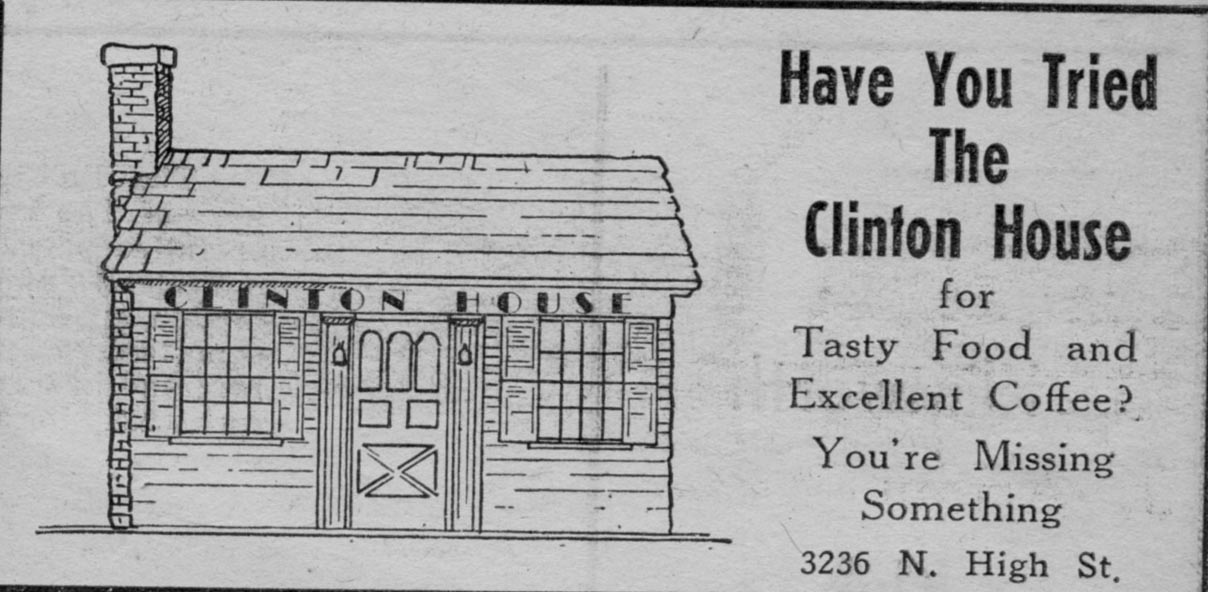 The Clinton House was located at 3236 North High Street in 1939, a building that now hosts a furniture refinishing business. In my book I show yet another generation of owners of this diminutive building.
The Clinton House was located at 3236 North High Street in 1939, a building that now hosts a furniture refinishing business. In my book I show yet another generation of owners of this diminutive building.
I realize these are low-quality photos, but they are, alas, the only photos that I have of this topic. Bob Meyer’s Standard Oil Station was located on the southeast corner of Morse Road and North High Street. It closed in 1984 after doing business more than 48 years. The photo above was taken in December, 1944, and the one below was taken in 1984 upon Bob’s retirement. Click through that 1984 image for the article about the station’s closing. [Photos courtesy of the Clintonville Historical Society]


This is a reprint of an article by Mary Rodgers, originally appearing in the newsletter of The Clintonville Historical Society.
A brief history of Charles T and Sadie M. Legg–long time Clintonville residents–based on The Booster news article dated February 12, 1937, with additions
Charlie Legg was born on the Legg farm on April 23, 1871. This farm, a dairy, was located North of Clintonville. The lane leading to the Legg homestead would have been near where Webster Park Avenue is today.
Charlie’s mother was Orell E. Webster, daughter of Amazon Webster and a direct descendant of Noah Webster of American Dictionary fame. His father was Lewis Legg, believed to be the son (or grandson) of Elijah Legg, a revolutionary war soldier from Massachusetts who settled in Ohio in 1815.
In 1937, Charlie reported that when his grandfather, Amazon Webster, moved to Clinton Township, Indians lived in the section now known as Indian Springs. Those Indians raised cranberries. Amazon told his grandchildren that the Indians would walk to Chillicothe to sell their berries.
Charlie’s grandmother was Mary Pinney of Worthington. She was the daughter of Levi Pinney and Charlotte Beach. Levi and Charlotte were the first couple to be married in Worthington, Ohio. That was 1839.
Sadie Mitchell was born on January 27, 1874 in Circleville. Her father was a builder. She became Charlie’s blushing bride on Thanksgiving Day, November 24, 1892. When she heard of the upcoming wedding, Sadie’s grandmother exclaimed, “Oh that name!” Sadie’s response was that it was no worse than the last four letters of her present name!
The Leggs were married by Rev. Louis Postle and their first home was behind Dr. Burbacher’s Offices, which were located on the Southeast corner of Oakland Park and High. The Mennonite Church stands here today. It was reported that after a year, in 1894, they moved to into a building that had been a church at the Northeast corner of Walhalla and High street (Clinton Chapel–now Southwick-Good and Fortkamp Funeral Home). They started a dairy farm. After a year, they moved to property located west of the Olentangy River near what is now Lane Avenue. Here they set up a “business” farm including the sale of corn to the Sells Circus. Today, if you are driving north on Kenny Road from Lane Avenue, you will see a road called Legg.
When Charlie’s father could no longer care for his farm, Sadie and Charlie combined their operation with his and moved to the North Clintonville homestead. In 1907, the Leggs sold the farm to developers Thompson, Johnson and Thompson. The neighborhood called the Webster Park Addition was platted. The Leggs built and sold three homes in this development. Orell Webster Legg, Charlie’s mother, retain the portion of the farm closest to the river. In 1909, a portion of her property was set aside for a bird sanctuary. We call this area the Delta.
According to the 1914 records, 346 families, a population of 1,190, represented Clintonville. The Clinton League Memory Book reports:
In 1913, a new two story brick building was erected on the corner of Dunedin Road and High Street. It was haled with delight by residents of the neighborhood for at this place Mr. Legg opened a grocery store and Mrs. Legg had a department for notions-live-savers they were where you lived five miles from town. There were two business rooms in this building so the post-office was moved to the one adjoining the store. It remained there until 1917 when rural mail delivery was established.” Today, this building houses Shim’s tailor and Melissa’s Incredible Edibles.
On July 4, 1916, Sadie’s dry goods business moved to 3339 North High. That building was built in 1910 by J. C. Loren. The Booster reported him as a well known contractor at the time. He may have built some of the early homes on East North Broadway. In fact, the home that was located at 615 East North Broadway, the carriage house for that home still stands and is know the Fisher home, was referred to as the Loren home in the Clinton Memory Book. We know that the developer of North Broadway, James M. Loren, never lived on North Broadway, so perhaps 615 was J. C. Loren’s home. Before Sadie, the 3339 North High building was occupied by Swope’s Grocery and Bilikam’s Grocery. Bilikam’s later moved to North Columbus. In 1918, the Leggs bought the building and Sadie operated her dry goods store at the site until February of 1937. Later in life, Sadie lived in the apartment above the store.
Mr. Legg, after selling his grocery, was a city salesman for the E. E. Shedd Mercantile Company and then worked for the L. E. and C. W. Medick Co., Ford Dealers in the Clintonville community. In fact, at her retirement in 1939, Sadie said that to get full enjoyment from her upcoming vacation, she would need a new V8 Model Ford. Charlie commented that he wouldn’t be receiving a commission on the upcoming sale.
The Leggs told The Booster that they recalled when a saloon existed at what would now be the southwest corner of Orchard Lane and High Street (the Kroger parking lot). The story is that while there were a dozen saloons in North Columbus, there were none in Clintonville. Then a man was elected mayor of Columbus who closed the saloons on Sunday. This drove the liquor dealers to move outside the city. In those days there was a “one-mile limit” law which meant that city police could arrest people within one mile of the city limits. So the new saloons were set up, including the one here. The local place did a “land-office business. ” The mayor found out however that the Clintonville saloon was a few feet inside the one mile limit. (The city limit at the time was Mock Rd–now Arcadia Ave.) So, on a Sunday morning he sent the “Black Maria,” as it was called in those days, to get the drunkards and the proprietor. A new mayor reopened the City saloons on Sunday and the Clintonville establishment failed.
When interviewed by The Booster in 1937, the Leggs recalled the tollgate that used to block High Street just north of Arcadia. The gate had a 3 cent per rig fee. They also recalled when “…there was no such a thing in those days as cross streets coming into High Street, except North Broadway. So the cars stopped at numbered stops…a pleasant memory when one thinks again of Stop 6 (now Pacemont–once known as Jason Avenue); Stop 7, (now Como); Stop 8 (North Broadway); Stop 9 Clintonville (Oakland Park). And then the stops were farther apart, and little used until one reached Cooke’s Corners (Cooke Road).”
Charlie and Sadie are buried in Walnut Grove cemetery on the south side of Worthington. Charlie passed in October of 1946 and Sadie in November of 1957.
Side note: One of Charlie’s sisters, Emma, married James Harvey Zinn, born 1 October 1871 Ohio, in 1895. J. Harvey Zinn was the President of the J. H. Zinn Lumber Company of Columbus, Ohio. Mr. Zinn was reported to be an ardent fisherman who followed his favorite sport in practically every part of Canada, as well as in Florida waters. His attractive estate “Edgewater,” was located on the Olentangy River just north of West North Broadway. This estate still exists in Clintonville; for more information listen to Robert Ohaver’s oral history.
[Article courtesy of Mary Rodgers and the Clintonville Historical Society]
 I’ve received several inquiries about whether I’ve ever encountered a map of the Indian Springs Golf Course. I haven’t, but would be interested in posting a digital copy of one on this web site.
Any former caddies out there with maps or golf course photos?
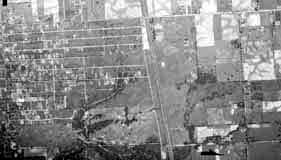
Bill Case, golf-course historian, sent me this 1938 aerial photograph of the land that is Wyandot Golf Club (top left corner, under the “1938”; you can see the ravine bisecting the course) and Indian Springs Golf Course is in the bottom left corner.
Bill says, “The attached is an aerial photo of Wyandot Country Club that I obtained from the county auditor’s office. The course is a couple of inches [i.e. inches on the original photo] directly below the June 15, 1938 notation on the photo. If you zoom in, you can make out pretty good detail of the holes. Morse Road is the lowest (or southern) boundary of the property. The driveway that winds its way straight north from Morse and then curves right or east toward the clubhouse is still there in use at the Deaf School. The trees and ravine divided the two area of the golf course.”
Between 1937 and 1980, the U.S. government–typically the USGS, BLM, or military–regularly took these aerial photos. They are impressively high resolution and lots of historic land-use information can be gleened from them. Original paper copies are available at the Office of the Franklin County Engineers, the Franklin County Auditor, and elsewhere.
 There is a new gastropub at Graceland Shopping Center, cutely named Pat and Gracie’s. The tavern is named after the early 20th century gambler who owned the land upon which Graceland Shopping Center was built: Pat Murnan and his wife Grace Backenstoe. The restaurant owners are on a quest to find an image of Grace Backenstoe. (They already have pictures of Pat.) Does anyone out there have one? Let me know and I’ll post it here as well as forward it to the restaurateurs. And thanks!
[Update: my update on this topic at here.]
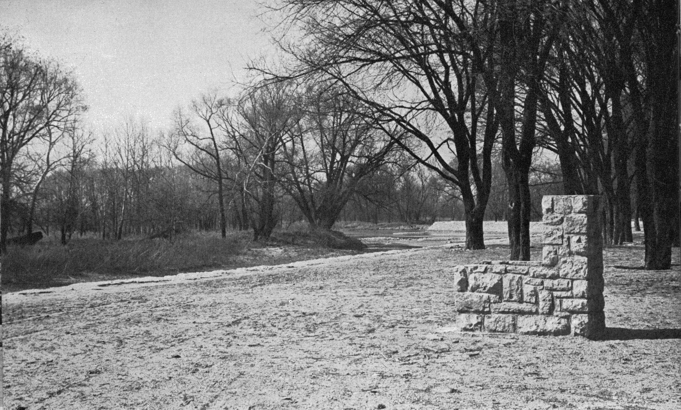 I assume this late 1930s picture was taken somewhere along the Olentangy River in the area of Clintonville. Note that both the trees and the stone structure are actually in the water. Does anyone out there recognize the location? [From a North High Memory Book]

Libby Wetherholt recently gave this presentation about the Zimmerman family to the Clintonville Historical Society, and has kindly agreed to share it with us.
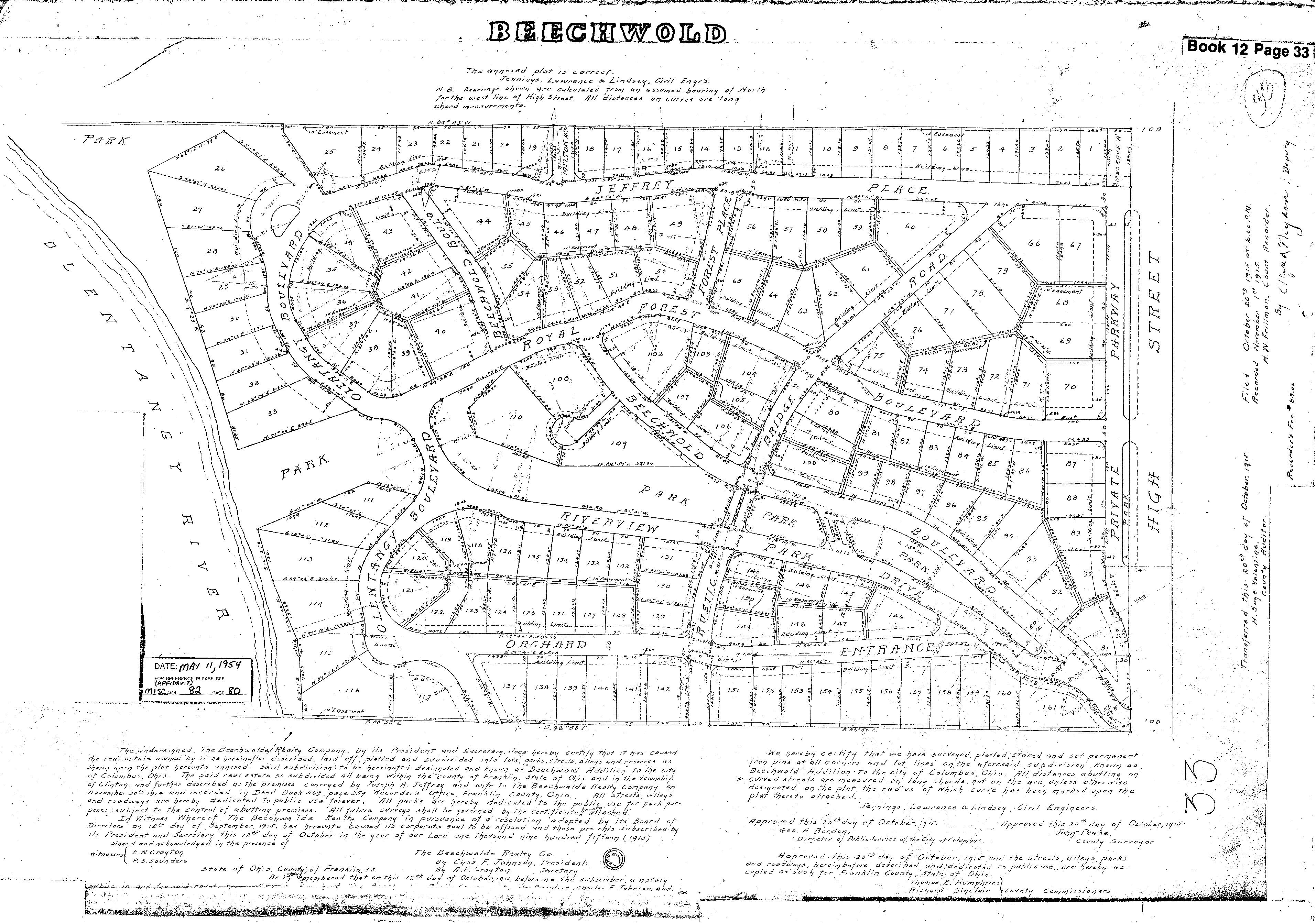 Wendy Bayer sent us this wonderful plat map of Old Beechwold. Plats are maps, usually drawn to scale, of the subdivisions of a piece of land. with lot numbers. [Map courtesy of Franklin County Records via Wendy Bayer]
Ron Irick recently alerted me to the Historic Marker Data Base. In it are photographs of several additional markers covering Clintonville’s notable people, places and events. The database includes the marker for Rand Hollenback, on Hollenback Drive at Whetstone Park, the Nat’l Register of Historic Places marker for East North Broadway Historic District, and the marker (currently in Powell) for the Grand Carousel which was formerly at Olentangy Olentangy Park.
Ron recently posted the Clinton Township/Clintonville Historic Marker.
Though not in this database, there is also a marker for the Old Beechwold Historical District. I believe there is also some sort of marker for the former home of the Republican Glee Club at 57 Weber Road.
Kevin Parks has written a very nice article about Clintonville Historical Society’s new Historical Markers program in the March 22, 2016 issue of This Week/The Booster
Despite his lead sentence, full credit for the program belongs to Mary Rodgers, not me! Mary has done a superb job of harnessing Clintonville’s community energy to get things done, history-wise, in the neighborhood. Thanks, Mary!
And thanks, Kevin, for publicizing this program.
[My post on the topic of markers–the one to which Kevin refers in his article– can be found here. I have recently revised & updated that post.]
You are currently browsing the Clintonville & Beechwold blog archives for the year 2016.