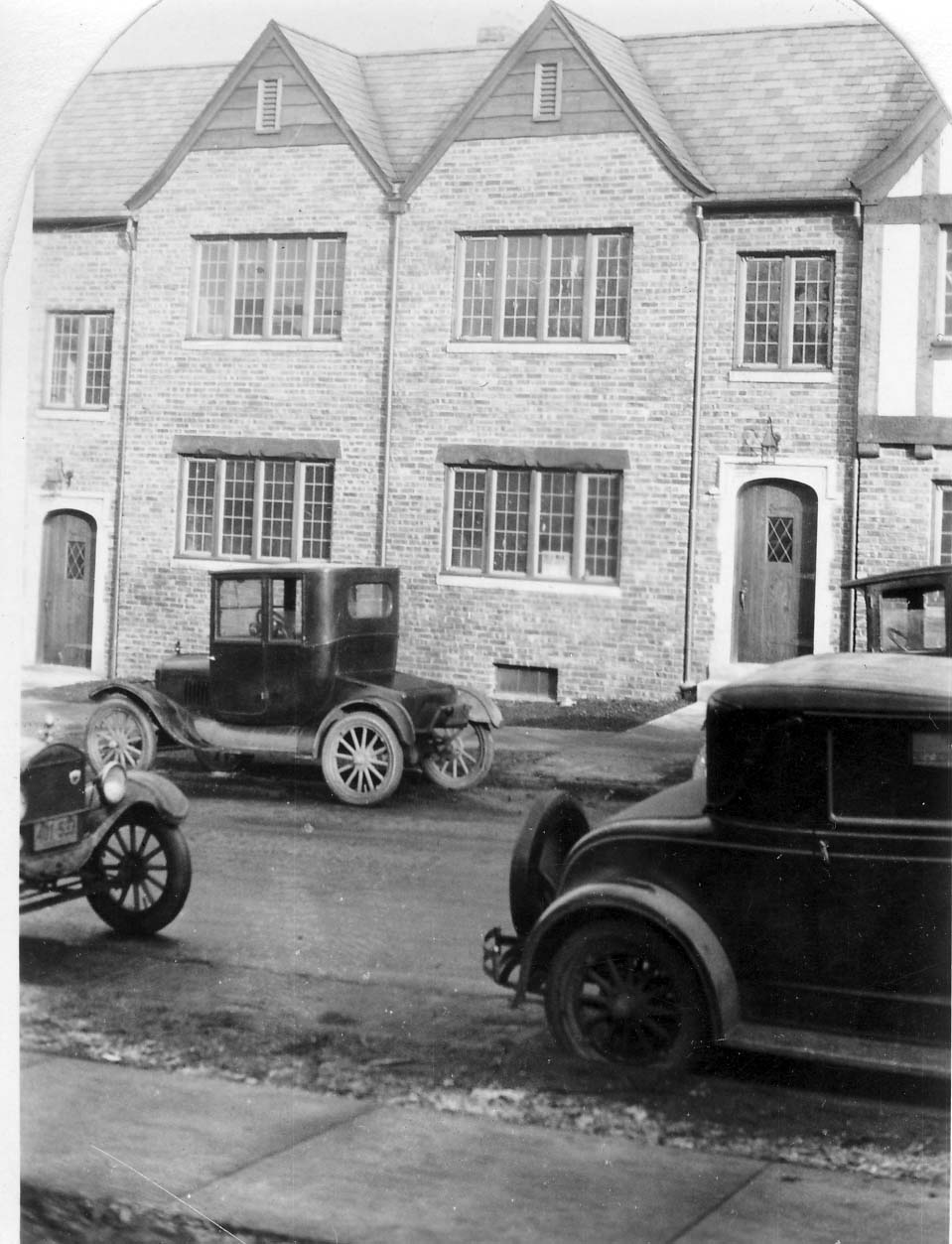
Oakland Park & N High, 1922
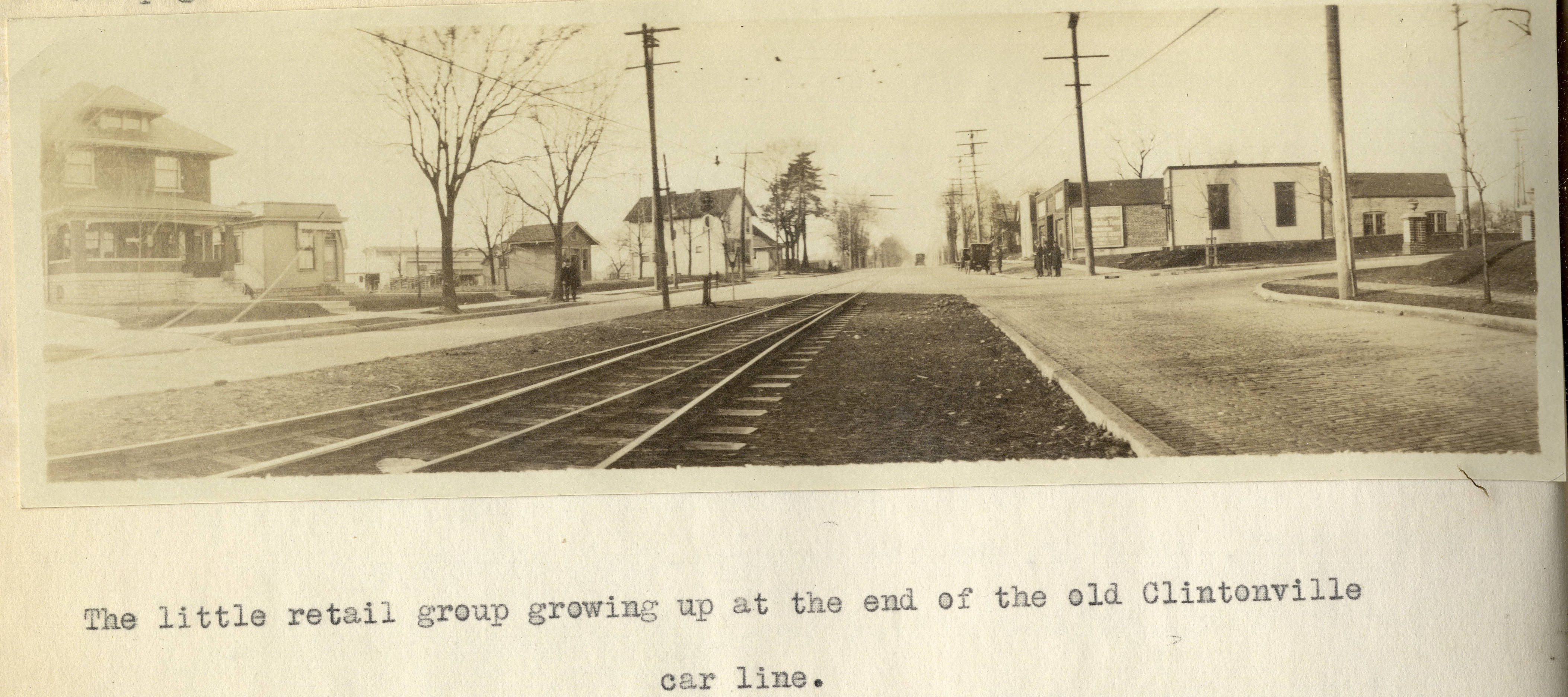
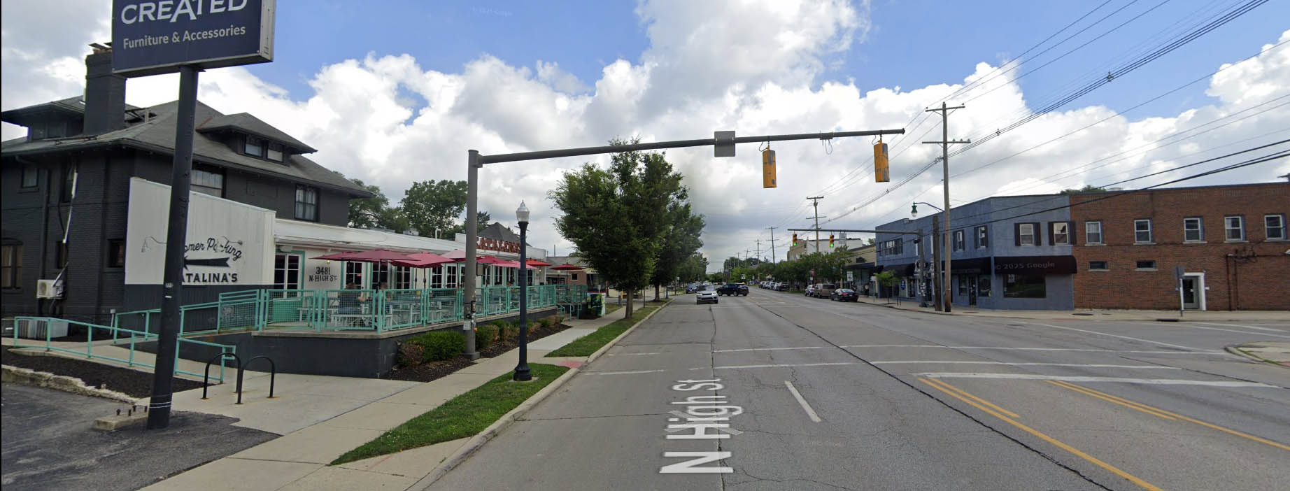
I’ve previously mentioned Forest Ira Blanchard’s wonderful master’s thesis, which is a treasure trove of photos of Columbus in 1922. It contains this old photo of Clintonville at the intersection of Oakland Park and North High in 1922. The house on the left, west, side of North High Street is still with us! Here’s that same intersection today.
Here’s Blanchard’s accompanying text:
Beyond Hudson Street to Arcadia Avenue, High Street is about solidly lined with small, but unattractive store rooms, this being the business section of the old, formerly outlying, hamlet of North Columbus. Here, at the corner of Arcadia and High is located the car barn and the end of the High Street car lines. Until recently, from this corner, through Clintonville, the Clintonville line and the Columbus, Delaware and Marion Interurban cars furnished the transportation service; now, the former line has been superseded by an extension of the Summit Street line. At the center of the former suburban village of Clintonville , where Clinton Heights Avenue joins High Street a small retail center has grown up, which is extending northward on High Street , a short distance . At the end of the Clintonville car service another little business center is coming into existence, incidentally the cross street here, Oakland Park Avenue , is a through one into the country to the east . This point not only ends the city car service out North High Street , but the retail stores as well , which is instructive as to the influence of such transport service upon the location of retail stores.
Such residences as are yet found along the High Street electric lines are not as good, on the whole, as those back of them away from the noise of the cars .
Alex Campbell has kindly provided a bit of background information on the transportation systems mentioned in Blanchard’s document:
When the line north of Arcadia was trackage for the CD&M, up to about 1922, it was single track from Arcadia to Tulane Rd than double track to Kenworth Ave. From Kenworth Ave north, it returned to single track with four passing sidings located between Kenworth Ave and Worthington. Between Tulane and Kenworth, the double track was in the center of High St. separated from the paved road. I’m not sure what you call that – a boulevard?? (I suspect you know all this. I just wanted to be on the same page.)
This drawing of the 1925 CRP&L Co. trackage by BJ Kern is what I am using to back up what I’m describing.
In Blanchard’s photo, the end of the double track is visible, which indicates that we are either at the north or south end of the double track. If it were the south end, you would expect to see more trees and maybe even Olentangy Park in the distance – it’s not the south end. That leaves the north end of the double-track.
Oakland Park tees into High Street from the east. The fancy and inviting brick columns suggest the developers have been busy. Kenworth would come from the west, slightly south of Oakland Park, if it even gets as far as High Street. In either case, it isn’t visible.
Blanchard refers to this photo location as “the end of the old Clintonville car line.” I think he is referring to the predecessor of the CD&M, the Columbus, Clintonville & Worthington Street Railway. The double track section must have been built by the predecessor, not the CD&M. The CC&W was itself the joining of two traction lines, and this is where the two joined.
Thank you Alex!
[Courtesy of Forest Ira Blanchard, An Introduction to the Economic and Social Geography of Columbus, Ohio. Thesis (M.A.), Ohio State University, 1922, page 38. Blanchard lived from 1886 to 1963.]3141 Silver Drive Looking North

This is a nice photo from a 1922 Ohio State University masters thesis by Forest Ira Blanchard. I believe, based on the metadata, that it was taken at 3141 Silver Drive and the panorama photo is captioned, “Possible industrial sites along C.A. and C.-looking north” [i.e. the Cleveland, Akron & Columbus Railway]. The houses that you see to the left (west) of the railway tracks may well be East North Broadway.
There is a white pole near the tracks on the right side. That would be the whistle sign letting the engineer know it’s time to start his whistling for the crossing ahead.
Blanchard, inspired by the Chicago School of Sociology, sought to study the racial and ethnic composition of the city of Columbus, with a particular focus on the role of transportation (railroads, roads) in shaping the urban landscape.
[Courtesy of Forest Ira Blanchard, An Introduction to the Economic and Social Geography of Columbus, Ohio. Thesis (M.A.), Ohio State University, 1922; digital version from City of Columbus Historic Map Collection.]Glen Echo Beyond the Ravine

This is a nice photo from a 1922 Ohio State University masters thesis by Forest Ira Blanchard. I believe, based on the metadata, that it was taken at 2734 Indianola Ave. It is captioned, “Glen Echo section beyond the ravine.”
Blanchard, inspired by the Chicago School of Sociology, sought to study the racial and ethnic composition of the city of Columbus, with a particular focus on the role of transportation (railroads, roads) in shaping the urban landscape.
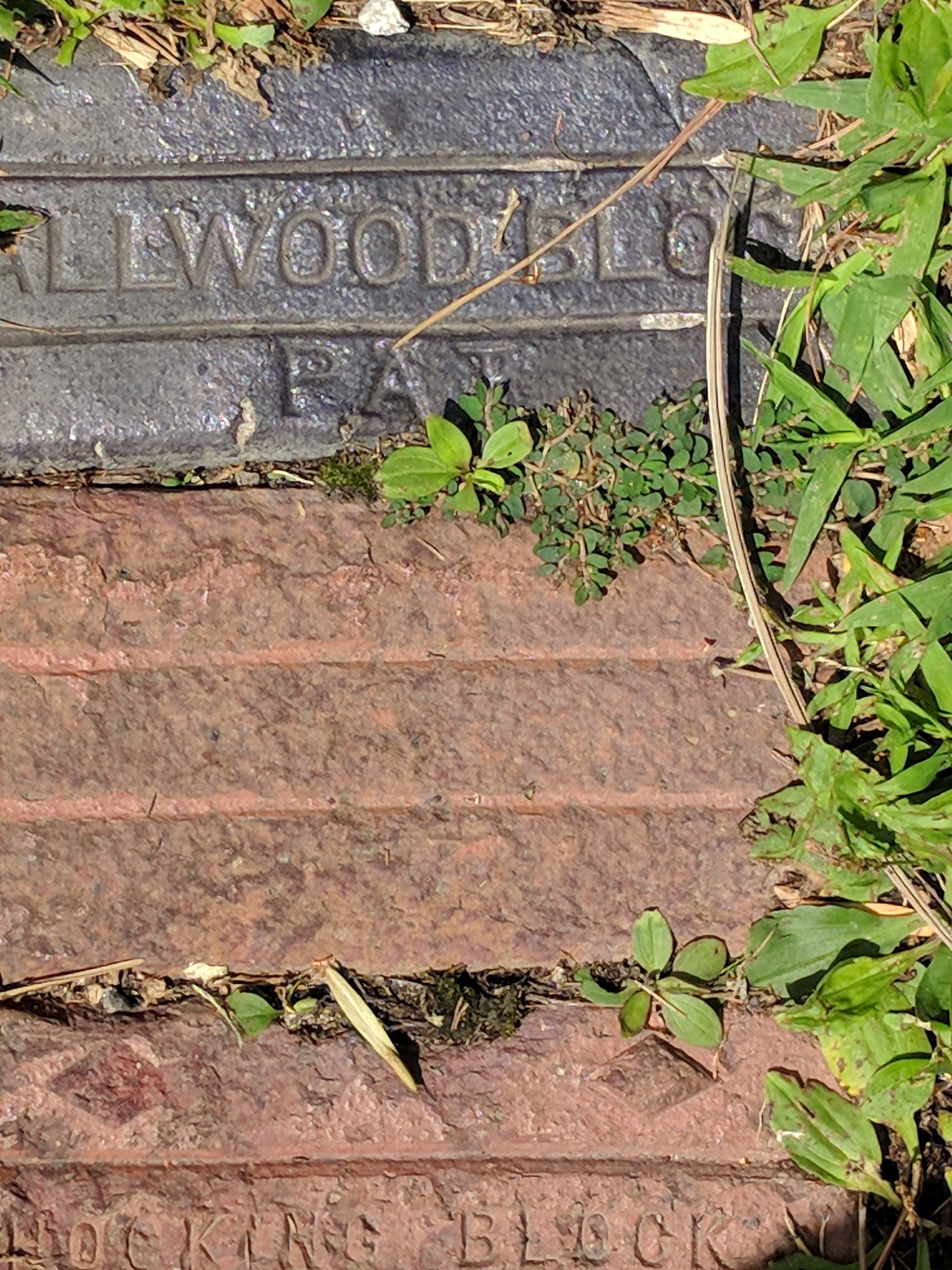
[Courtesy of Forest Ira Blanchard, An Introduction to the Economic and Social Geography of Columbus, Ohio. Thesis (M.A.), Ohio State University, 1922; digital version from City of Columbus Historic Map Collection.]Brick by Brick
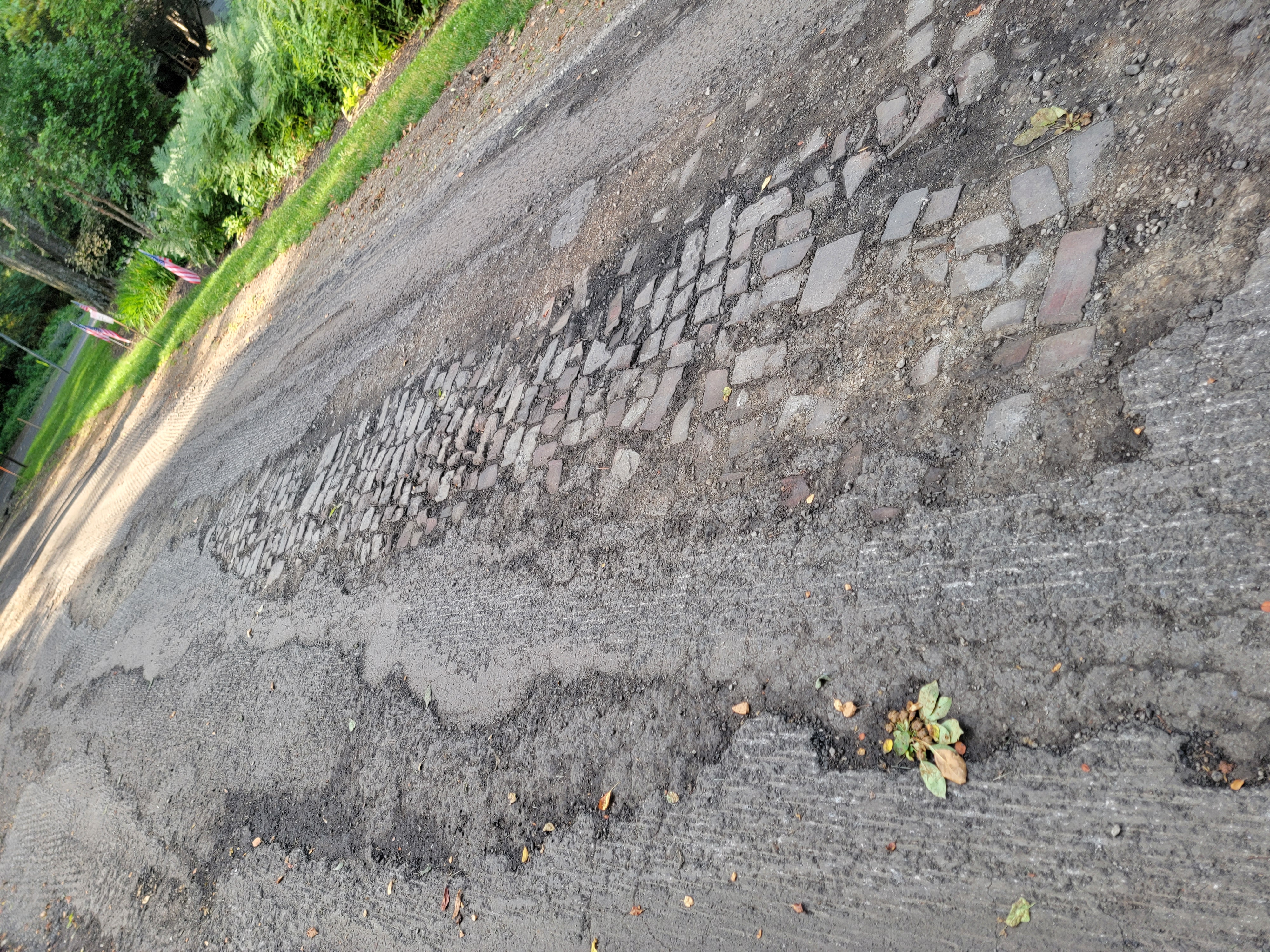
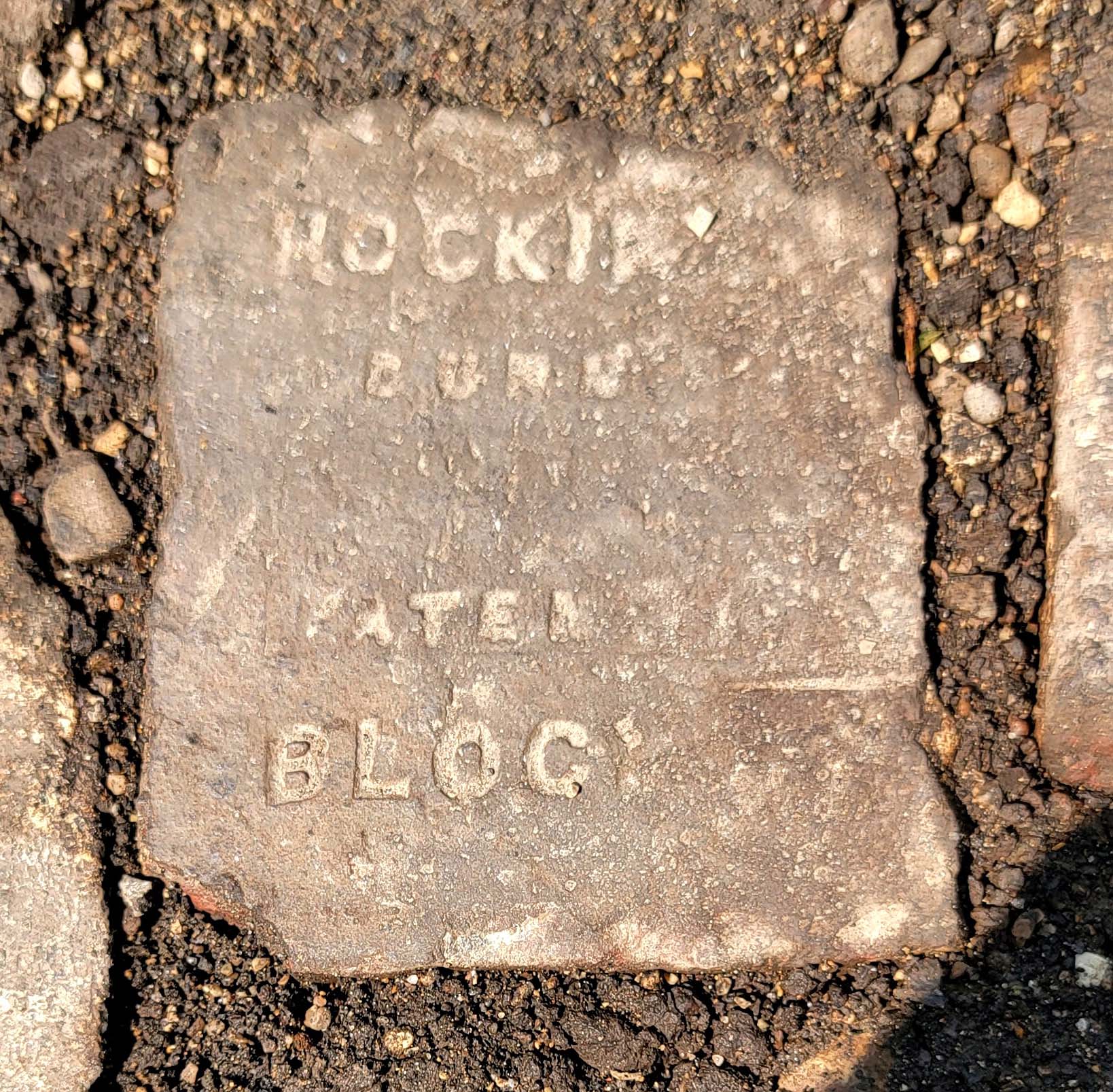
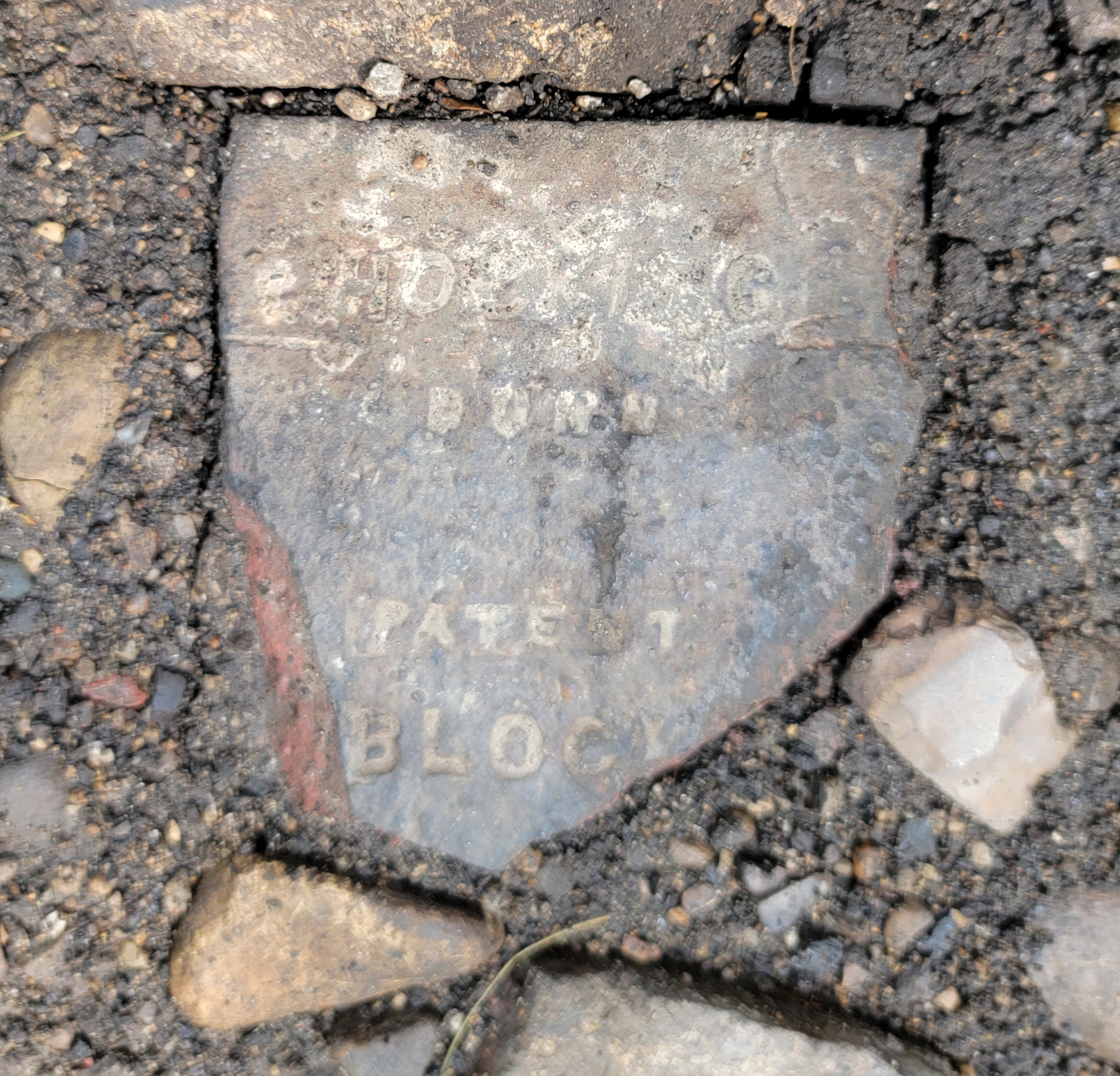
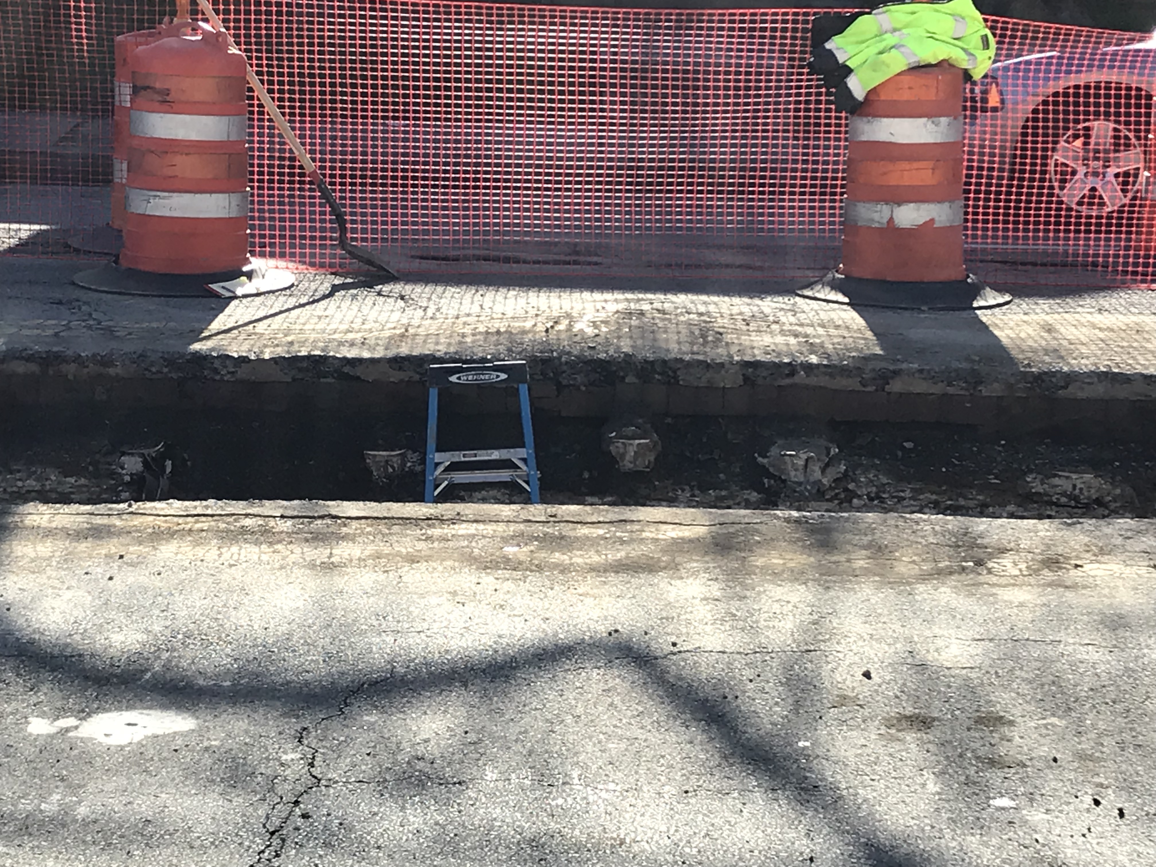
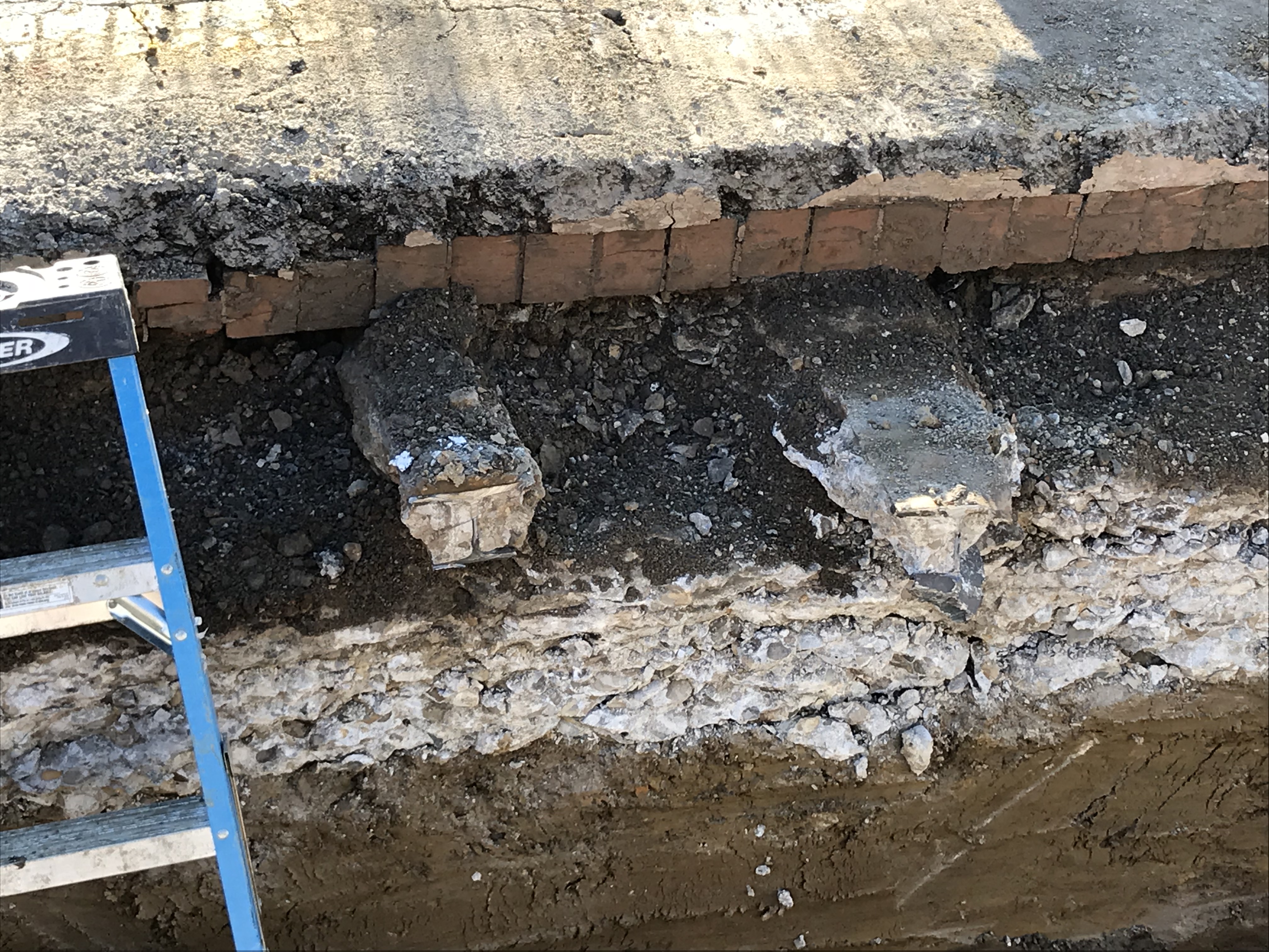
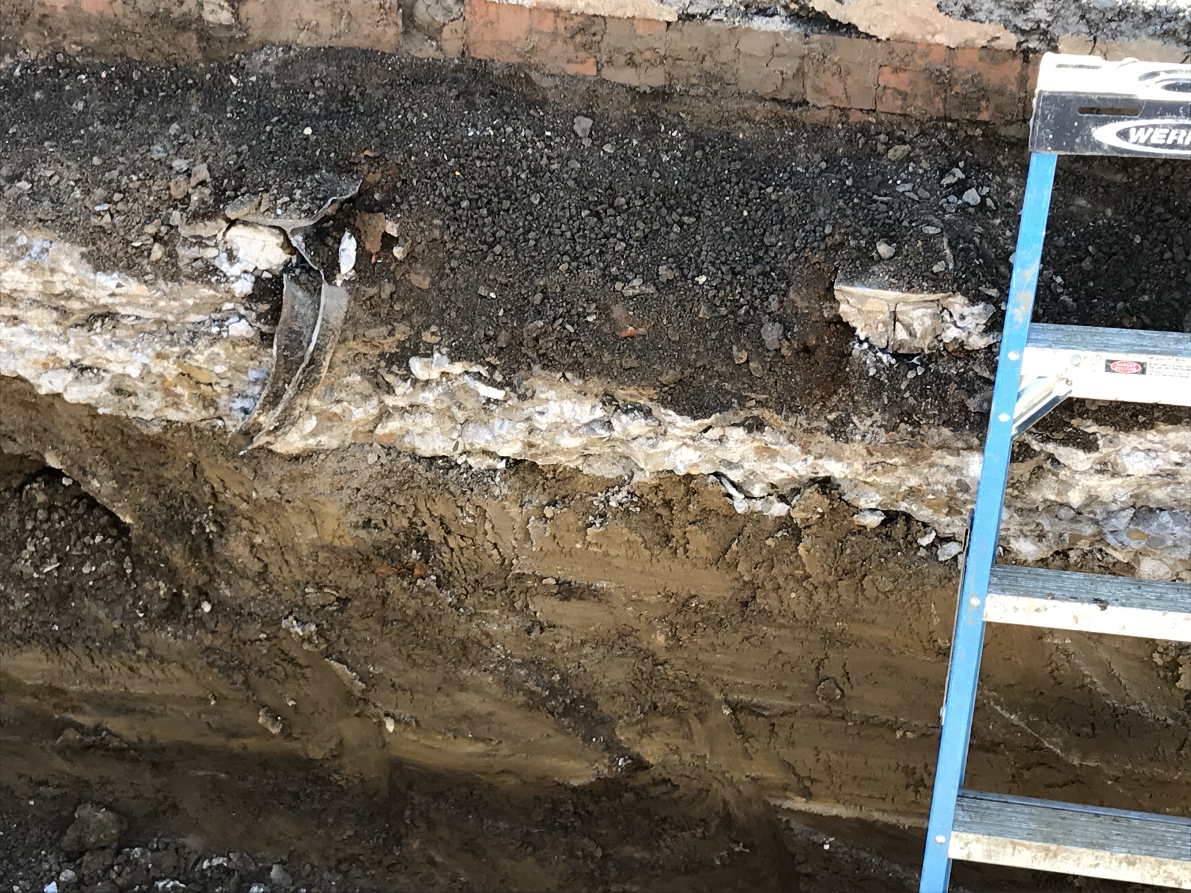
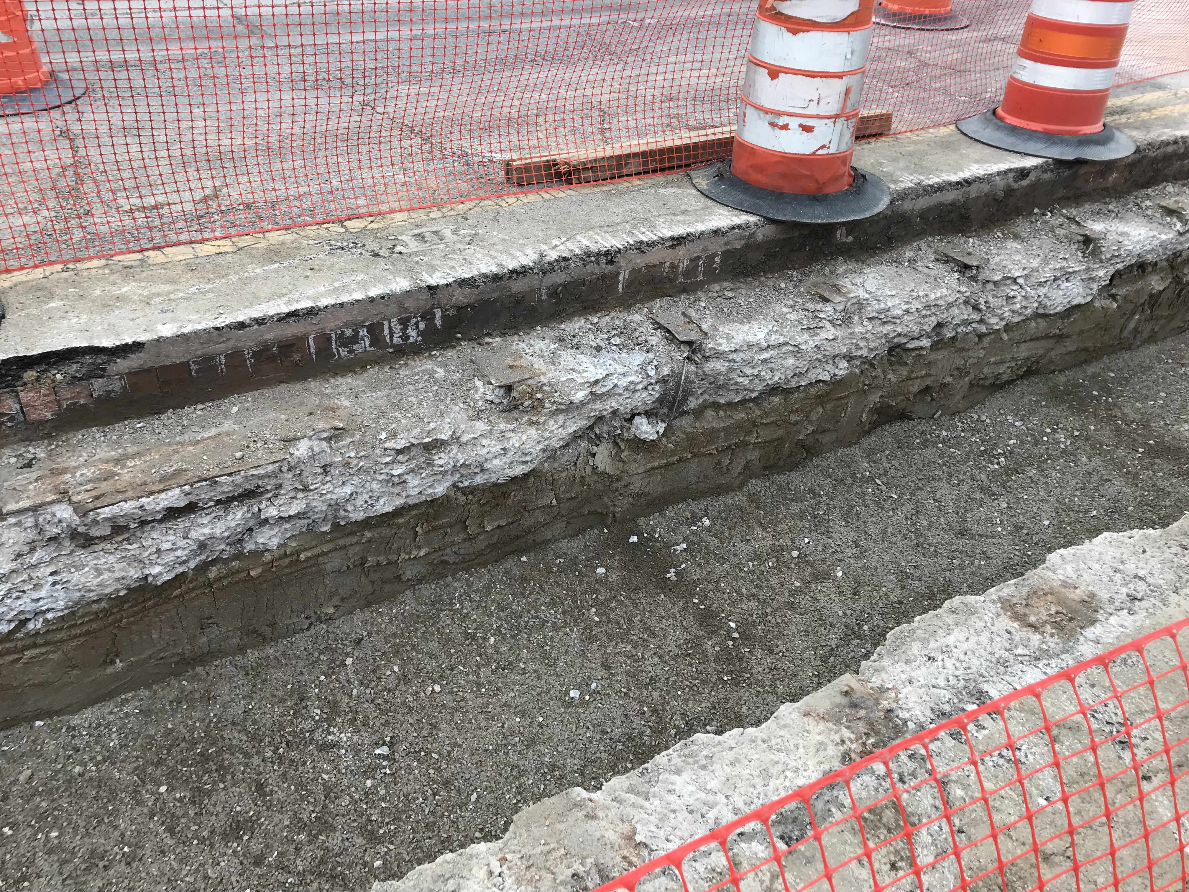
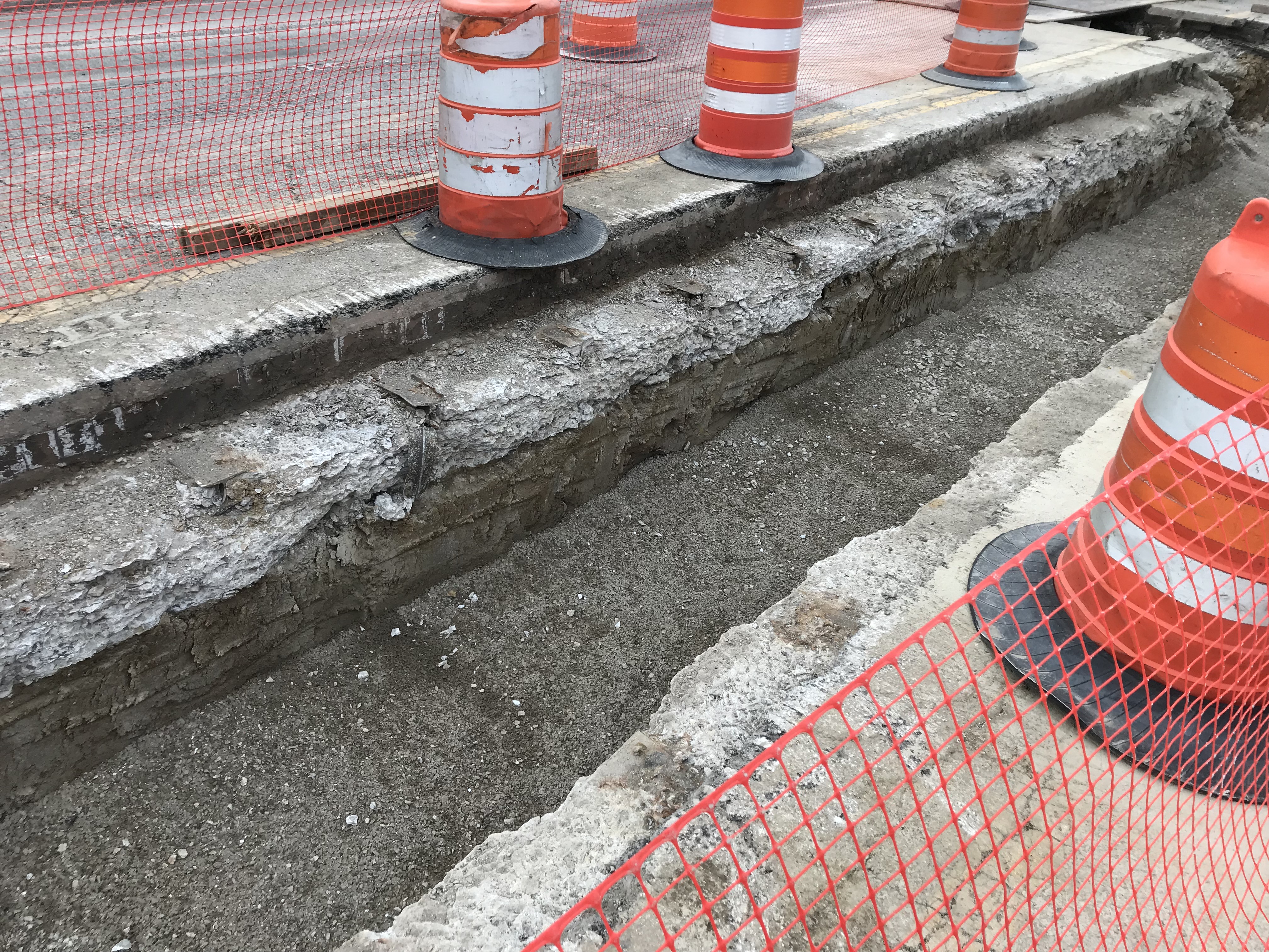
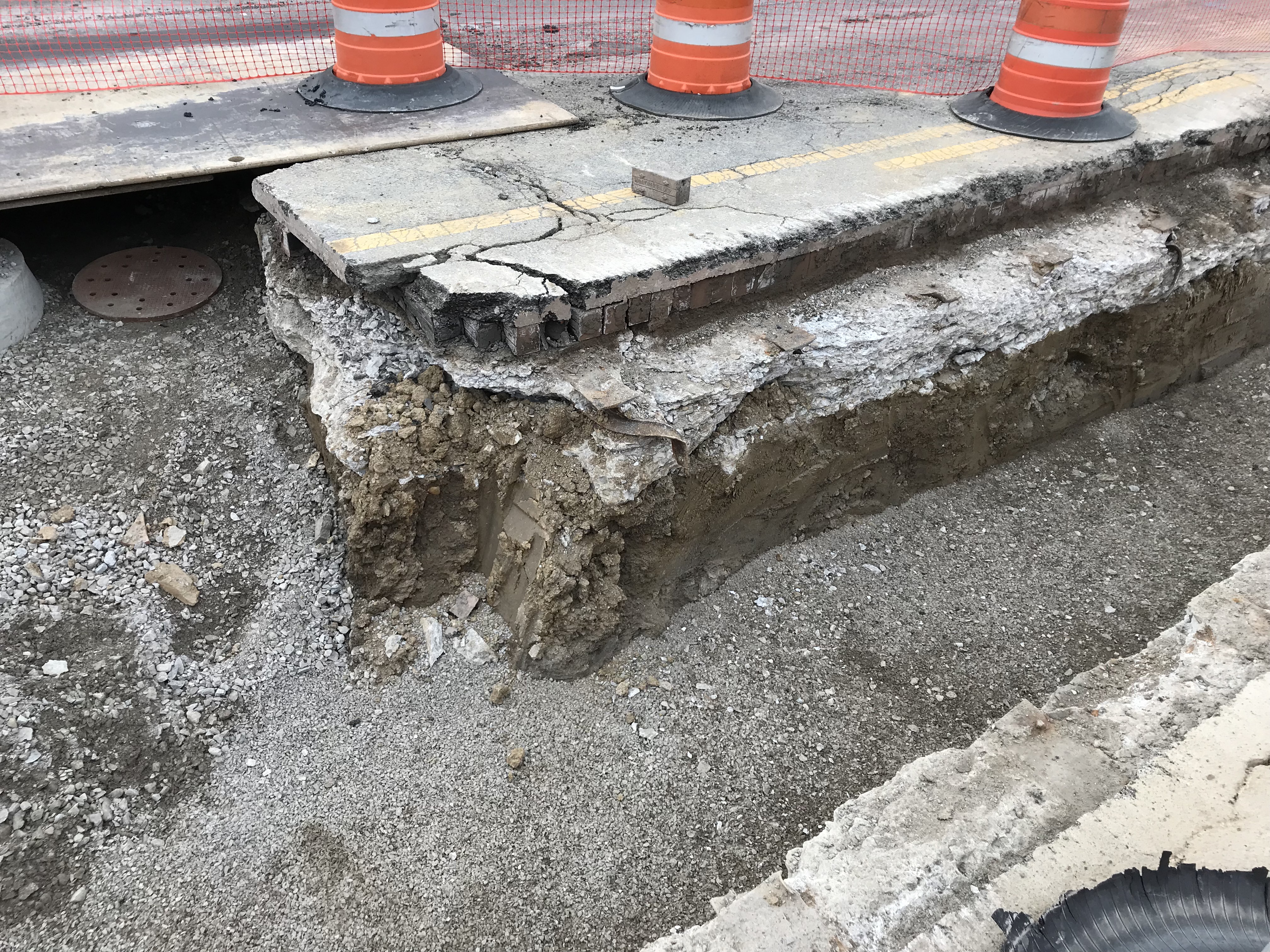
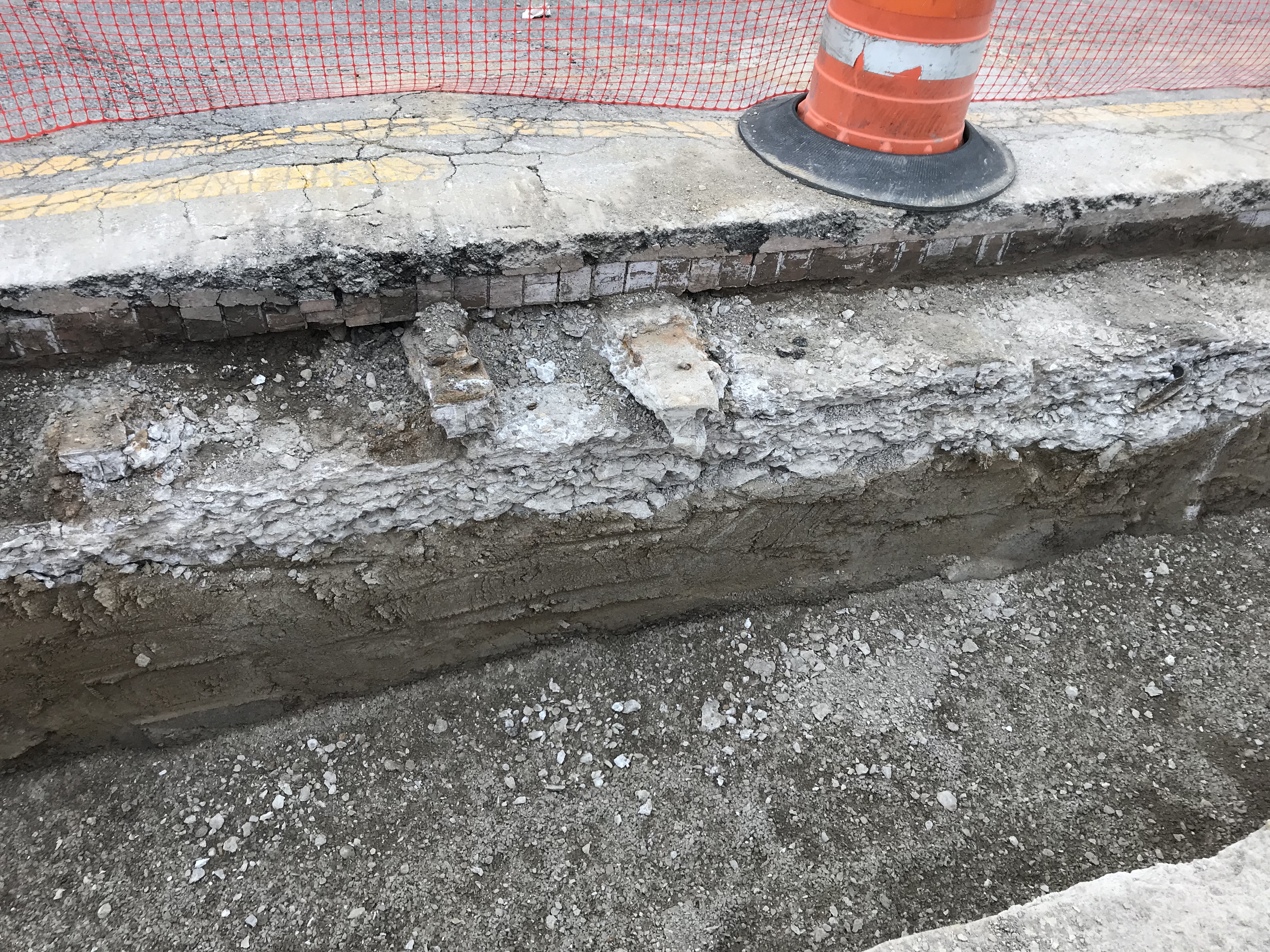
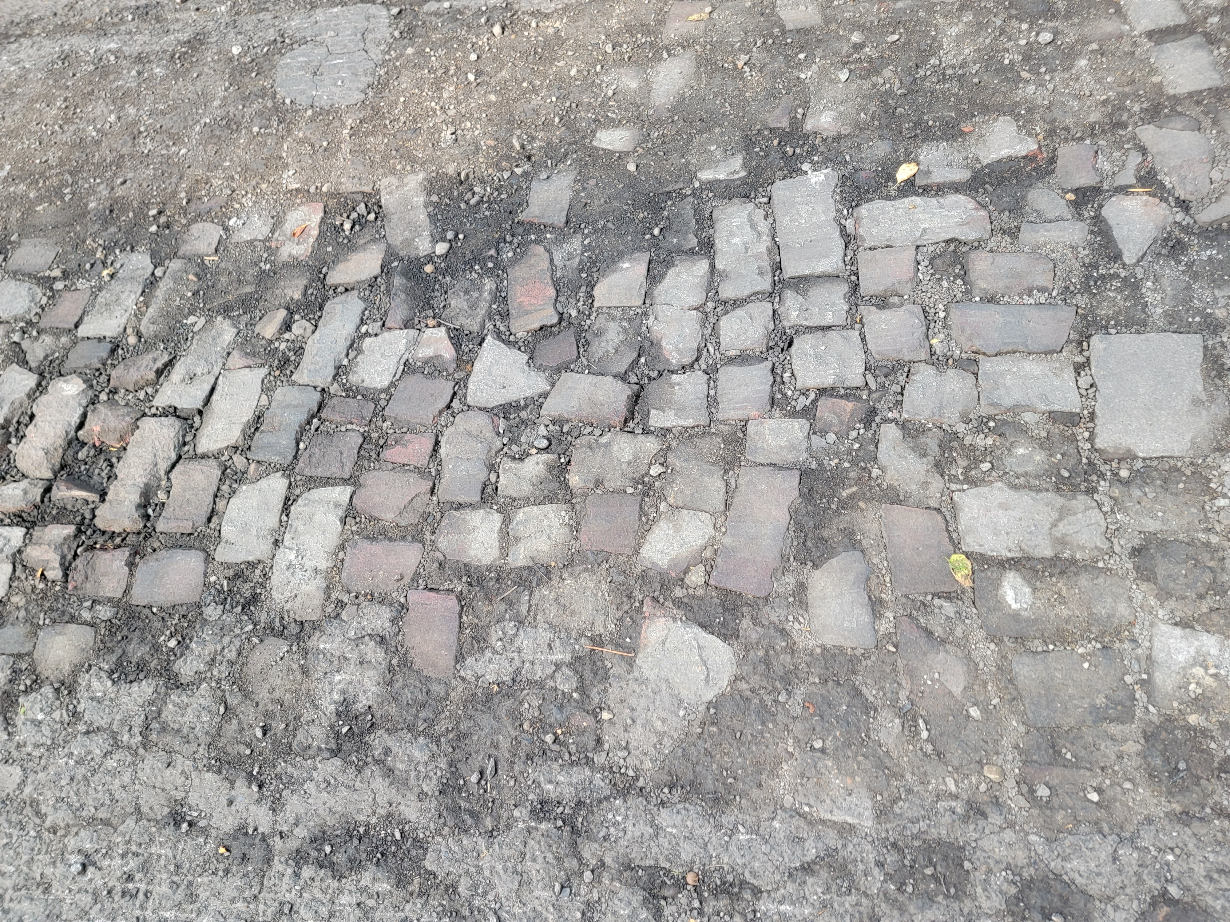 Katie Knostman has shared some photos of the old pavers on Olentangy Blvd at Rustic Place (near the driveway for 4783 Olentangy Blvd), exposed during the recent construction that the residents of Old Beechwold have been enduring.
On close inspection, two of the bricks say Hocking Dunn Patent):
And on the topic of bricks: Here is a photo of a brick that Clintonville Historical Society has in its archive.
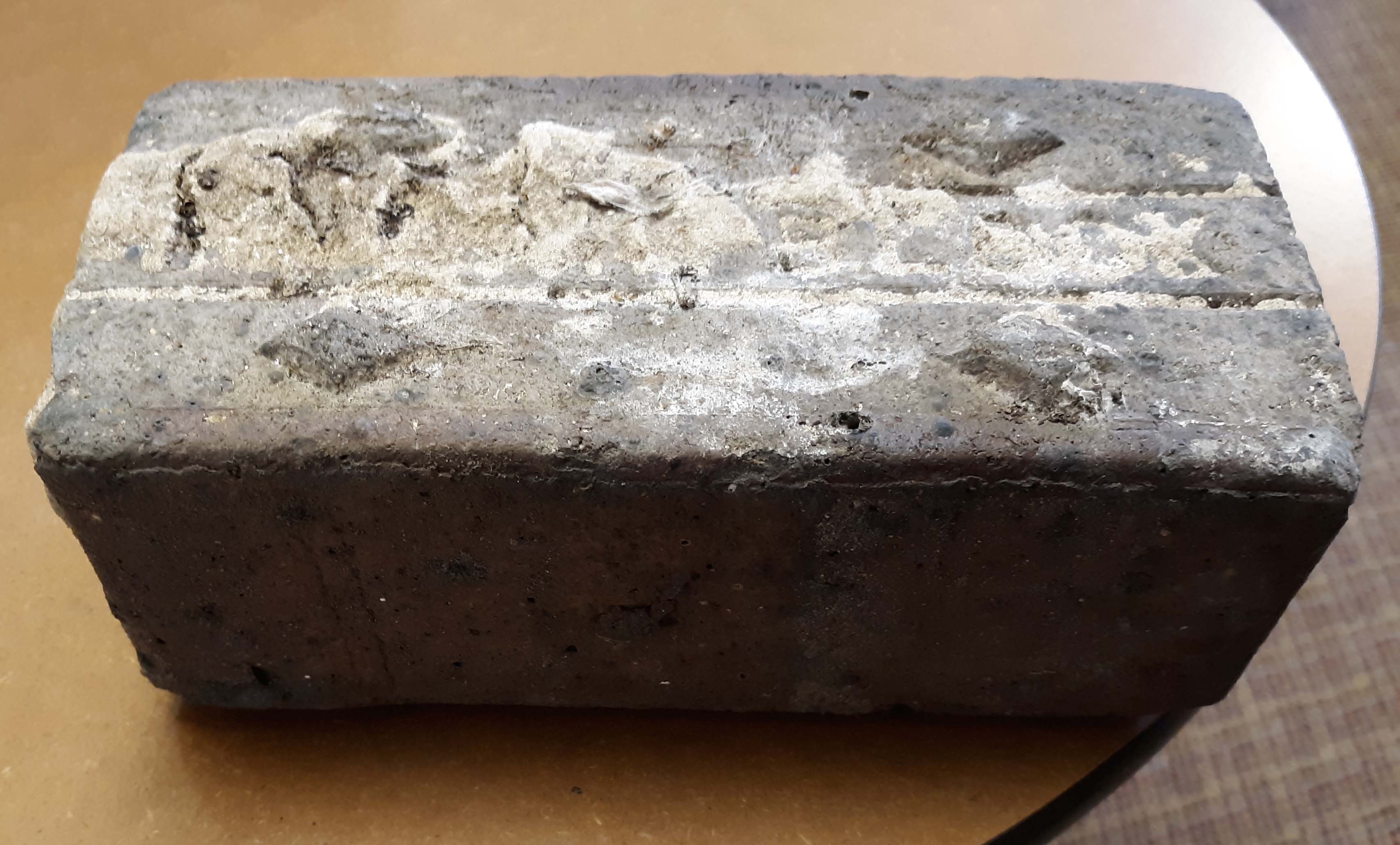
CHS actually has 2 bricks. According to Mary Rodgers: “These are the actual pavers from the street [near American Vitrified Products, which was located on the former site of North High School at Arcadia and Calumet]. The official name of the brick is covered in mortar. You can see the diamonds. Those keep the horses from slipping when the bricks are wet. We might try to remove the mortar from one. It is interesting. They are porous–lighter than I thought…I have seen some articles that are associated with the early use of site. William Wassell seems like an interesting character. They made pipe and bricks. Supposedly, this is one of their bricks. In the late 1800s, they made a fountain for the fairgrounds-all out of pipe. I would love to find a photo of that!” Here’s an article about the fountain.
And finally, a house on East North Broadway has many bricks lining the driveway. These may have come from that roadbed.
Flower Power
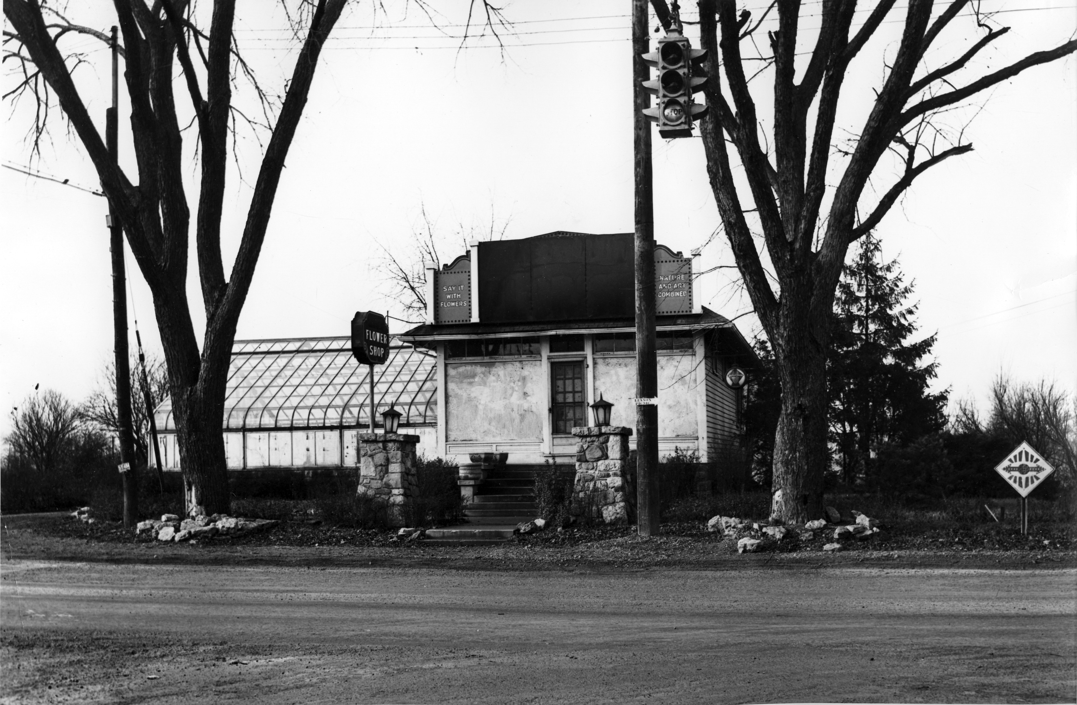 These lovely pictures are of the Albrecht Floral Shop at 2703 River (or Olentangy) Road–the intersection of Dodridge and Olentangy River Road, looking north.
According to librarian Cindy at the Columbus Metropolitan Library, the flower shop went through several hands in the 1930s.
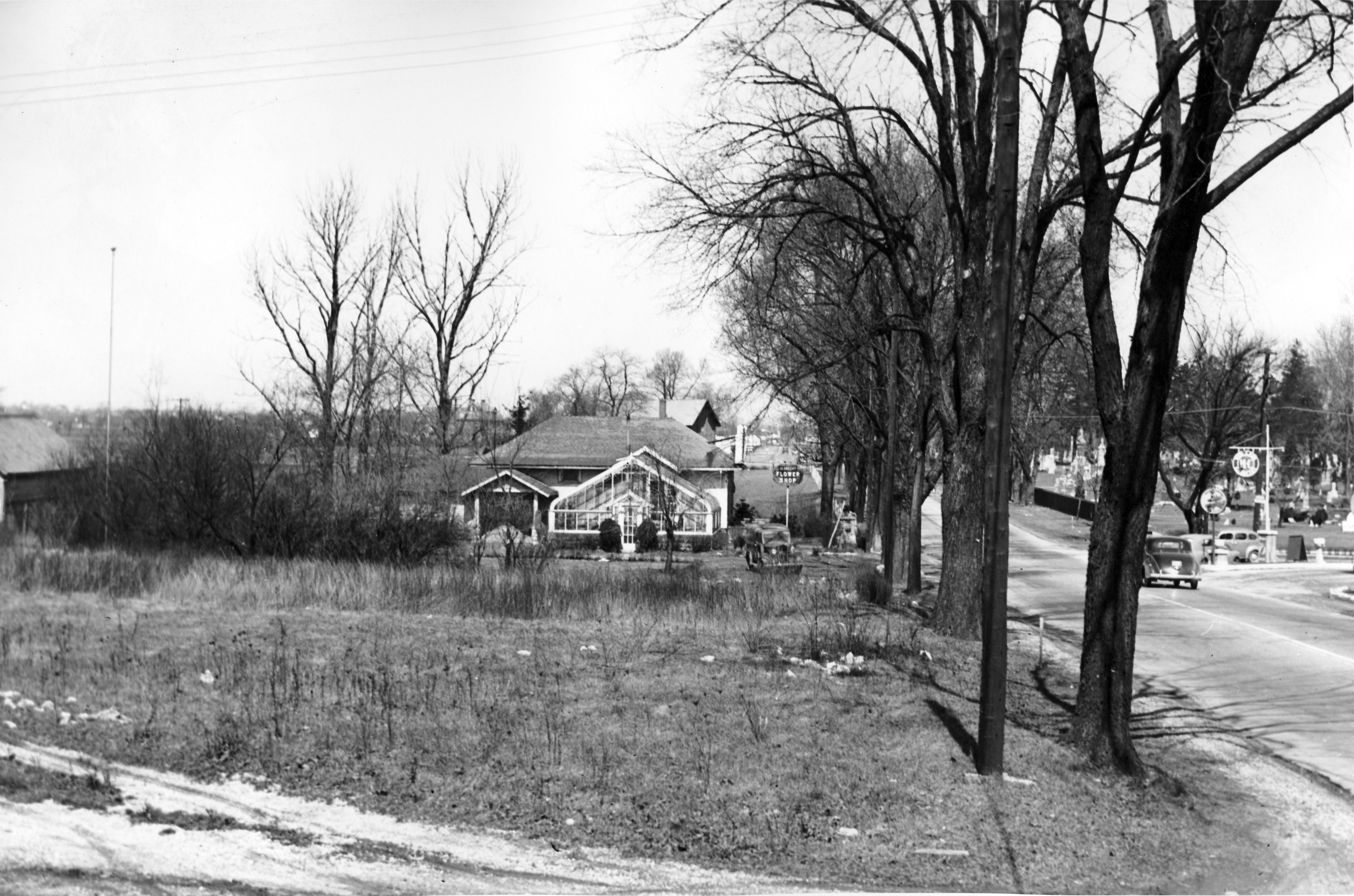
Cindy found a parcel sheet for what she believes is the property in question. The parcel sheet shows the greenhouse listed as well as a brick building.
 There is an ad for Flora Louise Hess, Florist in a 1925 Columbus Women’s Club cookbook that features an illustration of the building matching these photos.
Flora Hess sold the property to the state in 1932. She lived in a house close by at 2637 Olentangy River Road, however. In 1968 Johnny Jones wrote an article about an antique sale at the Hess homestead.
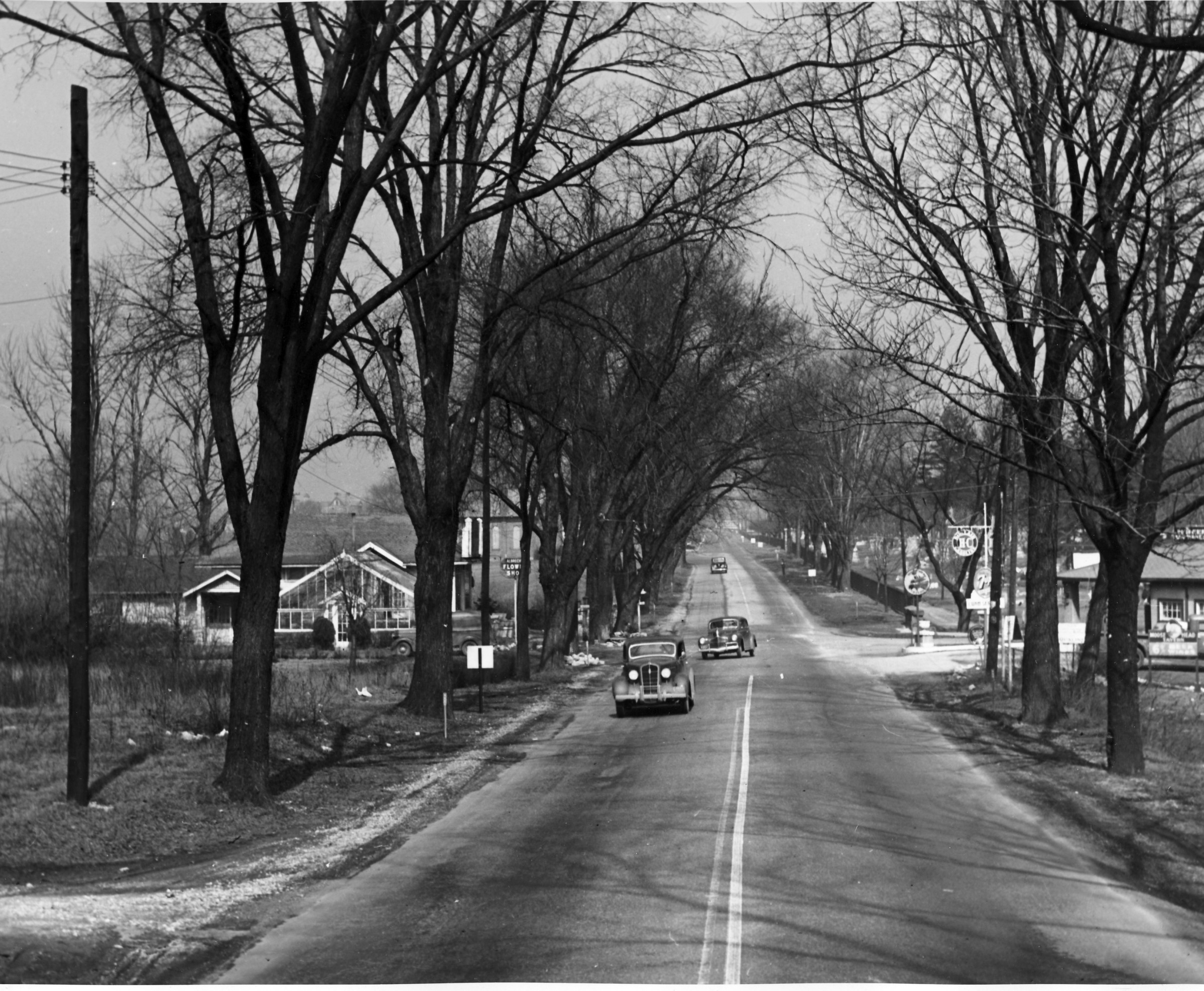 Across the street from the flower shop is a gas station. The Moosehead Filling Station and Moosehead Tavern was across the street at 2696 Olentangy Road as early as 1937. It advertised selling H-C gas; H-C was the first high-octane gasoline. In 1926, Sinclair leapt ahead of most of its competitors with H-C, the industry’s original high-octane premium gasoline for motorcars. The 72-octane auto fuel, developed at its Houston refinery, was better than anything then marketed (Lindbergh’s flight to Paris the following year was on 73-octane gasoline). H-C stood for “Houston Concentrate,” though some advertising men called it “High Compression.”
The Moosewood Tavern was apparently a trouble spot; this Columbus Dispatch newspaper article documents one incident of rowdiness.
[Photos courtesy of the Franklin County Engineers. Articles are from the Columbus Dispatch. Research on these photos and news items mostly came from Cindy at the Columbus Metropolitan Library Local History & Genealogy Desk; thank you Cindy! ]Olentangy Park, from Alex Campbell
Transportation expert and collector Alex Campbell sent along some Olentangy Park pictures. Though you may or may not have already seen these pictures, Alex’ knowledge is invaluable. From Alex:
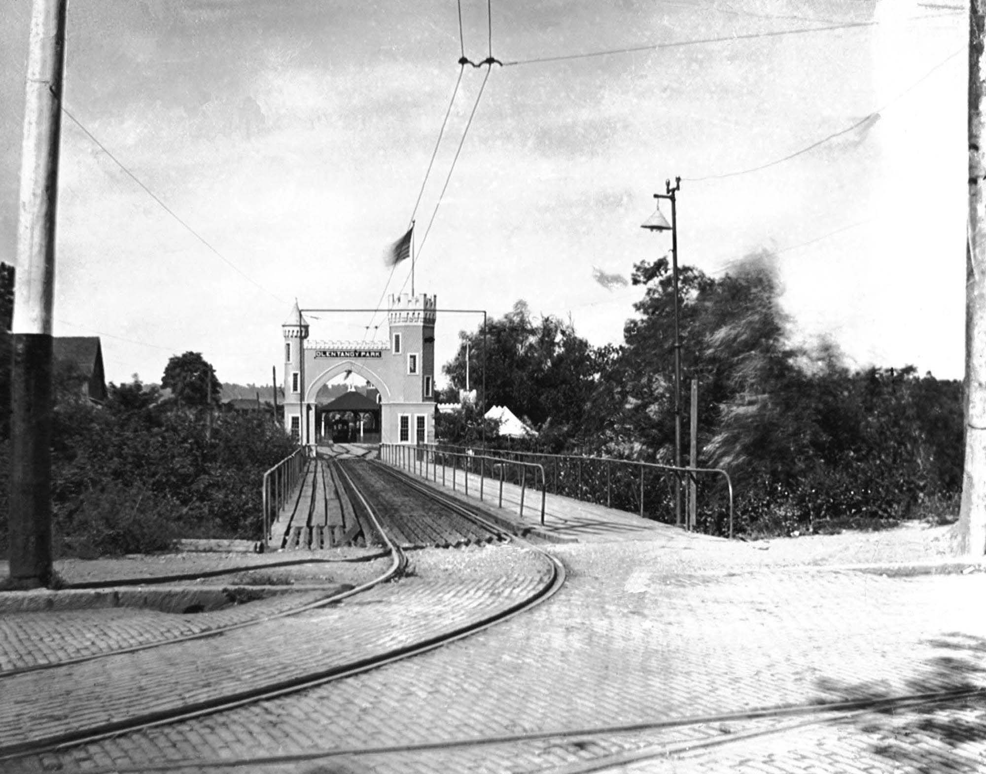
This is the streetcar and pedestrian entrance to Olentangy Park. Olentangy Park was purchased by the Columbus Railway & Light Co. in 1897 as a way to generate business. The high Street line ended at Arcadia. The North High Streetcar house was on the northeast corner of Arcadia and High Streets and directly across the street this park entrance. The Clintonville–Worthington streetcar line terminated at Arcadia as well hence the need for the pedestrian walkway.
Glenn Echo ravine runs east-west along the north side of the ravine. Crossing under the bridge is a north-south ravine that paralleled high Street. More on the north-south ravine on Wednesday.
The single track branches into two tracks, perhaps a loop. There is a loading platform beyond the arch. The single track into the park is going to be unsatisfactory as you will see on Wednesday.
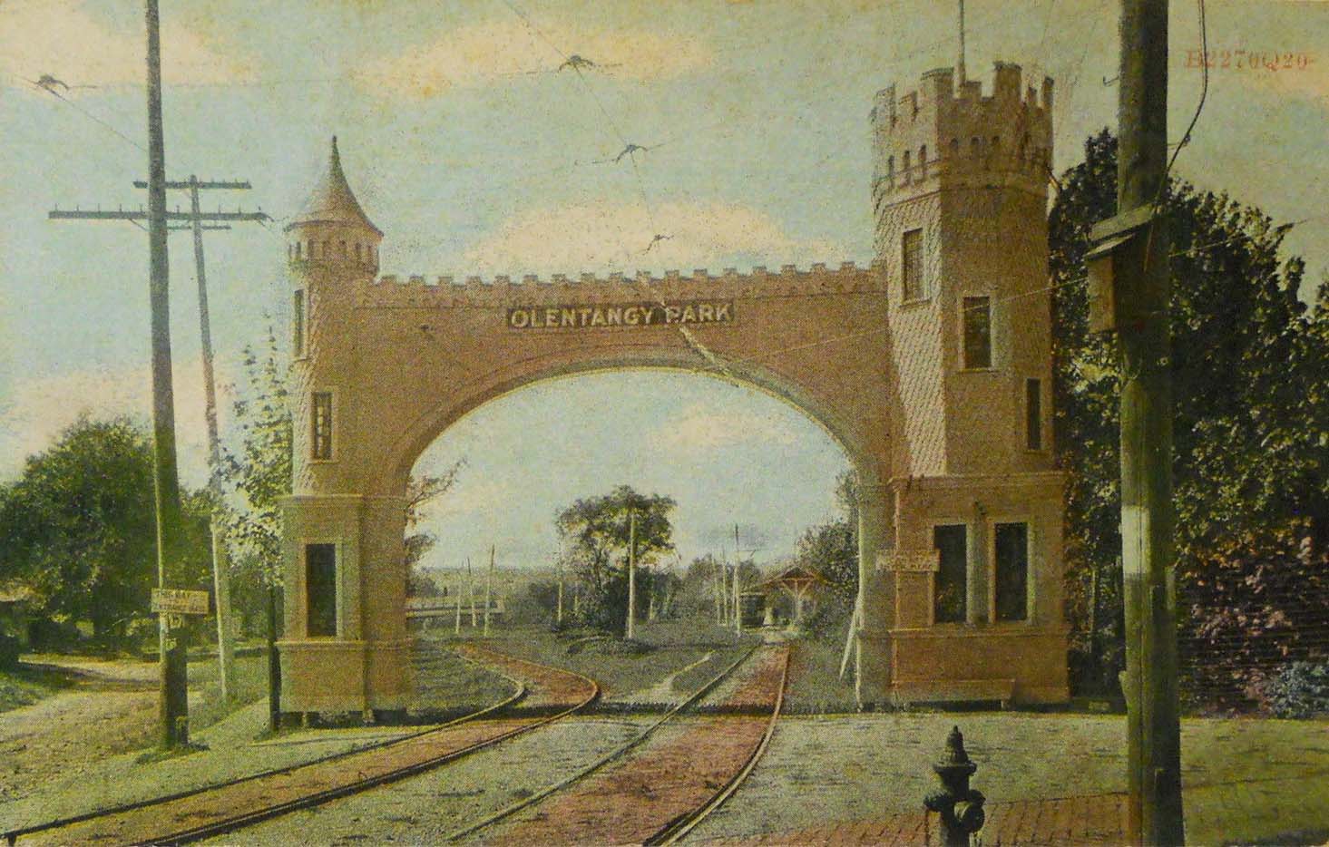
In 1907 the streetcar entrance to Olentangy Park was rebuilt. The ravine paralleling High Street was filled in eliminating the bridge. The inbound and outbound cars no longer had to share a single track. The Clintonville-Worthington visitors still had to walk in using the gravel path to the left of the entrance. (The CR&L Co was wide gauge and the Worthington line standard gauge.)
In 1899 the CR&L Co. sold the park to the Dusenbury brothers who transitioned it from a nature park to an amusement park. The brothers also built a 2248 seat theater.
When the theater let out the surge of streetcar customers must have required tens of streetcars. If they packed the cars with 60 riders each they would need 37 streetcars. That may be the reason the company made the improvements to the park streetcar loop and terminal.
At 5 cents a ride they would have collected $112, good money since they paid so little to their employees.
Alex also put together a super helpful Olentangy Park Chronology as an aid in dating all the Park photos that have shown up in the last few years. (Ohiomemory.org has a number of good Park photos.) Many of the chronology dates came from websites–so they are susceptible to error. Still it does give a sense of the life cycle of the park.
[ca1900 photo from the Christopher Trumbull Collection, by way of Alex Campbell. Postcard postmarked 1909 from the Alex Campbell Collection. Chronology courtesy of Alex Campbell]Broadway, ever controversial
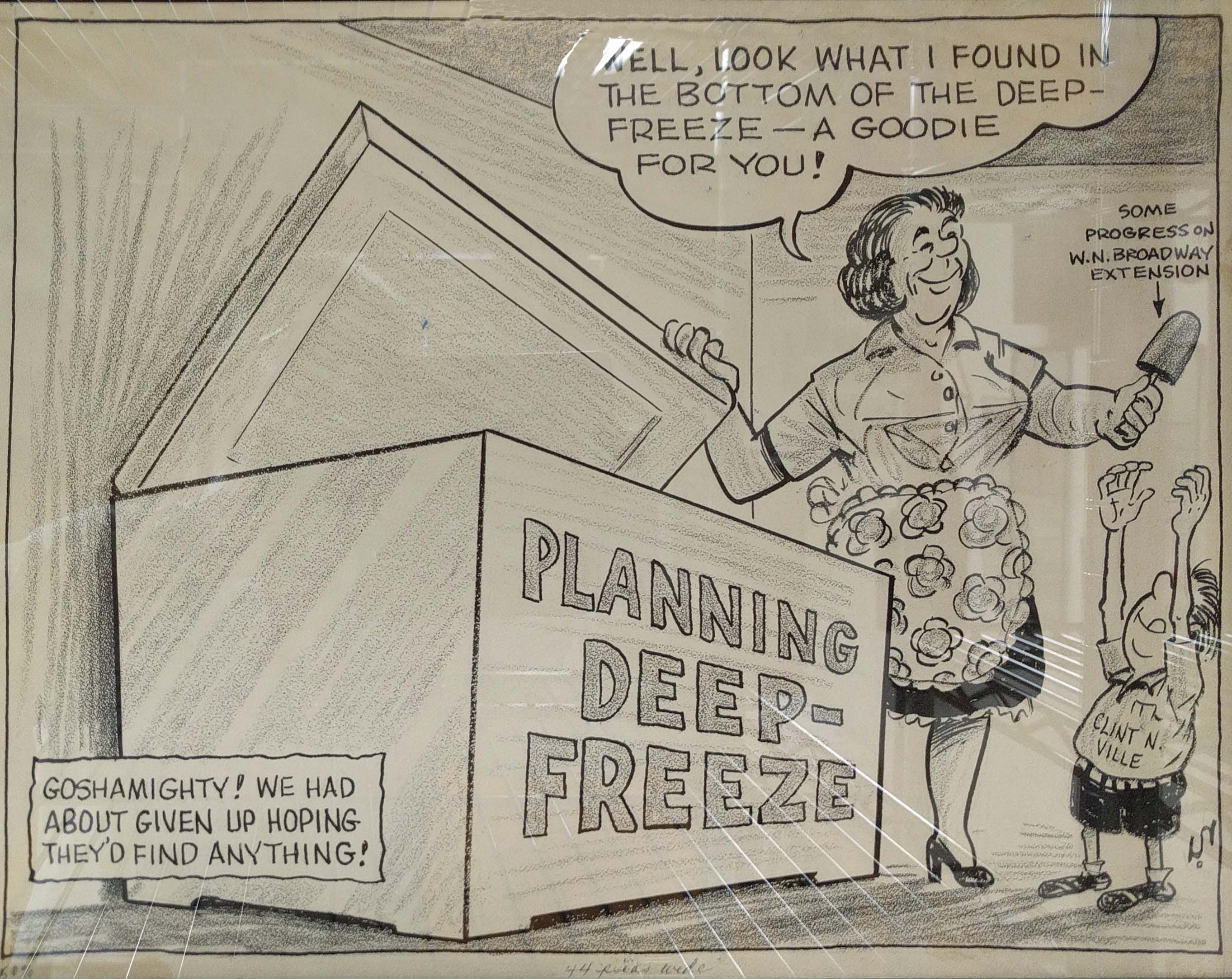 This is a political cartoon from the Clintonville Booster. The “Broadway Extension” involved extending North Broadway from Olentangy River Road westward to Kenny Road. It was a controversial and lightning-hot issue from about 1952 until the planned start of construction in October 1963, and well beyond.
Originally, residents of Upper Arlington objected to the extension, which traversed their city; and then it was realized that the extension would create traffic flow issues on Kenny and Fishinger both of which would need to be widened as a result. And eventually planning of the “Olentangy Freeway” (Rte 315) also entered the mix. It was on again, off again, with Upper Arlington approving then rescinding its approval several times. By the time the project got final approval, the designated federal funding had been tapped for other projects and so the extension was further delayed. I’m not sure what year this cartoon was published. I found an article that construction from Kenny Road to Clearview got underway in June 1966. In December 1968, there was a ribbon cutting ceremony for the extension.
It’s hard for many of us today to imagine North Broadway terminating at Olentangy River Road. Harder even to imagine Clintonville before the North Broadway bridge was built over the river in 1939! (In a nutshell: the bridge over the river was built 1939-40; United States involvement in World War II was 1941 – 1945, bringing most domestic construction to a halt; planning on this Broadway extension project resumes ca. 1952, ending well, I’m not sure when Route 315 was actually finished.)
[Image is from The Booster, and courtesy of the Hollenback Collection at the Clintonville Historical Society. I snapped a picture of the cartoon while it was still in the frame; apologies for the glare.]The Perennial Parking Problem
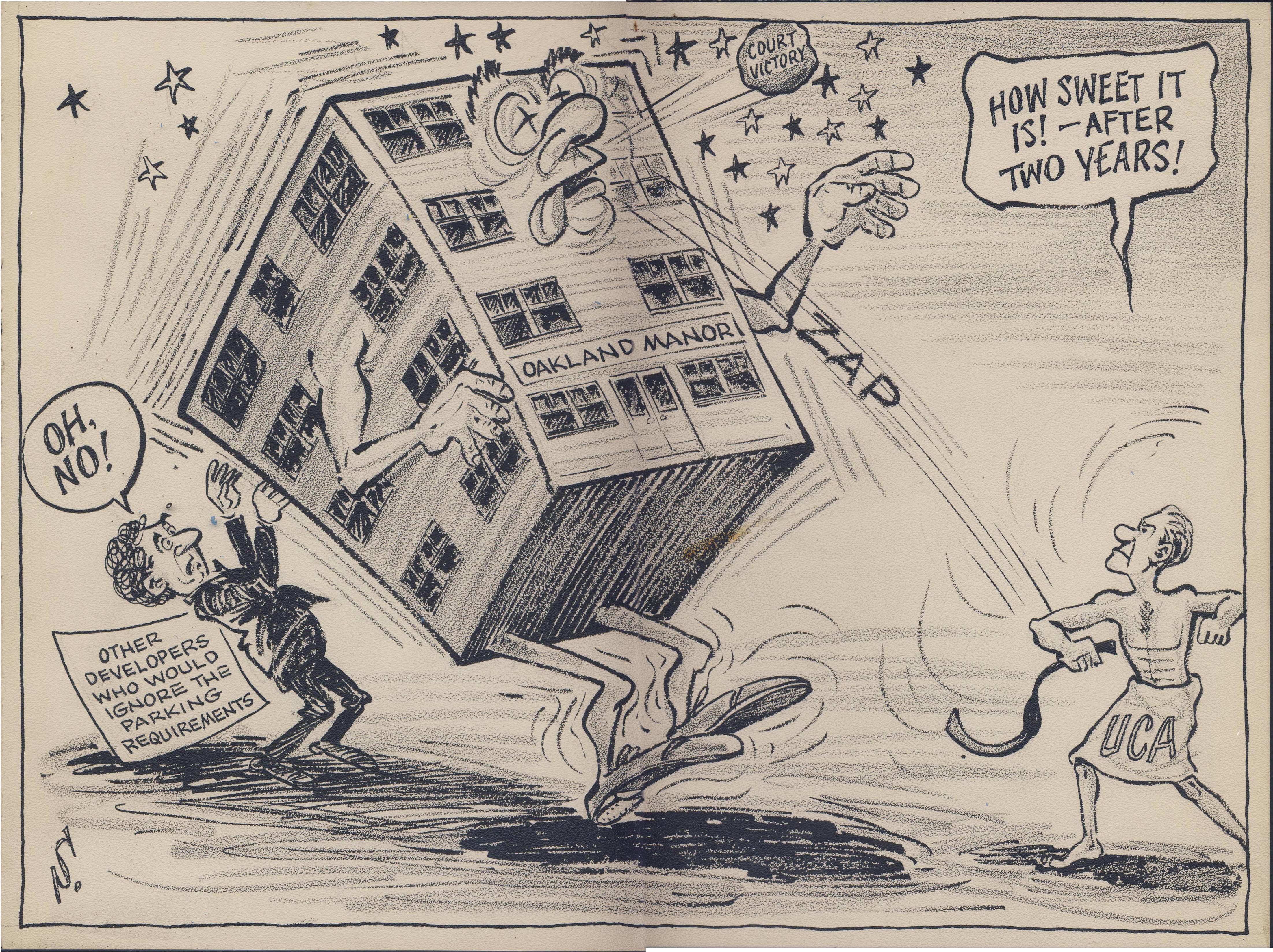 I really have no idea what this issue was all about! It’s an editorial cartoon from The Booster. Back in the late 1960s, Oakland Manor was the name of an apartment complex (with a swimming pool!) at 42-50 West Oakland Ave, 2 blocks north of Lane Ave. between North High and Neil Avenue. Currently I find an “Oakland Manor” on 1871 Oakland Park, in North Linden.
We may not know what the precise issue was, but we can guess that some scofflaw building owner tried to circumvent zoning regulations, and the community was not happy. Back in “the day”, The Booster played a very strong Clintonville advocacy role and this was undoubtedly an example.
[Image courtesy of the Hollenback Collection at the Clintonville Historical Society.]Hudson & Cleveland, or Elsewhere (Updated)
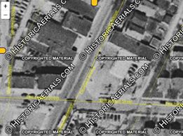
 This picture was labelled, in cursive, “Looking North at the Corner of Hudson and Cleveland.” It was obviously taken April 22, 1948 on State Route 3. The buildings in the photograph, however, don’t match the buildings that are there today–I’m especially eyeing that two story pre-WW II brick building on the left–so I’m doubtful it is that intersection. Any ideas about its location [Image courtesy of Galen Gonser.]
Michael Leyshon believes the photo may be looking south from Weber, where Cleveland/Westerville Roads split (see his comment below). Perhaps so! That intersection has an interesting corner curve, but I’m not convinced. I drove up and down the street today, and am not seeing that brick building (with its distinctive roof line) to the left in the photo. Travelling northbound from Hudson, between Hudson and Weber, there IS an old brick 2-story building on the west side of the street, that is now clad in white. That very old, virtually decrepit, building has the only roof line close in appearance, though it seems short compared to the building in the photo. I continue to welcome ideas. Thanks Michael!
See comments below. John Williamson reposted Galen’s photo to the Vintage Columbus–Linden Area Facebook Page, and asked those folks for their expertise and/or memories. Bob Roehrer found a 1953 aerial, shown below, that seems to confirm the wide, rounded curb cut at Hudson & Cleveland, shown in Galen’s 1948 photo.
A Streetcar Named Desire? or “South High”
 There are many people in Clintonville who can remember riding the various forms of transportation running up and down High Street. Here’s one.
Local rail expert Alex Campbell says,
[Image courtesy of Galen Gonser]That photograph was taken in the storage yard across from the North High Car House (next to Arcadia). The destination sign reads “S. High St.”
This particular run would be north-south High St. The end of the line in 1947 was near Merrett St. on the south side to Blenheim Road.
Stable at 242 East North Broadway
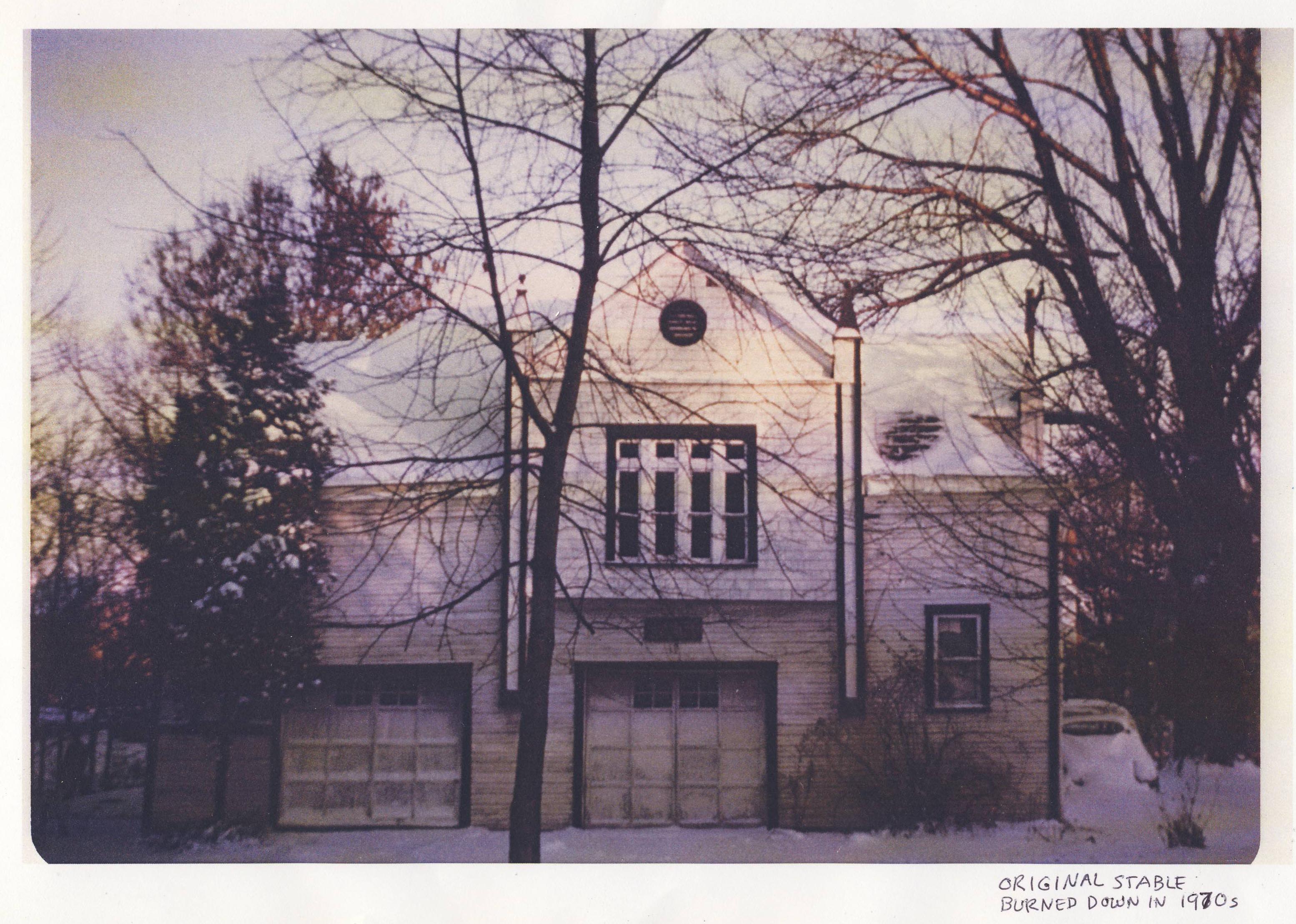
242 East North Broadway used to have a horse stable; it was located behind what is now the garage at that address. The stable stood until the early 1970s, when the then-owner accidentally burned it down.
The story goes that his wife told him not to burn the rubbage so close to the stable! You’ll burn that building down! But her husband did it anyway, and she earned the sad right to say, “I told you so.”
Luckily the current owners have a photograph of that original stable.
[Image courtesy of Gary Means and Jane Hoffelt]West Orchard Lane and North High Street
 A lovely picture of the street at the intersection of West Orchard Lane and North High Street, looking north by northwest, on January 14, 1947. A Sinclair Station was located at the location of the current Donato’s Pizza, and Moore’s Auto Parts was where Momentum Natural Health Store is today. Gray’s Cut Rate Drug Store was next to Moore’s.
Take Me For a Ride In Your Car, Car..
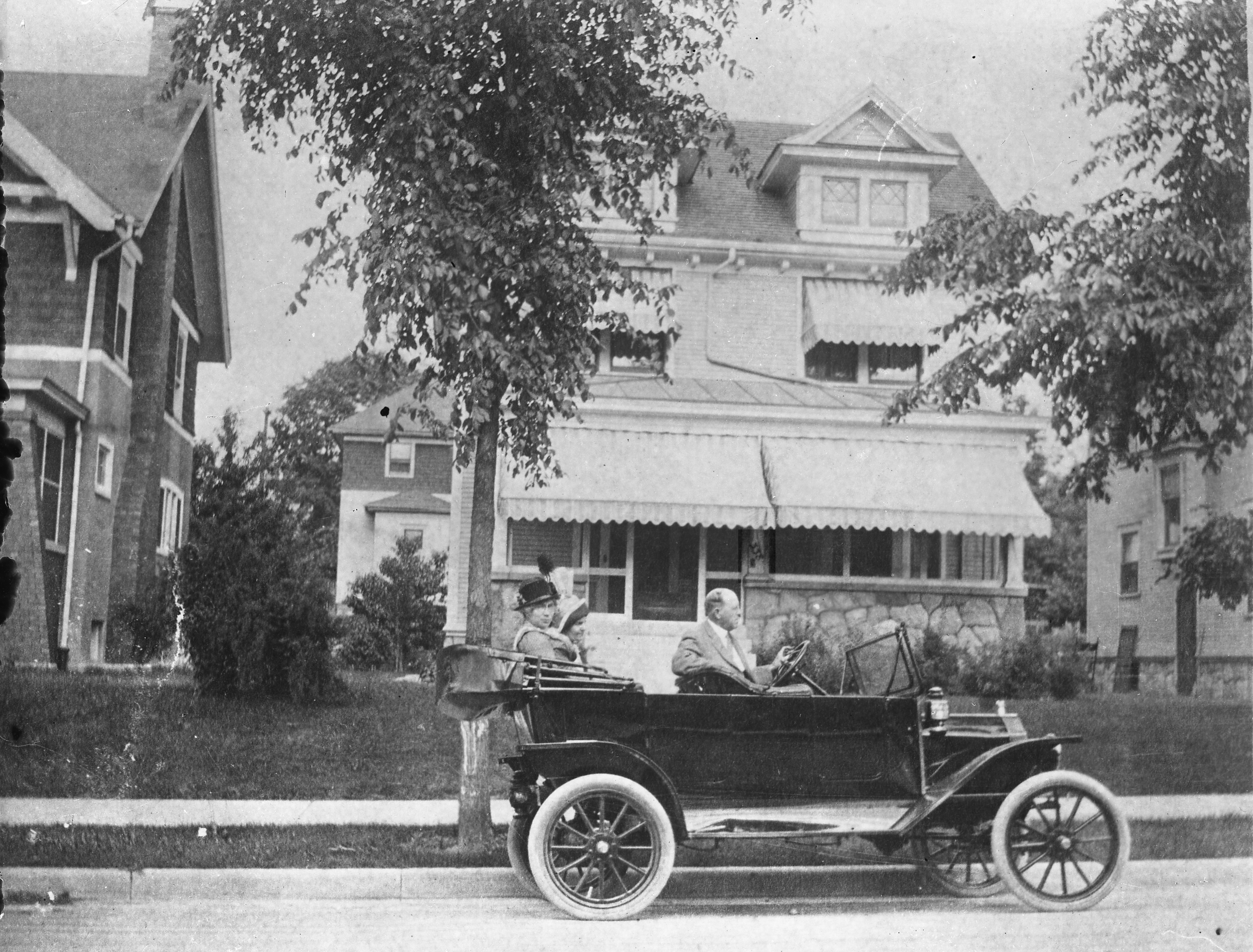 Ron Candage and Rick Lindner kindly identified the car in the photo that I use on my banner. It’s a 1914 Ford touring car.
From Rick:
The 1912 had no front doors (but did have an option to attach removable ones), the 1913 Ford had brass trim on the side lamps, and the 1915 Ford had curved rear fenders. So this pretty much sets the year at 1914.
From Ron:
Ford made 100s of thousands of these in each of these years and they had factories in other countries which produced right hand drive cars. The car in your picture could have been produced at the Ford Motor Company – Columbus Assembly Plant which was located at 427 Cleveland Ave. This factory started in 1914 and closed in 1939. The components arrived here by train and the automobiles were assembled at the plant for delivery to local dealers.
I’d love to also identify the house in the photo, which seems to be at the address “338 [something].” And check out those beautiful columns in the next-door neighbor’s house!
(I’ve rotated the photo since putting it in the banner.)
[Image by C.C. Hollenback, courtesy of the Dawson family.]Indianola’s Rail

In response to John Krygier’s photos of Indianola’s substructure, Alex Campbell sent this lovely photo along.
He says,
There were streetcar tracks on Indianola Avenue from Glen Echo to Oakland Park. The Summit-Steelton standard gauge line was extended north from Glen Echo where the CD&M turned off to head for the private right of way of its Worthington Cutoff. I have conflicting information on just when the Indianola track was built; one date says early 1927 yet it shows up on a 1925 map. It was taken out of service in 1938 when the line was converted to a trolley coach line.
Here is a N. 4th St. photo from 1909 — Fourth Street and 17th Avenue view from southeast corner looking northwest from 17th and west of 4th looking east. Fourth Street north of Chittenden Ave. was the only streetcar line with side of the street right of way in Columbus.
The construction style used to reinforce Indianola (shown in John Krygier’s photos) appear to be similar to tracks used elsewhere in Columbus.
For good measure, Alex also sent along this picture of South 4th St. He says the school building in the left background can still be found on Google maps.

Under Indianola
John Krygier recently sent me the following photos (shown across then down), taken May 2018, with accompanying information:
When the City contractor dug down to put the new median (with trees, plants) on Indianola Ave. by Studio35, I took a few photos of the road subsurface and they can be found here.
The construction of the road was rather interesting. Like many other Clintonville streets, Indianola has brick
pavers under the asphalt.If you look at the photos you will notice that train rails are running perpendicular to the road, and seem to have been used to reinforce the road from below…
I’m wondering if the rails were scrapped from the rail spur that came in from the main line, through Glen Echo (the north side of the ravine) to the old sewer pipe factory (now the site of Columbus International High School).
The cross-section of the roads seems to be (from top down):
Asphalt (newer)
Pavers
Concrete
SoilAlso, here is a PDF about early 20th century street construction in Cleveland, which seems similar to our city streets constructed at the time.
And here is an article about resurfacing roads in Columbus.
Thanks John!
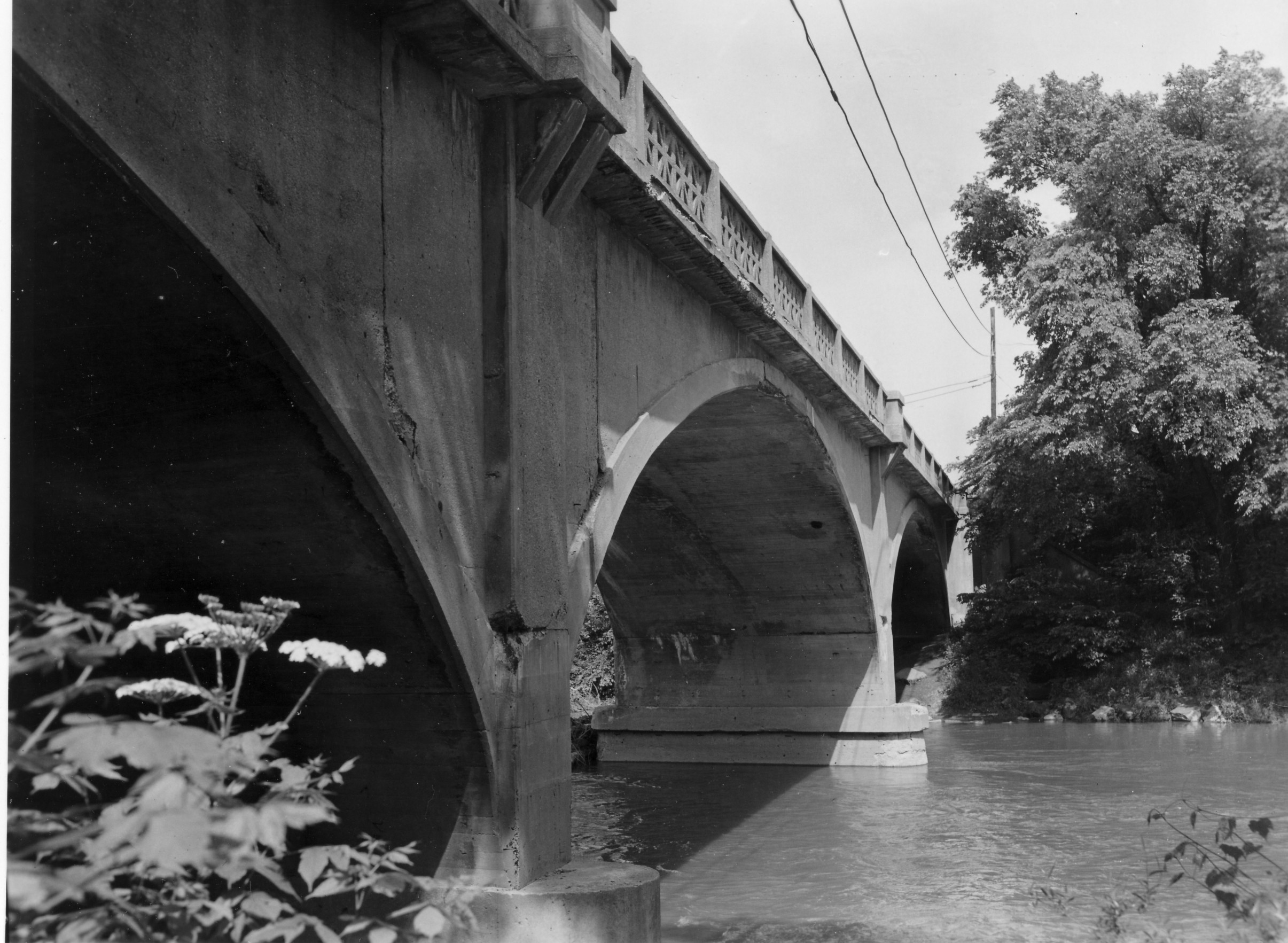
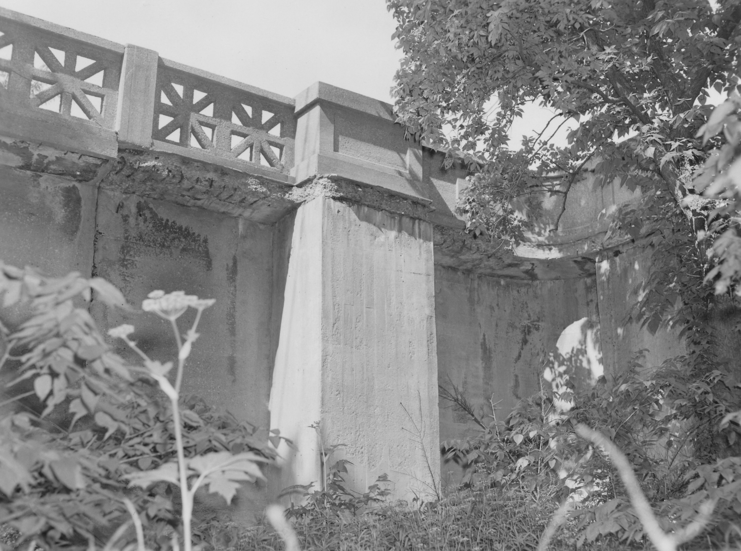
Calumet Street Viaduct
 A nice image of the Calumet Street Viaduct i.e. the Glen Echo / Calumet Street bridge. Elford Company built the bridge around 1924. The photo was taken from the area where the scoreboard on football field of the high school (formerly North High) is located. You can see some houses in the background, which are along Olentangy Street east of Calumet. [Thanks to John Krygier for sending this along to us.]
 And here is the view of those houses today, using September 2016 Google Streetview.
Bower & Co. General Store & Family
Jim Drake recently contributed these wonderful photos and family histories of the Bower (Weber) family.
 Eda Weber Bower and her spouse, Henry G. Bower owned and operated the Bower & Company General Store at 2643 North High St. The photo to the left shows the store’s delivery wagon and, at the right of the image, a section of the Bower family home at 26 East Duncan Street.
 This photo is the 1901 wedding portrait of Eda Weber (1869-1951), of the historic Frederick Weber family, and Henry Bower (1856-1935). They were married on January 1, 1901.
 This photo was taken of the Bowers in 1934. In addition to his civic activities, Henry Bower was a founder and principal stockholder in the Northern Savings Bank (which eventually became part of the Huntington Bank system).
John J. Bower, one of Henry Bower’s brothers, was initially a partner in the general store, but eventually opened a hardware store on the southeast corner of Duncan and High streets. The Bower brothers are shown in this photo (left to right): Ernest E. Bower, Henry G. Bower, Owen Bower (son of Ernest E.), John J. Bower, his son Everett Bower, and Charles Bower.

Although Henry Bower had hoped to have at least one son to inherit the general store, he fathered five daughters instead. After his first daughter, Anna, was born, he pre-selected a male name for each successive child, but in every instance he had to opt for a female form of the name.
Consequently, “Albert Bower” became “Alice Bower,” “George” became “Georgia” Bower, “Henry” became “Henrietta,” and “Wilbur” became “Wilda” Bower.  In this 1960 snapshot, the five daughters are arranged in their birth order from left to right: Anna Bower Mylander, Alice Bower Jesson, Georgia Bower O’Brien, Henrietta Bower Kuntz, and Wilda Bower Drake.
Of the five Bower daughters, Alice (Mrs. Frederick) Jesson had a long and successful career as Director of Restaurants and Cafeterias of the F. & R. Lazarus Company.
(Photos and write-up courtesy of Jim Drake) Note: there is one more image of the Bowers’ cart here.
Sewer pipe factory, and The Mystery of the Pond
 John Krygier found a few maps that he was kind enough to share with us: 3 Sanborn maps of the sewer pipe factory (and later, brick yard) formerly occupying the area where old North High currently sits at 100 Arcadia. Interestingly, the ravine behind the factory was apparently dammed, making a significant (and the only?) pond in Clintonville (not sure if the one in Whetstone counts). John requests that if anyone knows of any other sources documenting this pond, to let him know. You can do that by commenting on this post and I will send it along to John.
John also found a map showing the rail grade that connected the sewer pipe factory to the main RR line to the east. The interurban (Columbus, Marion and Delaware) used part of that spur (north of Glen Echo Park) as a bypass.
This Worthington Bypass went from Indianola Ave, east along the top of Glen Echo, then north up what is now the alley along the RR track, then curved west at North Broadway over to and running parallel along Indianola. This curve is preserved in some of the lots around Oakland Park–in particular, the odd orientation of the IndiaOak Tavern is the result of it being built on a curved parcel, part of the old RR right of way. A map of current parcels (with the approximate route of the RR grade) is also attached.
There are 7 photos of this Worthington bypass around the time it was built, showing the eastern end of C-ville at the time, at this web site.
Thanks, John!


(Photos courtesy of John Krygier)
Train Wreck
 This is a train wreck that occurred in 1880 north of Hudson, at the Big Four Railroad tracks. (Photo courtesy of Judy Cohen)
Dodridge Bridge
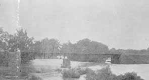 As my book shows, there was once a covered bridge over the Olentangy River at Dodridge Road. The Dodridge covered bridge was replaced by a truss bridge built by the Columbus Bridge Company. This picture shows the replacement bridge in 1890. Fishing from the bridge was a favorite activity for many 20th century Clintonville residents. It was a lovely river, and crappy and small mouth bass abounded. (Photo courtesy of Columbus Metropolitan Libraries)
East North Broadway
According to a 1999 Booster article by Anne Barry, in 1923, East North Broadway was the only paved street north of Fifth Avenue. It was paved with Hallwood Block, and the sidewalks were paved with brick as well. Old maps show a traffic circle at the intersection of East North Broadway and Beech Hill Avenue/Calumet Street, which appears to have been put there for aesthetic reasons. I believe half of this circle remained as late as 1985.
The Jones’ of North Columbus
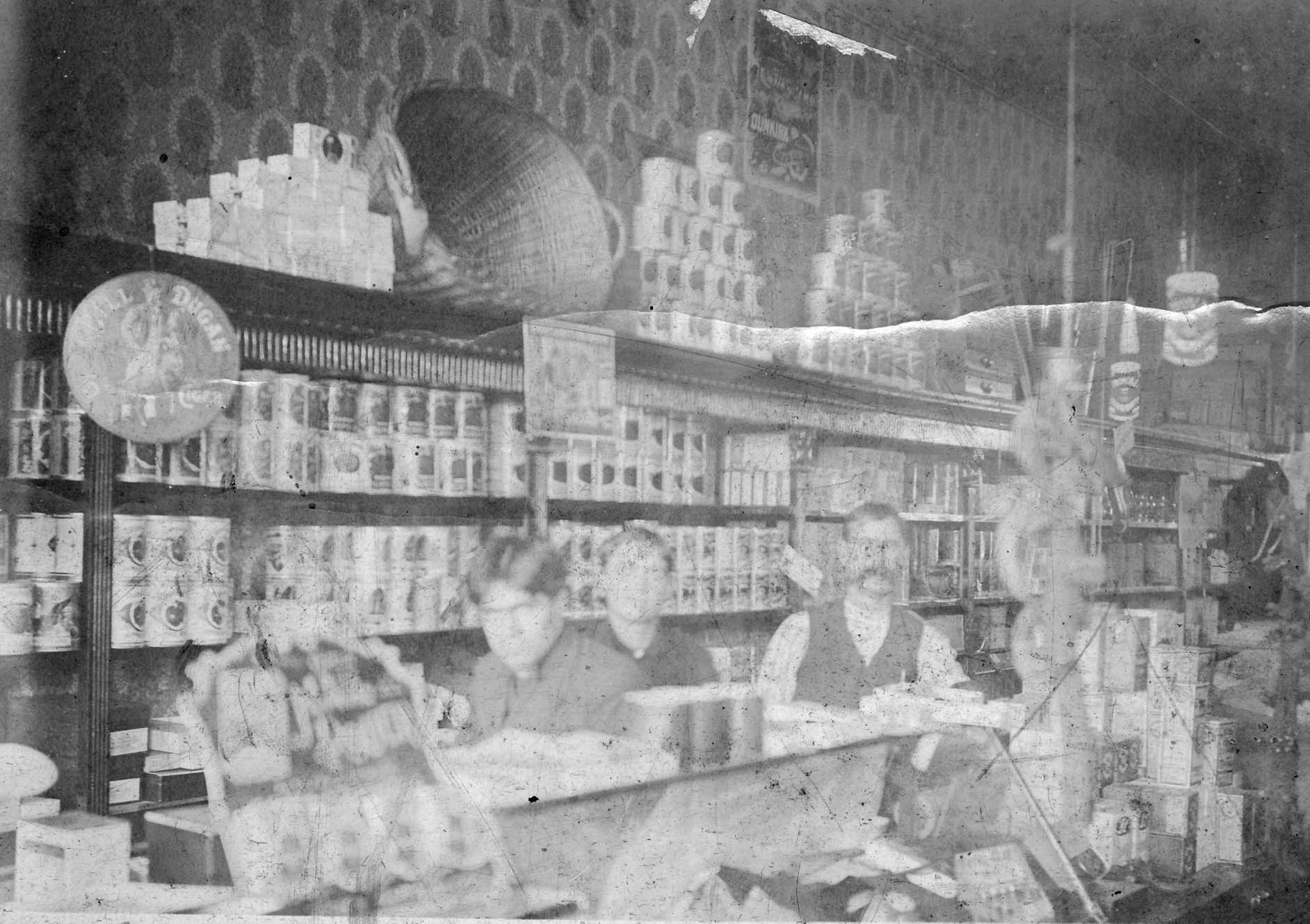 C. F. Jones Grocer used to be located at 2581 North High Street, where Schreiner’s Hardware Store is now. This image was taken around 1904 inside of the Jones Grocery Store. Shown are sons Charles and Clarence with their father Frank Jones.
.
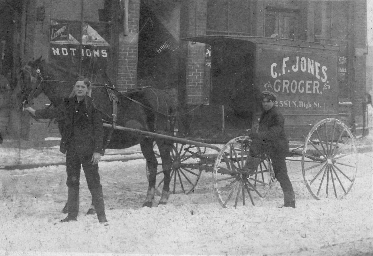 This image of their delivery wagon dates from 1909. Charles Jones is besides the wagon and the young man holding the horse is unknown. They are standing in front of their store.
.
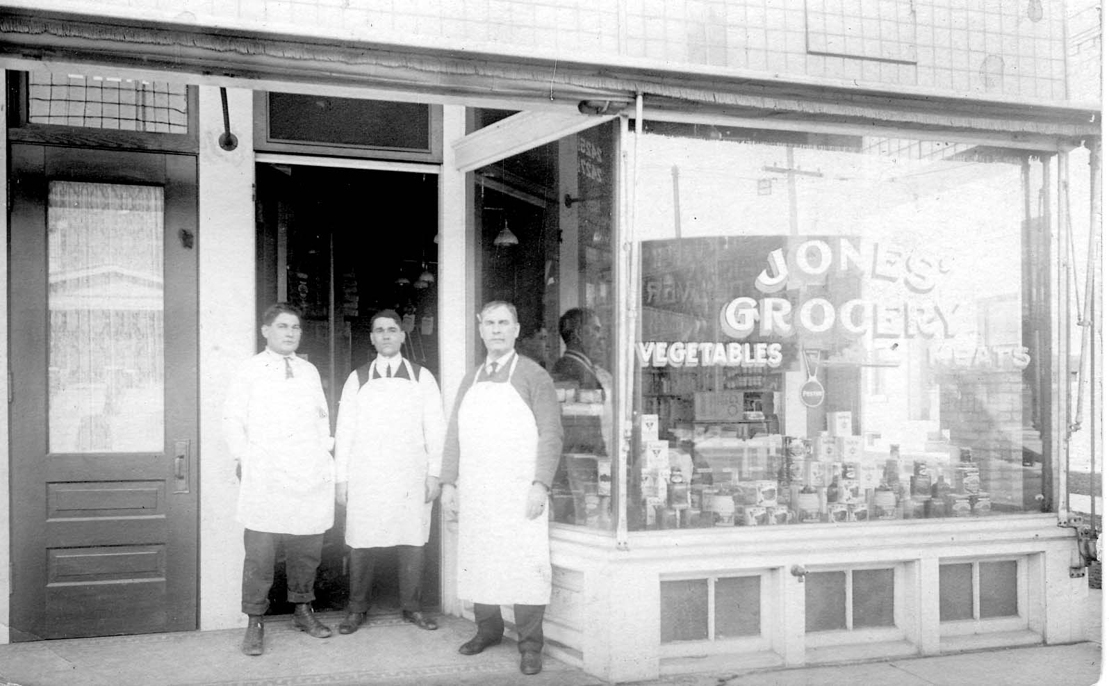 This photo of the C. F. Jones Grocer Co. was taken around 1916. Shown are Charles, Clarence, and their father Frank Jones.
.
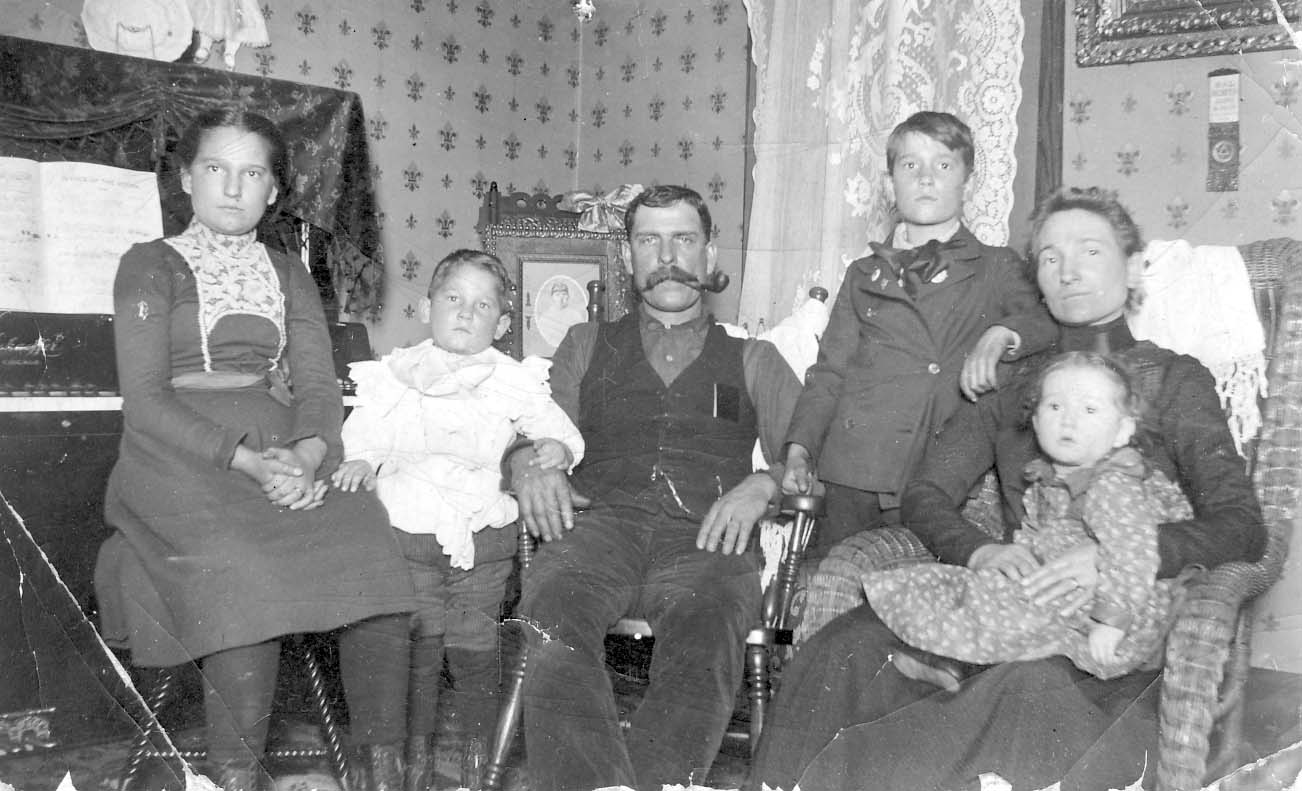 This is a picture of the C. Frank Jones family in their home at 2665 Adams Avenue, Columbus, circa 1900. Bertha May Jones Aurand (1889-1934), Charles M. Jones (1895-1956), C. Frank Jones (1861-1937), Clarence A. Jones (1891-1950), Miriam Tozer Jones (1869-1941), Gladys A. Jones Reiger (1899-1930). (Photos courtesy of Frank Jones.)
Kellar Barns & Livery Stable
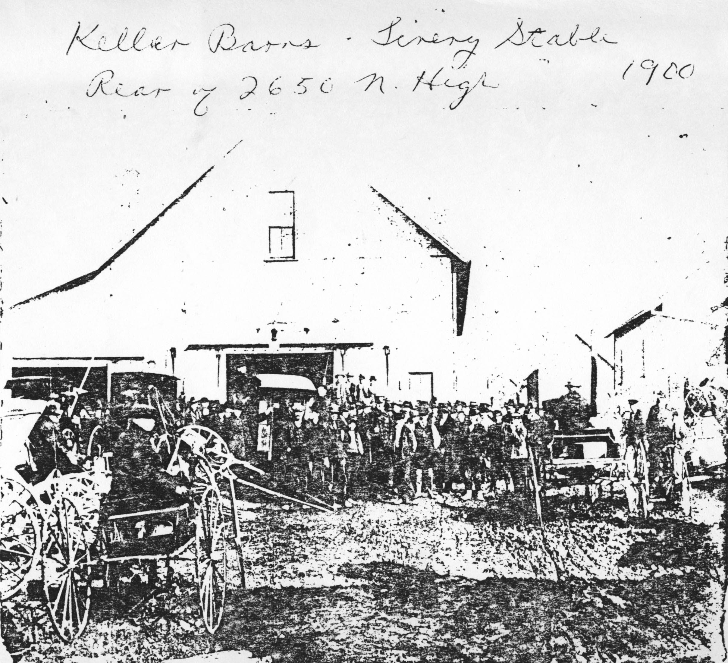 Kellar Barns & Livery Stable, rear of 2650 North High Street, in 1900. (Photocopy courtesy of Frank Jones.)
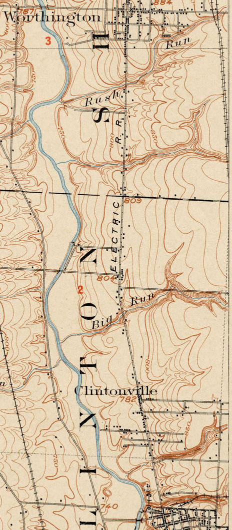
Topographic Map, 1903
This 1903 topographic map shows the road configuration of the intersection of East North Broadway and High Streets. To orient yourself, remember that there were no bridges across the Olentangy River between Dodridge and Henderson, so Dodridge is the southern bridge and Henderson next bridge north of that. Calumet Street did not exist, and many other side streets had as yet to be developed, or were called by different names than they are today.
Toll House
The Worthington Pike, now called High Street, was supported by funds collected from a toll gate which was located opposite from Olentangy Park. The gate was operated by the Applican family, parents of Mrs. N. E. McCoy. The pole was let down each night and not opened until 4:00 a.m. Dr. Albert Cooper was the North Columbus physician at that time. If he had gone north on a call. the toll keeper always waited up for him or else was roused from his sleep in the night to raise the pole and let the doctor pass through on his homeward trip. –from an old undated newspaper clipping
Duncan & High
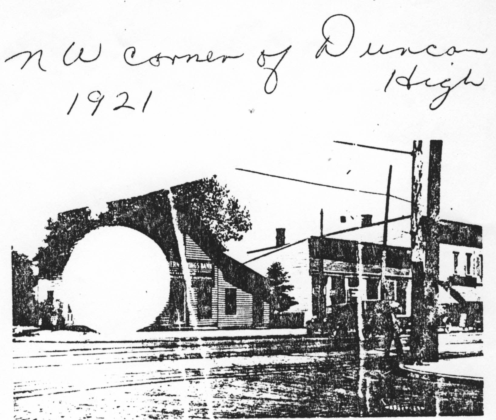 Northwest corner of Duncan and High Street, 1921. (Photocopy courtesy of Frank Jones.)
Clinton Heights Avenue Trivia
 I recently had the benefit of reading an abstract from one of the north-side-of-Clinton-Heights-Avenue residents.
A couple interesting things from the abstract:
Calumet Street, according to the abstract, used to be called “Oak Hill” before the name was changed to “Beech Hill,” and then changed to “Calumet.”
The alley along the north side of Clinton Heights traversed through the school property and then to North Broadway. I have often wondered about this vacated alley, which runs behind the properties along the north side of Clinton Heights Avenue and the south side of East North Broadway. It’s a recessed, ravine-like greenspace that doubtless has many city services running along its banks. You can see this alley in the 1910 and 1920 maps on my web site. The rumor passed to me by former Clinton Heights neighbors was that the North Broadway residents had petitioned the city to vacate this alley, but when the city approved the request, they gave the alley property to the residents of Clinton Heights Avenue instead of splitting it between the residents of the two streets.
The abstract gave me specifics of the vacating. By ordinance No. 38053 duly passed by the Council of the City of Columbus, Ohio, on May 2, 1927, the first alley north of Clinton Heights Avenue “from Beech Hill Avenue to the west line of lot 68,” 12 feet, wide, was vacated. (No indication in City Council minutes of who actually submitted the petition, and I have not bothered to look.) The City Council minutes are attached <here>.
More about the land that became Clinton Heights Avenue…
Henry Cooke once owned part of the property that was later developed into the Clinton Land Company addition.
I have often read an old anecdote that James Chesnut (sometimes spelled “Chestnut”), who owned the house on Wall Street, had blocked the improvement of North High Street along his property near Brighton and North High Street, because a beloved locust tree would be damaged or removed by the paving. The abstract bore some of this out. In the abstract (relevant pages linked here), the property developers were assessed $5400 for improvements in the Worthington and Columbus Plank Road, but, they said, these improvements were never made, because James Chesnut (and others) “were defendants procuring an injunction perpetually enjoining the making of said improvements along his premises.” The Clinton Land Company owners sued, or perhaps countersued, stating that they had been assessed conditional on improvement of North High Street, which improvements had not been made. Who won: You can read the attached excerpts of the abstract and decide for yourself.
Chesnut House

And another amazing old photo of North High Street from Stu Koblentz. This photo also looks north, and was taken just south of the intersection of High and North Broadway. The house on the west (left) behind the little shack (marked “ice”) is the Chesnut house (aka Chestnut house), described in this web site’s “Water for Cookies” entry and also found in my book. The school on the east (right) side of High Street is the old Clinton Township school building, a picture of which is also in my book. You can click on the image to see it in more detail.
Stu’s theory about the Chesnut house is as follows:
The image shows the Chesnut house, facing North High Street, about where it currently stands. The facade that faces Wall Street today is the facade facing High Street. This is verifiable in the chimney placements.
So I went through Joe Testa’s web site and I think I know what happened to the house.
As far as I can tell the house stood approximately at 3327-29 North High Street. In the 1910s, when the house (which appears to have been built in the 1860s or 70s) is pictured, the house had been moved on a pivot to its current location, with its northeast corner remaining close to its original placement. This would account for the front lot build out, the twist in the alley and the sudden reemergence of Wall Street as well as the placement of the house in the picture, and the current location of the house.
What is interesting to me is why did they go to all that trouble, when its fairly common in urban settings to build a street facade onto a house and call it a commercial building. I think that part of the reason is that the house sat further back from High Street, making it too far away to convert to a commercial space commonly found in that era.
Update 2025-08-25 by Shirley–Another possible reason for reorienting this house might be found here.
Pure Oil at Hudson & Indianola
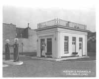 This diminutive Pure Oil gas station was located at the corner of Hudson and Indianola. It had an outdoor lift instead of service bays. The pump globes say Purol and Detonox, indicating the photograph is from the 1920s. Service bays were added to the station later in the decade. Union 76 purchased Pure Oil in 1965, and completely refashioned the station.
Bartlett’s Garage
Tom Bartlett was a leading Clintonville businessman. His garage at Kelso and High existed for many years. (Photo courtesy of the Clintonville Historical Society)


Playing on the railroad
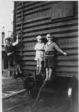 Brevoort brothers Frank Jr., Gordon, and Dale play on a railroad box in or near Worthington, in 1931. (Photo courtesy of Gordon Brevoort)
Standard Oil Station is Outstanding!
 This cute gas station was located at the northern end of the Olentangy Village shopping area in 1939. Today, it is Oldskool restaurant. Is today’s restaurant the same (original) building? I think so. (Photo courtesy of Melissa Goodrich)
Dallas Dupre
Dallas Dupre, whose son still lives in Greater Columbus, was a landscape architect. He had an office located on the west side of North High Street near Weber Road (3073 North High Street), and is reputed to have been the founder of the early roadside park system throughout the U.S. The Dupre family lived in old Beechwold.
North Broadway bridge
These photos, from the Franklin County Engineers Office, show the construction of the North Broadway Bridge in 1939. Construction began on March 16, 1939, but was hampered by flood waters on May 23rd. Two shifts of men were used for a period of four of the 8-1/2 months the bridge was under construction, to bring the project to completion on time. The stone facing of the bridge is natural Columbus limestone in various colors.
Note the temporary bridge in the first couple photographs. (Photos courtesy of Franklin County Engineers)


Please note, this post was revised on 2021-10-17 to provide full-size photos when you click through a photo.
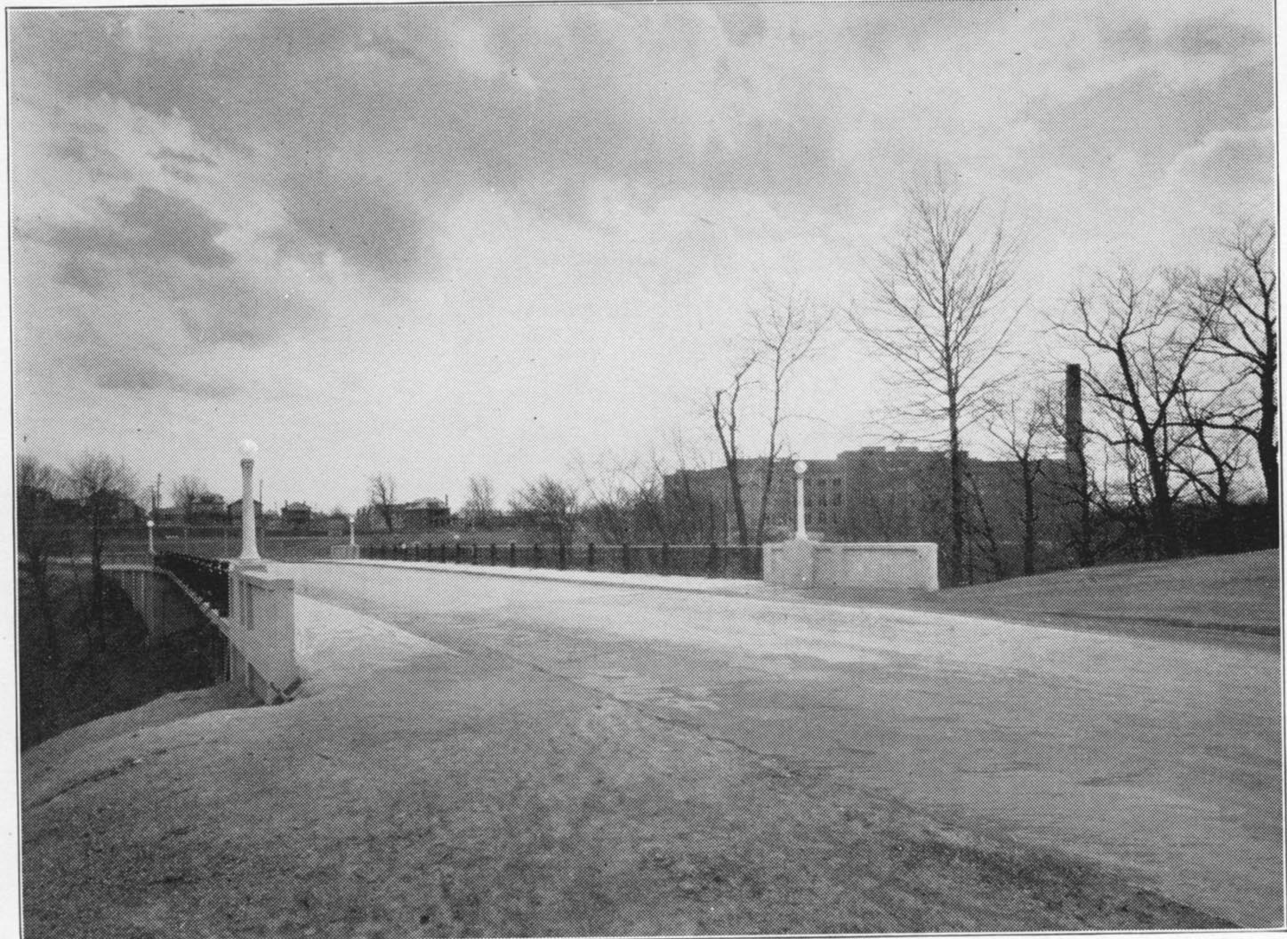
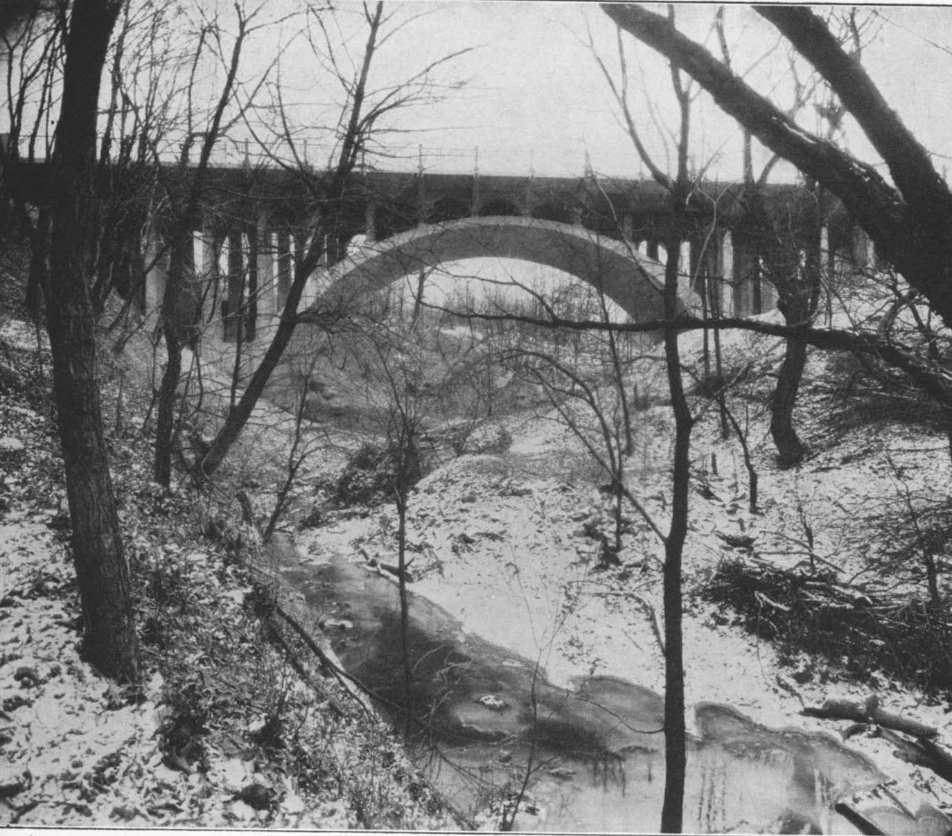
Glen Echo Bridge
Three lovely views of Glen Echo bridge near North High School, were taken in the later 1920s or early 1930s. [From North High Memory books.]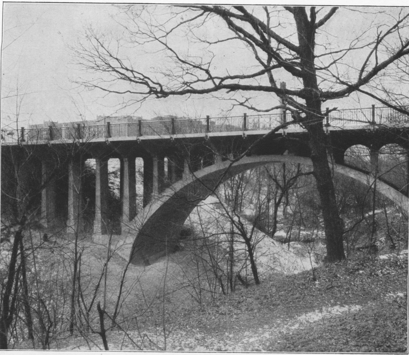
On Top of the World…or at least Arcadia (Street)
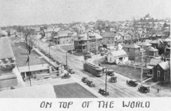 I previously stated that I was unsure where this photos was taken. A reader named James wrote in that it’s “the view from atop the school, facing South East. You can see the edge of the football field along the fence line in the middle left of the pic. The white house in the middle right is still there, at the corner of Adams and Arcadia. That large apt building on the other corner is still there, too.” Thanks, James! The photo was in one of the North High School Memory Books (their yearbook).
[From a North High School Memory Book]
Robert Ohaver (1937-2009)
Robert Ohaver (b. 1920) lived most of his life in Clintonville and on West North Broadway. He had many stories of old Clintonville to share with us. On September 12, 2003, several community members (Ann and Alan Woods, Barbara Hotchkiss, Nancy Kuhel) interviewed him and preserved the conversation on tape. Now you, too, can listen to Mr. Ohaver’s oral history.
Sadly, Bob Ohaver passed away on June 11, 2009. You can find his obituary here. There is another small entry about his aunt on this web site here.
Bob mother was Laura Ohaver and his father was Walter Harvey Ohaver. Bob also had an older brother named Jack Ohaver who lived in Clintonville at 116 E. Dunedin with his wife Clara Ohaver. Clara passed away May 24, 1993, and Jack passed away on June 14, 2000. Jack and Clara had two daughters. Sue Bowman was born May 8, 1940; she passed away January 4, 2000. Sandra Urban born July 30, 1945. [This family information came to me from Jack’s granddaughter and Sandy’s daughter, Lisa Adkins. Thanks, Lisa!]
Each file is about 30 minutes long.
Contents
Track 1.
Brief Ohaver biography; origins of his family moving to West North Broadway; his World War II years; Clinton Theatre; businesses and homes at the interesection of North Broadway and North High Streets; drugstores and candy stores in Clintonville; the house behind 3391 North High Street; Dispatch carrier’s substation; Olentangy Park; the streetcar storage barn at Arcadia.
Track 2.
Olentangy Park cont’d; street fair at North Broadway and High to celebrate Clinton Theatre, the opening of Clinton School pedestrain subway, and the paving of North High Street after a new sewer line had been installed; the Olentangy River; 3 canoe clubs; development of West North Broadway (“the Broadway Extension”) and the Scott farm; development of the area along the adjoining river bank; the Herron [spelling uncertain]/Zinn home at 285 West Kenworth; Bill Moose AKA “Indian Bill”; Chief Leatherlips.
Note: the “Dr. John Scott” is William H. Scott, president of OSU 1883-1895. See my book, page 17, for a photo of his house.
Track 3.
Chief Leatherlips cont’d; house at 273 Erie Road and excavation of nearby gravel pit; the Fuller farm/Whetstone Park; rambling through the woods; Indian Springs golf course; Bill Moose AKA “Indian Bill”; Olentangy Park; North Columbus including the Ramlow Building; Picadilly Theatre; streetcars and interurbans.
Track 4.
Southwick funeral home; Joy Hunt home; Graceland Shopper’s Mart and Patrick Murnan; Clinton Theatre; the Great Depression; Ohaver family; Brighton Road development; Ohaver’s WWII and postwar years.
Track 5.
Ohaver’s return to Columbus from California in 1962; bombing of the Clinton Theatre in the 1930s.
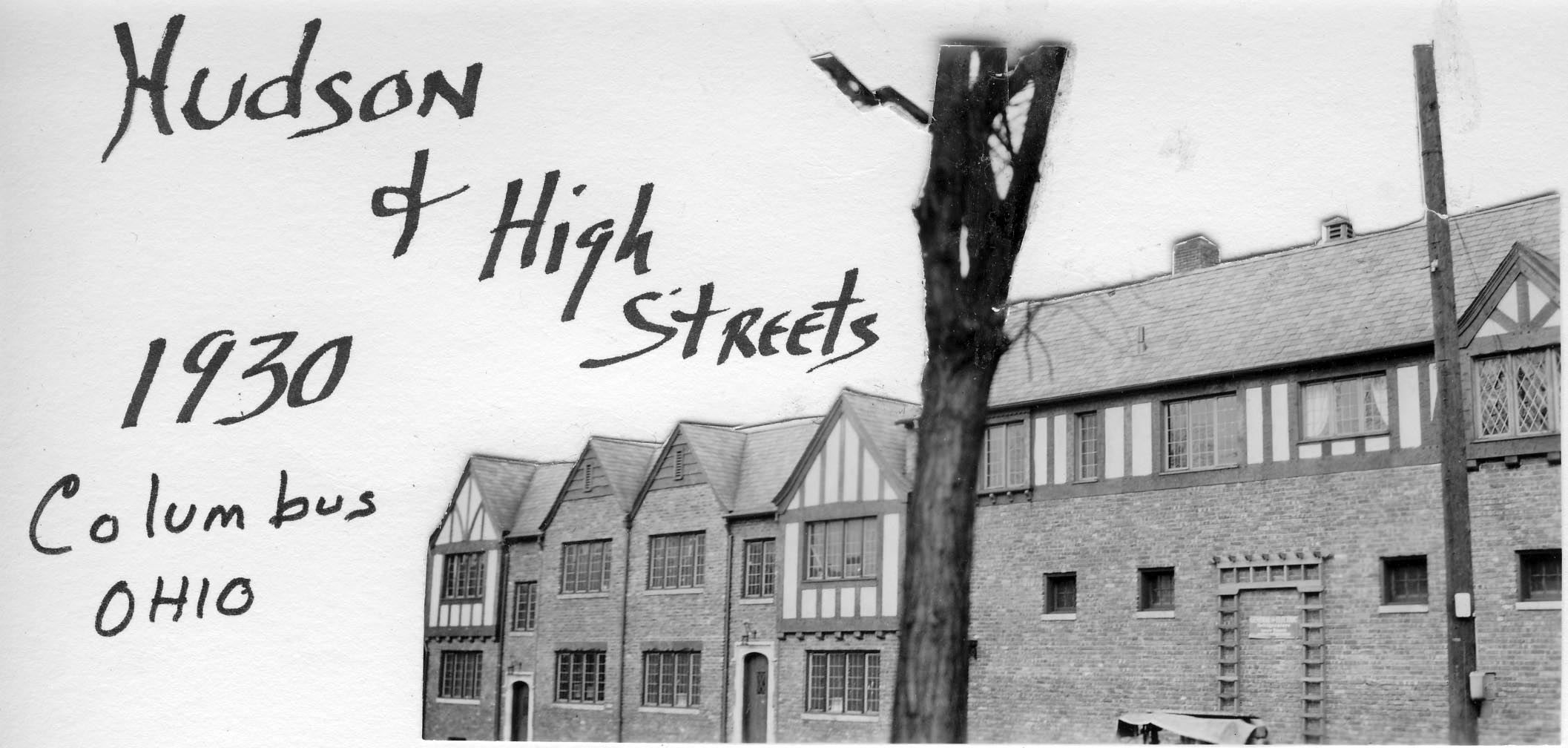
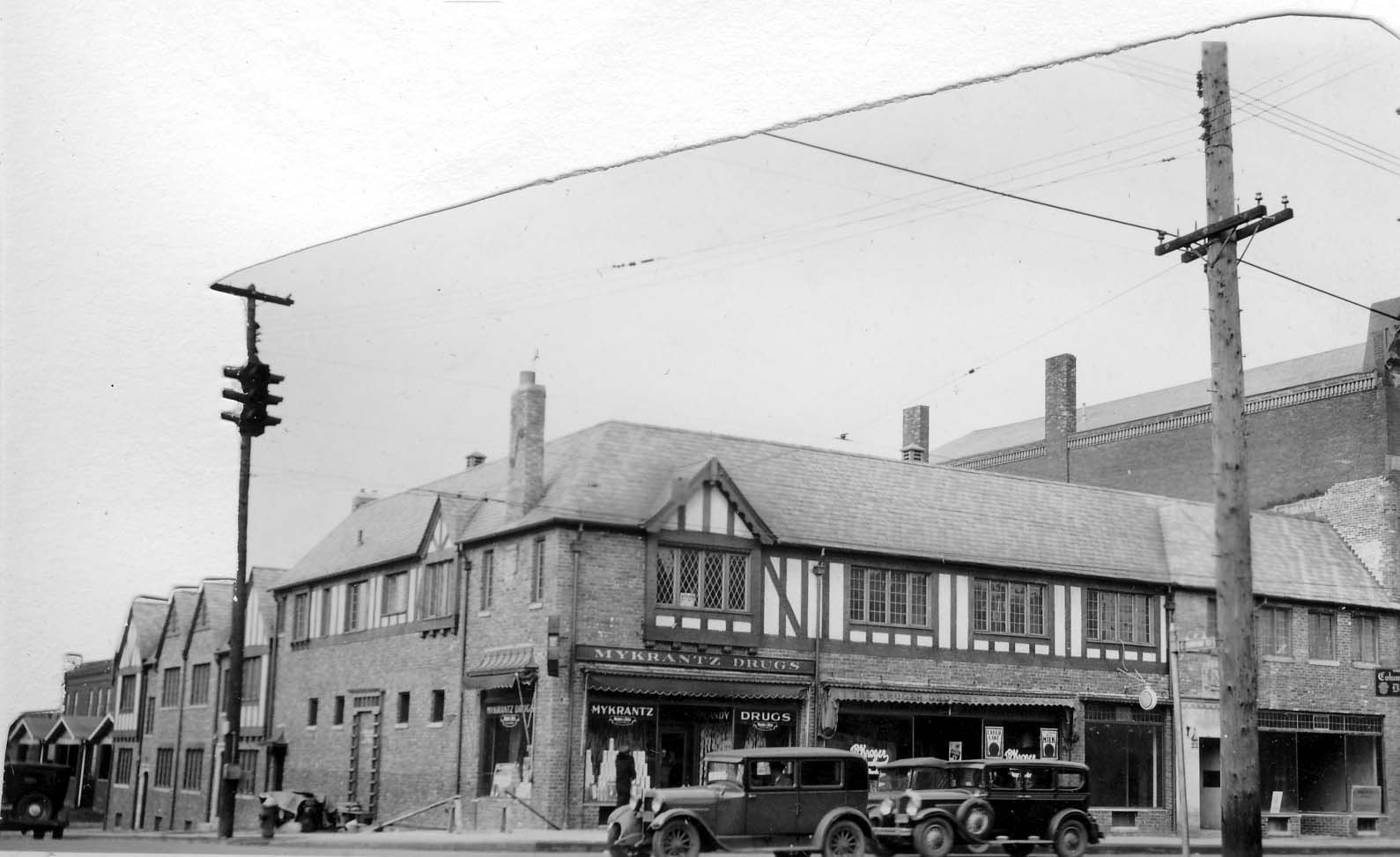
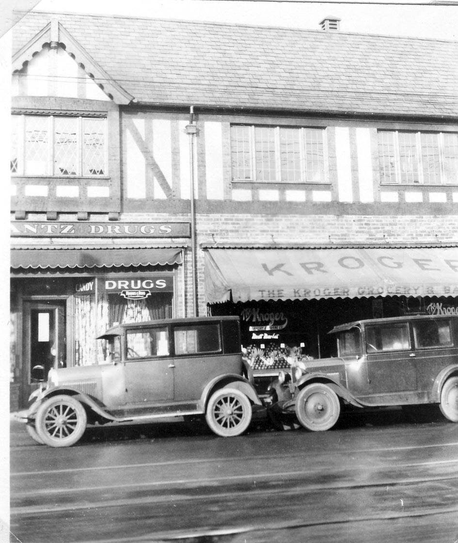
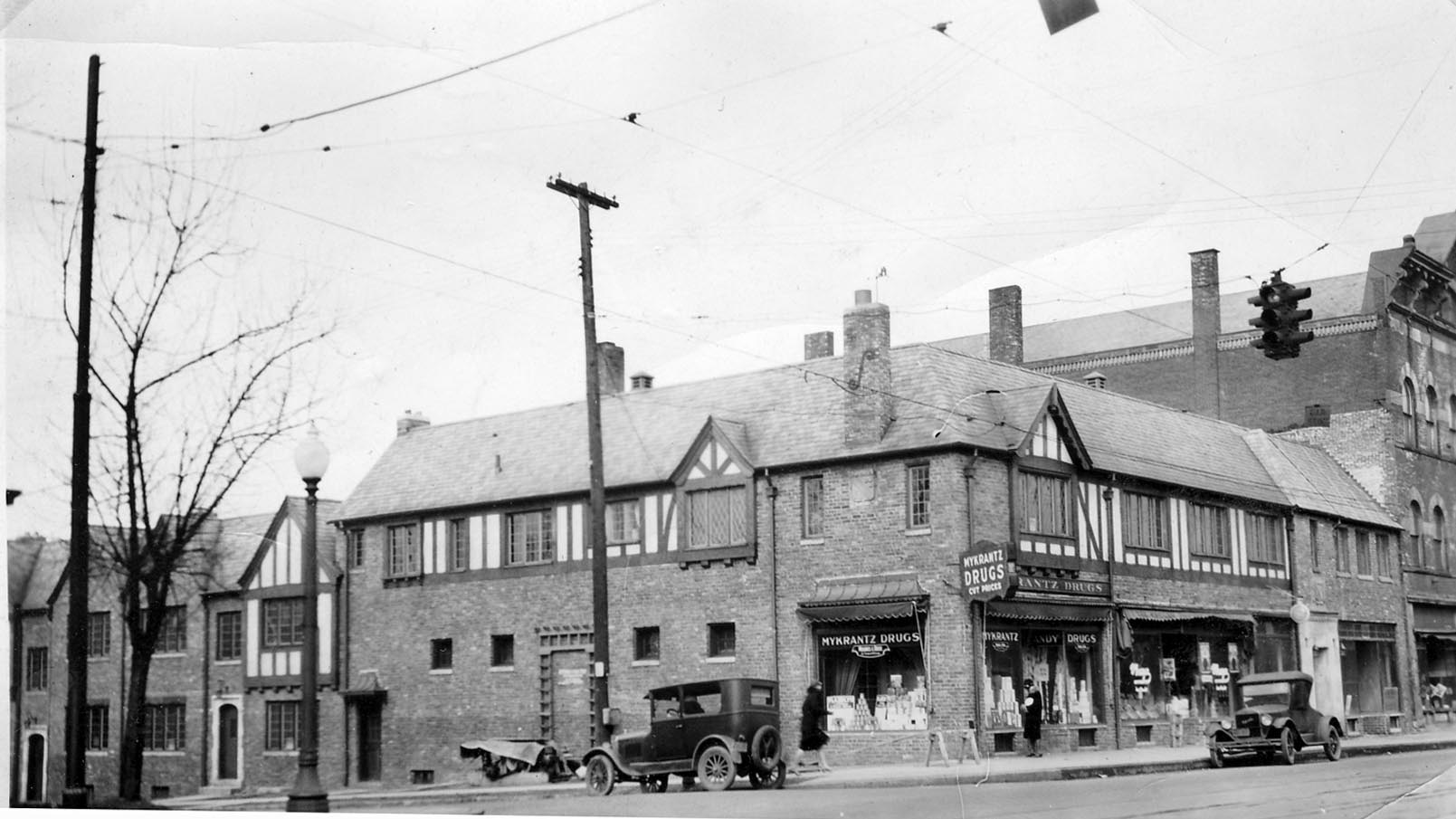
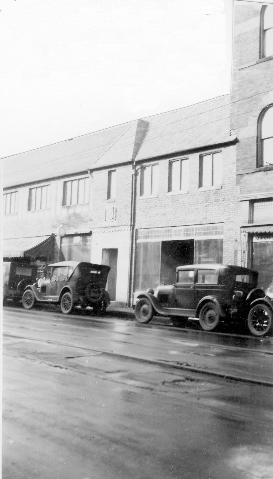
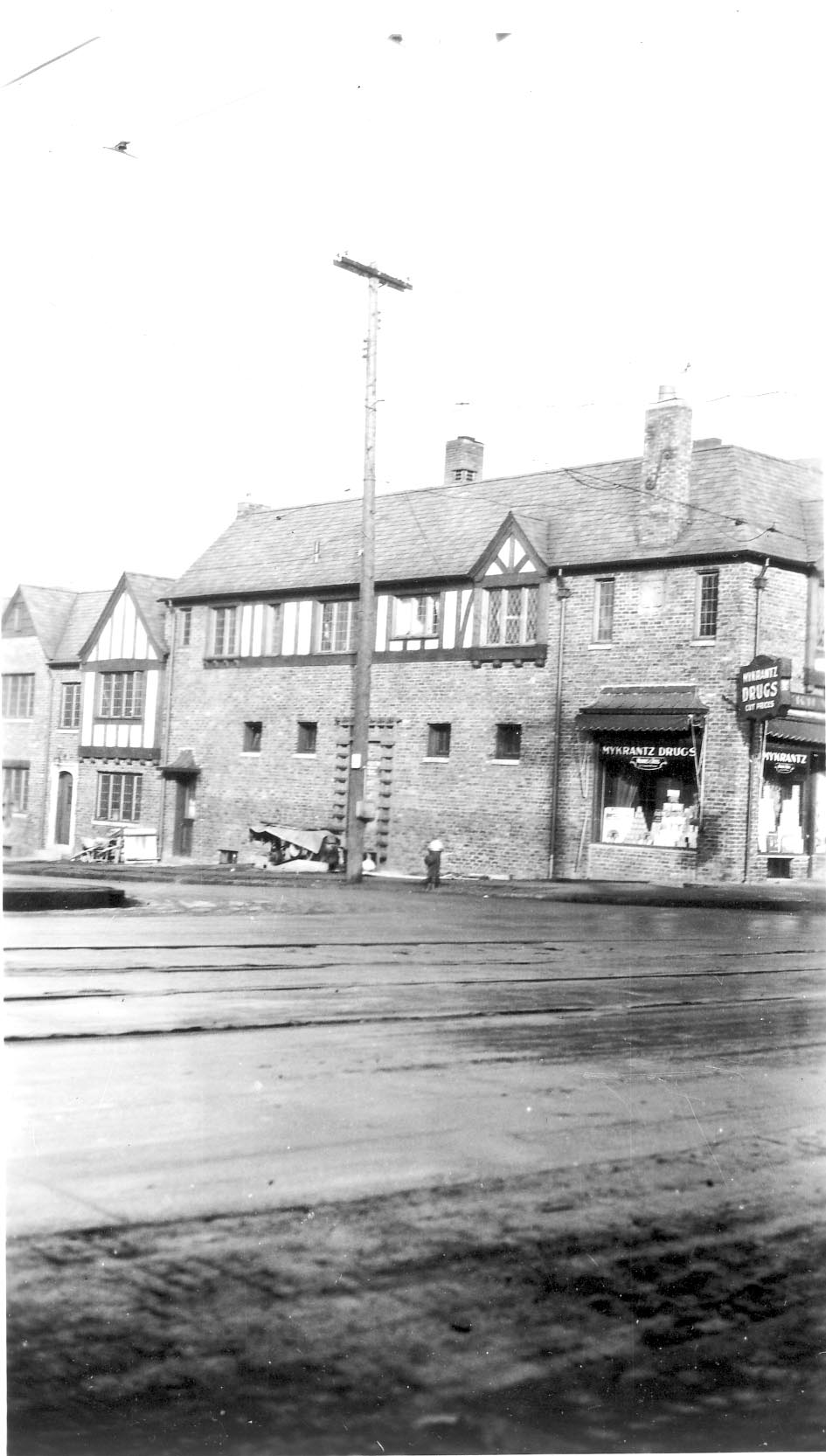
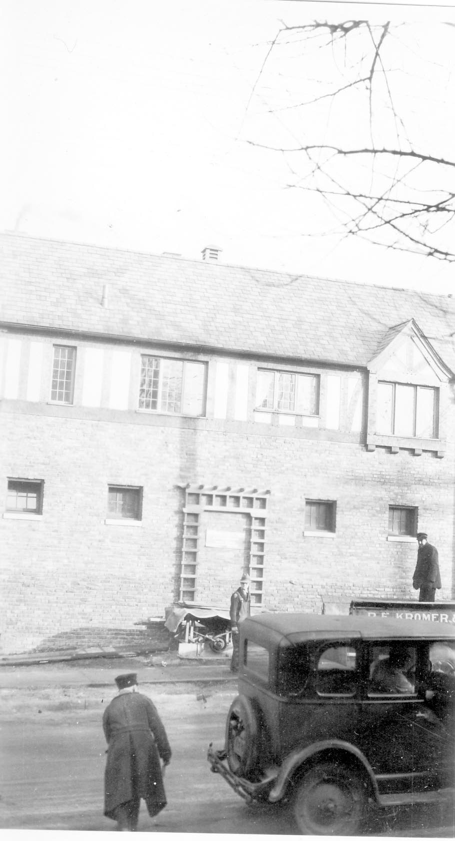
Hudson & High 1930
Some lovely pictures of the northwest corner of Hudson and North High, in 1930. This corner looks about the same today! (Photos courtesy of Frank Jones.)
McDowell’s Garage
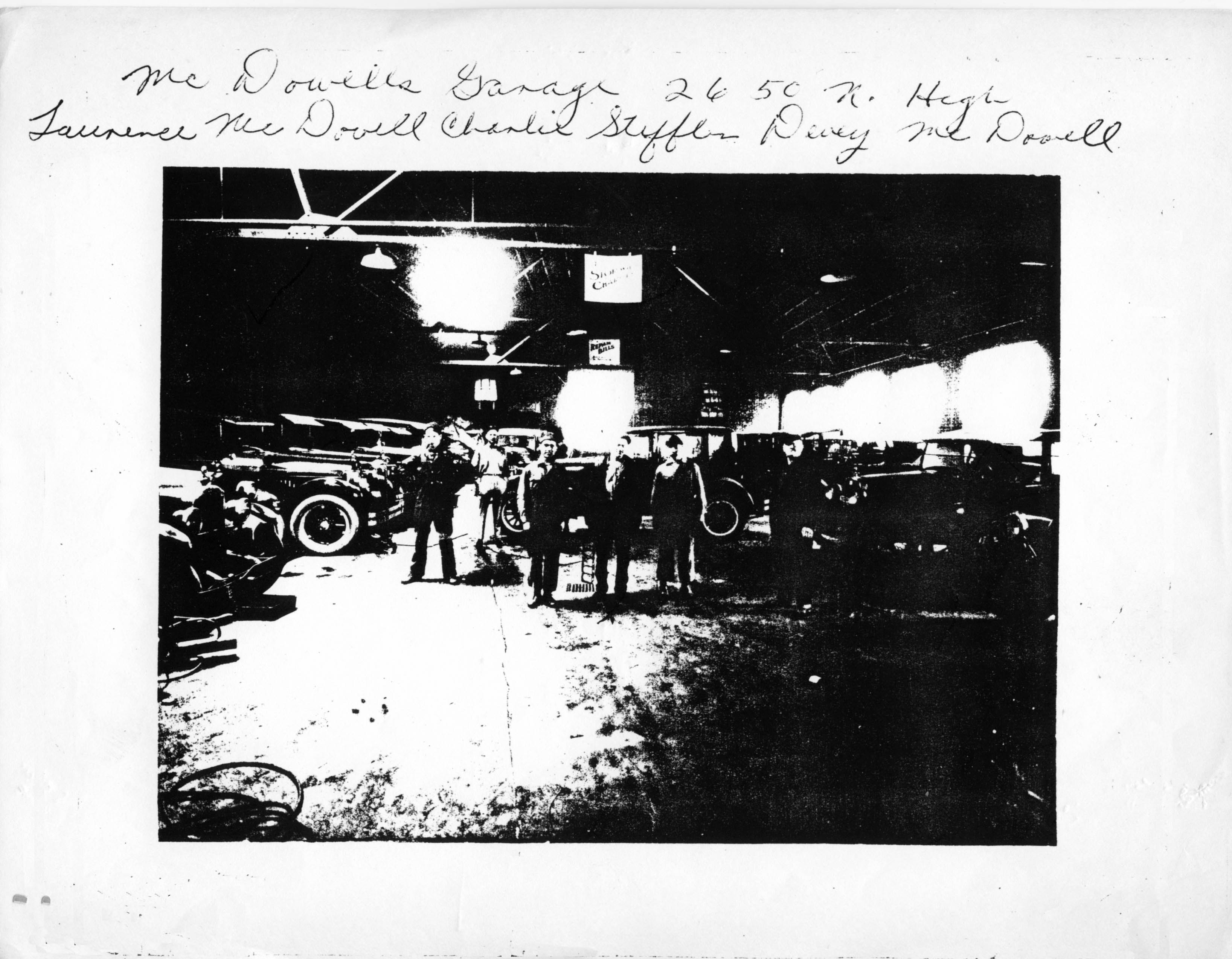 McDowell’s Garage at 2650 North High Street. (Photocopy courtesy of Frank Jones.)
Union Cemetery
 A view of Union Cemetery from Olentangy River Road, in the late 1930s. (Photo courtesy of the Franklin County Engineers)
Street Scene
 This photo was probably taken along Olentangy River Road. Note the smudge pots, which were used before the advent of electrical blinking warning signs. I assume this picture was taken around 1953. (Photo courtesy of Franklin County Engineers)
Henderson Bridge
 The Henderson Bridge was first known as Whip’s Bridge, then Weisheimer Bridge. The present bridge was built circa 1976.
(Photos courtesy of Franklin County Engineers)
Please note: this post was revised on 2021-10-17 to add the 2nd image and to provide larger images when clicking through the thumbnails.
Palmer Miller Nelson Insurance Company
 The Kirkpatrick Insurance Company began in 1855 in Adams County, Ohio, moved to downtown Columbus in 1920, and moved to Clintonville in 1954. They remodeled this brick duplex residence at 3215 High Street. In 1973 they demolished the duplex to the north, and expanded the first building. Eventually the name was changed to reflect ownership by Zeke Palmer, his son Daniel, Steven Miller, and Ronald Nelson. It’s one of the oldest independent insurance agencies in Ohio. (Photo courtesy of Palmer Miller Nelson Insurance Company)
East North Broadway


For the residents of East North Broadway, widening their roadway has been a seemingly endless struggle of defending their property against City Hall. Joyce Schatz–for many years an officer in the East North Broadway Street Association–has kept an archive of the issue, and I’ve linked to it here.
The city claims the right of way is 100 feet. Some research shows that it is 70 feet. Residents’ deeds and surveys are all over the place. Some have 15’ listed, many don’t, including recent purchasers. The majority of the parcels at the end of the street do not have the 15’ easement in their deeds. The deed to Steve and Ann Wilson’s home (one of the three slated to lose their yard), specifically includes the footage and states “…Together with the Fifteen (15) feet off the North Side of East North Broadway vacated by resolution of the County Commissioners of Franklin County, Ohio, on October 7, 1952.”
For those of us who don’t live on East North Broadway, the issue is less “Can the City do it?” but “Should the City do it?’ For the time being, the city is not actively pursuing the widening.