August 29th, 2008
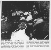
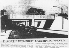
For the residents of East North Broadway, widening their roadway has been a seemingly endless struggle of defending their property against City Hall. Joyce Schatz–for many years an officer in the East North Broadway Street Association–has kept an archive of the issue, and I’ve linked to it here.
The city claims the right of way is 100 feet. Some research shows that it is 70 feet. Residents’ deeds and surveys are all over the place. Some have 15’ listed, many don’t, including recent purchasers. The majority of the parcels at the end of the street do not have the 15’ easement in their deeds. The deed to Steve and Ann Wilson’s home (one of the three slated to lose their yard), specifically includes the footage and states “…Together with the Fifteen (15) feet off the North Side of East North Broadway vacated by resolution of the County Commissioners of Franklin County, Ohio, on October 7, 1952.”
For those of us who don’t live on East North Broadway, the issue is less “Can the City do it?” but “Should the City do it?’ For the time being, the city is not actively pursuing the widening.
Posted in 1900-1940, 1940-present, Houses, Transportation | No Comments »
August 1st, 2008
In my book, Clintonville and Beechwold, I stated that there are 4 ravines in Clintonville. Today there are 4, but originally there were, oh, perhaps 6. The area around Richards and Granden—which used to be called Richards Woods, before it was developed—has been filled in; and there is a low lying ravine between Clinton Heights Avenue and East North Broadway, which was also filled in quite a long time ago.
Posted in Parks & Recreation | No Comments »
August 1st, 2008
I’ve received a few questions about how I went about collecting photographs for my Clintonville and Beechwold book—and why I left some subjects out. Here’s my process. I began by identifying and contacting all the churches and schools in Clintonville. Some churches, like Crestview Presbyterian, had no photographs; others did not, for one reason or another, return my calls. I also hung flyers around town requesting photographs, and spoke with local merchants. I notified The Booster, This Week in Clintonville and several alumni newsletters; both newspapers and several newsletters ran articles about my project. I held open scanning sessions at Clintonville Historical Society meetings and at the Whetstone Branch of the Columbus Metropolitan Library. I researched history and made lots calls to families and businesses that had a hand in creating Clintonville’s history. And so on…
Posted in Background Info | 4 Comments »
August 1st, 2008
These are the Clintonville places that are presently listed on the National Register of Historic Places:
- Berry, Richard Jr., House (Also known as Tomko House)
324 East North Broadway, Columbus
- Coe, Truman and Sylvia Bull, House
75 E. Lakeview Ave., Columbus
- East North Broadway Historic District
Bounded approximately by Broadway Place (a little to the east of North High) on the west to the railroad tracks on the east
- Glen Echo Historic District
Roughly bounded by Glen Echo Ravine, Big Four RR tracks, Indianola Ave., and Hudson St., Columbus
- Graham, A.B., House
159 Clinton Heights Ave., Columbus
- Hamilton, Gilbert H., House
290 Cliffside Dr., Columbus
- North High School (Also known as North Adult Education Center High School)
100 Arcadia Ave., Columbus
- Old Beechwold Historic District
Roughly bounded by W. Jeffrey Pl., N. High, River Park Dr., and Olentangy Blvd.
(I realize Glen Echo neighborhood and the Gilbert Hamilton house are not quite in Clintonville but they are so close, I included them in this list.)
In addition, the following two places are listed on the Columbus Register of Historic Properties:
- Northmoor Engine House
3601 N. High Street, Columbus
- Weisheimer House
286 W. Weisheimer Rd., Columbus
Posted in Background Info | 12 Comments »
August 1st, 2008
At present Clintonville has 3 historical markers that are on the Ohio Historical Markers Program.
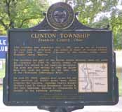
An additional marker in Clintonville was originally sponsored by the Franklin County Historical Society and recently “adopted” by the Clintonville Historical Society. It has recently been refurbished and returned to its original location on the northeast corner of North Broadway and North High Streets. (In 1971 it was moved from the North Broadway location to a spot near the Clintonville Women’s Club to make way for a gas station at North Broadway & High.) The pictures below show the marker before it was refurbished by the Clintonville Historical Society.

There may be other markers in Clintonville and if so I would love to learn about them.
Wouldn’t it be nice to see more of Clintonville’s history told via these markers? For starters, here is a list of possibilities (in no particular order):
- Site of Olentangy Park
- Site of Olentangy Bowling Alley, reputed to be the first automatic pin-setting machine
- Site of Virginia Gay Home
- Site of old Columbus Zoo
- Clinton Chapel at 3100 North High Street
- Cemetery at Clinton Chapel
- Site of first (original) Clintonville Post Office (see marker above)
- Site of Bill Moose encampment and cabin
- Site of Beers Mill
- Site of Weisheimer Mill
- Site of Wyandot Country Club aka Elks Country Club (now the property of the School for the Deaf)
- Site of old Beechwold Theatre
- Studio 35
- Park of Roses
Applications for the Ohio Historical Markers Program flow through the Ohio History Connection. A 2008 Dispatch article stated that markers cost as much as $2150, and that the Ohio Historical Society’s Marker program provides grants of $750 to 20 proposals each year.
The Clintonville Historical Society has recently launched its own campaign to get more markers on the street. They hope to get funding for 3 markers soon:
- Beechwold/Urban Cottages to be placed on High at Dominion,
- Memory Lane/Post office to be place on High at Orchard, and
- SunwallMoonwall Murals/Dominion Land Co. Mound to be placed on Cooke at Indianola.
They plan to select additional markers based on feedback they receive from the community. Their goal is to install 10 markers in 2016. Plans are to obtain that feedback via a display installed at the Whetstone Library in April or May 2016. People interested in funding a marker should contact the Society by phone 614-657-6854 or email mrodger5@columbus.rr.com.
Tags: Recently-revised Post
Posted in Background Info | 1 Comment »
August 1st, 2008
My wish list for photographs (an ongoing list):
- Bliss College
- Bowling Alley at Graceland
- Bowling alley on High Street between Oakland Park and Dunedin
- Broadway Canoe Club
- Capitol Dougnuts
- Clinton League’s tennis courts on Dunedin
- Clintonville Bridge Club
- Clintonville Lumber Company
- Columbus Canoe Club (on Orchard)
- Cyro’s Market
- Ferrill’s at Graceland
- Fleming’s Book Store at Graceland
- Florence Restaurant (advertised in 1927 as being “Clintonville’s Best and Most Popular Eating Place,” at 3274-76 North High)
- Gratziano’s Market
- Hansen’s Bakeries
- Indiaoaka Service Station
- Murry’s, the IGA where Weiland’s Market is today
- Whip’s Vegetable Garden, at 4558 North High Street, at “Mill Road” (Weisheimer Road today)
- Santa arriving at Graceland (on the Friday after Thanksgiving) by helicoptor
Posted in Background Info | 5 Comments »
August 1st, 2008
I had originally planned to include a chapter in my book about notable Clintonville residents. Oddly, I was unable to acquire a balanced set of information about Clintonville’s notables. But here are the names of some of those who were nominated, either renowned for their contribution to Clintonville or because they were renown in their chosen field:
- Armbruster, Mathias (lived at 3100 North High Street where Southwick-Good & Fortkamp Funeral Chapel now stands)
- Barker, Skip, d. 2008
- Breunig, Sarah—civic leader (Glenmont Ave.)
- Dawson, Harold
- Dodge, Mel (201 Girard Ave)
- Dupre, Dallas–landscape architect (whose office was at 3073 North High) who is credited with founding the nation’s system of roadside parks
- Gessaman, Myron–Columbus mayor (he lived at 4206 Fairoaks Avenue and also at 147 Rustic Bridge Road)
- Gillie, William and Catherine
- Gowdy, Harry “Hank” (address listed as 384 Fallis Road)
- Graham, A.B.–founder of 4-H Clubs (lived at 159 Clinton Heights Avenue)
- Herbert, Paul M. (307 Olentangy Blvd.)
- Hollenback, Rand & his son Donal
- Hutchins, Edward F., 1925-2005, Dispatch writer, park director from 1971 – 1990s (5301 North High Street Apt. C)
- Jeffrey, Joseph A.
- Koblentz, Morris
- Koch, Freda Postle–journalist, writer and civic leader (Oakland Park Avenue)
- Marshall, George Sidney, 1869-1956–Columbus mayor
- Martin, James Boyd—architect (East North Broadway)
- Moose, Bill–last of the area’s local Wyandot Indians
- Morrill, Paul–artist
- Murnan, Patrick–owned a horse farm where Graceland Shopping Center now stands
- Nicodemus, Chester–artist (Clinton Heights Avenue)
- Reinhardt, Dana–Columbus mayor
- Rhodes, Jim–Ohio Governor
- Rogers, Carl–psychologist (lived at 4857 Rustic Bridge while a professor at OSU)
- Scott, William H.– president of OSU
- Sensenbrenner, Jack, 1902 – 1991–Columbus mayor
- Shannon, Fred–photographer
- Thomas, Edward Sinclair–naturalist
- Tyack, George E. (69 Croswell Road, in 1960)
There are of course many others and I welcome input on this list
Tags: Background Info
Posted in People | No Comments »
August 1st, 2008
Historic Inventories are brief “snapshot” assessments of buildings to determine whether the buildings are of historic interest. Just 1 or 2 pages in length, an inventory is intended to provide a brief description of the location, background, and architecture of a building, site, structure, or object of architectural or historical significance.
The inventories have been written by students or by dedicated residents such as those in the Old Beechwold area, under the auspices of the Ohio Historical Society Historic Preservation Office. (The Beechwold residents did an especially terrific job of inventorying their neighborhood.) For more information about Ohio Historic Inventory Program, click here.
I’ve made a map of the places in Clintonville that have been inventoried; click on the thumbnail to the right to see it.
Linked below, in PDF format, are the historic-inventories for buildings in Clintonville as of July 2008.
Old Beechwold:
Old Beechwold Historic District Nomination
4765 North High, aka “the Gatekeeper’s House,” and also this version
4475 North High
44 West Jeffrey Place
177 West Jeffrey Place
30 West Beechwold
62 West Beechwold
80 West Beechwold
100 West Beechwold, and also this version
150 West Beechwold
209 West Beechwold
4783 Olentangy Blvd
4793 Olentangy Blvd
4805 Olentangy Blvd
4817 Olentangy Blvd and also this version
4820 Olentangy Blvd
4827 Olentangy Blvd
4831 Olentangy Blvd
4837 Olentangy Blvd
4935 Olentangy Blvd
23 West Riverview Park
75 West Riverview Park
81 West Riverview Park
121 Riverview Park
197 Riverview Park
157 Rustic Bridge
222 Rustic Bridge
4787 Rustic Bridge
4795 Rustic Bridge
4857 Rustic Bridge
4866 Rustic Bridge
4876 Rustic Bridge
4 West Royal Forest
52 West Royal Forest
91 West Royal Forest
115 West Royal Forest
128 West Royal Forest
201 West Royal Forest
North Broadway:
65 East North Broadway
77 East North Broadway
150 East North Broadway
155 East North Broadway
162 East North Broadway
177 East North Broadway
456 East North Broadway
489 East North Broadway
Elsewhere in Clintonville:
3119 North High
3377-3381 North High (Clinton Theatre)
3783 North High
3535 North High
149 East Kelso
45 East Crestview
238 Crestview
129-131 West Weber
259 Walhalla
334 Walhalla
224 East California
91 West Longview
191 West Delphi
314 West Kanawha
163 Kenworth
203 Kenworth
265 Kenworth
285 Kenworth
289 Kenworth
629a Oakland Park
645 Oakland Park
189 Northmoor
3624 Weston Place
214 Arden (a Lustron home)
100 Webster Park
213 Webster Park
7 West Henderson (Maple Grove Church)
45 Weisheimer
239 Weisheimer
286 Weisheimer
And (technically) just south of Clintonville:
100 Arcadia (Old North High School)
Glen Echo United Presbyterian Church
290 Cliffside Dr
17 West Dodridge
44 West Dodridge and 44 West Dodridge
96-98 East Dodridge
Posted in Background Info, Businesses, Houses | No Comments »
August 1st, 2008
 In addition to compiling a list of Clintonville’s “notable people,” I have often wanted to see a list of Clintonville art and artists. My list might include:
Jodi Kushins, artist of Smith’s Deli external mural
Smith’s Deli’s indoor murals as well
Chad Bender (children books)
Jerry Devine (chain saw art, out of Como Mower Service & Sales on Indianola)
Harlow Ballard (digital art)
Tim George (Etch-a-Sketch artist)
Chester Nicodemus (ceramics)
Mac O. Shaffer (photographer)
Fred Shannon (photographer)
Mathias Armbruster
Art in Clintonville churches
Marlo Bartels’ Skyline mural formerly at Clinton Elementary School
Please add to my list in the Comments below!
Posted in 1900-1940, 1940-present, Background Info, People | 1 Comment »
August 1st, 2008
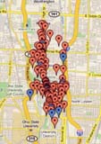 Several people mentioned to me that they’d used my Clintonville and Beechwold book as a driving tour of Clintonville. To make it more convenient to do so, here’s a Google map of all the locations in my book.
Posted in Background Info | No Comments »


 In addition to compiling a list of Clintonville’s “
