Rathbone Cemetery and Clinton Chapel Cemetery
 Joe Smith has an intriguing theory about Clintonville’s elusive Rathbone Cemetery. I think it’s interesting; what do you think?
From Joe:
I came across some maps that the Works Progress Administration (WPA) did from 1935-1943, as part of FDR’s “New Deal” programs. One Clinton Township map particularly caught my eye. It was named (by them) the “John Rathbone Cemetery.” There’s is a link to that particular map on an Ohio History Connection affiliated website (link here). To date, I have only found two other websites that make reference to that cemetery by name:
dev.clintonvillehistory.org/ website;
FCGHS website.I have spent the past few days trying to locate this cemetery. It has been confusing, because the WPA listed it at the corner of US-23 and C-93. As you know, today US-23 follows Indianola Avenue starting at Hudson Street. But I believe prior to the 1960s it was actually still North High Street. C-93 is Hudson Street, according to the Franklin County Engineers (link to PDF here). So, using the WPA location (0.9 miles north of Hudson, and 150 feet east of High), we are at Clinton Chapel Cemetery!
I was very impressed by the WPA map drawings, well before computer aided design (CAD) and printers/plotters were available. So, I took their map and made a rough estimate of the dimensions of the “John Rathbone Cemetery,” and it also fits (within an acceptable tolerance) the known dimensions of Clinton Chapel Cemetery! Three of the boundaries are within 5% but the east boundary is off nearly 10%. I think that is due to inaccuracies with the measuring and/or digitization of their maps.
I know everyone likes maps, so I’ve attached the one I created (see above) to support my findings that Clinton Chapel now has at least three alternate names:
North M.E. Cemetery
Armbruster Cemetery
John Rathbone Cemetery
More from Joe:
There were six Clinton Township cemeteries that WPA reported on: Amaranth Abbey Mausoleum, John Rathbone Cemetery, Kempton Cemetery, Mc. Kendree M. E. Church Cemetery, Union Cemetery, and Webster Cemetery. Note, Cooke and Clinton Chapel Cemeteries were not on their list.
Here’s a link to the very cool 1920 Baist Map earlier (it’s here.)
Other general observations:
Both Rathbone and Clinton Chapel cemeteries were of similar orientation, size and shape (0.47 acres vs 0.50 acres). The Clinton acreage is also an estimate. I actually expected Rathbone acreage to be higher, given that each of the borders are slightly larger, but again I think this is more due to issues with precision.
Here is a comparison of the border dimensions (in feet) for each cemetery. The borders for Rathbone were estimated based on pixel counts on the WPA map.
Border Clinton Rathbone North 200.00′ 200.00′ South’ 196.00′ 200.06′ East 97.02′ 107.06′ West 124.00′ 128.30′
What do you think? Talk about an “identity crisis!” Feel free to comment below.
To be sure, there remain some “unknowns”, such as the fact that Ohio Genealogical Society lists both a Rathbone Cemetery in Sharon Township and a John Rathbone Cemetery in Clinton Township. There may have been a family burial plot for the Rathbone/Wetmore family, graves in which were moved to Greenlawn at an unknown past date. I have no facts to back that up! I’m just leaving this possibility on the table until we can find out more. As Joe states, I mention a Rathbone Cemetery in prior posts. I learned about that from Algy McBride, past president of the Clintonville Historical Society and also of the Franklin County Genealogical Society. Algy passed away in 2015 and is greatly missed.
[This entire entry is courtesy of Joe Smith. Thanks Joe!]Good News, Bad News
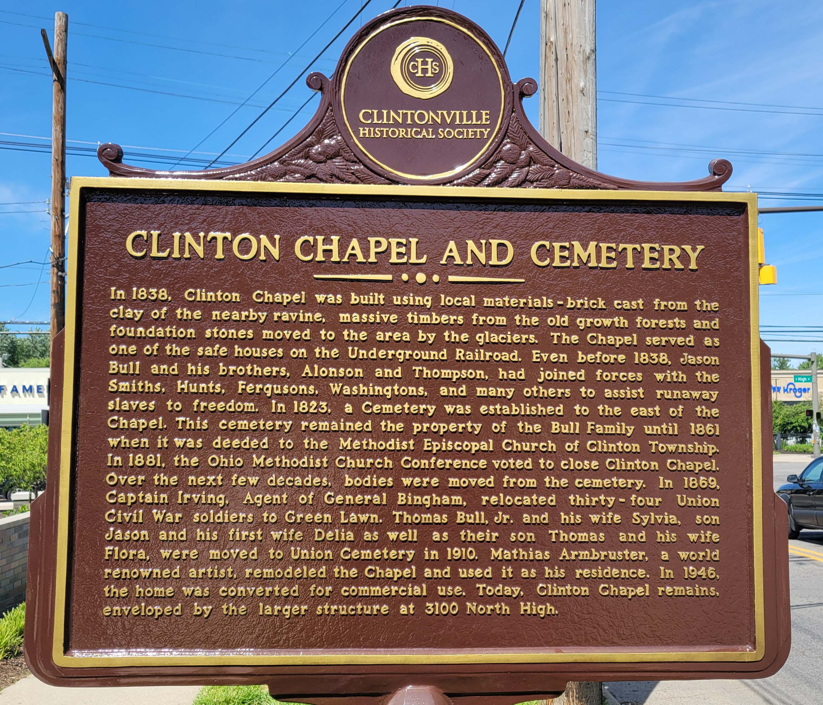
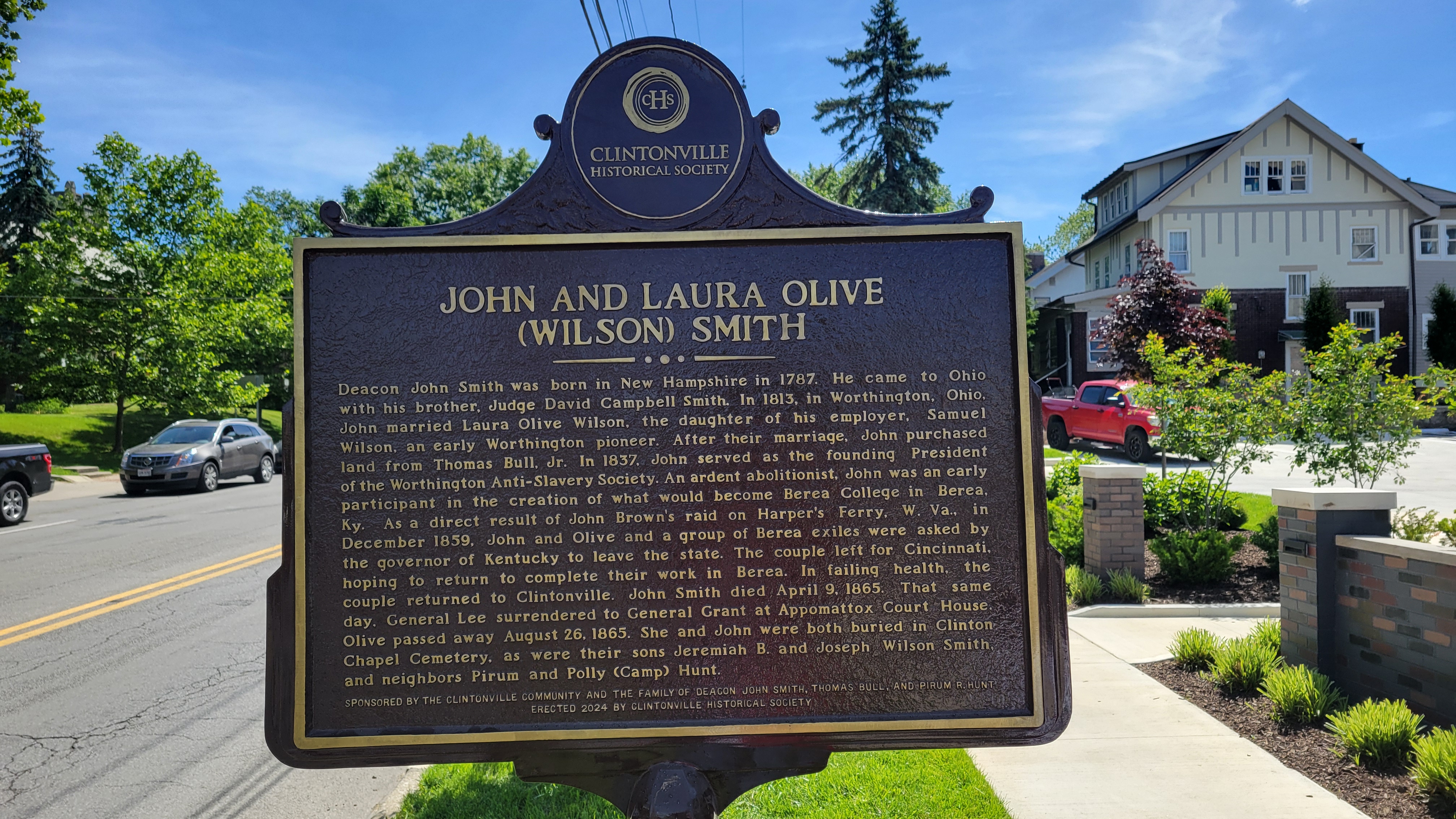
On the bright side: Clintonville Historical Society has erected a new plaque for the Clinton Chapel and for John and Laura Olive (Wilson) Smith near the corner of East North Broadway and North High. It gives us pause to remember slaves and slavery in the Unites States and to give thanks to the people who fought against it.
On the bad news side: it’s very unfortunate, from my perspective, that 12 staff were recently laid off from Ohio’s Historic Preservation Office. The federal government mandates that every state must have this sort of office, and to accompany that mandate they give the offices some money to fulfill their mission. That money was apparently withdrawn by DOGE and so Ohio History Connection had to terminate staff. Here’s a link to a newspaper article about the staff terminations.
[Photos courtesy of Joe Smith.]Lust You Be Tempted…
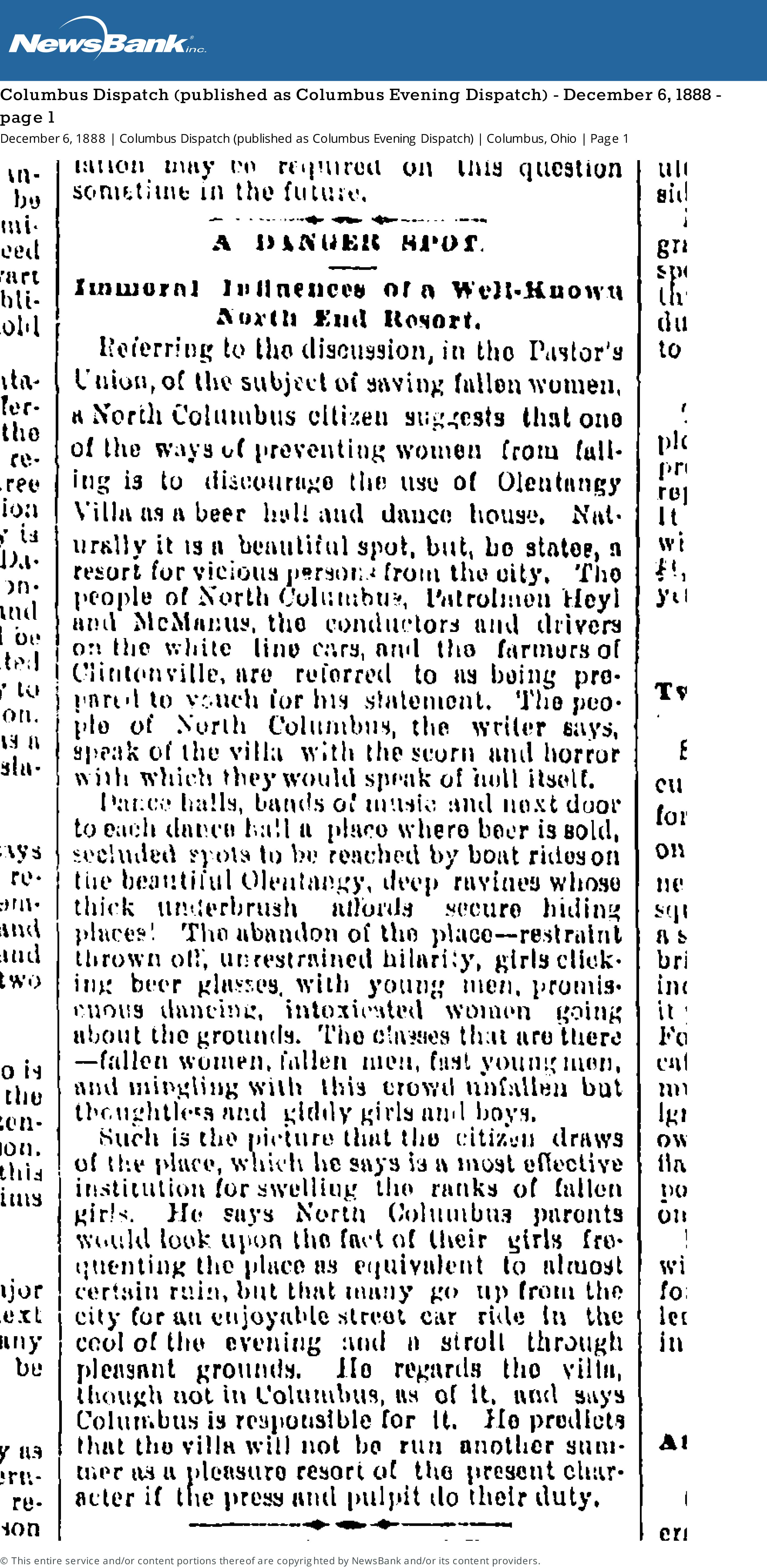
[From the Columbus Dispatch (published as Columbus Evening Dispatch) Thursday December 6, 1888 page 1]A danger Spot
Immoral Influences of a Well-Known North End Resort
Referring to the discussion, in the Pastor’s Union, of the subject of saving women, a North Columbus citizen suggests that one of the ways of preventing women from falling is to discourage the use of Olentangy Villa as a beer hall and dance house. Naturally it is a beautiful spot, but, he states, a resort for vicious persons from the city. The people of North Columbus, Patrolman Heyl and McManus, the conductors and drivers on the white line cars, and the farmers of Clintonville are referred to as being prepared to vouch for his statement. The people of North Columbus, the writer says, speak of the villa with scorn and horror with which they would speak of hell itself.Dance halls, bands of music and next door to each dance hall a place where beer is sold, secluded spots to be reached by boat rides on the beautiful Olentangy, deep ravines whose thick underbrush affords secure hiding places! The abandon of the place–restraint thrown off, unrestrained hilarity, girls clicking beer glasses, with young men, promiscuous dancing, intoxicated women going about the grounds. The classes that are there–fallen women, fallen men, fast young men, and mingling with this crowd unfallen but thoughtless and giddy girls and boys.
Such is the picture that the citizen draws of the place, which he says is a most effective institution for swelling the ranks of fallen girls. He says North Columbus parents would look upon the fact of their girls frequenting the place as equivalent to almost certain ruin, but that many go up from the city for an enjooyable street car ride in the cool of the evening and a stroll through pleasant grounds. He regards the villa, though not in Columbus, as of it, and says Columbus is responsible for it. He predicts that the villa will not be run another summer as a pleasure resort of the present character if the press and pulpit do their duty.
A History of the North Methodist Church, by Ruth Ellen (Grove) Rutherford
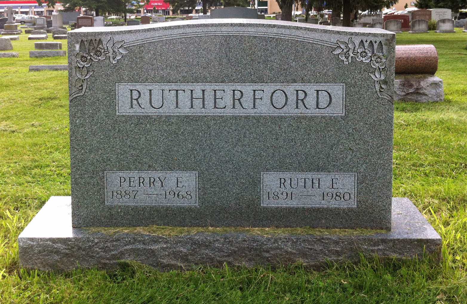
Joe Smith kindly shared this item with me, after discovering it at the Columbus Metropolitan Library. It’s A History of the North Methodist Church, Clinton Chapel, North Columbus by Ruth Ellen (Grove) Rutherford.
Ruth Ellen (Grove) Rutherford [1891-1980], a long-time area resident, wrote the history in 1970. The book includes both some history of the Clinton Chapel Cemetery, some information about the old Beers/Piatt log cabin and its move to 40 E. Norwich Ave, and info about the Underground Railroad activities of Pyrum and Polly Hunt. Joe was pleased to see mentions of his own ancestors including the Hunts–Joe’s grandfather Smith‘s maternal 2nd great-grandparents (page 16)–and his grandfather’s maternal grandparents, Horace and Sarah Theresa Young, and his mother, Minnie Belle Young, who are listed as members of North M.E. Church (page 24) in 1898. Minnie married Joe’s great-grandfather, Roy Ripley Smith, a year later, on 20 Sep 1899.
As Joe says, this is a poignant message how the Clintonville community came together and rallied around a greater cause. It’s a message of inspiration just as relevant 142 years later.
[Courtesy of Joe Smith, and the Rutherford family.]Joseph Wilton Smith & Ancestors
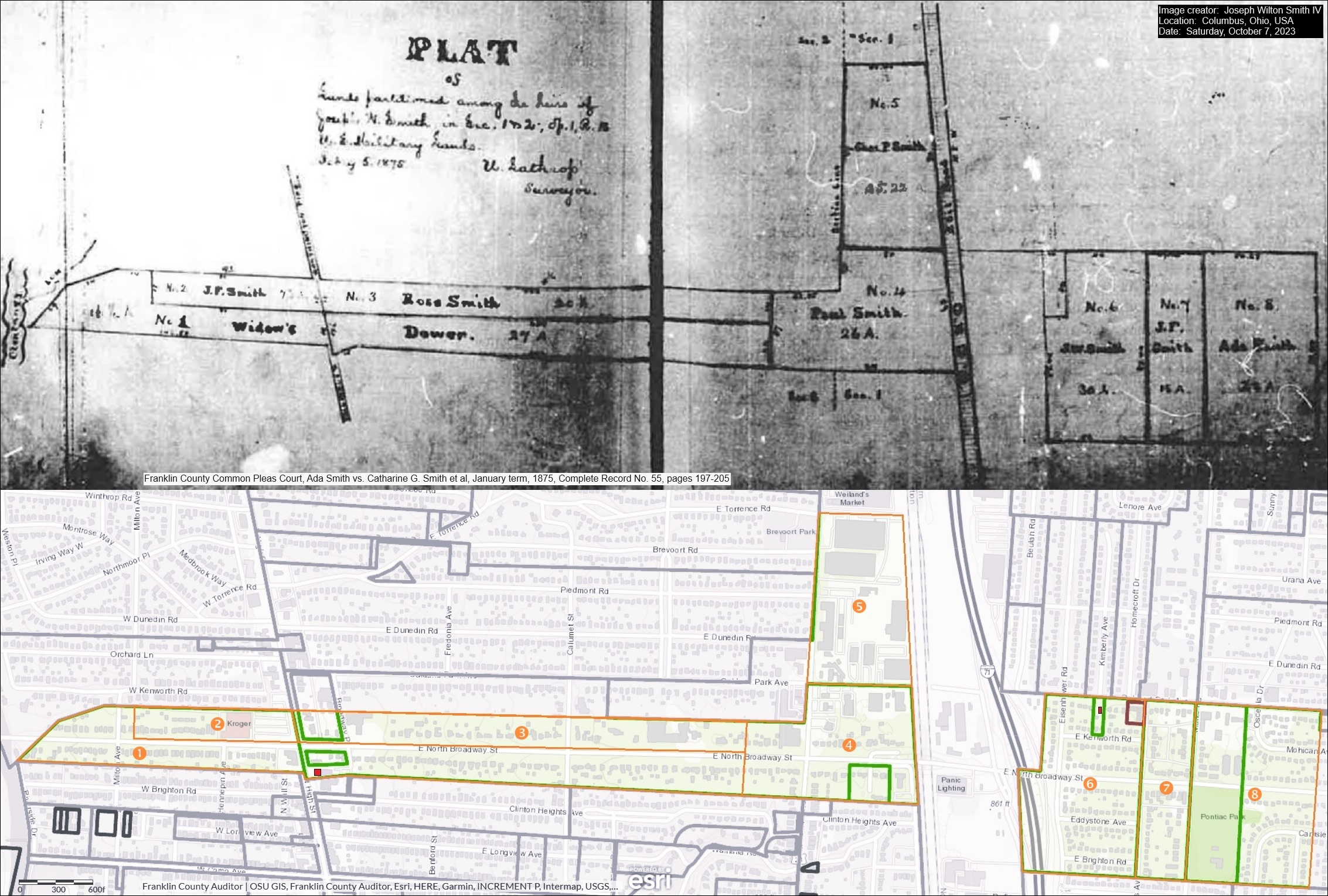 Joseph Wilton Smith IV recently contacted me. Joe’s ancestors owned a house at the southeast corner of East North Broadway and North High Streets, perhaps where the Cochran House was before it was demolished…or–as Mary Rodgers speculated in the May 2020 CHS Newsletter– possibly that very house. Joe has kindly sent along an image that includes several maps:
1) An 1875 map of the legal division of Joseph Wilson Smith’s farmland in Clintonville, Ohio to his heirs
2) A modern map extracted from the website of the Franklin County Auditor that outlines these lands in orange over the current Clintonville area streets. And,
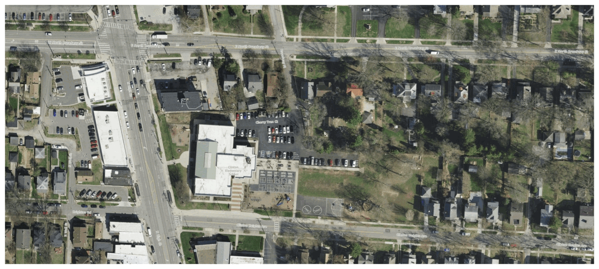
3) The property lines from the 1910 Baist map superimposed on the 2023 satellite view of E.N Broadway and N High.
Joe writes:
I am a direct descendent of three early Clintonville settlers: Thomas Bull, Deacon John Smith, and Pirum Hunt.
I am named after my grandfather, who was named after his grandfather, who was named (sort of) after his father, Joseph Wilson Smith. His wife, Catharine Gray (Piatt) Smith was my third great-grandmother. For the past three months, I have been working closely with Mary Rodgers to sponsor a historical marker honoring my ancestors and their contributions to early Clintonville. My great-grandfather was Roy Ripley Smith, who lived at 145 W. Royal Forest Blvd. in Beechwold. My dad told me Roy also owned a farm that later became part of Highbanks Metro Park.
 In January 2024, Joe Smith gave a presentation to the Clintonville Historical Society about his ancestors, and most especially his ancestor Deacon John Smith. John was a churchman and also an abolitionist in our area. Joe’s presentation is also a great example of what you can do if you set about researching your family’s history.
Joe’s presentation can be found here. The handout for that presentation can be found here.
Thanks Joe!
[Thanks to Joe Smith for sharing his research and his presentation. He welcomes additional information and input on his research, and extends his thanks in advance. Contributors to his research include Sharon Hendershot, Nancy J. Pendleton, Mary Rodgers, Elizabeth Renker, and Kathie Smith Brzoska.]James (Jerry) Welsh, Dairyman
Here’s a very sad story about one of our Clintonville residents from former times. James Welsh, commonly called Jerry, was a dairyman along High Street. His farm burned on January 27, 1897, and Jerry was himself badly burned in the fire. Jerry survived the fire, however, and he eventually died on Sept 5, 1905 at the age of 72 or 73 of dropsy (edema, or heart failure). He was originally from Ireland, was a Civil War veteran, and is buried in Mount Calvary Cemetery.
There’s no record of his having owned a farm on High Street or in Clinton Township, so perhaps he leased the farm land. When he died, Jerry lived at 34 Richards Road with his wife Bridget; I presume he lived close to his dairy farm. The couple also lived with a lad named Fay Osborn; Osborn is likely the 14-year old boy who was also at the scene of the 1897 fire and who was credited with saving the 20 cows.
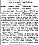
Dairy Barn Burned
Cows Saved With Difficulty From the Flames–Loss $900.The big dairy barn of Jerry Welsh on High street above Clintonville was totally destroyed by fire Tuesday afternoon, together with a stock of fodder. In the barn at the time the blaze was discovered were about 2[0] cows and some horses. All the animals were finally removed though Welsh and his neighbors had a lively time of it taking the frantic beasts from the fiery furnace.
Luckily there was little, if any, wind and the other outbuildings and the house were saved.
There was no means of fighting the fire, and all that could be done was to run to the neighbors’ for buckets of water to pour upon the house. About [6]00 tons of millet was burned. The loss on the property will be about $900.
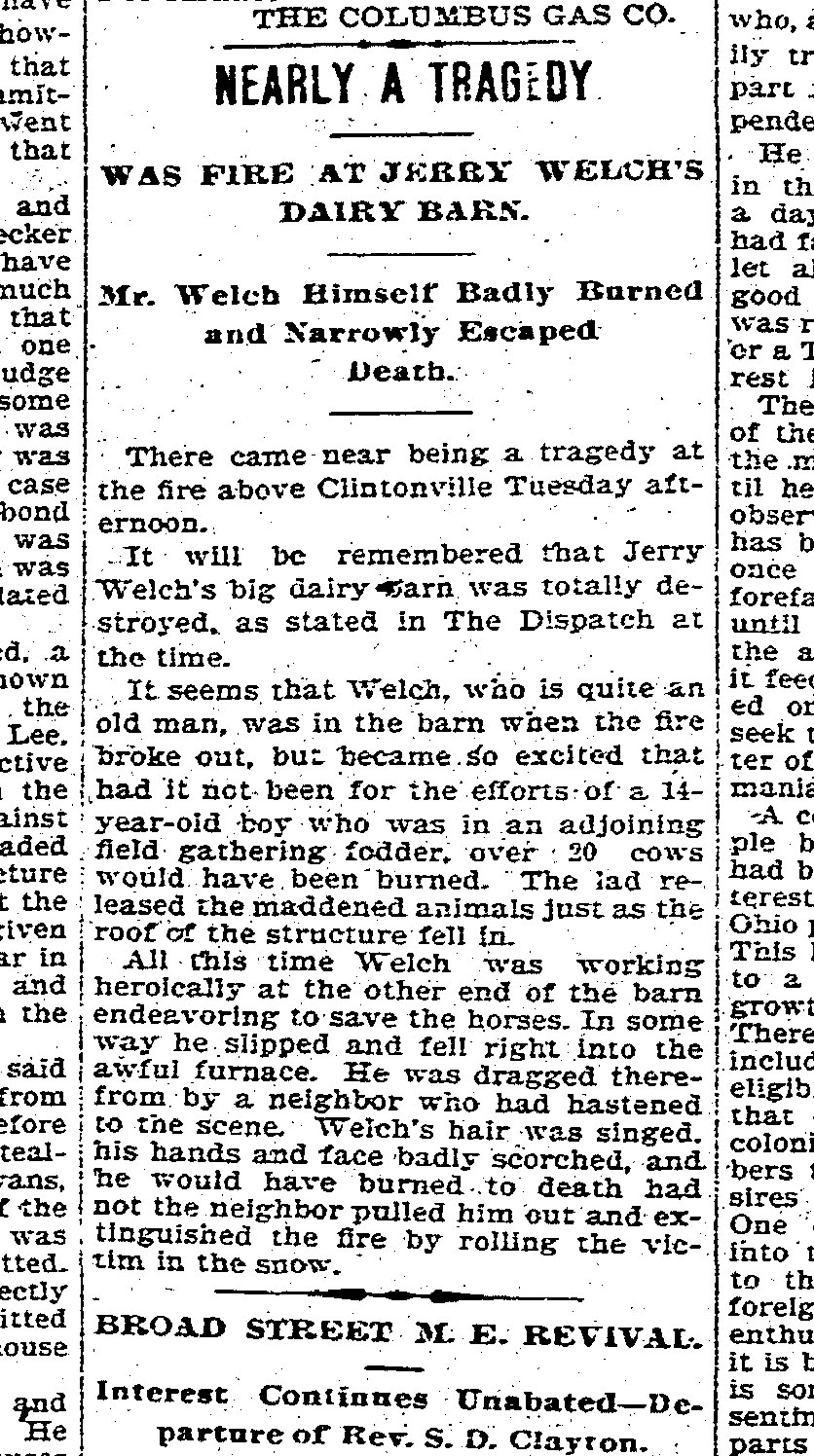
Was Fire at Jerry Welch’s
Dairy BarnMr. Welch Himself Badly Burned And Narrowly Escaped Death
There came near being a tragedy at the fire above Clintonville Tuesday afternoon.
It will be remembered that Jerry Welch’s big dairy barn was totally destroyed, as stated in The Dispatch at the time.
It seems that Welch, who is quite an old man, was in the barn when the fire broke out, but became so excited that had it not been for the efforts of a 14-year-old boy who was in an adjoining field gathering fodder, over 20 cows would have been burned. The lad released the maddened animals just as the roof of the structure fell in.
All this time Welch was working heroically at the other end of the barn endeavoring to save the horses. In some way he slipped and fell right into the awful furnace. He was dragged therefrom by a neighbor who had hastened to the scene. Welch’s hair was singed, his hand and face badly scorched, and he would have burned to death had not the neighbor pulled him out and extinguished the fire by rolling the victim in the snow.
Cindy at the Columbus Metropolitan Library shared most of the above details about Mr. Welsh with us. She writes: “I was able to find a little more information about Jerry Welsh. First, I believe the name was actually Welsh, not Welch [as in the 2nd article above]…I am attaching Mr. Welsh’s obituary. I was able to find him on the 1900 census with his wife, and it looks like he was a veteran of the Civil War because I found a grave registration card that matches up with his grave information in Mount Calvary Cemetery. Unfortunately, I was not able to find that he owned any property in Clinton Township. I checked maps, including a 1895 plat map that has landowners names on it. I also checked deed indexes on the recorder’s site for that time frame for both grantors and grantees and still did not find anything. It is possible he was renting the land that the barn was on.”
I do love our Columbus Metropolitan Library System and especially appreciate the Local History and Genealogy staff. THANK YOU CINDY!
A Little Bit of Sewage Goes a Long Way
Last month I provided a glimpse of James Chesnut, who lived at 3338 N. Wall Street. James Chesnut was involved in significant litigation with the North Broadway developers and neighbors. Though last month I said James appears to have been irascible, I’d certainly be that way too if this happened to me. From the Dispatch:
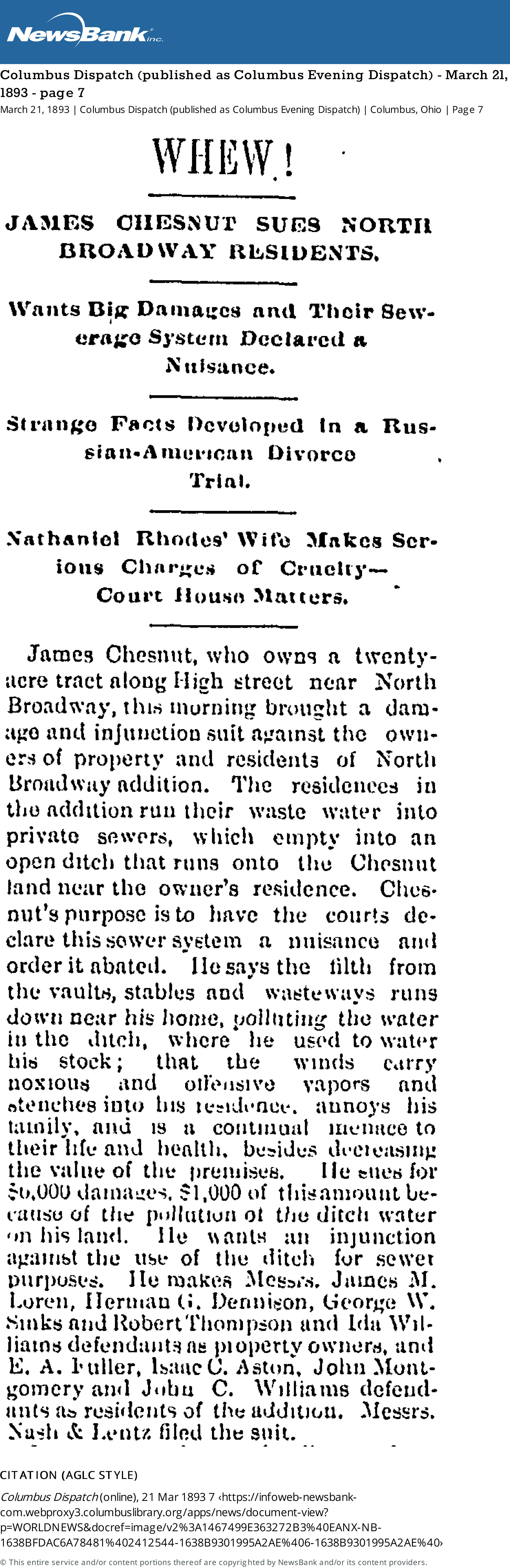
[From Columbus Dispatch (published as Columbus Evening Dispatch) March 21, 1883 page 7.]Whew!
James Chesnut Sues North Broadway Residents
Wants Big Damages and Their Sewerage System Declared a NuisanceJames Chesnut, who owns a 20-acre tract along High Street near North Broadway, this morning brought a damage and injunction suit against the owners of property and residents of North Broadway addition. The residences in the addition run their waste water into private sewers, which empty into an open ditch that runs onto the Chesnut land near the owner’s residence. Chesnut’s purpose is to have the courts declare this sewer system a nuisance and order it abated. He says the filth from the vaults, stables, and wasteways runs down near his house, polluting the water in the ditch, where he used to water his stock; that the winds carry noxious and offensive vapors and stenches into his residence, annoys his family, and is a continual menace to their life and health, besides decreasing the value of the premises. He sues for $6,000 damages, $1,000 of this amount because of the pollution of the ditch water on his land. He wants an injunction against the use of the ditch for sewer purposes…
A couple months later, the North Broadway developers issued a rejoinder:
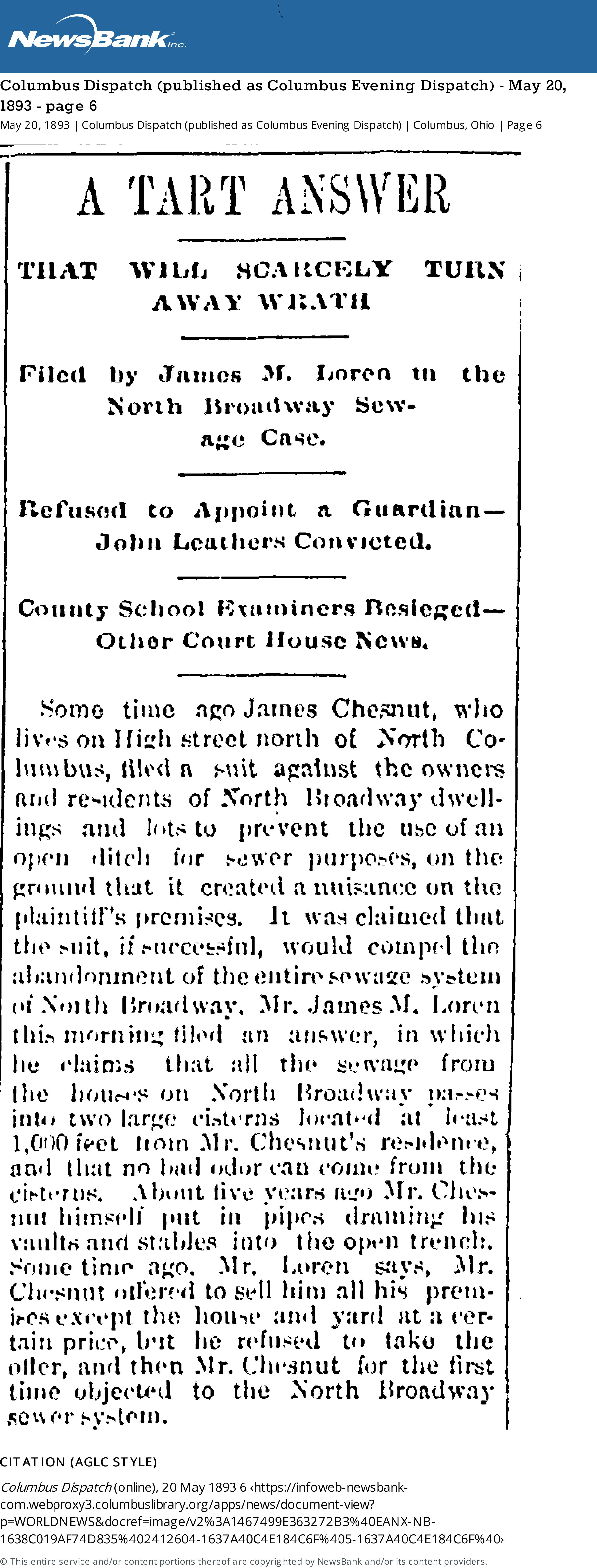
A Tart Answer
That Will Scarcely Turn Away Wrath
Filed by James M. Loren in the North Broadway Sewage CaseSome time ago James Chesnut, who lives on High Street north of North Columbus, filed a suit against the owners and residents of North Broadway dwellings and lots to prevent the use of an open ditch for sewer purposes, on the ground that it created a nuisance on the plaintiff’s premises. It was claimed that the suit, if successful, would compel the abandonment of the entire sewage system of North Broadway. Mr. James M. Loren this morning filed an answer, in which he claims that all the sewage from the houses on North Broadway passes into two large cisterns located at least 1,000 feet from Mr. Chesnut’s residence, and that no bad odor can come from the cisterns. About five years ago, Mr. Chesnut himself put in pipes draining his vaults and stables into the open trench. Some time ago, Mr. Loren says, Mr. Chesnut offered to sell him all his premises except the house and yard at a certain price, but he refused to take the offer, and then Mr. Chesnut for the first time objected to the North Broadway sewer system.
[From Columbus Dispatch (published as Columbus Evening Dispatch) May 20, 1883, page 6.]
Apparently Loren’s response was not accepted by the courts, for this article followed along in 1897:
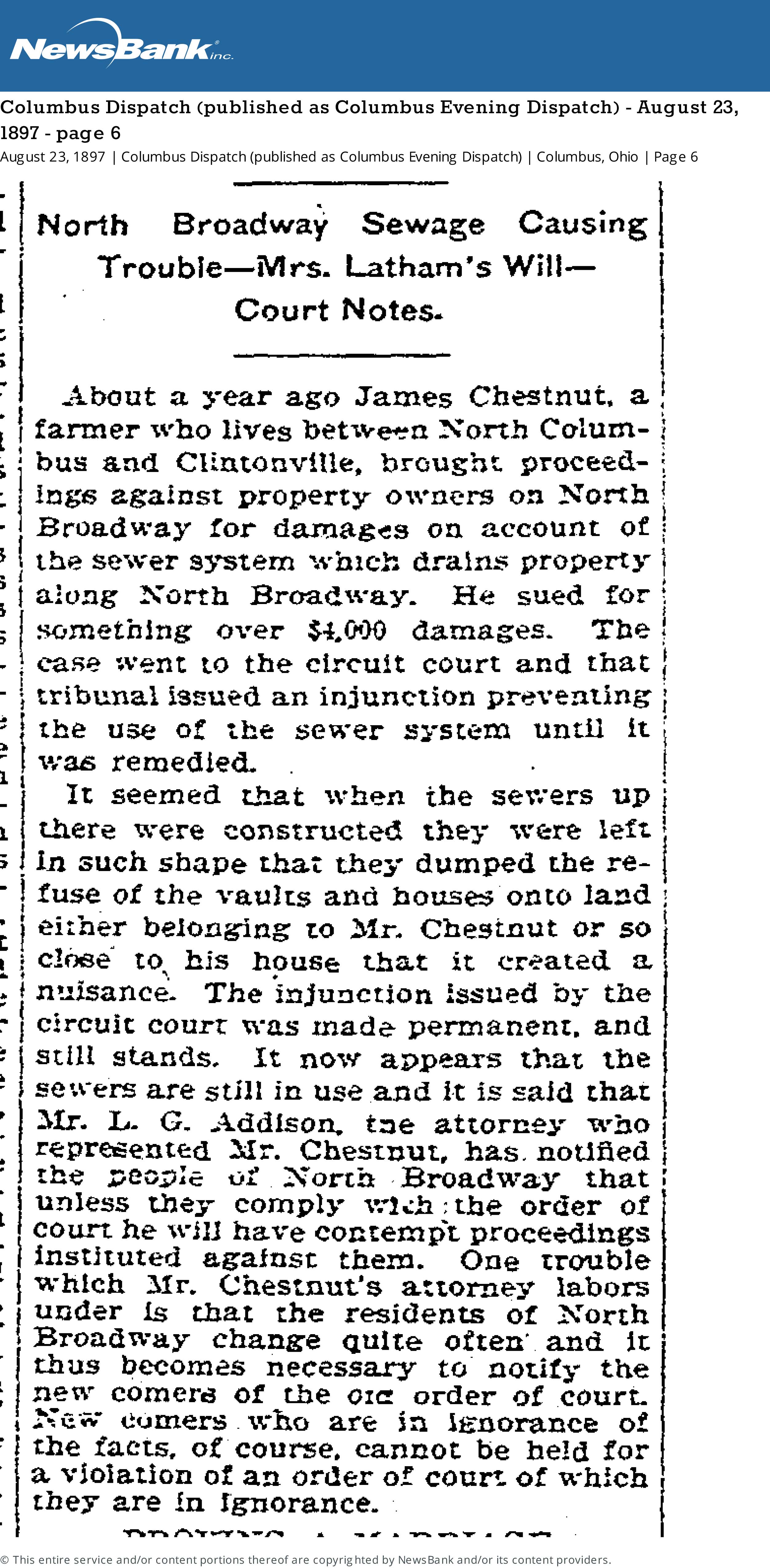
[From Columbus Dispatch (published as Columbus Evening Dispatch) Monday August 23, 1897 page 6.]North Broadway Sewage Causing Trouble
About a year ago James Chestnut, a farmer who lives between North Columbus and Clintonville, brought proceedings against property owners on North Broadway for damages on account of the sewer system which drains property along North Broadway. He sued for something over $4,000 damages. The case went to the circuit court and that tribunal issued an injunction preventing the use of the sewer system until it was remedied.
It seemed that when the sewers up there were constructed they were left in such shape that they dumped the refuse of the vaults and houses onto land either belonging to Mr. Chestnut or so close to his house that it created a nuisance. The injunction issued by the circuit court was made permanent and still stands. It now appears that the sewers are still in use and it is said that Mr. L. G. Addison, the attorney who represented Mr. Chestnut, has notified the people of North Broadway that unless they comply with the order of court he will have contempt proceedings instituted against them. One trouble which Mr. Chestnut’s attorney labors under is that the residents of North Broadway change quite often and it thus becomes necessary to notify the new comers of the […] order of court. New comers who are in ignorance of the facts, of course, cannot be held for a violation of an order of court of which they are in ignorance.
An Old Chestnut…or Rather, Chesnut
 Occasionally, the name of a local figure pops up with frequency, and one forms an image of, well may I say, an irascible neighbor? James Chesnut (often spelled “Chestnut”) is one of those guys; see other posts about him here.
Who was this guy, anyway? James Chesnut was born in Ireland on May 1, 1820, and he died at age 85 on May 26, 1905. Census records say James was a “machine sawyer,” “works in coal factory”, or “foreman and tool shop”. He seems to have owned 20 acres on North High Street. His wife was Christiana McEwan (b. Dec 24, 1825, d. Jul 14 1891). (One source says “Ewing” but I believe that’s wrong.) She is buried with James in Greenlawn Cemetery. Some census records say Christiana was born in England or Ireland, and there’s also a record that says her father lived in Ridgeway, PA.
James and Christiana had a daughter (one census record says “adopted daughter”), Fannie, who was born around 1854/55. She lived with her parents and seems to have remained single. She continued to live in the North High Street (now Wall Street) house through 1910, but by 1914 she’d moved to 2103 Summit Street. She lived there until her death in March 1932; she died at age 78 in University Hospital of injuries suffered when she was hit by a taxi the previous December. (Her obituary also names a sister, Jennie Reid, who lived in Bridgeport Connecticut.)
I love the Chesnut house, still in existence at 3338 N. Wall Street.
Great Sale of Live Stock
Last April 2021, I posted an article by Clintonville Historical Society President Mary Rodgers, about the Clintonville Woman’s Club. The club was built on land that was once owned by a “horse trader” named E. A. Fuller.
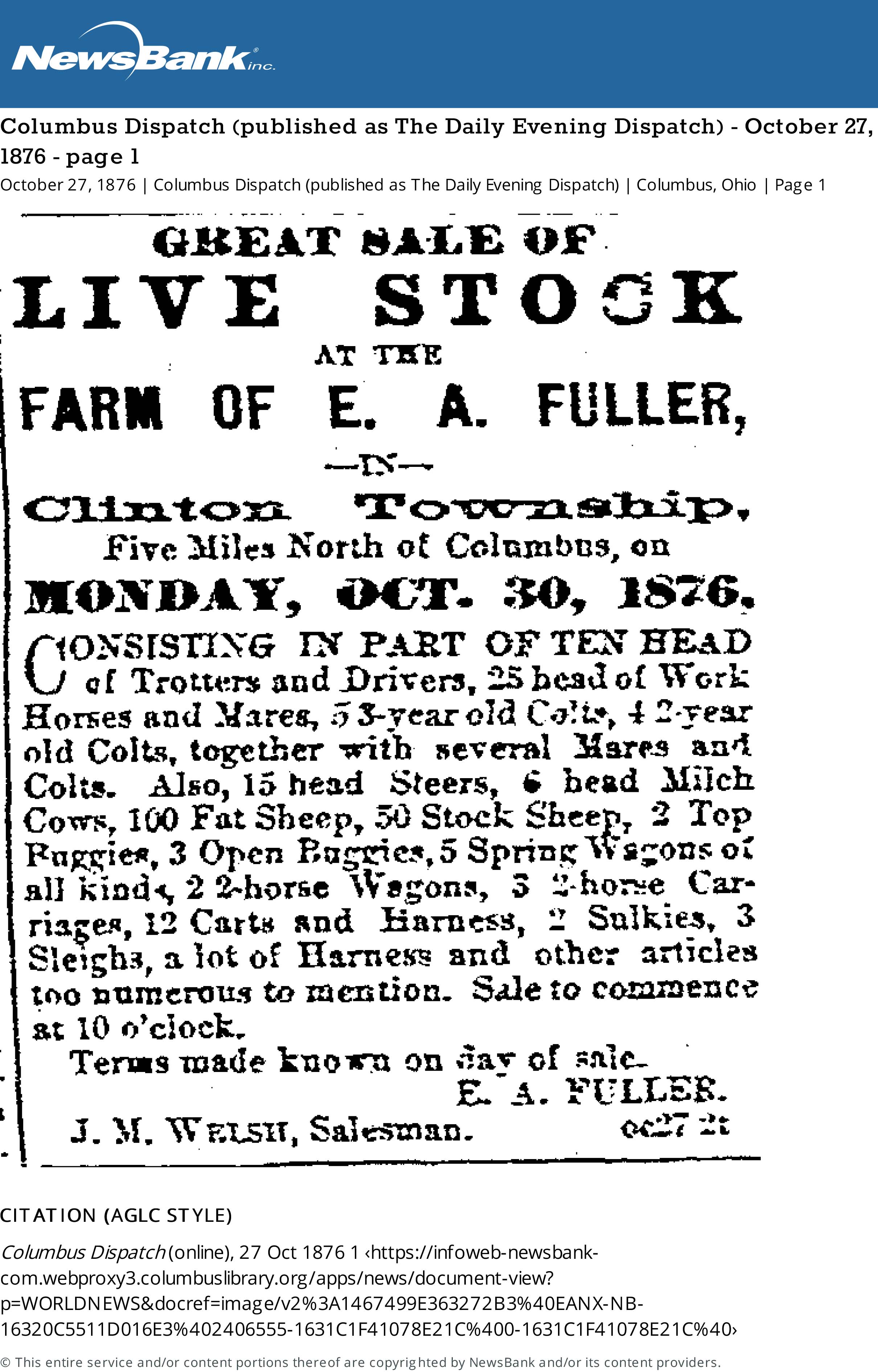 I recently found some old advertisements for horses–bought, sold, stabled–at E.A. Fullers Farm. Here’s one of them from the Columbus Dispatch (published as Columbus Evening Dispatch) October 27, 1876, page 1.
(I’m glad it was not a sale of dead stock.)
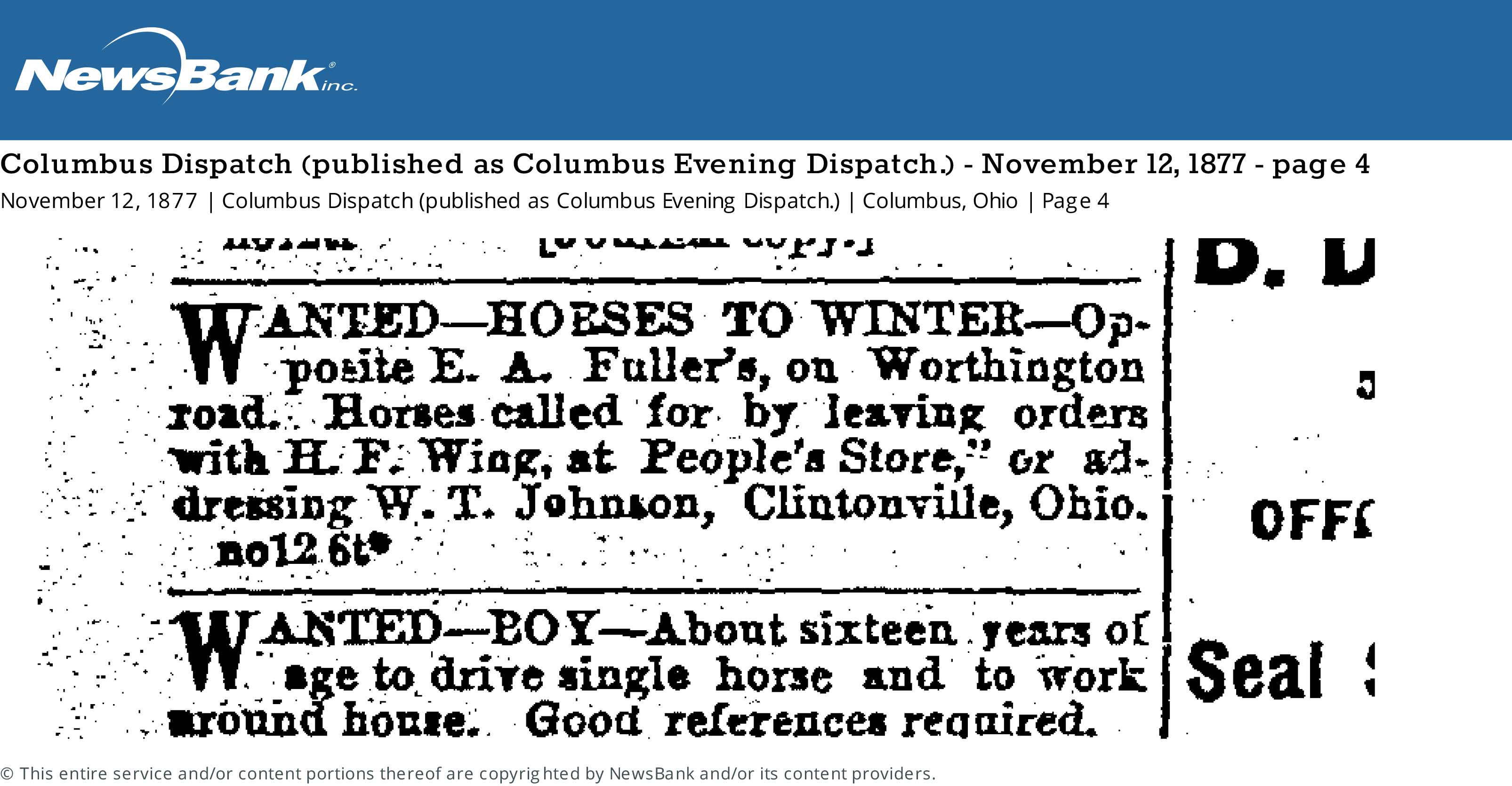
There are many more ads; here’s one for stabling horses near E.A. Fulller’s farm from the Columbus Dispatch (published as Columbus Evening Dispatch) November 12, 1877 page 4.
The Dispatch has lots of other ads as well, especially from 1902, for stabling horses at the Fuller farm. They’re great reminders of Clintonville’s agricultural past.
[Thanks to the Columbus Metropolitan Library for making the Digital Columbus Dispatch available and searchable online on CML’s web site.]The First Post Office
 If you have not yet joined the Clintonville Historical Society, well, you ought to! Mary Rodgers sends out an interesting monthly newsletter that is chock-a-block full of good articles. In the October 2017 issue, she penned an article about Clintonville’s first post office.
Celebrating 170 years: The first Post Office
by Mary Rodgers
October 2017
We celebrate Clintonville’s birthday on September 13, 1847. That is the day that a post office opened using the name “Clintonville”. We know that the small town between Columbus and Worthington existed prior to the date but because the town was never formally platted, we do not have an alternative formal start date. On September 13, 1847, James Ferguson was appointed postmaster at the Clintonville Post Office. It was the practice at the time to locate the post office in a business operated by the postmaster. The names of the offices were determined by the postmaster and were usually associated with the area that they were located, the postmaster’s name or the postmaster’s business. In 1933, The Booster printed a photo of the post office. That photo is of a rug store! Mr. Ferguson was a blacksmith. Maybe he had a side operation?
Or, maybe this photo captured the building where Clintonville’s second postmaster set up operation? Harmon “Hammer” Houck was Clintonville’s second postmaster. He reigned from November of 1852 to April of 1854. The 1850 census lists him as a peddler. That might be consistent with a rag rug dealer.
James Ferguson reclaimed the position of postmaster in April of 1854. He and family originated in Lancaster Co. Pennsylvania. He was the son of John and Susanah (Hood) Ferguson. James was married to Hannah Murray around 1824. The Fergusons, at least three generations, came to Ohio in 1843. They arrived by wagon (note: Lancaster County, Pa is the birthplace of the Conestoga wagon!). Based on area maps, James purchased his Clintonville property from Alanson Bull. A question would be: How did Ferguson become aware of Bull’s interest in building a town? Did Bull run advertisements in Eastern newspapers of the time? That is a question for another day.
According to the 1850 Census, James Ferguson owned 5 acres of land, a home, two milk cows, a beef cow, five pigs, and 100 bushels of corn. His livestock was valued a $98, his machinery at $41 and his overall estate at $950. His estate was higher in value then his neighbors with more land. Perhaps that is an indication of its geographical position “in town”? Hannah Murray Ferguson, James’s wife, was a Quaker. Quakers were known to be involved in the Underground Railroad and the Fergusons are a part of the Clintonville Underground Railroad story. The Ferguson sons Joseph, John and Samuel all served in the Civil War. His son Joseph died in action in Perryville, KY. According to K. Haefner, 3rd great granddaughter of Hannah and James Ferguson, when sons John and Samuel returned from the war, the family moved to Findlay, OH. It would seem that John and Samuel met a number of men from Hancock County while serving. Those men told stories of the land and those tales impressed these young men. In Findlay, Samuel and John pursed wagon making. The shop they opened remained in operation beyond 1911.
The Clintonville Woman’s Club: the women before the Clubhouse
 Mary Rodgers has written a very nice article about the Clintonville Woman’s Club.
The Clintonville Woman’s Club: The Women Before the Clubhouse
by Mary Rodgers
[Courtesy of Mary Rodgers]I was recently asked to speak at an evening meeting of the Clintonville Woman’s Club. Specifically, I was asked to speak on the subject of the history of the land that the Clubhouse occupies. I have always understood that the Clubhouse was located on land from the old Fuller Farm. I was surprised to learn more about the “Fuller” family.
In the 1820s, John Rathbone sold farm lot 5 to Edward Amaziah Stanley. Using today’s landmarks, that land would have been bounded on the east by Indianola Avenue, on the west by the river, on the south by roughly Torrence Road and on the north by roughly Overbrook Drive. When Mr. Stanley died in 1862, his land holdings were passed down to his children. Harriet Marie Stanley (aka Hattie) was one of those children. She was born in Connecticut in 1831. Based on the extensive land holdings throughout Ohio, I believe her father Edward was an Ohio land speculator. After acquiring several thousand acres, in 1829, he returned to Connecticut to marry Abagail Talcott Hooker. Sometime between 1831 and 1834, the family moved to the Clintonville area.
In 1856, Hattie married Erskine Asa Fuller, aka E. A. Fuller. E. A. was known as a dealer in stock animals. When her father passed away, Hattie inherited all of farm lot 5 in Clinton Township Ohio. The 1870 census shows a large extended family living together in Clintonville–the Fullers and their daughters, Hattie’s mother, brother, sister, and several farm hands and servants. The combined household value per that census was in excess of $25,000. Hattie passed away in 1879. E.A. passed away in 1894. After their deaths, the farm was transferred equally to the four Fuller daughters–Abby, Mary, Katherine and Martha.
Martha Fuller and her sister Katherine Fuller Peters lived all of their lives in Clintonville. They owned two brick homes along High Street–Katherine’s just south of where the Library sits today and Martha’s where the Christian Science church sits today. Martha Fuller passed away in 1938. She left half of her land holdings to long time farm hand Matthew McCallen and half to her niece (sister Mary’s daughter) Helen Osborn.
Eventually, all the land was sold off, some to the Christian Science Church, some to the Calvary Bible Church, and the balance to the City of Columbus.
The Clintonville Woman’s Club land was purchased by the Kiwanis Club of Northern Columbus. That Club loaned the ladies the funds needed to build the Clubhouse. In turn, they held a mortgage on the property. The Woman’s Club members worked tirelessly and retire their debt to the Kiwanis within five short years! They have owned the Club house and property ever since.
Balser Hess Family Graves
 Mary Rodgers, President of the Clintonville Historical Society, did some wonderful research on the Balser Hess family graves at Union Cemetery, in response to a reader’s inquiry about this post. Apparently the reader believed that Balser Hess’s wife is not buried in this location despite the tombstone.
 From Mary Rodgers:
[Images courtesy of Mary Rodgers]There are lots of burials on the Hess property prior to the establishment of the Union Cemetery Association in 1847. The Association purchased the Hess burial ground in 1862. The only known records of the early burials are the tombstones. Unfortunately, there are lots of illegible and missing stones.
Union Cemetery and the Historical Society believe Balser to be the earliest burial. The family arrived in Ohio around 1799. They had a child (John) born in Hopetown in 1799. He lived to adulthood. Attached is a family history that was done many years ago by Frank Hess. It states that Balser was the first burial on the family farm. I confirmed that John was the last of George’s children; she didn’t find any grandchildren prior to his death in 1806.
Balser’s wife (Mary Eva) is represented on the tombstone. We have no reason to believe that she is not buried at Union. The property was still in the family’s control at the time of her death. The tombstone that is in the cemetery is not the original. It was lost to the test of time and replaced by the family.
John was the last child to be born to Balser and Mary Eve. No mention of “lost infants” for that couple.
The only child of Balser who married prior to his death was his daughter Mary Ann. She married Henry Cryder before the Hesses moved to Franklinton. She and Henry ultimately moved to Delaware, OH (then to Illinois) but I don’t see anything that would suggest they had a child that would have been buried on the family homestead in Franklin Co. prior to her father’s death. At that time, they lived in New Hope, OH.
Calling Doctor Amy!
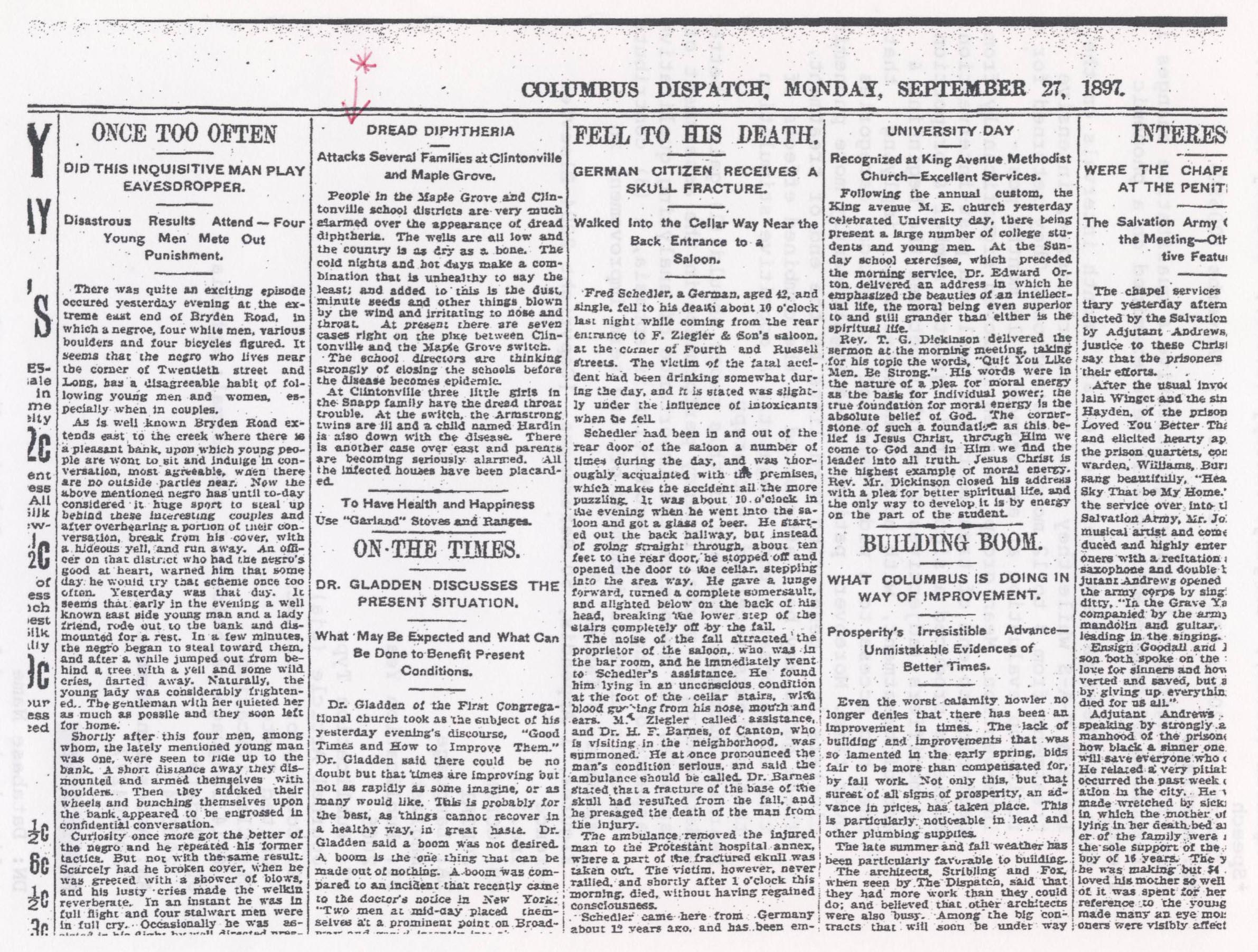 This is a Columbus Dispatch article, dated September 27, 1897, about an almost-epidemic of diphtheria. Though you can zoom in, the print is tiny, so I’m providing the text here:
“Dread Diphtheria Attacks Several Families in Clintonville.
“People in the Maple Grove and Clintonville school districts are very much alarmed over the appearance of dread diphtheria. The wells are all low and the country is as dry as a bone. The cold nights and hot days make a combination that is unhealthy to say the least; and added to this is the dust, minute seeds and other things blown by the wind and irritating to nose and throat. At present there are seven cases right on the pike between Clintonville and the Maple Grove switch.
“The school directors are thinking strongly of closing the schools before the disease becomes an epidemic.
“At Clintonville three little girls in the Snapp family have the dread throat trouble. At the switch, the Armstrong twins are ill and a child named Hardin is also down with the disease. There is another case over east and parents are becoming seriously alarmed. All the infected houses have been placarded.”
According to Wikipedia and the CDC, diphtheria is an infection caused by the bacterium Corynebacterium diphtheriae. Signs and symptoms vary from mild to severe. They usually start two to five days after exposure. Symptoms often come on fairly gradually, beginning with a sore throat and fever. In severe cases, a grey or white patch develops in the throat; this can block the airway and create a barking cough as in croup. The neck may swell in part due to enlarged lymph nodes. Complications may include myocarditis, inflammation of nerves, kidney problems, and bleeding problems due to low levels of platelets. Nowadays, children are vaccinated against diphtheria in combination with tetanus and pertussis.
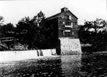
Old Piatt Mill
 This lovely mill was located on the river, just north of the present Dodridge Street bridge. There is another photo of this, in my book.
The original dam and mill were constructed by David Beers in 1810. Beers owned the land on which the mill was located. Darius Wilcox built a sawmill adjacent to the flour mill. The mills later came to be owned by the John James Piatt family. The buildings burned down on June 13, 1902. The area just to the east and north is where Olentangy Amusement Park was located.
[Image courtesy of Galen Gonser]J. Harvey Zinn & Family
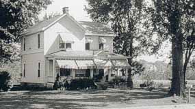
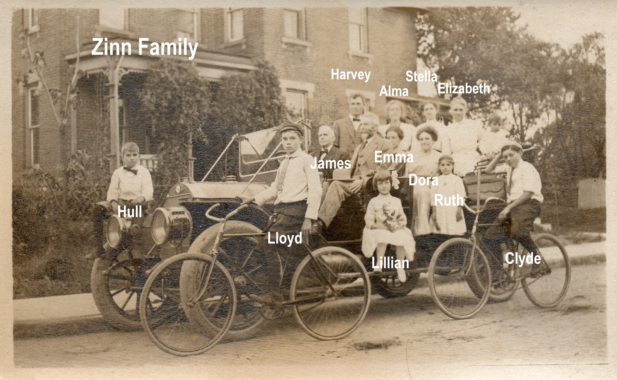 J. Harvey Zinn, owner of the Zinn lumber yard, lived in Clintonville and was a civic leader and philanthropist. Mr. Zinn was reported to be an ardent fisherman who followed his favorite sport in practically every part of Canada, as well as in Florida waters. His attractive estate “Edgewater,” was located at 285 Kenworth on the Olentangy River just north of West North Broadway. This estate still exists in Clintonville.
J. Harvey Zinn died in 1957.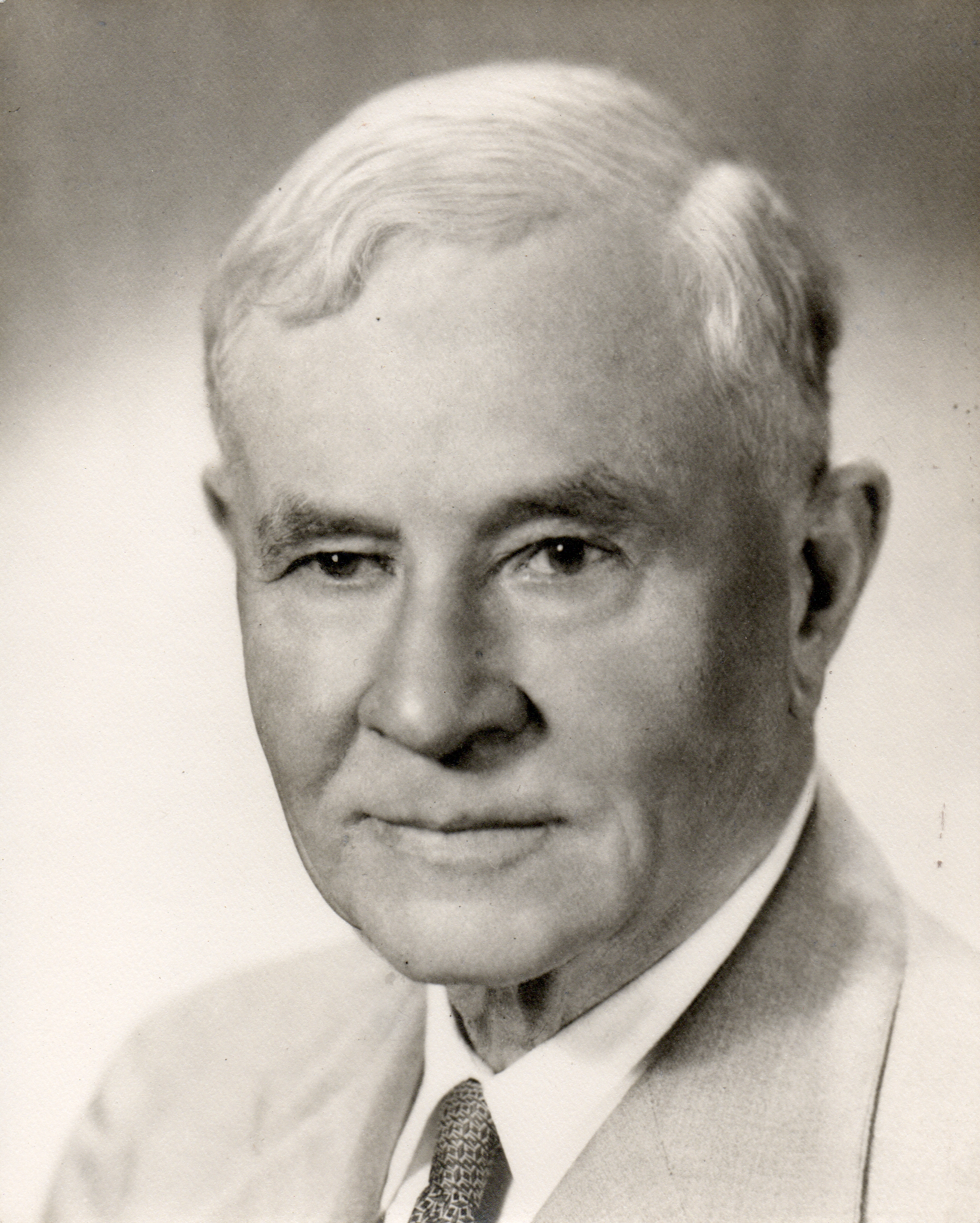
Attached are some obituaries from The Columbus Dispatch and elsewhere.
The Zinns were very active in the North M. E. Church. Though the church is not, technically, in Clintonville, I’ve also posted some information about the church.
[Photos and clippings courtesy of John Clark]Legg Family
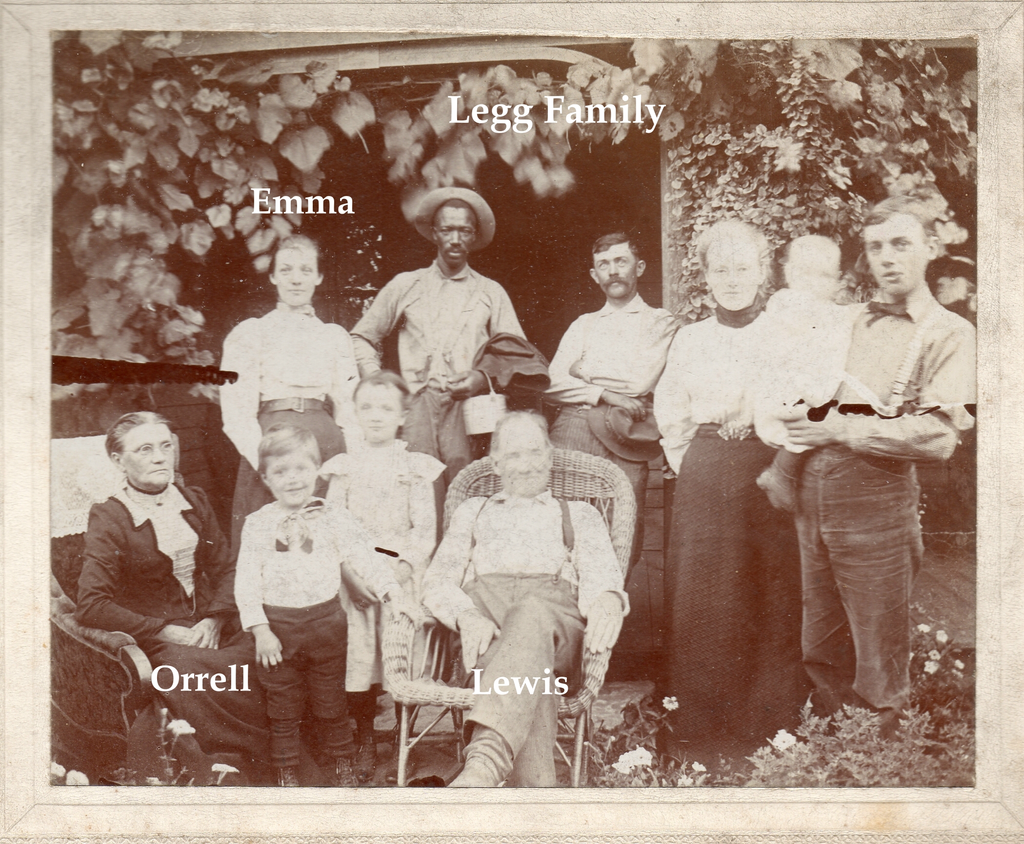
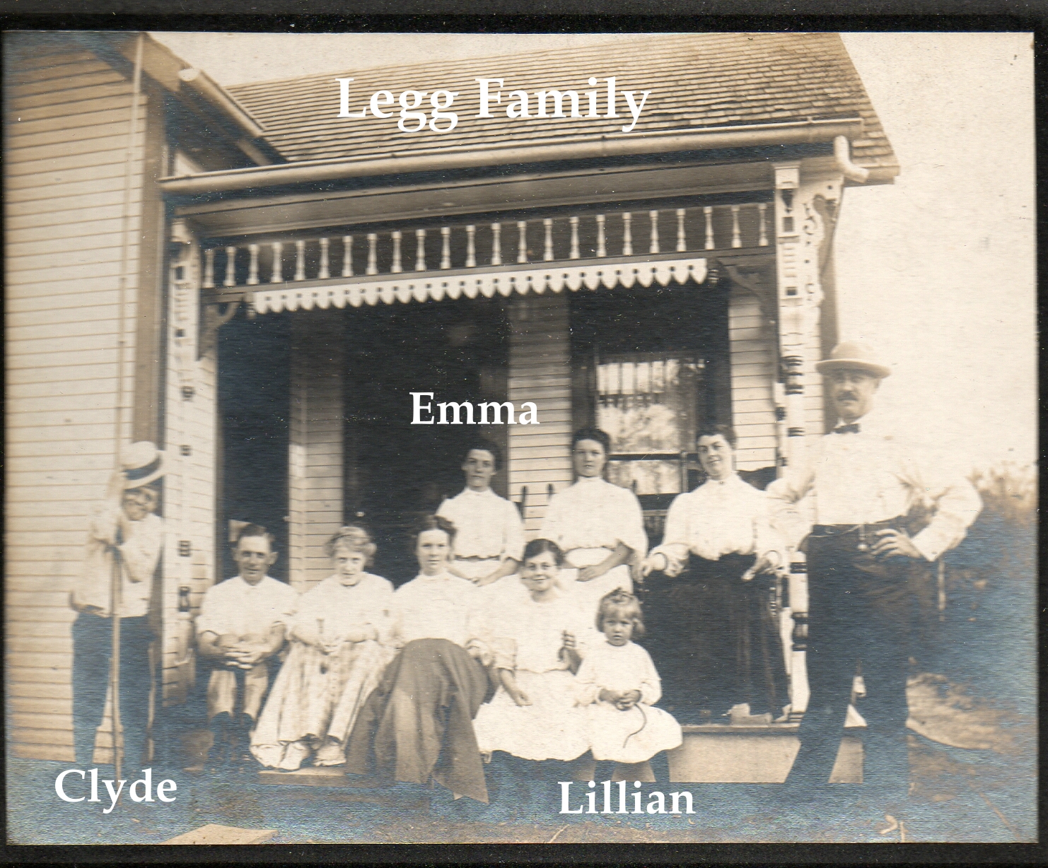
Here are two wonderful pictures of the Legg family. Emma Legg married James Harvey Zinn, born 1 October 1871 Ohio, in 1895. J. Harvey Zinn was the President of the Zinn Lumber Company located at Hudson and North High Streets. Emma and James lived at 285 Kenworth, located on the Olentangy River just north of West North Broadway. (Their house still exists in Clintonville.) [Photos courtesy of John Clark. Thanks also to his wife Lauren for sending them to me.]
For more information on the Leggs see here;
For more information on the Zinns see here;
and/or listen to Robert Ohaver’s oral history.
J. Harvey Zinn & his “Innocent Lamb” Lillian
The Zinn Lumberyard is always interesting; many people I met while researching my book remember it, yet I have never seen pictures of it. James Wells, long-time resident of the Olde North Columbus community has an abiding interest in it and has shared a couple items about the Zinns.
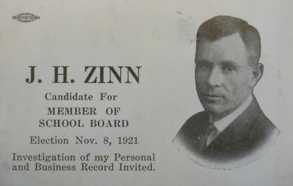 The first is a business card for Mr. Zinn when he ran for the school board in 1921. We’re not sure if he won or not, but it would be interesting to find those records. Don’t you love the directive, “Investigation of my Personal and Business Record Invited.”
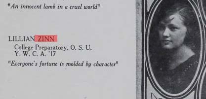 The second is Mr. Zinn’s daughter Lillian’s graduation photo from North High school in 1920. She was described as an “innocent lamb in a cruel world.”
You’ll find more information on the Zinns here.
By the way, James says he is “always interested in anything to do with J.H. Zinn and would appreciate any info about him and his family (or related subjects like his lumberyard, the North United Methodist church, where the family members were life-long attendees) or the Herron/Thornton families who lived across Tompkins street from the Zinn’s.
[Thanks for sharing these images, James!]The Leggs
This is a reprint of an article by Mary Rodgers, originally appearing in the newsletter of The Clintonville Historical Society.
A brief history of Charles T and Sadie M. Legg–long time Clintonville residents–based on The Booster news article dated February 12, 1937, with additions
Charlie Legg was born on the Legg farm on April 23, 1871. This farm, a dairy, was located North of Clintonville. The lane leading to the Legg homestead would have been near where Webster Park Avenue is today.
Charlie’s mother was Orell E. Webster, daughter of Amazon Webster and a direct descendant of Noah Webster of American Dictionary fame. His father was Lewis Legg, believed to be the son (or grandson) of Elijah Legg, a revolutionary war soldier from Massachusetts who settled in Ohio in 1815.
In 1937, Charlie reported that when his grandfather, Amazon Webster, moved to Clinton Township, Indians lived in the section now known as Indian Springs. Those Indians raised cranberries. Amazon told his grandchildren that the Indians would walk to Chillicothe to sell their berries.
Charlie’s grandmother was Mary Pinney of Worthington. She was the daughter of Levi Pinney and Charlotte Beach. Levi and Charlotte were the first couple to be married in Worthington, Ohio. That was 1839.
Sadie Mitchell was born on January 27, 1874 in Circleville. Her father was a builder. She became Charlie’s blushing bride on Thanksgiving Day, November 24, 1892. When she heard of the upcoming wedding, Sadie’s grandmother exclaimed, “Oh that name!” Sadie’s response was that it was no worse than the last four letters of her present name!
The Leggs were married by Rev. Louis Postle and their first home was behind Dr. Burbacher’s Offices, which were located on the Southeast corner of Oakland Park and High. The Mennonite Church stands here today. It was reported that after a year, in 1894, they moved to into a building that had been a church at the Northeast corner of Walhalla and High street (Clinton Chapel–now Southwick-Good and Fortkamp Funeral Home). They started a dairy farm. After a year, they moved to property located west of the Olentangy River near what is now Lane Avenue. Here they set up a “business” farm including the sale of corn to the Sells Circus. Today, if you are driving north on Kenny Road from Lane Avenue, you will see a road called Legg.
When Charlie’s father could no longer care for his farm, Sadie and Charlie combined their operation with his and moved to the North Clintonville homestead. In 1907, the Leggs sold the farm to developers Thompson, Johnson and Thompson. The neighborhood called the Webster Park Addition was platted. The Leggs built and sold three homes in this development. Orell Webster Legg, Charlie’s mother, retain the portion of the farm closest to the river. In 1909, a portion of her property was set aside for a bird sanctuary. We call this area the Delta.
According to the 1914 records, 346 families, a population of 1,190, represented Clintonville. The Clinton League Memory Book reports:
In 1913, a new two story brick building was erected on the corner of Dunedin Road and High Street. It was haled with delight by residents of the neighborhood for at this place Mr. Legg opened a grocery store and Mrs. Legg had a department for notions-live-savers they were where you lived five miles from town. There were two business rooms in this building so the post-office was moved to the one adjoining the store. It remained there until 1917 when rural mail delivery was established.” Today, this building houses Shim’s tailor and Melissa’s Incredible Edibles.
On July 4, 1916, Sadie’s dry goods business moved to 3339 North High. That building was built in 1910 by J. C. Loren. The Booster reported him as a well known contractor at the time. He may have built some of the early homes on East North Broadway. In fact, the home that was located at 615 East North Broadway, the carriage house for that home still stands and is know the Fisher home, was referred to as the Loren home in the Clinton Memory Book. We know that the developer of North Broadway, James M. Loren, never lived on North Broadway, so perhaps 615 was J. C. Loren’s home. Before Sadie, the 3339 North High building was occupied by Swope’s Grocery and Bilikam’s Grocery. Bilikam’s later moved to North Columbus. In 1918, the Leggs bought the building and Sadie operated her dry goods store at the site until February of 1937. Later in life, Sadie lived in the apartment above the store.
Mr. Legg, after selling his grocery, was a city salesman for the E. E. Shedd Mercantile Company and then worked for the L. E. and C. W. Medick Co., Ford Dealers in the Clintonville community. In fact, at her retirement in 1939, Sadie said that to get full enjoyment from her upcoming vacation, she would need a new V8 Model Ford. Charlie commented that he wouldn’t be receiving a commission on the upcoming sale.
The Leggs told The Booster that they recalled when a saloon existed at what would now be the southwest corner of Orchard Lane and High Street (the Kroger parking lot). The story is that while there were a dozen saloons in North Columbus, there were none in Clintonville. Then a man was elected mayor of Columbus who closed the saloons on Sunday. This drove the liquor dealers to move outside the city. In those days there was a “one-mile limit” law which meant that city police could arrest people within one mile of the city limits. So the new saloons were set up, including the one here. The local place did a “land-office business. ” The mayor found out however that the Clintonville saloon was a few feet inside the one mile limit. (The city limit at the time was Mock Rd–now Arcadia Ave.) So, on a Sunday morning he sent the “Black Maria,” as it was called in those days, to get the drunkards and the proprietor. A new mayor reopened the City saloons on Sunday and the Clintonville establishment failed.
When interviewed by The Booster in 1937, the Leggs recalled the tollgate that used to block High Street just north of Arcadia. The gate had a 3 cent per rig fee. They also recalled when “…there was no such a thing in those days as cross streets coming into High Street, except North Broadway. So the cars stopped at numbered stops…a pleasant memory when one thinks again of Stop 6 (now Pacemont–once known as Jason Avenue); Stop 7, (now Como); Stop 8 (North Broadway); Stop 9 Clintonville (Oakland Park). And then the stops were farther apart, and little used until one reached Cooke’s Corners (Cooke Road).”
Charlie and Sadie are buried in Walnut Grove cemetery on the south side of Worthington. Charlie passed in October of 1946 and Sadie in November of 1957.
Side note: One of Charlie’s sisters, Emma, married James Harvey Zinn, born 1 October 1871 Ohio, in 1895. J. Harvey Zinn was the President of the J. H. Zinn Lumber Company of Columbus, Ohio. Mr. Zinn was reported to be an ardent fisherman who followed his favorite sport in practically every part of Canada, as well as in Florida waters. His attractive estate “Edgewater,” was located on the Olentangy River just north of West North Broadway. This estate still exists in Clintonville; for more information listen to Robert Ohaver’s oral history.
[Article courtesy of Mary Rodgers and the Clintonville Historical Society]And More Markers!
Ron Irick recently alerted me to the Historic Marker Data Base. In it are photographs of several additional markers covering Clintonville’s notable people, places and events. The database includes the marker for Rand Hollenback, on Hollenback Drive at Whetstone Park, the Nat’l Register of Historic Places marker for East North Broadway Historic District, and the marker (currently in Powell) for the Grand Carousel which was formerly at Olentangy Olentangy Park.
Ron recently posted the Clinton Township/Clintonville Historic Marker.
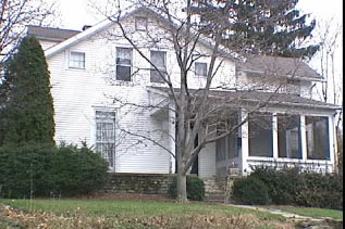
Though not in this database, there is also a marker for the Old Beechwold Historical District. I believe there is also some sort of marker for the former home of the Republican Glee Club at 57 Weber Road.
Underground Railroad in Clintonville
 Debbie Shaw, retired CML librarian, recently provided some local resources about the Underground Railrooad in Clintonville and surrounding area. Thanks for agreeing to share this information, Debbie!
Here’s Debbie’s summary:
-
This link has a short video as well as text below it from WOSU’s Columbus Neighborhood series on Clintonville; both discuss the Underground Railroad.
and this video from the same series on Downtown/Franklinton shows another area involved in the Underground Railroad here in Columbus.
This link is from the Clintonville History site by Shirley Hyatt. The October 2008 issue discusses Thomas Bull and his family and includes a brief section about the Underground Railroad. [Shirley adds: see my book Clintonville and Beechwold here (to buy it) or here (to borrow it) for a smidgen more information.]
Article from the OSU Lantern Feb. 7, 1999.
Historic Marker on OSU Campus.
Another historical marker.
Excerpt from the book The Underground Railroad: An Encyclopedia of People, Places and Operations by Mary Ellen Snodgrass.
For a broader look at the Underground Railroad in Ohio, you can read the full text draft of The Mysteries of Ohio’s Underground Railroad by Wilbur H. Siebert here.
And of course, the Columbus Metropolitan Library has a lot of this history. You can also access a lot online at the here.
Debbie also notes, “This material was easily Googled. As a former librarian, I know that there is a lot of info that is not online. By the way, if you do an advanced book search on books.google.com and limit to full text only and content = books, there are quite a few. I put underground railroad in the ‘with the exact phrase’ field and Ohio underground railroad in the ‘with all of the words’ field. Laws, history, etc. come up, including Ohio Before 1850 and Ohio History Sketches. Of course, some of it is a very brief part of the book. If you add Ohio into the search’s ‘subject’ field, this narrows it a lot.”
Sewer pipe factory, and The Mystery of the Pond
 John Krygier found a few maps that he was kind enough to share with us: 3 Sanborn maps of the sewer pipe factory (and later, brick yard) formerly occupying the area where old North High currently sits at 100 Arcadia. Interestingly, the ravine behind the factory was apparently dammed, making a significant (and the only?) pond in Clintonville (not sure if the one in Whetstone counts). John requests that if anyone knows of any other sources documenting this pond, to let him know. You can do that by commenting on this post and I will send it along to John.
John also found a map showing the rail grade that connected the sewer pipe factory to the main RR line to the east. The interurban (Columbus, Marion and Delaware) used part of that spur (north of Glen Echo Park) as a bypass.
This Worthington Bypass went from Indianola Ave, east along the top of Glen Echo, then north up what is now the alley along the RR track, then curved west at North Broadway over to and running parallel along Indianola. This curve is preserved in some of the lots around Oakland Park–in particular, the odd orientation of the IndiaOak Tavern is the result of it being built on a curved parcel, part of the old RR right of way. A map of current parcels (with the approximate route of the RR grade) is also attached.
There are 7 photos of this Worthington bypass around the time it was built, showing the eastern end of C-ville at the time, at this web site.
Thanks, John!


(Photos courtesy of John Krygier)
Weisheimer Mill
 Another great image of Weisheimer Mill! The verso of this photograph says, “Looking east across the Olentangy River at the Weisheimer Mill N. of Henderson Rd Columbus, Ohio. House and shed are still there at end of Weisheimer Road. (Photo courtesy of Galen Gonser)
Beginnings
 Balser Hess, a cordwainer, tanner and Revolutionary War veteran, was one of the first pioneers to arrive in Clinton Township. Hess came to Ohio with his family and bought 320 acres of land along the west bank of the Olentangy River. His first house, a log structure, was a common stopping place with travelers. Balser died in 1806 and was the first to be buried on the grounds that became Union Cemetery. (Photo courtesy of Terry Miller.)
David Beers
 David Beers was another early pioneer with an exciting life story of having been captured and released by the Native Americans. Beers came to Ohio in 1802. Descendents of David Beers still live in the area to the present day. (Photo courtesy of Terry Miller)
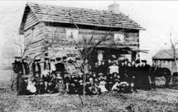 Beers had a log house near the intersection of Dodridge and North High Street. The cabin still exists but has been moved to Norwich Avenue. This photo appeared in the December 29, 1904 Dispatch, on the house’s centennial. The people included friends, relatives, and associates of the cabin’s next owner, Conn Baker, and they were reminiscing with him about early Columbus and marking the 100th anniversary of the cabin after the its move and reassembly to E. Norwich.
 The Beers family operated a mill which existed until the early twentieth century. For many years the father of the well-known poet John James Piatt operated it. The future poet spent his boyhood days playing about the mill, and some say that the impressions made by its surroundings found expression in his work. The mill was considered to be one of the most picturesque spots in Ohio. Built around 1810, the mill burned in 1902.
There are still vestiges of the mill (foundation stones) below North Street, at the river.
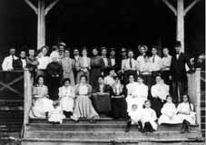 The reason for this gathering is unknown, but it includes several Beers descendants (and likely many who are not related) and was taken about 1905, probably at Olentangy Park. (Photos courtesy of Marty Cottrill)
Eliza Rathbone Wetmore, 1791-1853
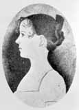 Eliza Rathbone Wetmore’s father, John Rathbone, acquired 4000 military land grant acres including all of Beechwold and much of Clintonville. John Rathbone gave Ohio a loan to build the Ohio canal and bequeathed 262 acres of land to his daughter Eliza. Eliza married Charles H. Wetmore, a physician, and the young couple settled in Clinton Township in 1819. Her land would eventually be purchased by the Columbus Zoological Company and would eventually become Old Beechwold. Some say that the stone pillars are the remains of the Wetmore driveway. (Courtesy of Columbus Metropolitan Libraries.)
A Lot of Bull
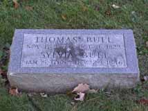 People like to say that the story of Clintonville starts with the story of Thomas Bull Jr., who came to this area in 1812 with his family from Vermont, by way of Worthington. Bull purchased about 680 acres in Clinton Township, and bequeathed land to his children when he died in 1823. Bull and his family were Methodists and abolitionists. The family graves were moved in March 1910 to Union Cemetery, section “new”, lot 176, across from the flagpole. (Despite the section name, this is in the old area of Union Cemetery on the east side of Olentangy River Road.)
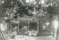
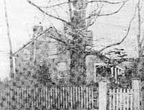 This is the Thomas Bull residence which stood on the east side of High Street between Dunedin and Piedmont. Some of the information about the house is conflicting, but Nancy Pendleton states that Alonson Bull helped to build the house around 1821 and lived there until the mid-1860s. The local Methodist congregation held services in this house until Thomas Bull’s death in 1823. Elias Pegg purchased it, along with its farm, in 1862 and raised his children there. The house was torn down in August 1931. This photo is from the Sunday edition of Cols Dispatch March 5, 1950.
Brevoort & Bull Graves
Thomas Bull’s daughter Chloe came to the area with her husband Isaac Brevoort and son Henry around 1812. Isaac Brevoort was helping build a barn across the Olentangy River and was crossing the flood-swollen river in February 1814 when his boat was swamped and he drowned. He was 23 years old, and was buried just 100 yards from the river. That grave is now someone’s back yard. Some say the grave is behind 247 Kenworth; some sources say it’s behind 253 Kenworth; some sources say that Isaac Brevoort is buried behind 253, and Thomas Bull Senior (father of Thomas Bull Junior) is behind either 247, or 253, or 257.
 Henry Brevoort’s house was built at 3620 North High Street, behind the original Brevoort cabin. The house continued to exist until around the 1970s, when it was torn down. The Brevoorts had an 80 acre farm; Developer Charles Johnson purchased the farm in 1909, and planned the Northmoor neighborhood carefully. He had the idea that vacant space induced people to build a nice house. Accordingly, he platted Northmoor Park and gave it to the city. He also did this with the bird sanctuary that today is known as “the Delta,” at the west end of Webster Park.
An early 1970s article stated that “stones still mark the [Brevoort] cabin” and that “once past the field stone gateposts [which were just wide enough for a carriage], the ancient barn where Frank Brevoort once operated a dairy still stands.” Does any of this still exist?
Post Office
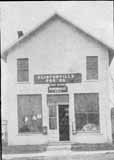 Clintonville was never platted as a formal village. Alanson Bull, the son of Thomas Bull, sold several small lots to tradesmen for their shops. Located at the northwest corner of High Street and Orchard Lane, a post office opened in 1847, in a two-story frame building on the northwest corner of High Street and Orchard Lane, and was given the name Clintonville because it was located at the center of Clinton Township. (This building has since been torn down.) The postmaster conducted a rag rug business upstairs. High Street at that time was a dirt and plank turnpike connecting Columbus with Worthington and Sandusky. In 1913 a new two-story brick building was erected on Dunedin at High. Mr. Legg operated a grocery store; Mrs. Legg sold notions. The post office moved there and remained until 1917—when, according to one source, RFD was offered, and according to another source, because the area was annexed by the city of Columbus. (I believe this second post office was a small building behind the corner building.) (Photo courtesy of the Clintonville Historical Society)
Underground Railroad
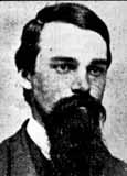
Alonson Bull and his brother Jason were abolitionists, Jason serving as a “conductor” on the Underground Railroad from Clinton Chapel at 3100 North High Street. Jason’s photograph is in the Wilbur H. Siebert Collection at the Ohio Historical Society.
Edward L. Sebring (1839?-1905) worked with Jason Bull to aid fugitive slaves escaping to freedom in Canada from Columbus, Franklin County, Ohio, to the next safe station. His photograph is in the Wilbur H. Siebert Collection of the Ohio Historical Society.
James G. Bull
 James G. Bull (1838-1927) was a grandson of Thomas Bull. James served as Columbus Mayor from 1865 to 1868 and from 1871 to 1875. His grandfather, Thomas Bull, was the first white settler of the area and James’ father, Alonson Bull, founded Clintonville in 1846. (Photo courtesy of Columbus Metropolitan Libraries)
Other early settlers…
include the Smiths, Websters, Coes, Whipps, Hunts, Wilsons, Bucks, and the Cookes. John Buck acquired land around Henderson and High early on, and then sold some of the land to Chauncey Cooke. Cooke in turn donated the land to the Clinton Township in 1842 to be used as a school.
Bishop Philander Chase
 … is credited with starting Kenyon College somewhere near North High Street and Selby Roads, in a house that has since been razed. An earlier home of Chase still stands at 62 Lincoln Avenue.
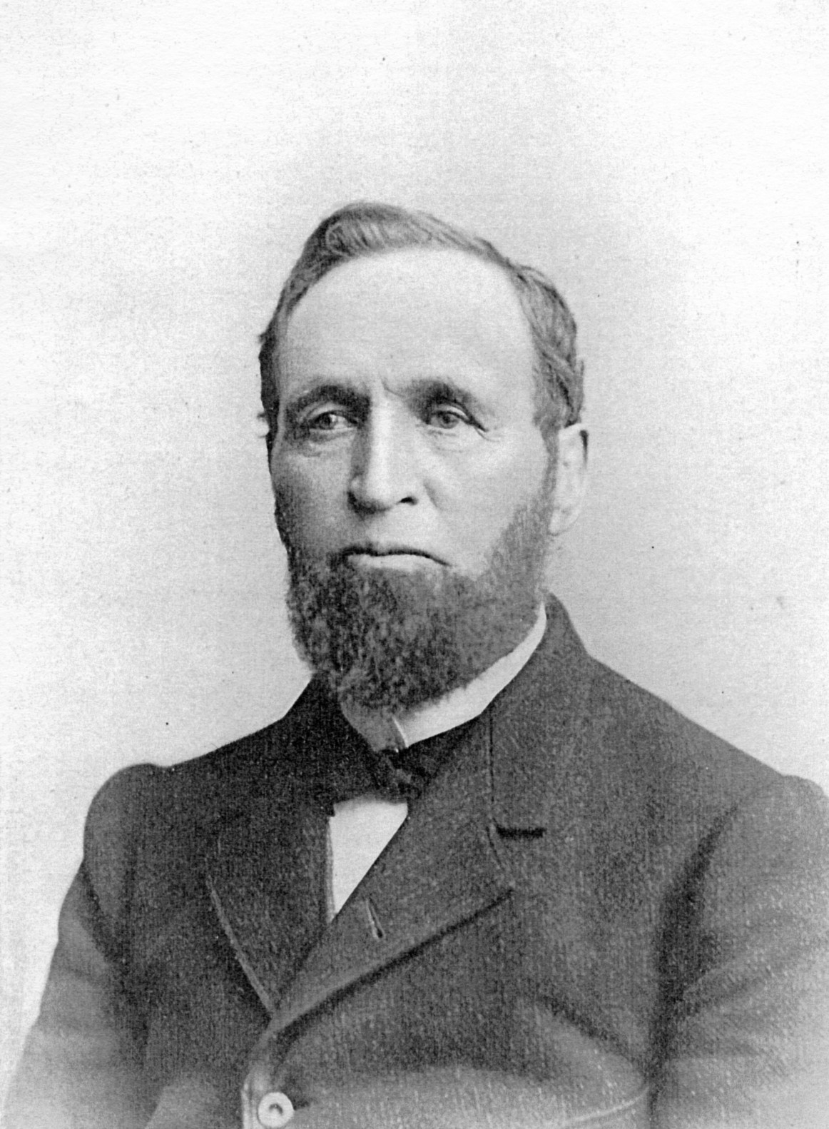
The Webers
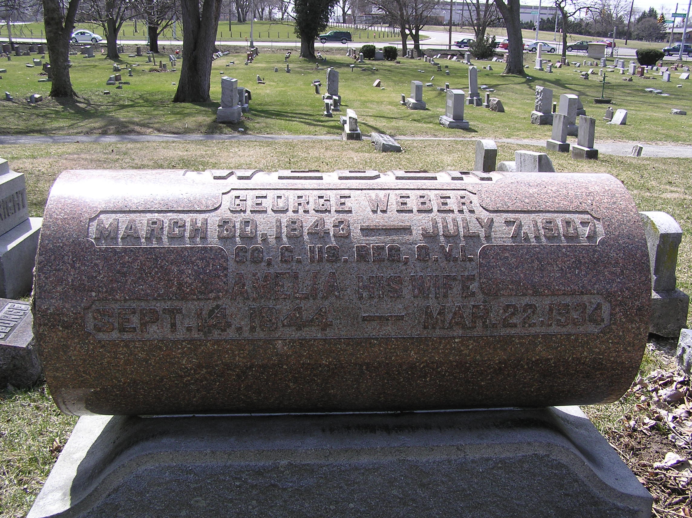 I found this little biography about Frederick Weber (1806-1885) and his son George (b. 1843) in A Centennial Biographical History of the City of Columbus and Franklin County Ohio (Chicago: The Lewis Publishing Company, 1901) pp. 278-280. I admit I have done little research on this Clinton Township family and have not even researched where their farm was located.
Barnabas Phinney (1813-1899)
 Barnabas Phinney (ca. 1813-1899) came to the area in 1838, and purchased 60 acres of land near the northwest corner of today’s Henderson Road and North High Street. In addition to farming, Phinney was an investor in the toll road running from Columbus to Worthington, and in the electric streetcar company. His house was said to be majestic. He and his wife had no children, and after his death most of the property was sold. A bit more biographical information can be found in A Centennial Biographical History of the City of Columbus and Franklin County Ohio (Chicago: The Lewis Publishing Company, 1901) p. 872 excerpted here. His obituary from the Columbus Dispatch January 30, 1899 is here.
Cooke family
 Another one of the first families of Clintonville was the Cooke family. According to the family’s history, Roswell Cooke (1764-1827) came to Ohio with his wife and five children in 1800 from Connecticut. His two eldest sons, Rodney and Chauncey, took up land 6 miles north of the state house, their farms adjoining (in the vicinity of Cooke Road and North High Street). They cleared the land and both erected “houses out of round, unhewn logs, with puncheon floors and primitive fire places, with mud-and-stick chimneys.” The brothers lived the rest of their lives on these farms. Family history states that in 1827 they constructed one of the first grist and saw mills on the Olentangy River, which later became known as the Whipp and then as the Weisheimer Mill. They also operated a distillery. (Photo courtesy of Terry Miller.)
 Rodney’s son, H.C. Cooke, was born in 1825, and took up residence on the old Cooke homestead at 4243 North High Street. Over time H.C. amassed 300 acres. He was a successful businessman, including in the stock business, and then owned the firm Cooke, Grant & Cooke, contractors in the construction of heavy masonry for railroad and other bridges. He was one of the officers of the Worthington & Columbus streetcar line. (You can click on this map to enlarge it.) (Photo courtesy of Carl Cooke.)
Just a bit more background information. The current name of the company Henry C. Cooke founded is the Fritz-Rumer-Cooke Co., Inc. They are still in business. The Secretary of State’s website states that one of their prior names was the Fritz Rumer Cooke Grant Company, changed to Fritz-Rumer-Cooke Co., Inc. in 1918. The company’s website states that it was founded in 1879 and incorporated in Ohio in 1911, and is still managed by descendants of the Cooke family. (This information courtesy of the Columbus Metropolitan Library.)
Rodney Romoaldo Cooke (1832-1866), brother of Henry C.
Roswell Cooke came to Ohio from Connecticut in 1800 with his wife and five children. The two oldest sons, Chauncey and Rodney, took up adjoining land in the vicinity of today’s Henderson Road and North High Street. Son Rodney (1793-1833) married Laura Cowles and together they had nine children: Esther (married to L. J. Weaver), Roswell (m. Lorinda Skeels), Helen (m. John Good), Rosalia (m. John Webster), Rachel (m. William Buck), Laura (m. Lester Roberts), Rodney Romoaldo (m. Chloe Williams), Demon, and Henry C. (m. Abigail Taylor).
Rodney’s son Rodney was a teacher and a farmer, and he served in the Civil War (Company G, 57th OVI). He was honorably discharged but returned from the war an invalid. Broken down in health, he was largely incapacitated for performing manual labor on his farm. He died in 1886, having been confined to his bed 11 years. A bit more biographical information can be found in A Centennial Biographical History of the City of Columbus and Franklin County Ohio (Chicago: The Lewis Publishing Company, 1901) pp. 248-252, excerpted here.
Never too many Cookes in the kitchen…
 Cooke family members married Buck, Armstrong, Hess, Maize, Webster, and Brown family members. The Cooke family held a series of family reunions from the late 1890s through the first decade of the 1910s, and maintained a log and minutes of their get-together. (Photo courtesy of Carl Cooke)
Armstrong family
 Another noted family in the vicinity of Henderson and High Street was the Armstrong family. Henry C. Cooke’s daughter Flora had married Llewellyn Armstrong. This is their house on the corner of Cooke Lane and High Street. A caption by Lulu Pearle Browne (Ohsner) also states “Clem Cooke [a son of Albert C. Cooke] born here—when first built Al and Lulu Cooke lived here.” (Photo courtesy of the Ron Ohsner family)
Alice Cooke

Alice Cooke Hess was the daughter of Henry C. Cooke, and worked for some years as a school teacher at the Clinton Heights Avenue School. She married Charles Hess, the great grandson of pioneer, Balser Hess. (The Hess family land formed Union Cemetery.) Alice and her husband eventually lived in the large house built by Henry Cooke at Deland and North High Street shown in my book and on this web site. This is her grave stone in Union Cemetery. (Photo courtesy of Terry W. Miller.)
Hess Barn
 Alice Cooke (daughter of Henry C. Cooke) married Charles Hess, a great grandson of Clinton Township pioneer Balser Hess. Alice had been a teacher at Clinton School. The Cooke-Hess house and farm were located just south of the corner of Henderson and High between Deland and West Cooke Roads on the west side of High Street, opposite the Ed Cooke home. The house was originally the home of Henry and Abigail Cooke. (Photo courtesy of the Ron Ohsner family)
 The bottom photo is a picture of the Hess family on their farm; Henry is supposedly in the middle. (Photo courtesy of Carl Cooke.)
Orlando Aldrich (b.1840)
 Orlando Aldrich was a prominent lawyer and OSU law professor. Aldrich was the first president of the Worthington, Clintonville & Columbus Street Railway Company and served in this position from 1891 to 1898; he subsequently held an office of the Columbus, Delaware, & Marion Electric Railway. Aldrich had purchased 23 acres of land on the southwest corner of Henderson and North High in 1882; it was a fruit farm called Maple Grove Farm. Aldrich had three great hobbies: horticulture, collecting great art, and collecting rare books about archaeology, and he engaged in these avocations from his lovely house located about where Maple Grove Church parking lot is located today. A bit more biographical information can be found in A Centennial Biographical History of the City of Columbus and Franklin County Ohio (Chicago: The Lewis Publishing Company, 1901) pp. 280-282, excerpted here.
Aldrich home
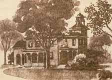 The land just south of Henderson and High was originally owned by Asa L. Parker, and was called Maple Grove Farm. Parker had purchased the land at sheriff’s sale in 1875 for $3,144. Judge Orlando W. Aldrich acquired the land from Parker in 1882, for the sum of $10,000. The old Aldrich home was charming, with a tower jutting two stories above the roof of the house. Judge Aldrich had used the tower as a study and a personal art gallery. From it one got a very good view of the Ohio State University buildings and the river valley. (Drawing by Bill Arter)
 The farm remained in the Aldrich family until 1923, when Charles F. Johnson purchased it and sold it in turn to Frank Sweigart. Sweigart remodeled the house, converted it into what has been variably called “Southern Colonial” or “Greek Revival”, and moved it so that it would face Aldrich Road instead of High Street. The house was later demolished to make way for a parking lot.
Maple Grove
 Here’s a picture of High Street looking north. Lulu Pearle Browne (Ohsner) and her dog are at the entrance to the driveway dividing the Browne and Al Cooke homes—presently the corner of West Cooke Road. The Aldrich house is on the left and Maple Grove church is in the center left. (Photo courtesy of the Ron Ohsner family)
“Civilized man cannot live without Cook[e]s” –Owen Meredith
 Ed Cooke was one of the sons of H. C. Cooke. This was the house of Ed Cooke; it was located on the east side of High Street where the Beechwold Theatre building—now the Columbus Sports Connection– now stands.
 This is a picture taken from Ed Cooke’s yard, looking northwest toward the Webster and Browne homes. According to the picture caption written by Lulu Pearle Browne (Ohsner), the fence at the right divided Ed Cooke’s “dooryard” and “barnyard;” and a hollowed stone watering trough stood under the big tree at the corner of the picket fence to water horses going and coming from the barnyard. The larger figure standing in High Street looking north is Al Cooke. The barn across High Street is the Hess barn. (Photos courtesy of the Ron Ohsner family)
Albert Clement Cooke
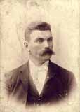 Albert Clement Cooke (shown here) was one of the sons of H. C. Cooke. To the right is a picture of Albert’s house.
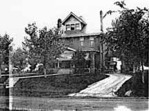
Albert’s land was in modern times rented for a Sandy’s restaurant, which later became a G.D. Ritzy’s ice cream parlor. Albert’s son was the first OSU athlete to participate in the Olympics; he ran in the 1912 Olympics in Stockholm. Albert’s grandsons Carl and Grant Cooke still live in central Ohio (Photos courtesy of Carl Cooke)
Treasure Map
 A handwritten map of the neighborhood, created by Lulu Pearle Browne (Ohsner), helps to clarify who lived where in the Maple Grove neighborhood in the early 1900s. You can click on this thumbnail and zoom in for a better view. (Photo courtesy of the Ron Ohsner family)
Cooke Cemetery
The Cooke family cemetery was located near the southeast corner of Cooke Road and High Street. According to genealogy records, the earliest headstone dated to 1817. Most of the graves were moved to Greenlawn or Union Cemeteries when Bishop Watterson High School was built in 1958. A few headstones were later discovered on a lot on Lenappe Drive. I would love to have some pictures of this cemetery.
There was also a John Rathbone Cemetery at the intersection of Morse and High.
George P. Whipp (b. 1817)
George Whipp came to the area with his wife and two sons from Maryland in 1833. His son George P. was 16 years at the time, and initially worked as a carpenter. Son George married Lucinda Smiley, and they had 10 children one of whom was also named George. The family farmed and had two truck stands along North High Street. (Note: Sometimes the family spells its name with one “p”.) A bit more biographical information can be found in A Centennial Biographical History of the City of Columbus and Franklin County Ohio (Chicago: The Lewis Publishing Company, 1901) p. 770 excerpted here.
Whip family
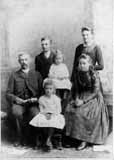 One of the oldest families in Clintonville is the Whipp Family (sometimes spelled Whip). They owned a farm, and a couple of stands along High Street that had big large orange signs advertising a refreshing drink consisting of freshly squeezed orange juice. The Whipps may have been the first owners of the mill located just north of Henderson Road and the Olentangy River. Here is a picture of the Whipp family circa 1889: George, Oscar, Everett, Laura, Cora, and Mabel. (Photo courtesy of Sue Gallogly)
The Whips lived at 73 East Weisheimer.
Schreyer house
How I would love to acquire a picture of the old Schreyer House. This was described as being one of the first high-class homes in its neighborhood. The property was 50 acres, from High Street to the Olentangy River, bounded by Henderson to the south and the “Stewart and Weisheimer farms to the north.” The grand house was built by Barney Phinney (one of the owners of the Worthington Pike) about 1893, and was subsequently sold to G. Schreyer, a Columbus stove and furnace manufacturer.
Two excellent orchards grew on the place. A windbrake of splendid walnut trees protected one orchard and a row of fine maples formed the windbrake for the other. There was also a very good spring just west of what is now Rosemary Parkway. Surrounded by rose gardens and shrubbery, the house was an imposing structure with pointed gables and the interior finished throughout with solid walnut.
Mr. Schreyer died in 1901, and his wife (Ernestine Zeller, after whom Zeller Road was named) moved elsewhere. The old Schreyer house was eventually subdivided into apartments. The house burned down in 1913; the Columbus Fire Department had been called but could not respond, because there were no water lines in that vicinity at the time. The land was purchased by Charles Johnson in 1923 and subdivided into the Rosemary Development.
And as a side note: “Rosemary” was the name of Charles Johnson’s mother.
Train Wreck
 This is a train wreck that occurred in 1880 north of Hudson, at the Big Four Railroad tracks. (Photo courtesy of Judy Cohen)
Dodridge Bridge
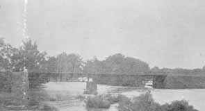 As my book shows, there was once a covered bridge over the Olentangy River at Dodridge Road. The Dodridge covered bridge was replaced by a truss bridge built by the Columbus Bridge Company. This picture shows the replacement bridge in 1890. Fishing from the bridge was a favorite activity for many 20th century Clintonville residents. It was a lovely river, and crappy and small mouth bass abounded. (Photo courtesy of Columbus Metropolitan Libraries)
Full of Glee
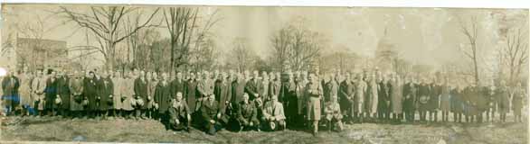 I love the story of the Republican Glee Club. Here it is: It was 1872, shortly after the nomination of Ulysses S. Grant for his second term of President. Some men were enjoying a convivial evening in one of the rear rooms of the Old Ambos Restaurant and Café on South High Street, and discovered that they all liked to sing and all were Republicans. Henry W. Frillman, one of the group, had just returned from Chicago and reported on the activities of a political glee club he heard sing there. The men decided to start a Republican singing and marching club, and called themselves the Grant and Wilson Glee Club. They rehearsed rigorously and became much in demand at rallies around the state. They were even invited to take part in the inaugural festivities in D.C. After the election, the group disbanded but in 1876 reconvened as the Hayes and Wheeler Glee Club. Members participated in four successive campaigns, and participated in state and local campaigns as well. In 1895 they incorporated as “The Republican Glee Club of Columbus Ohio.”
In the late-1920s, they moved their headquarters to 57 Weber Road and remained there until about 2000. The building is now a private residence. (Photo courtesy of Tom Atzberger)
Broadway House No. 1
 North Broadway was developed by the Loren and Dennison company in 1897; it was intended to be the place to live, and it was. James Loren originally planned to call it the Oakland Addition, but the post office requested he change the name to avoid confusion with another neighborhood. It had a small railroad depot and post office at North Broadway’s east end at the Big Four Railroad track. This house at 510 North Broadway Street was the first house built in the subdivision. It was built around 1890. It was sometimes called Acton Place, for reasons I was unable to discover. By 1894 it was owned by a man named E. Howard Gilkey. The William W. Daniel family purchased it in 1896, and the house remained in that family’s hands until 1961. It burned down in 1966. My Clintonville and Beechwold book has a photograph of the original house; this photograph shows the fire. The spot is now occupied by Columbus Speech and Hearing Center. (Photo from an unnamed newspaper clipping)
The Loren House
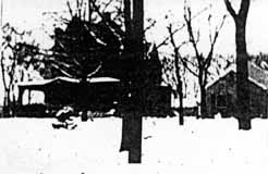 I also found a handwritten history that said that this was the first house built on North Broadway and was lived in, or owned by, someone named Loren. I do not recognize the house—do you? (This very poor image was taken from a photocopy of a microfilm.)
According to the 1896-97 city directory, there was also a Jeremiah C. Loren (motorman) living 1 building north of North Broadway on the east side of North High Street.
Mary Rodgers (resident of East North Broadway who has been researching the houses along East North Broadway) believes this is a picture of 625 East North Broadway, a house which was in the Broadway Villa subdivision and which I have written about here. It was lived in by the MacIntosh family.
Broadway House No. 2
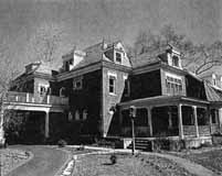 East North Broadway was developed by the Loren and Dennison company in 1897; it was designed to be a posh neighborhood, each house on a 1-acre plot of land. It had a small railroad depot and post office at North Broadway’s east end at the Big Four Railroad track. This house at 242 North Broadway Avenue was the second house built in the subdivision. (From Business First magazine)
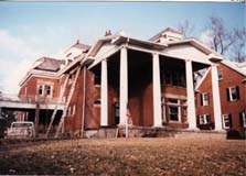 242 East North Broadway was renovated beautifully by owner Gary Means. The care with which he selected materials and kept true to the house’s original design takes my breath away. The house has not always been so lovely. For several years–prior to the present owner–this (to the right) is what it looked like.
On Broadway (…on Broadway)
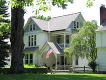 My book, Clintonville and Beechwold, page 19, shows an image of East North Broadway, looking east toward Indianola Avenue in the late 1800s The large house to the right of the photograph (south side of North Broadway) still exists at 489 East North Broadway (top photo).
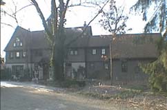
The building just to the left of 489 in the photograph still exists as well, as a private residence; it was originally the carriage house of the large house on the south side of North Broadway in the distance (bottom photo). That large house was formerly 625 East North Broadway in the Broadway Villa subdivision.
Evanston Post Office and Depot
In my Clintonville & Beechwold book, I mentioned that there was a post office at the eastern end of North Broadway where it crossed the railroad tracks. It stood on the east side of the tracks near what is now Oakland Park Avenue. The “Evanston” post office was opened on May 22, 1893 and ran until November 23, 1893. The name was changed to North Broadway Post Office around July 6, 1894 and remained open until about September 1902.
The Evanston depot, shown in my book, was located where East North Broadway met the railroad tracks. The depot finally burned down but trains continued to stop upon signal for many years more. There is on old maps a short arc of a street there, called Depot Park Road.
A 1910 map reveals that a man named Charles F. Evans owned the property where the North Broadway depot and post office likely were located, so I assume this is how they got their names.
East North Broadway
According to a 1999 Booster article by Anne Barry, in 1923, East North Broadway was the only paved street north of Fifth Avenue. It was paved with Hallwood Block, and the sidewalks were paved with brick as well. Old maps show a traffic circle at the intersection of East North Broadway and Beech Hill Avenue/Calumet Street, which appears to have been put there for aesthetic reasons. I believe half of this circle remained as late as 1985.
Raison d’être for Broadway
According to a transcript of a WBNS-Radio broadcast salute to Clintonville on May 27, 1959 and reprinted in The Clintonville Historical Society’s January 2009 issue of its newsletter, Clintonville Heritage, Olentangy Park and East North Broadway’s development are linked. The street was supposedly laid out because of the Olentangy Park Theatre:
And one of the grandest streets was laid out because of the Olentangy Park Theatre–it was North Broadway, North Broadway was a lovely, tree-shaded, paved boulevard, when all around was nothing but dusty country roads. There lived famous actors from Broadway like Elsie Janis and Vaughn Blaise…
St. James in the Woods
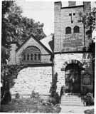 All the literature for St. James Episcopal Church states that it was organized in 1881, and that church members met in local schools before they had their own church building. I admit to being skeptical of that date and believe 1891—when James Loren began developing East North Broadway and donated a lot on Beech Hill Avenue (now called Calumet Street) for the church–is nearer to the mark. Some sundry facts about this, the oldest continually running Clintonville church:
• The original exterior was a Tudor Revival Style. The cornerstone was laid in 1894, and the mission was consecrated in 1896.
• The church was enlarged to a seating capacity of 200 in 1927; that was also when the church building got indoor toilets.
• The original church was traditionally covered with ivy. The ivy growing on the church grew from a shoot brought from Kenyon College in Gambier, Ohio, which in turn got its ivy from somewhere in “old England.”
(Photo courtesy of St. James Episcopal Church)
Who were Loren and Dennison?
 James M. Loren (b. 11/30/1849, d. 2/13/1931) was an attorney who loved real estate. He lived at the corner of King Avenue and North High Street (1371 North High Street) from the time of his marriage to Miss Annabel McMillen in 1878, until his death. He was closely identified with the family of former Ohio governor William Dennison, and handled their real estate affairs; he shared a suite of offices with William’s son Herman G. Dennison. Loren laid out, platted, and sold not only East North Broadway but also Dennison Place, Dennison Park, Dennison Summit, and a few other subdivision in northern Columbus and Worthington. Loren’s daughter married Joseph Walter Jeffrey. James Loren’s mausoleum is in Greenlawn Cemetery, lot 41, section 56. For more information you can read his obituary from the Columbus Dispatch Feb 13, 1936, p. 6A, and his biography from Osman Hooper’s 1920 book, History of the City of Columbus, Ohio, pp 453-454.
Herman G Dennison died in 1912 at age 59 in an automobile accident. More information here.
This information came to me courtesy of staff at the Genealogy, History, and Travel Department of the Columbus Metropolitan Library System.
Looking West from 3134 North High St, 1896
 This photograph was labeled, “Looking west from 3134 N. High, 1896”. It’s an exciting glimpse of how Clintonville used to look. (Photo courtesy of the Dawson family.)
Beechwalde Cont’d #2
Compare these two images of this wooden structure located somewhere on Beechwold property as the property was being subdivided into a housing development. You can click on the thumbnails to see them in a larger format.
 The first photograph shows tire tracks driving right up to the opening between the two sections of the structure. In that photo there are window panes in the windows, and the structure is surrounded by brush and foliage.
 In the second photo, the windows and the foliage are gone. A different photo of the structure during this era is found in my book, Clintonville and Beechwold.
I have been unable to find anyone who remembers the structure first-hand. (The first photo is courtesy of Karen Sweigart Longava; the second photo courtesy of Amy Westervelt.)
Beechwalde Cont’d #3
Compare this watercolor from the promotional brochure for Beechwold, Beechwold the Beautiful, to the image found in my book, Clintonville and Beechwold, on page 26. (Image courtesy of Karen Sweigart Longava.)

Toll House
The Worthington Pike, now called High Street, was supported by funds collected from a toll gate which was located opposite from Olentangy Park. The gate was operated by the Applican family, parents of Mrs. N. E. McCoy. The pole was let down each night and not opened until 4:00 a.m. Dr. Albert Cooper was the North Columbus physician at that time. If he had gone north on a call. the toll keeper always waited up for him or else was roused from his sleep in the night to raise the pole and let the doctor pass through on his homeward trip. –from an old undated newspaper clipping
North Congregational Church
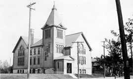 This church is not in Clintonville, but because it is so close to Clintonville I could not resist including North Congregational Church located at East Blake and East Avenues, on this website. The photograph was taken in 1900. (Photo courtesy of Judy Cohen)
Never Too Many Cookes…(the article)
I wrote this article for the Clintonville Historical Society newsletter and am reproducing it here for your convenience…
Never Too Many Cookes…
by Shirley Hyatt
© Shirley Hyatt
We often think of Clintonville as having been established in 1847 near the intersection of Orchard Lane and North High Street on Bull family land, but we mustn’t forget that today’s Clintonville extends north to Worthington, and that other families contributed significantly to the development of Clintonville’s northern reaches.
One of the most vibrant little communities was centered near the intersection of today’s Henderson Road and North High Street (or more precisely, Cooke Road and North High Street). In streetcar days this was known as Cooke’s Corners, because it was established by the extended Cooke family.
Roswell Cooke came to Ohio from Connecticut in 1800 with his wife and five children. The two oldest sons, Chauncey and Rodney, took up adjoining land in the vicinity of today’s Henderson Road and North High Street. At the time the land was densely wooded, and the Cookes had to clear the land to establish their farms. By 1827 they operated large productive farms, had built grist and saw mills along the Olentangy River (near Weisheimer Road), and also operated a distillery.
Roswell died in 1827 at the age of 63. Son Rodney (1793-1833), a veteran of the War of 1812, married Laura Cowles and together they had nine children: Esther (married to L. J. Weaver), Roswell (m. Lorinda Skeels), Helen (m. John Good), Rosalia (m. John Webster), Rachel (m. William Buck), Laura (m. Lester Roberts), Rodney Romoaldo (m. Chloe Williams), Demon, and Henry C. (m. Abigail Taylor). Sadly, Rodney died when his youngest child was just 3 months old; wife Laura supported the family by working as a tailor. She herself lived until she was 73 years old.

Genealogies state that Henry C. was born “near Olentangy Park in 1825.” After his marriage to Abigail in 1852, he moved back to the old Cooke family homestead and gradually purchased property from the other Cooke heirs. Eventually he consolidated 300 acres of good productive farmland. Henry and Abigail had seven children: Clara (married to Wellington Webster of Findlay OH), Flora (m. J. L. Armstrong), Albert Clement (m. Lulu Brown), Edwin (m. Ella Haines), Mary (m. David Maize), Alice (m. Charles Hess), and Harry Lester.
Henry C. Cooke worked for awhile as a teacher, then as a farmer. He also went into the stock business (i.e. shipping stock). In 1879 he went into business with A. G. Grant to form Cooke, Grant, and Cooke, which constructed heavy masonry bridges. (This company’s projects may include the present Henderson Road bridge and a few others in the area.) Henry was one of the promoters of the Worthington and Columbus streetcar line. He was prosperous, and built a magnificent house along present-day North High Street at Deland Avenue. (You can see its photo in my book.)

I named the spouses of Henry’s children above to show how tightly knit the community was. The Webster’s family farm was south of the Cookes’ along today’s North High Street. The Armstrongs, the Maizes, and the Bucks, and Albert Clement Cooke, all lived a very short distance from Henry. Daughter Alice—a schoolteacher at the Clinton Heights school—had married one of the great-grandsons of Balser Hess and they lived in Henry’s grand home.
John Buck was one of the early pioneers who received a military land grant in the area; some records state that he sold the original Cookes their land. Descendents of John Buck had a market on North High Street; long-time residents still remember Buck’s market today, and short-time residents may still recall the Buck residence, an Italianate-style house just north of the northeast corner of Henderson and North High. The Bucks were related to the Cookes by marriage.
George Whipp came to the area with his wife and two sons from Maryland in 1833. Whipp had received 160 acres of land in return for military service, and he also purchased the mill property that had been built by the Cookes. (At some point in time the old mill on the river was called “Whipps Mill” and Henderson Road bridge was known as “Whipps Bridge.”) His son George (b. 1817) was initially a carpenter, and was credited with building many of the houses of Clinton Township. Son George married a neighbor named Lucinda Smiley in 1838, and they had 10 children (one of whom was also named George). The family farmed, and though much of the acreage was eventually sold off, the Whipp family continued to own a truck farm in the area. Old timers can still recall the big orange sign for Whipp’s Orange Mill, a fruit stand located at 4588 North High Street featuring fresh squeezed orange or pineapple juice. The Whipps were related by marriage to the Bucks. (Note: sometimes the family spells its name with one “p”.)
An article about this tightly-knit community warrants mention of two other families, the Aldrich family and the Phinney family. Orlando Aldrich (b. 1840) was a prominent judge, lawyer and OSU law professor. Aldrich was the first president of the Worthington, Clintonville & Columbus Street Railway Company and served in this position from 1891 to 1898; he subsequently held an office of the Columbus, Delaware, & Marion Electric Railway. Aldrich had purchased 23 acres of land on the southwest corner of Henderson and North High in 1882; it was a fruit farm called Maple Grove Farm. Aldrich had three great hobbies: horticulture, collecting great art, and collecting rare books about archaeology. He engaged in these avocations from his lovely house located about where Maple Grove Church parking lot is located today. According to artist and local historian Bill Arter, Aldrich had a magnificent view of the river and OSU campus from the turret of his house. This house was moved slightly, rotated, and completely revamped in the 1920s by subsequent resident Frank Sweigart. (For more information, see my web site, www.clintonvillehistory.com.) It’s from this farm that the area around Henderson Road and North High Street and the church get their names today.
Barnabas Phinney (ca. 1813-1899) came to the area in 1838, and purchased 60 acres of land near the northwest corner of today’s Henderson Road and North High Street. In addition to farming, Phinney was an investor in the toll road running from Columbus to Worthington, and in the electric streetcar company. He married Mary Smiley and was probably brother-in-law to George Whip. Their house was said to be majestic. They had no children, and after his death most of the property was sold. At some point (circa 1893) the house was sold to the Schreyer family, and then chopped into apartments. I would love to see a picture of this grand old home. In 1913 a fire broke out; the city fire department was called but there were no water lines that far from the city, and so the building burned to the ground. (Luckily, no one died in the blaze.)

By the early 1900s, this was a tight and thriving community. The houses were handsome. The Cooke family held annual reunions at the Cooke house—old photos show the family eating at long tables arranged in the shape of a “C,” and they kept an ongoing register with names of attendees and minutes. The community held plays to entertain each other, went sledding on today’s North High Street, went horseback riding along Indian Springs Drive, worked and had fun, and worshipped.
The original Cookes were said to be Universalists, but somewhere along the way most of them became Methodists. In 1842 Chauncey Cooke had leased a 32-foot by 99-foot portion of his land on the corner of Henderson and North High to the Clinton Township School district to be used for both education and religious purposes. A school house was built in 1878, and it was used by the Clinton Township School District as well as by local Christian worshippers. When Orlando Aldrich purchased his beloved Maple Grove fruit farm, his tract surrounded the school and church property, and Aldrich expanded the land dedicated for school and church purposes to three-quarters of an acre. In 1919, when the school district had ceased using the building for educational purposes, ownership of the building and land reverted to the Cookes. Family members agreed to sign quit claims, and the property was put into the hands of the Como Avenue Methodist Church until a neighborhood church could be formalized. In 1920 Maple Grove Methodist Episcopal Church officially organized and assumed ownership of the church they had probably long worshipped in.
The Cooke family had a family cemetery located on the southeast corner of Cooke and High. When Bishop Watterson High School was built in 1958, the graves were disinterred and moved to Union or Greenlawn Cemeteries.
Luckily the activities of the neighborhood were documented by Lulu Brown Ohsner–a Cooke family member, neighborhood resident and parishioner of Maple Grove Church who has since passed away—in some presentations to Maple Grove Church about 15 years ago. And, many Cooke and Whipp family members still live in the Columbus area, and have family photos and memorabilia. Henry C. Cooke’s contracting company Cooke, Grant, Cooke is still in existence; the current name of this company is the Fritz-Rumer-Cooke Co., Inc. It incorporated in Ohio in 1911, and still specializes in railroads and other general contracting. Sadly, most (though not all!) of the lovely homes owned by the Cooke family members have been torn down.
Clinton Heights Avenue Trivia
 I recently had the benefit of reading an abstract from one of the north-side-of-Clinton-Heights-Avenue residents.
A couple interesting things from the abstract:
Calumet Street, according to the abstract, used to be called “Oak Hill” before the name was changed to “Beech Hill,” and then changed to “Calumet.”
The alley along the north side of Clinton Heights traversed through the school property and then to North Broadway. I have often wondered about this vacated alley, which runs behind the properties along the north side of Clinton Heights Avenue and the south side of East North Broadway. It’s a recessed, ravine-like greenspace that doubtless has many city services running along its banks. You can see this alley in the 1910 and 1920 maps on my web site. The rumor passed to me by former Clinton Heights neighbors was that the North Broadway residents had petitioned the city to vacate this alley, but when the city approved the request, they gave the alley property to the residents of Clinton Heights Avenue instead of splitting it between the residents of the two streets.
The abstract gave me specifics of the vacating. By ordinance No. 38053 duly passed by the Council of the City of Columbus, Ohio, on May 2, 1927, the first alley north of Clinton Heights Avenue “from Beech Hill Avenue to the west line of lot 68,” 12 feet, wide, was vacated. (No indication in City Council minutes of who actually submitted the petition, and I have not bothered to look.) The City Council minutes are attached <here>.
More about the land that became Clinton Heights Avenue…
Henry Cooke once owned part of the property that was later developed into the Clinton Land Company addition.
I have often read an old anecdote that James Chesnut (sometimes spelled “Chestnut”), who owned the house on Wall Street, had blocked the improvement of North High Street along his property near Brighton and North High Street, because a beloved locust tree would be damaged or removed by the paving. The abstract bore some of this out. In the abstract (relevant pages linked here), the property developers were assessed $5400 for improvements in the Worthington and Columbus Plank Road, but, they said, these improvements were never made, because James Chesnut (and others) “were defendants procuring an injunction perpetually enjoining the making of said improvements along his premises.” The Clinton Land Company owners sued, or perhaps countersued, stating that they had been assessed conditional on improvement of North High Street, which improvements had not been made. Who won: You can read the attached excerpts of the abstract and decide for yourself.
3070 N High Street

Here is an amazing photograph of High Street, given to me by Stu Koblentz, who found this image in an old student thesis by Forest Ira Blanchard. The photo looks north, taken around 3070 North High. On the right (east) side of High Street I believe is the house of Mathias Armbruster, which later became the Southwick Good Fortkamp Funeral Chapel at 3100 North High Street at Weber and High. I’m told that some gravestones from the old burial ground are visible on the right. Check my book, Clintonville and Beechwold, for a better photo of this house. You can click on the image to see it in more detail.
[Citation: Blanchard, Forest Ira. 1922. An introduction to the economic and social geography of Columbus, Ohio. Thesis (M.A.)–Ohio State University, 1922. On January 16, I replaced the grainy version of this image on this web site with a higher quality photo after Joe Smith alerted me to its existence.]Chesnut House

And another amazing old photo of North High Street from Stu Koblentz. This photo also looks north, and was taken just south of the intersection of High and North Broadway. The house on the west (left) behind the little shack (marked “ice”) is the Chesnut house (aka Chestnut house), described in this web site’s “Water for Cookies” entry and also found in my book. The school on the east (right) side of High Street is the old Clinton Township school building, a picture of which is also in my book. You can click on the image to see it in more detail.
Stu’s theory about the Chesnut house is as follows:
The image shows the Chesnut house, facing North High Street, about where it currently stands. The facade that faces Wall Street today is the facade facing High Street. This is verifiable in the chimney placements.
So I went through Joe Testa’s web site and I think I know what happened to the house.
As far as I can tell the house stood approximately at 3327-29 North High Street. In the 1910s, when the house (which appears to have been built in the 1860s or 70s) is pictured, the house had been moved on a pivot to its current location, with its northeast corner remaining close to its original placement. This would account for the front lot build out, the twist in the alley and the sudden reemergence of Wall Street as well as the placement of the house in the picture, and the current location of the house.
What is interesting to me is why did they go to all that trouble, when its fairly common in urban settings to build a street facade onto a house and call it a commercial building. I think that part of the reason is that the house sat further back from High Street, making it too far away to convert to a commercial space commonly found in that era.
Update 2025-08-25 by Shirley–Another possible reason for reorienting this house might be found here.
Water for cookies
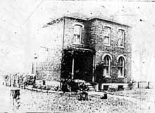 The township school located at Clinton Heights Avenue and North High Street did not, originally, have running water. Every day a child was designated to carry one bucket and dipper across High Street to the Chesnut house (see page 12 in my book, Clintonville and Beechwold) to fetch water that would be shared by the students. Legend has it that there were no lack of volunteers for water duty, as Mrs. Chesnut (or perhaps it was her daughter Fannie) always had cookies for the volunteer. This is a bad, yet significantly older, image of the Chesnut house.
Almost another Calvary Church…
As early as 1819, Methodists in Clintonville worshipped in people’s homes—the home of Eber Wilson has been mentioned– with circuit riders as preachers. Methodism was, in those days, a young and evangelical sect. When Thomas Bull, one of Clintonville’s early settlers, died in 1823, he left land in his will to build a church for the members, and that church was erected 15 years later at 3100 North High Street near Walhalla Road & High Street. Southwick Good Fortkamp Funeral Chapel occupies that building today.
The church membership decided in 1881 to sell the chapel and move the church to the thriving community of North Columbus, and they built a new church on East Tompkins. Several members dissented from this decision and, under the leadership of Eli Batterson, met at homes and at the Clinton School. In 1905 Howard Westervelt—great-grandson of Thomas Bull—reorganized a Methodist Sunday School, and church members worshipped in the home of Frank Dankworth at 70 West Lakeview. They founded Como Avenue Methodist Church in 1910. By 1924 they had outgrown that church and decided to build a new church edifice at North Broadway Avenue and Broadway Court. There were three candidates for the new church’s name: St. Paul, Calvary, and North Broadway; North Broadway was chosen.
The play’s the thing


In 1925, members of Maple Grove Church presented a play at the church. The play was Friendly Helpers Class. It was a success and was taken on the road to the Linworth and King Avenue Methodist Churches. The left photo shows cast members Katherine Cooke (Barbee) and Lulu Browne (Ohsner), Dorothy Cooke (Hambleton) and a neighbor playacting for the camera in 1925. The photo on the right is the program for the June production. (Photo courtesy of the Ron Ohsner Family)
Gordon Brevoort’s Chickentown
 Several years back, Gordon Brevoort gave a wonderful presentation to the Clintonville Historical Society about he and his family’s life in Clintonville. The Brevoorts are one of Clintonville’s oldest families, and some still live in the neighborhood.
Gordon told the listeners about Chicktown, the fantasy land he and his friends played in.

The old Brevoort homestead has been torn down but I liked the old image of it. (There is a picture of it on page 12 of my book). More from or about the Brevoorts here.
(Documents and photo courtesy of Gordon Brevoort)
East Como
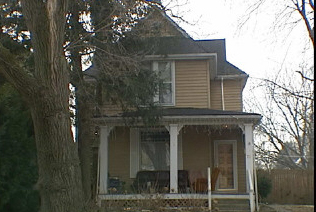 Perhaps the first house to be built on East Como was this house at 71 East Como. The owner from 1908-1926 said he recalled a little brook that ran near the house and a footbridge leading to High Street.
Log House
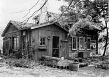 This diminutive log structure was built in Meigs County in 1840 and brought to Clintonville in 1937 by Grace McGrath, great-granddaughter of the original owner. The house was put next to McGrath’s home. McGrath was an art teacher at Central High School and she used it as an art studio. Subsequent owners have expanded the house with bathrooms, an updated kitchen and bedroom, and porch. (Photo by Inga Smith, photo displayed courtesy of the homeowner)
Log houses, log cabins
Don Hutslar, in his book Log Construction in the Ohio Country 1750–1850, differentiates between log cabins, which were intended to be temporary, and log houses, which were intended to serve as a home and were consequently sturdier, larger, perhaps taller. I wonder how many log homes there are in Clintonville, covered by contemporary siding. I have been told that there is one at 232 West North Broadway, on the north side of West North Broadway, east of the river.
Maple Grove Church
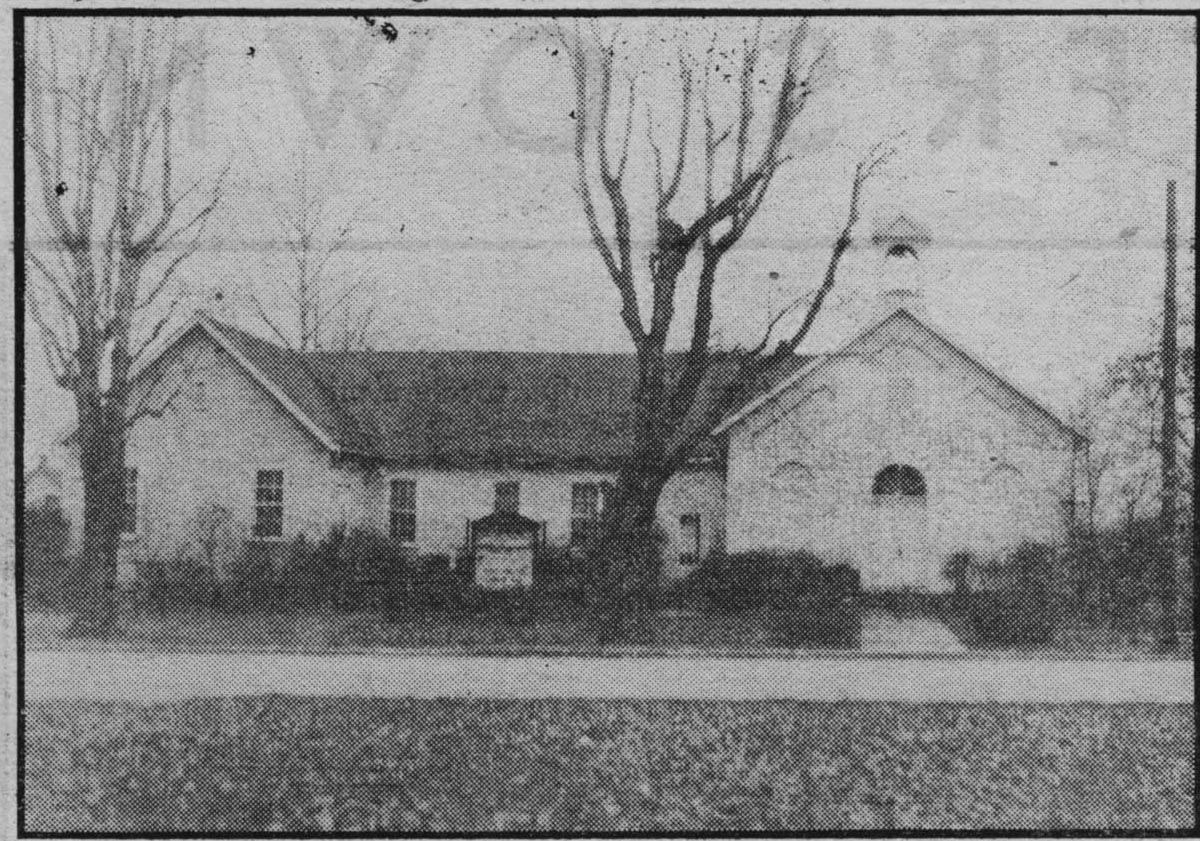 Maple Grove Church in 1939. Originally owned by John Buck, by 1842 the property on the southwest corner of today’s Henderson Road and North High Street was owned by Chauncey Cooke. Chauncey leased the lot to the directors of Clinton Township School District No 1, and the lease contained the clause “to have and to hold said demised premises as long as they shall be used for school purposes.” A clause was also added “that the lot and building to be erected thereon shall be used for Public Worship by any Christian denomination for the accommodation of the neighborhood.” Lore has it that the lease was not recorded but was held by the Clinton township clerk for a number of years, and the late Mr. L. L. Pegg found it in the corn crib of the township clerk in the year 1919.
Weisheimer Mill
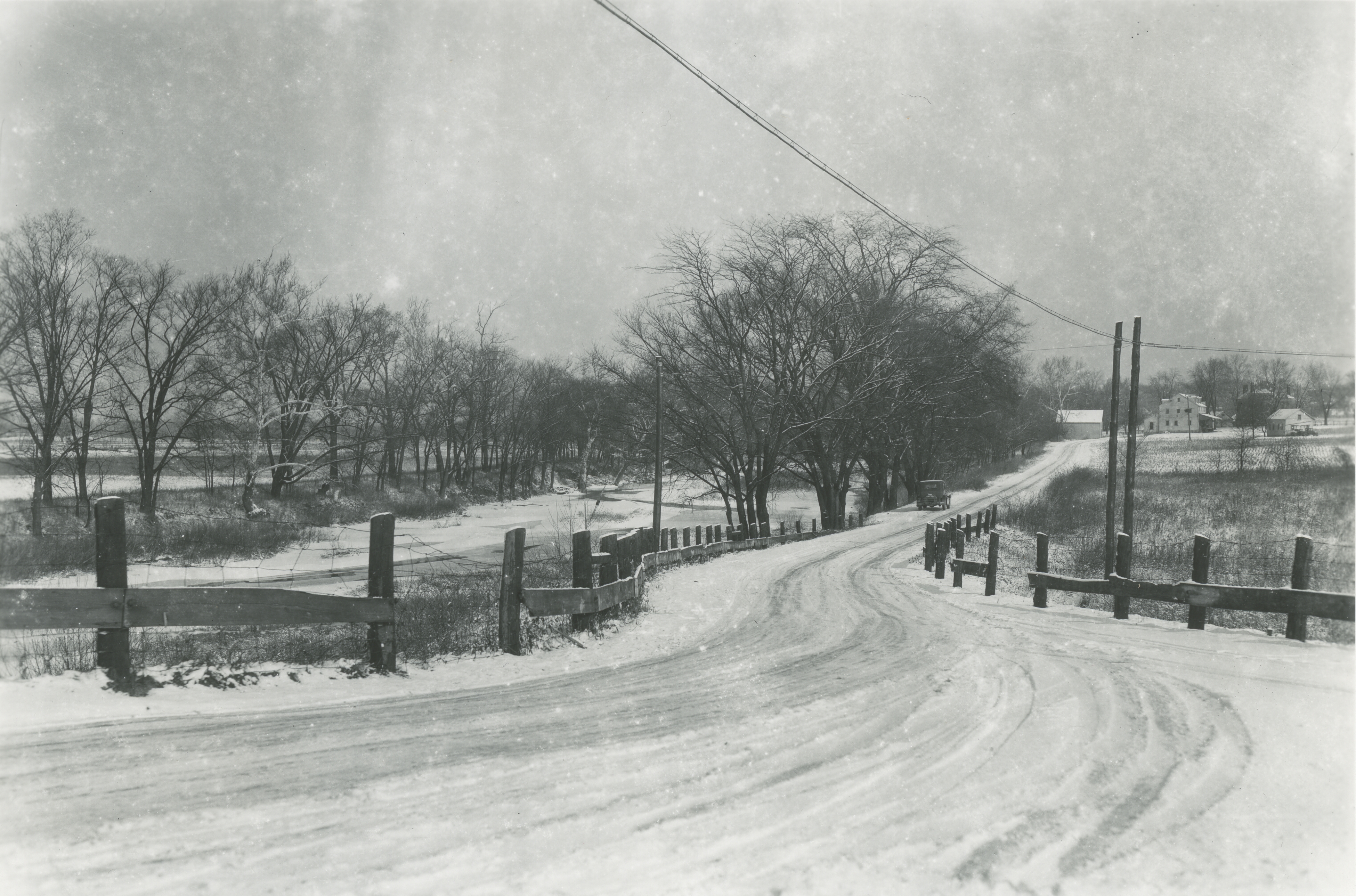 A wonderful picture of the Weisheimer Mill including the Jacob Weisheimer home (which still exists) and other buildings at the mill complex. The photographer would be looking north up Starrett Road to Weisheimer Road. You can click on this image to see the distant details. I show some other images of the mill and Weisheimer homes on pages 21-22 of my book. (Photo courtesy of the Columbus Metropolitan Library.)