Home
Mayor George Sidney Marshall
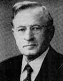 One of Clintonville’s notables was George Sidney Marshall (869-1956). He was raised on a farm in Perry County and attended Ohio State University. He graduated from OSU in 1894 and then from its law school in 1897. He was active in local politics, and became mayor in 1910 on the Republican ticket. After his term of mayor, he returned to the practice of Law and retired in 1946. He and his wife had a longstanding interest in music, and formed the Clintonville Music Study Club. In his retirement (and after the death of his wife), Marshall wrote a history of music in Columbus, a thorough account of all the local nonprofit musical organizations across the city. His book, called The History of Music in Columbus, Ohio, covers the period from February 14, 1812 to July 1, 1953 and was published by the Franklin County Genealogical Society.
George Sidney Marshall’s son, George B. Marshall, was also an attorney and served as a Franklin County Common Pleas Court Judge for 26 years. He retired in 1980 and died in 1981.
Kerchner Garage
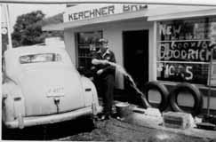 In 1948, the garage on the northeast corner of Glenmont and High that had been used as a World War II Civilian Defense Center was purchased by Joseph Kerchner. His brother George soon joined him. The brothers ran the Sohio Kerchner Brothers garage and filling station from until 1950. (Photo courtesy of the Kerchner family)
Our Lady of Peace Church
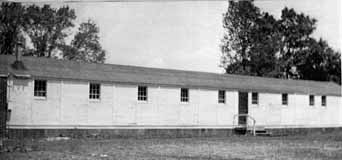
Our Lady of Peace is another church that met in the Beechwold Theatre before their building was erected.
The new parish was decreed on January 17, 1946. In the earliest days, weekday masses were said in the apartment of the new pastor, Father George H. Foley. Sunday mass was held in the Beechwold Theatre and later, at the A.A. Schroyer funeral home (now Weir Arendt). The church purchased land on the northeast corner of Dominion Boulevard and N. High Street, which at the time contained two buildings: an old farm house that was torn down, and a second building that served as a rectory and convent. The first church consisted of a barracks (side view of which is shown above) obtained from the Army Supply Depot at Marion. Prisoners of War constructed the kneelers. A double barracks was used for the first school, which opened September 3, 1947. An old mobile voting booth was used by the nuns as a kitchenette.
It’s customary for Catholic churches to build a permanent school first, followed by the church. Cornerstone rites were held in 1951 and the school opened in 1952. The present church was built in the late 1960s. (Photo from Our Lady of Peace dedication brochure)
Our Lady of Peace School
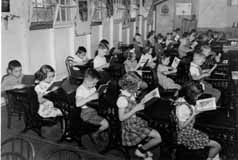 These children are a little stiff, and obviously no one told them to “say cheese”. But the children are cute and some of my readers may be in this photo. These are Our Lady of Peace students in the late 1940s, taken by photographer Ken Hauer. (Photo courtesy of Marge Hauer)
Lustron Houses
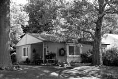 Between 1948 and 1950, the Columbus-based Lustron Company made 2,500 all-steel, prefabricated houses and shipped them nationwide. Unlike the more traditional architecture of Sears homes, Lustron houses offered a sleek, modern aesthetic. They were easy to maintain, and affordable. Despite a backlog of orders, the company went bankrupt in 1950. There are 4 porcelain-steel Lustron homes in Clintonville; this one is located at 272 East Weisheimer. (Photo courtesy of Lynn McNish)
Fuller Farm & Whetstone Park
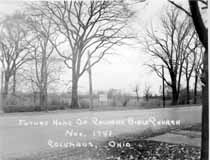 E.A. Fuller was a prominent Clinton Township horse trader at the turn of the century. I found the Clinton Township records for the late 1800s and early 1900s, and his name was frequently mentioned as buying or selling horses. I assume that the so-called “Fuller Farm”—where Calvary Bible Church, Whetstone Park, Clintonville Women’s Club, and The Church of Christ, Scientist are today—once belonged to this man. (Photo courtesy of Calvary Bible Church)
The vacant farm has been put to many uses. During World War II, the land used for victory gardens. (There were also victory gardens near Riverside Hospital.) Children put the area to their own purposes, scrambling through the undergrowth and playing by the river.  Many long-time residents recall a family that lived in the farm house—some have called it a log cabin, others say it was a chicken coop–of the old Fuller Farm. Some say the family was partly Native American; others say partly Romani; in any case, the family’s race added to their mystique and exoticism in the minds of the Clintonville children of the time. The family’s surname was Windsor; Mr. Windsor was a professor at OSU, and many of the people fondly recall daughter Zolithia [or Zelitha] (back row, 4th from left) and her brother Romanus (3rd rw, 2nd from right).
During or shortly after World War II, Rand Hollenback (founder of The Booster) lobbied for remaining land to be converted into a park, and the City of Columbus purchased the 161 acre farm. It became Whetstone Park. From early on the park has included a casting pond, softball diamond, tennis, picnic and playground, and archery field.