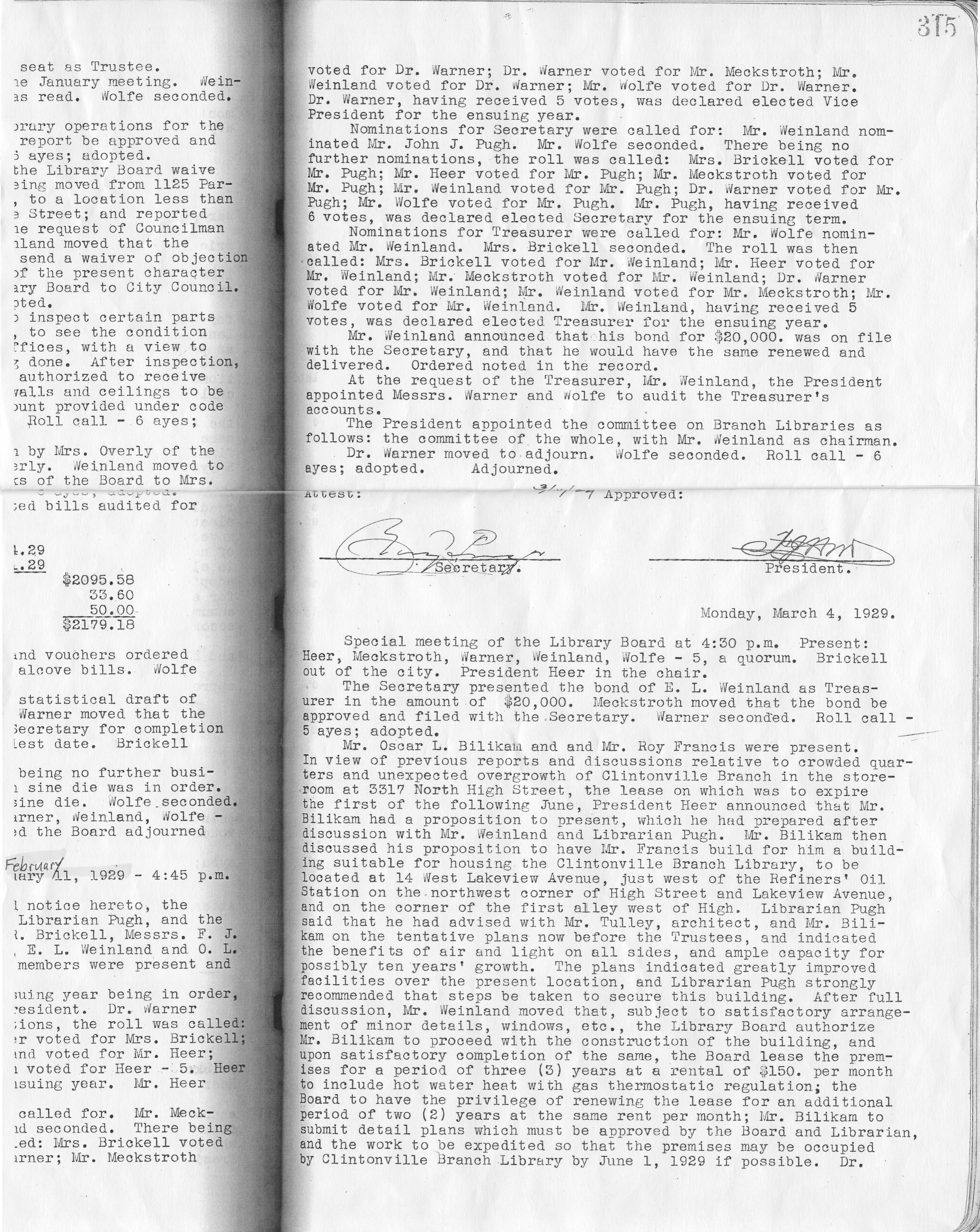
Never Too Many Cookes…(the article)
Saturday, September 27th, 2008I wrote this article for the Clintonville Historical Society newsletter and am reproducing it here for your convenience…
Never Too Many Cookes…
by Shirley Hyatt
© Shirley Hyatt
We often think of Clintonville as having been established in 1847 near the intersection of Orchard Lane and North High Street on Bull family land, but we mustn’t forget that today’s Clintonville extends north to Worthington, and that other families contributed significantly to the development of Clintonville’s northern reaches.
One of the most vibrant little communities was centered near the intersection of today’s Henderson Road and North High Street (or more precisely, Cooke Road and North High Street). In streetcar days this was known as Cooke’s Corners, because it was established by the extended Cooke family.
Roswell Cooke came to Ohio from Connecticut in 1800 with his wife and five children. The two oldest sons, Chauncey and Rodney, took up adjoining land in the vicinity of today’s Henderson Road and North High Street. At the time the land was densely wooded, and the Cookes had to clear the land to establish their farms. By 1827 they operated large productive farms, had built grist and saw mills along the Olentangy River (near Weisheimer Road), and also operated a distillery.
Roswell died in 1827 at the age of 63. Son Rodney (1793-1833), a veteran of the War of 1812, married Laura Cowles and together they had nine children: Esther (married to L. J. Weaver), Roswell (m. Lorinda Skeels), Helen (m. John Good), Rosalia (m. John Webster), Rachel (m. William Buck), Laura (m. Lester Roberts), Rodney Romoaldo (m. Chloe Williams), Demon, and Henry C. (m. Abigail Taylor). Sadly, Rodney died when his youngest child was just 3 months old; wife Laura supported the family by working as a tailor. She herself lived until she was 73 years old.

Genealogies state that Henry C. was born “near Olentangy Park in 1825.” After his marriage to Abigail in 1852, he moved back to the old Cooke family homestead and gradually purchased property from the other Cooke heirs. Eventually he consolidated 300 acres of good productive farmland. Henry and Abigail had seven children: Clara (married to Wellington Webster of Findlay OH), Flora (m. J. L. Armstrong), Albert Clement (m. Lulu Brown), Edwin (m. Ella Haines), Mary (m. David Maize), Alice (m. Charles Hess), and Harry Lester.
Henry C. Cooke worked for awhile as a teacher, then as a farmer. He also went into the stock business (i.e. shipping stock). In 1879 he went into business with A. G. Grant to form Cooke, Grant, and Cooke, which constructed heavy masonry bridges. (This company’s projects may include the present Henderson Road bridge and a few others in the area.) Henry was one of the promoters of the Worthington and Columbus streetcar line. He was prosperous, and built a magnificent house along present-day North High Street at Deland Avenue. (You can see its photo in my book.)

I named the spouses of Henry’s children above to show how tightly knit the community was. The Webster’s family farm was south of the Cookes’ along today’s North High Street. The Armstrongs, the Maizes, and the Bucks, and Albert Clement Cooke, all lived a very short distance from Henry. Daughter Alice—a schoolteacher at the Clinton Heights school—had married one of the great-grandsons of Balser Hess and they lived in Henry’s grand home.
John Buck was one of the early pioneers who received a military land grant in the area; some records state that he sold the original Cookes their land. Descendents of John Buck had a market on North High Street; long-time residents still remember Buck’s market today, and short-time residents may still recall the Buck residence, an Italianate-style house just north of the northeast corner of Henderson and North High. The Bucks were related to the Cookes by marriage.
George Whipp came to the area with his wife and two sons from Maryland in 1833. Whipp had received 160 acres of land in return for military service, and he also purchased the mill property that had been built by the Cookes. (At some point in time the old mill on the river was called “Whipps Mill” and Henderson Road bridge was known as “Whipps Bridge.”) His son George (b. 1817) was initially a carpenter, and was credited with building many of the houses of Clinton Township. Son George married a neighbor named Lucinda Smiley in 1838, and they had 10 children (one of whom was also named George). The family farmed, and though much of the acreage was eventually sold off, the Whipp family continued to own a truck farm in the area. Old timers can still recall the big orange sign for Whipp’s Orange Mill, a fruit stand located at 4588 North High Street featuring fresh squeezed orange or pineapple juice. The Whipps were related by marriage to the Bucks. (Note: sometimes the family spells its name with one “p”.)
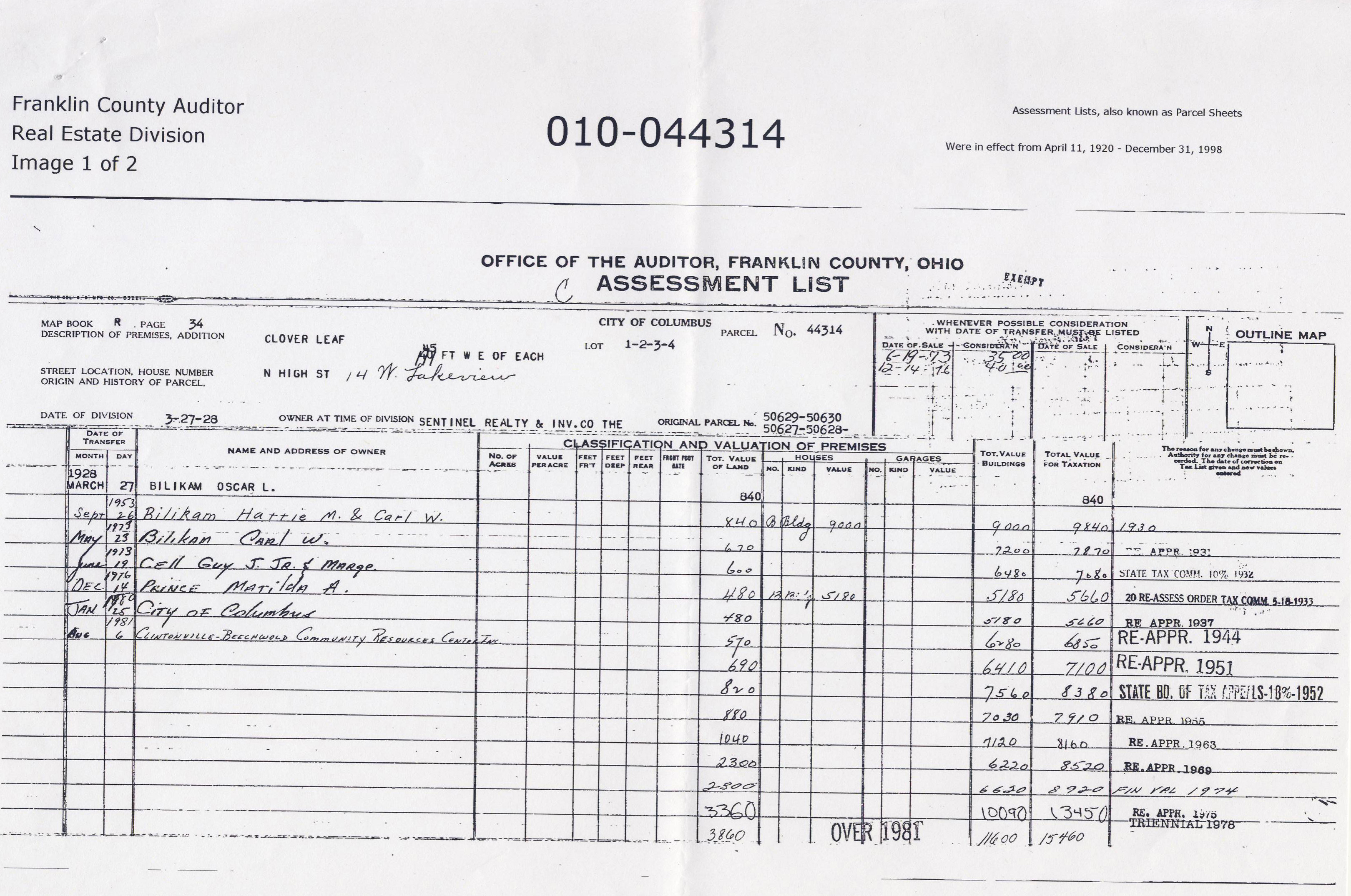
An article about this tightly-knit community warrants mention of two other families, the Aldrich family and the Phinney family. Orlando Aldrich (b. 1840) was a prominent judge, lawyer and OSU law professor. Aldrich was the first president of the Worthington, Clintonville & Columbus Street Railway Company and served in this position from 1891 to 1898; he subsequently held an office of the Columbus, Delaware, & Marion Electric Railway. Aldrich had purchased 23 acres of land on the southwest corner of Henderson and North High in 1882; it was a fruit farm called Maple Grove Farm. Aldrich had three great hobbies: horticulture, collecting great art, and collecting rare books about archaeology. He engaged in these avocations from his lovely house located about where Maple Grove Church parking lot is located today. According to artist and local historian Bill Arter, Aldrich had a magnificent view of the river and OSU campus from the turret of his house. This house was moved slightly, rotated, and completely revamped in the 1920s by subsequent resident Frank Sweigart. (For more information, see my web site, www.clintonvillehistory.com.) It’s from this farm that the area around Henderson Road and North High Street and the church get their names today.
Barnabas Phinney (ca. 1813-1899) came to the area in 1838, and purchased 60 acres of land near the northwest corner of today’s Henderson Road and North High Street. In addition to farming, Phinney was an investor in the toll road running from Columbus to Worthington, and in the electric streetcar company. He married Mary Smiley and was probably brother-in-law to George Whip. Their house was said to be majestic. They had no children, and after his death most of the property was sold. At some point (circa 1893) the house was sold to the Schreyer family, and then chopped into apartments. I would love to see a picture of this grand old home. In 1913 a fire broke out; the city fire department was called but there were no water lines that far from the city, and so the building burned to the ground. (Luckily, no one died in the blaze.)

By the early 1900s, this was a tight and thriving community. The houses were handsome. The Cooke family held annual reunions at the Cooke house—old photos show the family eating at long tables arranged in the shape of a “C,” and they kept an ongoing register with names of attendees and minutes. The community held plays to entertain each other, went sledding on today’s North High Street, went horseback riding along Indian Springs Drive, worked and had fun, and worshipped.
The original Cookes were said to be Universalists, but somewhere along the way most of them became Methodists. In 1842 Chauncey Cooke had leased a 32-foot by 99-foot portion of his land on the corner of Henderson and North High to the Clinton Township School district to be used for both education and religious purposes. A school house was built in 1878, and it was used by the Clinton Township School District as well as by local Christian worshippers. When Orlando Aldrich purchased his beloved Maple Grove fruit farm, his tract surrounded the school and church property, and Aldrich expanded the land dedicated for school and church purposes to three-quarters of an acre. In 1919, when the school district had ceased using the building for educational purposes, ownership of the building and land reverted to the Cookes. Family members agreed to sign quit claims, and the property was put into the hands of the Como Avenue Methodist Church until a neighborhood church could be formalized. In 1920 Maple Grove Methodist Episcopal Church officially organized and assumed ownership of the church they had probably long worshipped in.
The Cooke family had a family cemetery located on the southeast corner of Cooke and High. When Bishop Watterson High School was built in 1958, the graves were disinterred and moved to Union or Greenlawn Cemeteries.
Luckily the activities of the neighborhood were documented by Lulu Brown Ohsner–a Cooke family member, neighborhood resident and parishioner of Maple Grove Church who has since passed away—in some presentations to Maple Grove Church about 15 years ago. And, many Cooke and Whipp family members still live in the Columbus area, and have family photos and memorabilia. Henry C. Cooke’s contracting company Cooke, Grant, Cooke is still in existence; the current name of this company is the Fritz-Rumer-Cooke Co., Inc. It incorporated in Ohio in 1911, and still specializes in railroads and other general contracting. Sadly, most (though not all!) of the lovely homes owned by the Cooke family members have been torn down.


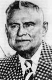 Patrick Murnan lived from 1866-1937, and owned about 700 acres along North High Street north of Morse Road. I’m not going to repeat the story of Murnan here; it’s in my book. But, here’s a photo of the man himself.
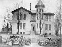 I would love to find a photograph of the original school at Clinton Heights and North High Street. According to one or two accounts, a Brevoort family member living in Michigan has one. The school pictured here ca. 1905 was the second Clinton Heights school building. It was yellow brick, contained 4 rooms, and faced High Street. Since students attended from all over Clinton Township in those days, many rode horses to school; the barn at the back was probably used for horses. According to the photo caption, most of the school moved into High Street for the picture. An interurban rail went up the center of High Street at the time, and the photographer probably stood on the tracks to take this picture. (Photo courtesy of Amy Westervelt)
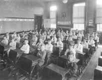 This is a picture of children in the classroom of the Clinton Heights school. (Photo courtesy of Amy Westervelt)
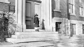 The second Clinton School was built in 1895 at 10 Clinton Heights Avenue. At the time, it housed both a grammar school and a high school. In 1904, the Clinton Township High School Building was built (pictured); it remains today as the Clinton Elementary East Building. A successor to the original building—still used–was built in 1922. (Photo courtesy of Amy Westervelt)
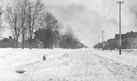 Overcrowding has been a chronic problem for schools. This photograph, looking east up Clinton Heights Avenue, shows some of the portable school buildings that were used as classrooms until newer school buildings could be erected. (Photo courtesy of Amy Westervelt)

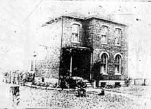 The township school located at Clinton Heights Avenue and North High Street did not, originally, have running water. Every day a child was designated to carry one bucket and dipper across High Street to the Chesnut house (see page 12 in my book, Clintonville and Beechwold) to fetch water that would be shared by the students. Legend has it that there were no lack of volunteers for water duty, as Mrs. Chesnut (or perhaps it was her daughter Fannie) always had cookies for the volunteer. This is a bad, yet significantly older, image of the Chesnut house.
 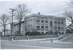 Overcrowded schools were a chronic problem, and the schools supplemented their brick-and-mortar ediifices with portable buildings. In response to the overcrowding of the east building, Clinton Elementary School’s west building was constructed in 1922. Both the east and west buildings have been in use for elementary and kindergarten grades since that time. (Photo courtesy of Columbus City Schools)
