Good News, Bad News
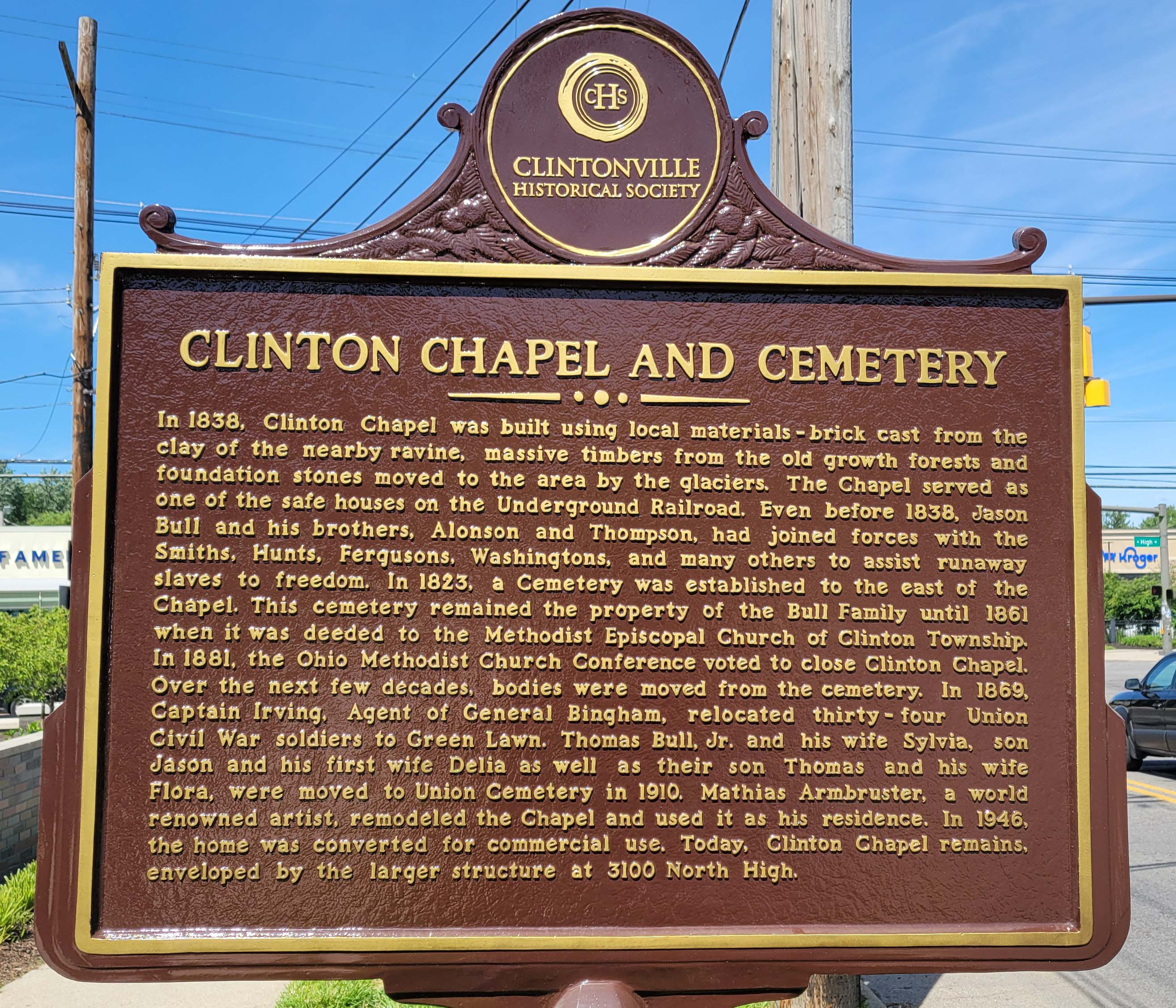
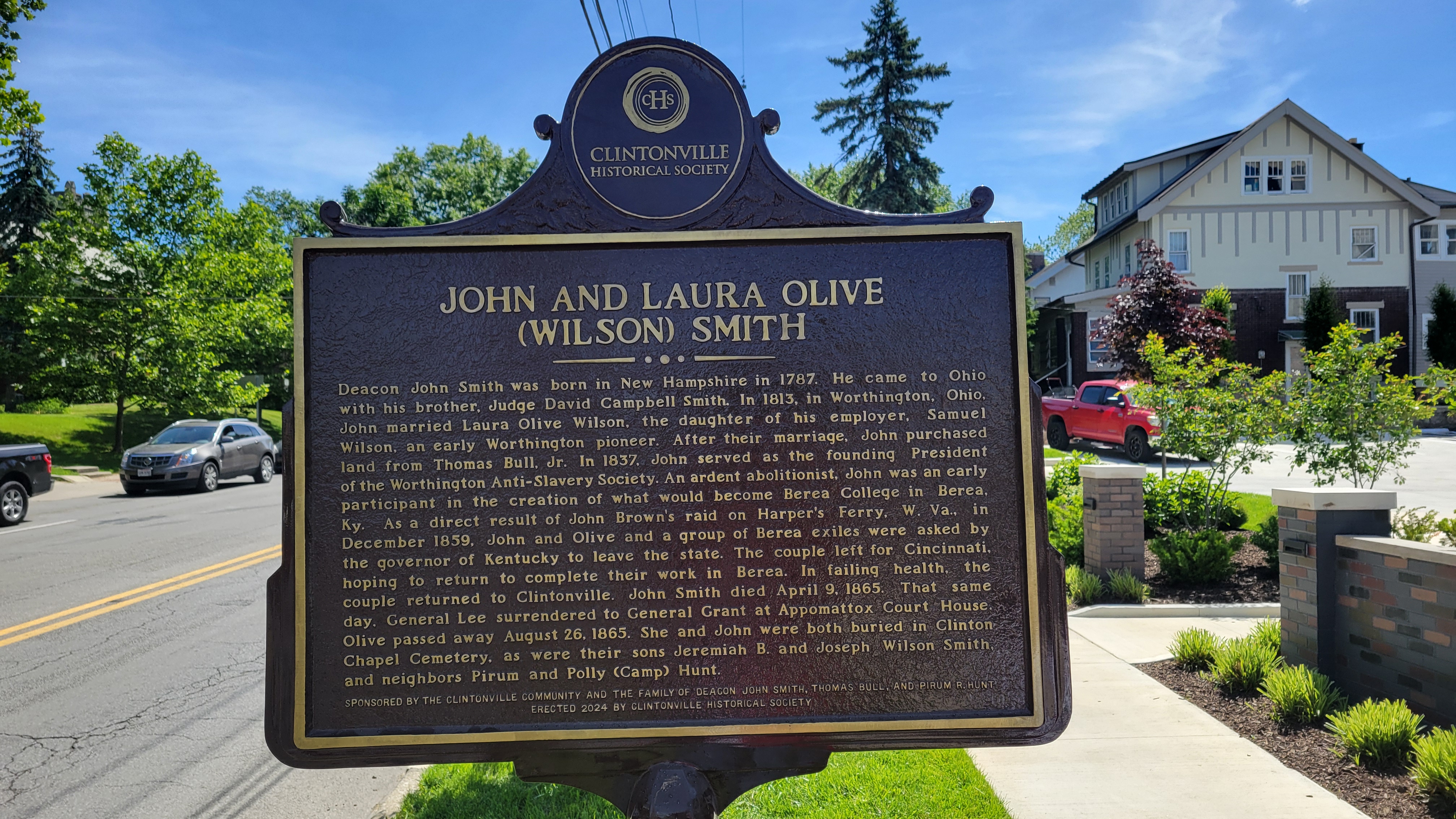
On the bright side: Clintonville Historical Society has erected a new plaque for the Clinton Chapel and for John and Laura Olive (Wilson) Smith near the corner of East North Broadway and North High. It gives us pause to remember slaves and slavery in the Unites States and to give thanks to the people who fought against it.
On the bad news side: it’s very unfortunate, from my perspective, that 12 staff were recently laid off from Ohio’s Historic Preservation Office. The federal government mandates that every state must have this sort of office, and to accompany that mandate they give the offices some money to fulfill their mission. That money was apparently withdrawn by DOGE and so Ohio History Connection had to terminate staff. Here’s a link to a newspaper article about the staff terminations.
[Photos courtesy of Joe Smith.]Maps Maps Maps
Here are some cool links for old maps:
City of Columbus Planning Maps, Historic Maps.
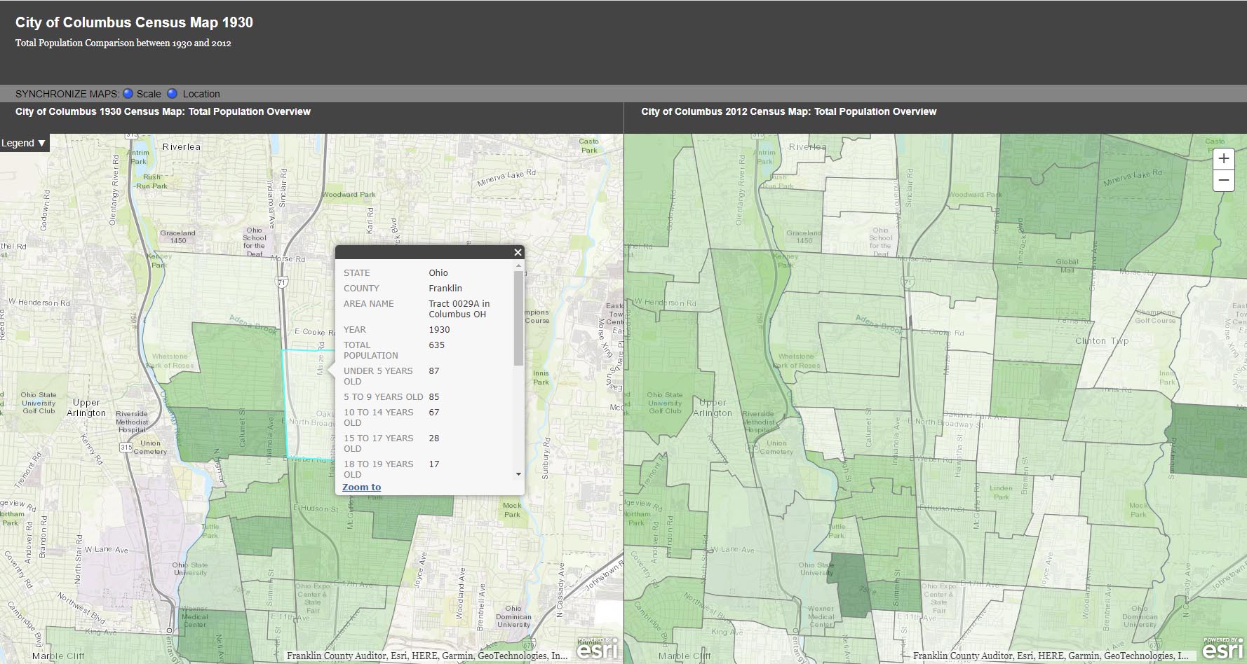
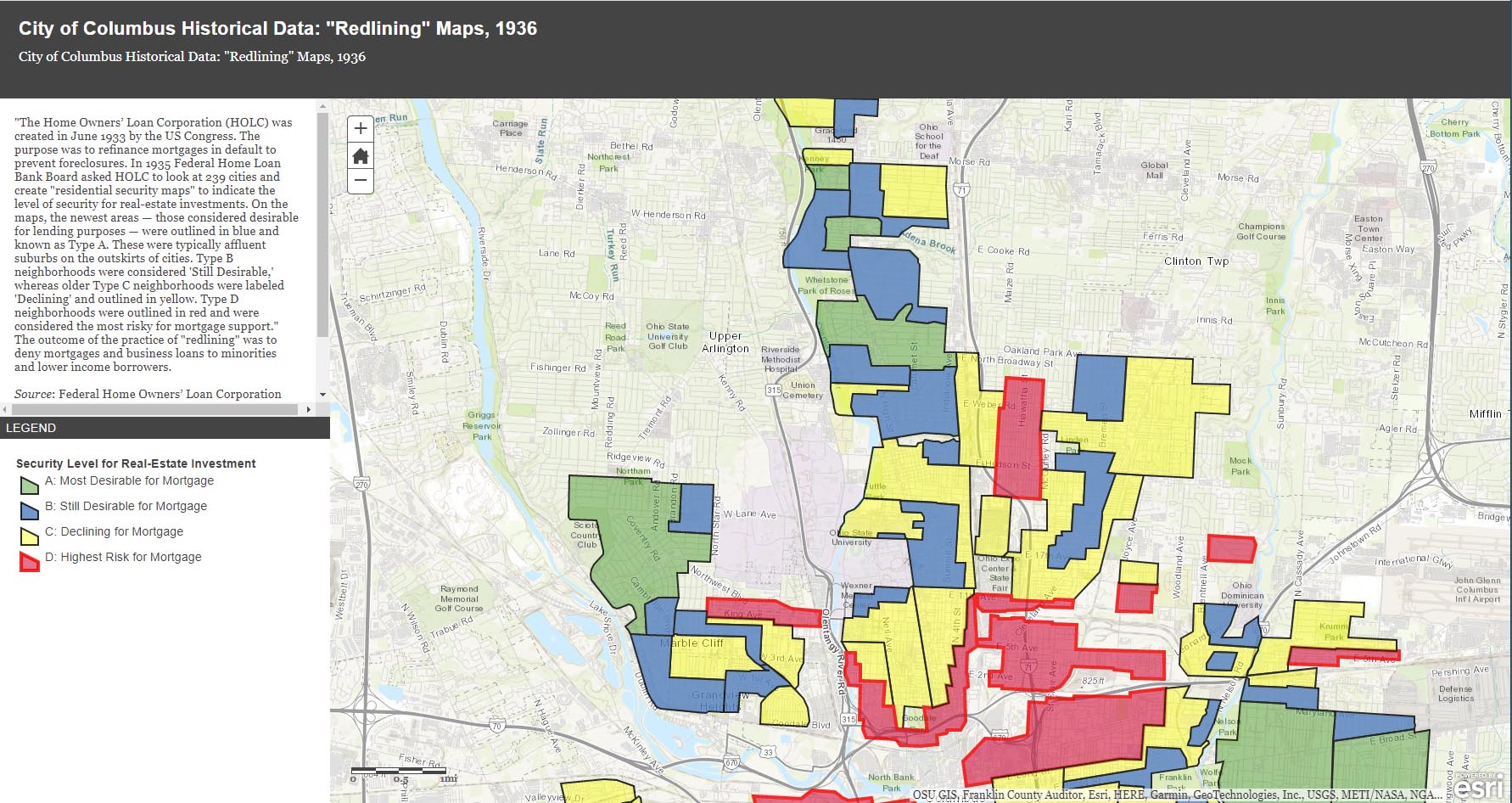
The City of Columbus’ web site gives us plenty of maps and data to play with, from Census demographic changes to despicable redlining and more. Check out especially the “City of Columbus Historic Panoramic Images, 1922,” which is based on a 1922 Ohio State University masters thesis by Forest Ira Blanchard. “Blanchard, inspired by the Chicago School of Sociology, sought to study the racial and ethnic composition of the city, with a particular focus on the role of transportation (railroads, roads) in shaping the urban landscape. Source: Forest Ira Blanchard, An Introduction to the Economic and Social Geography of Columbus, Ohio. Thesis (M.A.), Ohio State University, 1922.”
Columbus Metropolitan Library’s Columbus and Ohio Map Collection. If you haven’t donated to the library yet, now’s the time! It and and it’s staff are such great resources.
Sanborn Maps for Franklin County (scroll down to see Columbus). This is a Library of Congress site.
USGS Historical Topographic Map Explorer allows you to specify a place you want to explore, then click on a location to see its historical maps.
Prolific programmer Randy Majors has produced several products of interest, including his Historical U.S. Counties Map Tool and Auto-Checker Extension. He has also created a couple of video walkthroughs of a couple of the the software tools he has created. I recommend you view them in order, as understanding the Historical U.S. Counties map tool will help you have better success with using the Auto-Checker chrome extension.
Old Maps Online OldMapsOnline.org indexes over 400,000 maps, thanks to the archives and libraries that were open to the idea and provided their online content.
Do you know of other map resources? Let me know and I will add them to this post.
OHC Discovery Tool
 Nancy Campbell, my historic-preservation go-to person–and the author of the Truman and Sylvia Bull Coe House and the A.B. Graham National Register of Historic Places nominations–shares a new feature on the Ohio History Connection web site. You can now search all of OHC’s archival collection (audiovisual, manuscripts, State Archives) and library (books, maps/atlases, newspapers, pamphlets, printed government documents) in one spot by following the link provided below:
https://ohiohistory.on.worldcat.org/discovery
Archival records will be indicated by an “Archival Material” note and include basic information about the collection. For more details, including locations and container inventories when available, click on the “View Record in ArchivesSpace” link toward the bottom of the record.
The “Libraries Worldwide” feature works, and is built into the system that hosts the catalog.
Of course my search in the illustration to the left, was for “Clintonville!”
And More Markers!
Ron Irick recently alerted me to the Historic Marker Data Base. In it are photographs of several additional markers covering Clintonville’s notable people, places and events. The database includes the marker for Rand Hollenback, on Hollenback Drive at Whetstone Park, the Nat’l Register of Historic Places marker for East North Broadway Historic District, and the marker (currently in Powell) for the Grand Carousel which was formerly at Olentangy Olentangy Park.
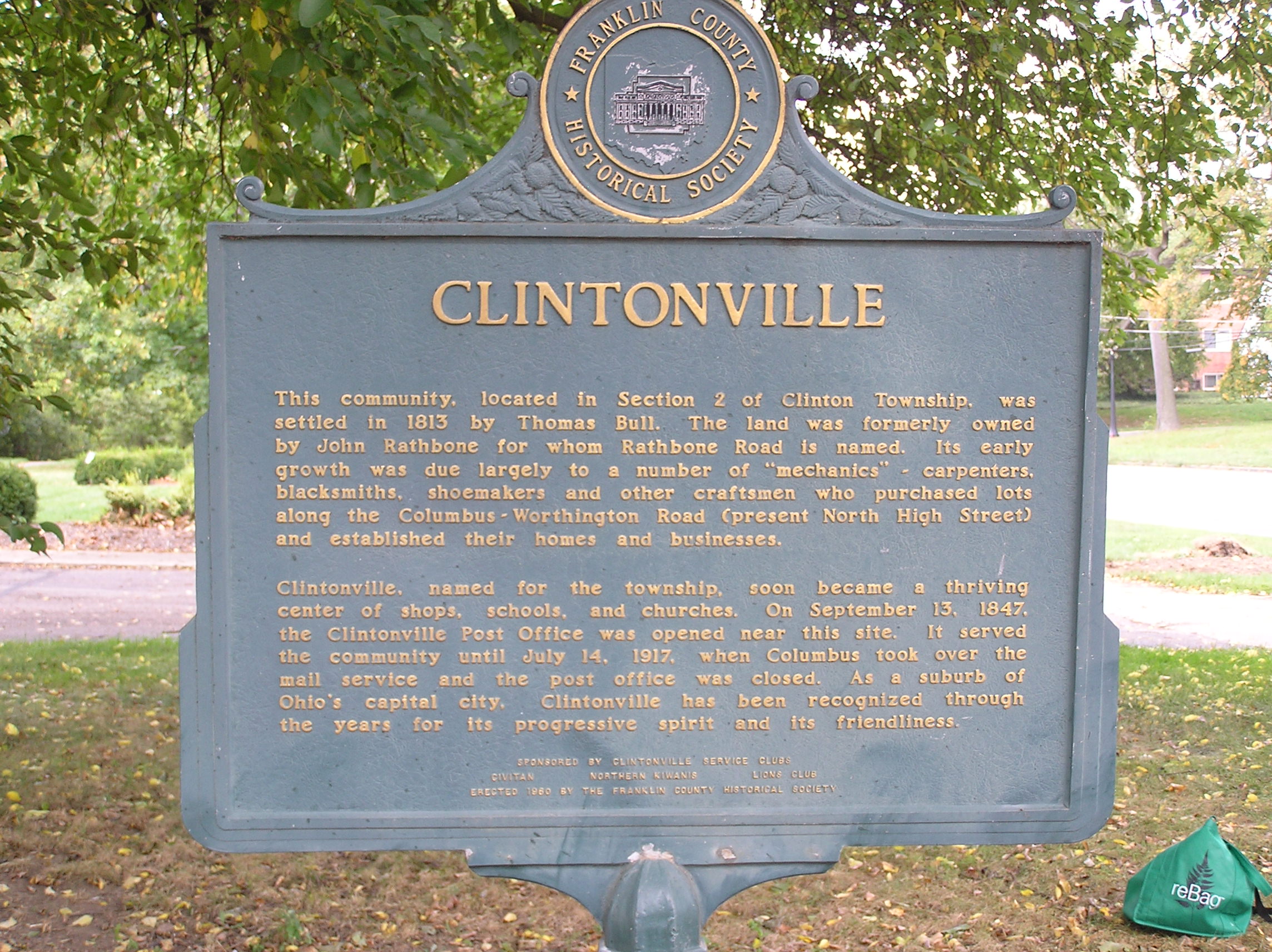
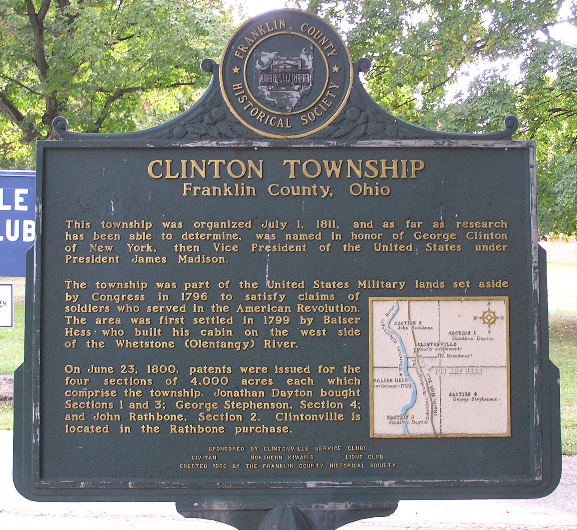
Ron recently posted the Clinton Township/Clintonville Historic Marker.
Though not in this database, there is also a marker for the Old Beechwold Historical District. I believe there is also some sort of marker for the former home of the Republican Glee Club at 57 Weber Road.
The Grand Carousel–Request for Information
Carousel expert and author Eric Pahlke recently emailed me with a question. The question is about the Grand Carousel that currently operates at the Columbus Zoo & Aquarium.
Eric is trying to resolve some conflicting information about the history of the carousel. He writes,
The oft-repeated story is that the carousel came to Olentangy Park in 1914, and was moved to Scioto Ranch Park in 1937-38 after Olentangy closed. Scioto later became Zoo Park, which became Wyandot Lake Park, which is now a combination of Zoombezi Bay and Jungle Jack’s Landing. I have a source that says the city of Columbus bought the carousel in 1981. The carousel apparently operated at Wyandot Lake until 1999 and has been running at the Zoo since 2000.
The problem is that I have some photographic evidence that says the carousel started on Coney Island and didn’t come to Ohio until the mid-1920s. This alternative story doesn’t distinguish between the carousel then coming to Olentangy Park and then to Scioto, or directly to Scioto.
I’m hoping that someone has materials in their archives that would help solve this dilemma. The primary question is whether the carousel came to Olentangy Park in 1914 or sometime in the 1920s. After that is solved, the other issues probably follow.
Does anyone have any information that could shed light on the issue? Eric is the author of Treasures from the Golden Age: West Coast Carousels, and Treasures from the Golden Age: East Coast Carousels.
New Posts December 2013
 Until today, I’ve arranged material on this web site roughly in chronological order; information about earlier events at the top, and more recent history has been put at the end of this web site. For your ease in locating newly posted material, I’ve listed fresh content and any changed entries in the “Recent Postings” category. Arranging the listings this was is quite a bit of labor, though, so as of this month, I’m throwing in the towel. From now on, new postings will be put on the front page, willynilly, regardless of their era.
Wondering who these people are?
The people at the top of my banner, I mean. Well, I am wondering too. I believe this is the Hollenback family (the family that started The Booster, and who lived on High Street) but I have been unable to confirm who the pictures are of, or where the photos were taken.


Historical Maps
UPDATED POST: Maptech used to host the collection of Historical USGS topographic map collection that was started by rail historian Chris Marshall, but apparently it does not appear to do so anymore.
USGS’s collection of historical maps is one of my favorite resources for old USGS topographic maps.
It’s a bit tricky to use. All the scanned maps are in quarters. I usually start with the town index (not the quad index) and work my way through the four quarters of the quad map until I find the area I’m interested in. Buildings, schools, and churches are indicated.
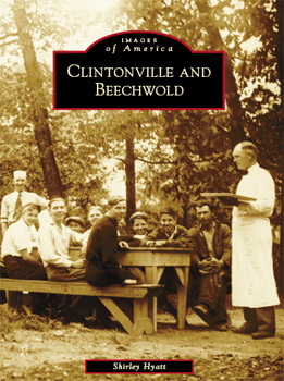
How did I decide?
I’ve received a few questions about how I went about collecting photographs for my Clintonville and Beechwold book—and why I left some subjects out. Here’s my process. I began by identifying and contacting all the churches and schools in Clintonville. Some churches, like Crestview Presbyterian, had no photographs; others did not, for one reason or another, return my calls. I also hung flyers around town requesting photographs, and spoke with local merchants. I notified The Booster, This Week in Clintonville and several alumni newsletters; both newspapers and several newsletters ran articles about my project. I held open scanning sessions at Clintonville Historical Society meetings and at the Whetstone Branch of the Columbus Metropolitan Library. I researched history and made lots calls to families and businesses that had a hand in creating Clintonville’s history. And so on…
Clintonville on Registers of Historic Places
These are the Clintonville places that are presently listed on the National Register of Historic Places:
- Berry, Richard Jr., House (Also known as Tomko House)
324 East North Broadway, Columbus - Coe, Truman and Sylvia Bull, House
75 E. Lakeview Ave., Columbus - East North Broadway Historic District
Bounded approximately by Broadway Place (a little to the east of North High) on the west to the railroad tracks on the east - Glen Echo Historic District
Roughly bounded by Glen Echo Ravine, Big Four RR tracks, Indianola Ave., and Hudson St., Columbus - Graham, A.B., House159 Clinton Heights Ave., Columbus
- Hamilton, Gilbert H., House
290 Cliffside Dr., Columbus - North High School (Also known as North Adult Education Center High School)
100 Arcadia Ave., Columbus - Old Beechwold Historic District
Roughly bounded by W. Jeffrey Pl., N. High, River Park Dr., and Olentangy Blvd.
(I realize Glen Echo neighborhood and the Gilbert Hamilton house are not quite in Clintonville but they are so close, I included them in this list.)
In addition, the following two places are listed on the Columbus Register of Historic Properties:
- Northmoor Engine House
3601 N. High Street, Columbus - Weisheimer House
286 W. Weisheimer Rd., Columbus
Clintonville in Historical Markers Programs
At present Clintonville has 3 historical markers that are on the Ohio Historical Markers Program.
An additional marker in Clintonville was originally sponsored by the Franklin County Historical Society and recently “adopted” by the Clintonville Historical Society. It has recently been refurbished and returned to its original location on the northeast corner of North Broadway and North High Streets. (In 1971 it was moved from the North Broadway location to a spot near the Clintonville Women’s Club to make way for a gas station at North Broadway & High.) The pictures below show the marker before it was refurbished by the Clintonville Historical Society.
There may be other markers in Clintonville and if so I would love to learn about them.
Wouldn’t it be nice to see more of Clintonville’s history told via these markers? For starters, here is a list of possibilities (in no particular order):
- Site of Olentangy Park
- Site of Olentangy Bowling Alley, reputed to be the first automatic pin-setting machine
- Site of Virginia Gay Home
- Site of old Columbus Zoo
- Clinton Chapel at 3100 North High Street
- Cemetery at Clinton Chapel
- Site of first (original) Clintonville Post Office (see marker above)
- Site of Bill Moose encampment and cabin
- Site of Beers Mill
- Site of Weisheimer Mill
- Site of Wyandot Country Club aka Elks Country Club (now the property of the School for the Deaf)
- Site of old Beechwold Theatre
- Studio 35
- Park of Roses
Applications for the Ohio Historical Markers Program flow through the Ohio History Connection. A 2008 Dispatch article stated that markers cost as much as $2150, and that the Ohio Historical Society’s Marker program provides grants of $750 to 20 proposals each year.
The Clintonville Historical Society has recently launched its own campaign to get more markers on the street. They hope to get funding for 3 markers soon:
- Beechwold/Urban Cottages to be placed on High at Dominion,
- Memory Lane/Post office to be place on High at Orchard, and
- SunwallMoonwall Murals/Dominion Land Co. Mound to be placed on Cooke at Indianola.
They plan to select additional markers based on feedback they receive from the community. Their goal is to install 10 markers in 2016. Plans are to obtain that feedback via a display installed at the Whetstone Library in April or May 2016. People interested in funding a marker should contact the Society by phone 614-657-6854 or email mrodger5@columbus.rr.com.
Wish list for photographs
My wish list for photographs (an ongoing list):
- Bliss College
- Bowling Alley at Graceland
- Broadway Canoe Club
- Capitol Dougnuts
- Clinton League’s tennis courts on Dunedin
- Clintonville Bridge Club
- Clintonville Lumber Company
- Columbus Canoe Club (on Orchard)
- Cyro’s Market
- Ferrill’s at Graceland
- Fleming’s Book Store at Graceland
- Florence Restaurant (advertised in 1927 as being “Clintonville’s Best and Most Popular Eating Place,” at 3274-76 North High)
- Gratziano’s Market
- Hansen’s Bakeries
- Indiaoaka Service Station
- Murry’s, the IGA where Weiland’s Market is today
- Whip’s Vegetable Garden, at 4558 North High Street, at “Mill Road” (Weisheimer Road today)
- Santa arriving at Graceland (on the Friday after Thanksgiving) by helicoptor
Clintonville’s Historic Inventories
Historic Inventories are brief “snapshot” assessments of buildings to determine whether the buildings are of historic interest. Just 1 or 2 pages in length, an inventory is intended to provide a brief description of the location, background, and architecture of a building, site, structure, or object of architectural or historical significance.
The inventories have been written by students or by dedicated residents such as those in the Old Beechwold area, under the auspices of the Ohio Historical Society Historic Preservation Office. (The Beechwold residents did an especially terrific job of inventorying their neighborhood.) For more information about Ohio Historic Inventory Program, click here.
I’ve made a map of the places in Clintonville that have been inventoried; click on the thumbnail to the right to see it.
Linked below, in PDF format, are the historic-inventories for buildings in Clintonville as of July 2008.
Old Beechwold:
Old Beechwold Historic District Nomination
4765 North High, aka “the Gatekeeper’s House,” and also this version
4475 North High
44 West Jeffrey Place
177 West Jeffrey Place
30 West Beechwold
62 West Beechwold
80 West Beechwold
100 West Beechwold, and also this version
150 West Beechwold
209 West Beechwold
4783 Olentangy Blvd
4793 Olentangy Blvd
4805 Olentangy Blvd
4817 Olentangy Blvd and also this version
4820 Olentangy Blvd
4827 Olentangy Blvd
4831 Olentangy Blvd
4837 Olentangy Blvd
4935 Olentangy Blvd
23 West Riverview Park
75 West Riverview Park
81 West Riverview Park
121 Riverview Park
197 Riverview Park
157 Rustic Bridge
222 Rustic Bridge
4787 Rustic Bridge
4795 Rustic Bridge
4857 Rustic Bridge
4866 Rustic Bridge
4876 Rustic Bridge
4 West Royal Forest
52 West Royal Forest
91 West Royal Forest
115 West Royal Forest
128 West Royal Forest
201 West Royal Forest
North Broadway:
65 East North Broadway
77 East North Broadway
150 East North Broadway
155 East North Broadway
162 East North Broadway
177 East North Broadway
456 East North Broadway
489 East North Broadway
Elsewhere in Clintonville:
3119 North High
3377-3381 North High (Clinton Theatre)
3783 North High
3535 North High
149 East Kelso
45 East Crestview
238 Crestview
129-131 West Weber
259 Walhalla
334 Walhalla
224 East California
91 West Longview
191 West Delphi
314 West Kanawha
163 Kenworth
203 Kenworth
265 Kenworth
285 Kenworth
289 Kenworth
629a Oakland Park
645 Oakland Park
189 Northmoor
3624 Weston Place
214 Arden (a Lustron home)
100 Webster Park
213 Webster Park
7 West Henderson (Maple Grove Church)
45 Weisheimer
239 Weisheimer
286 Weisheimer
And (technically) just south of Clintonville:
100 Arcadia (Old North High School)
Glen Echo United Presbyterian Church
290 Cliffside Dr
17 West Dodridge
44 West Dodridge and 44 West Dodridge
96-98 East Dodridge
Art and Artists in Clintonville
 In addition to compiling a list of Clintonville’s “notable people,” I have often wanted to see a list of Clintonville art and artists. My list might include:
Jodi Kushins, artist of Smith’s Deli external mural
Smith’s Deli’s indoor murals as well
Chad Bender (children books)
Jerry Devine (chain saw art, out of Como Mower Service & Sales on Indianola)
Harlow Ballard (digital art)
Tim George (Etch-a-Sketch artist)
Chester Nicodemus (ceramics)
Mac O. Shaffer (photographer)
Fred Shannon (photographer)
Mathias Armbruster
Art in Clintonville churches
Marlo Bartels’ Skyline mural formerly at Clinton Elementary School
Please add to my list in the Comments below!
Locations in Clintonville & Beechwold Book
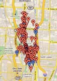 Several people mentioned to me that they’d used my Clintonville and Beechwold book as a driving tour of Clintonville. To make it more convenient to do so, here’s a Google map of all the locations in my book.