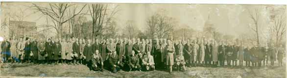
Lust You Be Tempted…
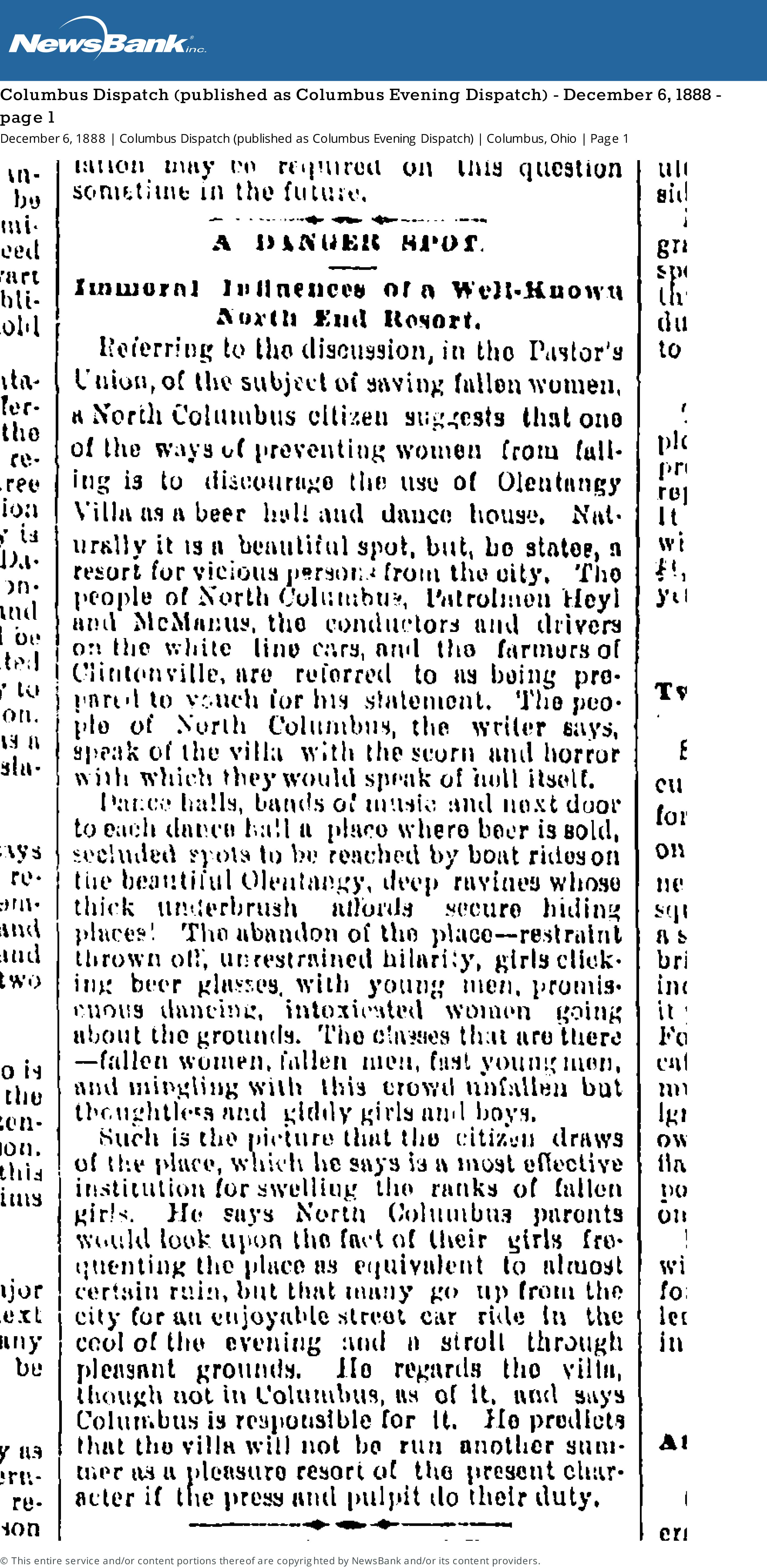
[From the Columbus Dispatch (published as Columbus Evening Dispatch) Thursday December 6, 1888 page 1]A danger Spot
Immoral Influences of a Well-Known North End Resort
Referring to the discussion, in the Pastor’s Union, of the subject of saving women, a North Columbus citizen suggests that one of the ways of preventing women from falling is to discourage the use of Olentangy Villa as a beer hall and dance house. Naturally it is a beautiful spot, but, he states, a resort for vicious persons from the city. The people of North Columbus, Patrolman Heyl and McManus, the conductors and drivers on the white line cars, and the farmers of Clintonville are referred to as being prepared to vouch for his statement. The people of North Columbus, the writer says, speak of the villa with scorn and horror with which they would speak of hell itself.Dance halls, bands of music and next door to each dance hall a place where beer is sold, secluded spots to be reached by boat rides on the beautiful Olentangy, deep ravines whose thick underbrush affords secure hiding places! The abandon of the place–restraint thrown off, unrestrained hilarity, girls clicking beer glasses, with young men, promiscuous dancing, intoxicated women going about the grounds. The classes that are there–fallen women, fallen men, fast young men, and mingling with this crowd unfallen but thoughtless and giddy girls and boys.
Such is the picture that the citizen draws of the place, which he says is a most effective institution for swelling the ranks of fallen girls. He says North Columbus parents would look upon the fact of their girls frequenting the place as equivalent to almost certain ruin, but that many go up from the city for an enjooyable street car ride in the cool of the evening and a stroll through pleasant grounds. He regards the villa, though not in Columbus, as of it, and says Columbus is responsible for it. He predicts that the villa will not be run another summer as a pleasure resort of the present character if the press and pulpit do their duty.
Olentangy Park, from Alex Campbell
Transportation expert and collector Alex Campbell sent along some Olentangy Park pictures. Though you may or may not have already seen these pictures, Alex’ knowledge is invaluable. From Alex:
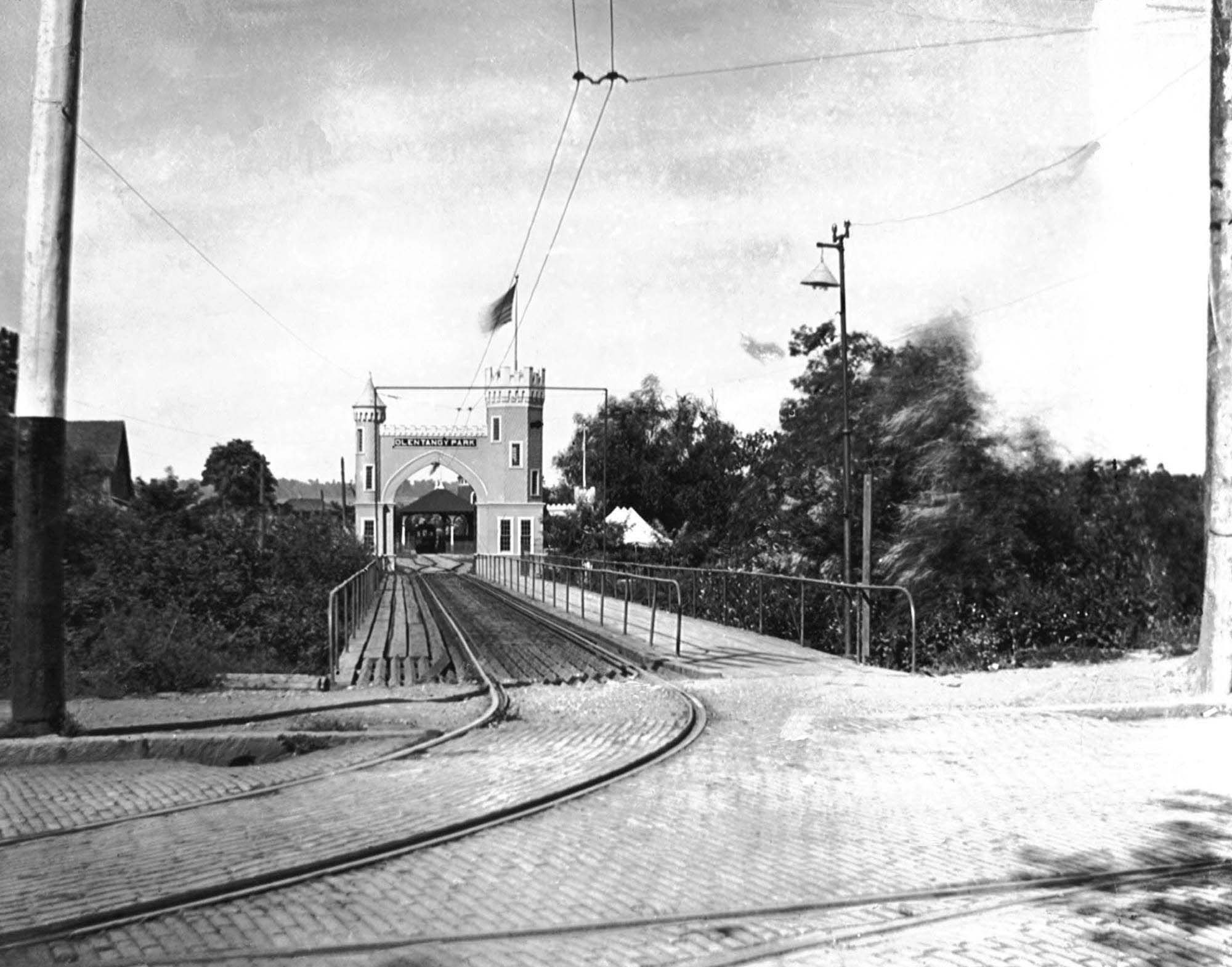
This is the streetcar and pedestrian entrance to Olentangy Park. Olentangy Park was purchased by the Columbus Railway & Light Co. in 1897 as a way to generate business. The high Street line ended at Arcadia. The North High Streetcar house was on the northeast corner of Arcadia and High Streets and directly across the street this park entrance. The Clintonville–Worthington streetcar line terminated at Arcadia as well hence the need for the pedestrian walkway.
Glenn Echo ravine runs east-west along the north side of the ravine. Crossing under the bridge is a north-south ravine that paralleled high Street. More on the north-south ravine on Wednesday.
The single track branches into two tracks, perhaps a loop. There is a loading platform beyond the arch. The single track into the park is going to be unsatisfactory as you will see on Wednesday.
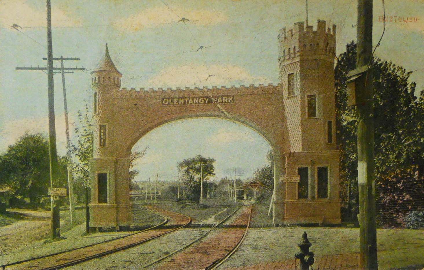
In 1907 the streetcar entrance to Olentangy Park was rebuilt. The ravine paralleling High Street was filled in eliminating the bridge. The inbound and outbound cars no longer had to share a single track. The Clintonville-Worthington visitors still had to walk in using the gravel path to the left of the entrance. (The CR&L Co was wide gauge and the Worthington line standard gauge.)
In 1899 the CR&L Co. sold the park to the Dusenbury brothers who transitioned it from a nature park to an amusement park. The brothers also built a 2248 seat theater.
When the theater let out the surge of streetcar customers must have required tens of streetcars. If they packed the cars with 60 riders each they would need 37 streetcars. That may be the reason the company made the improvements to the park streetcar loop and terminal.
At 5 cents a ride they would have collected $112, good money since they paid so little to their employees.
Alex also put together a super helpful Olentangy Park Chronology as an aid in dating all the Park photos that have shown up in the last few years. (Ohiomemory.org has a number of good Park photos.) Many of the chronology dates came from websites–so they are susceptible to error. Still it does give a sense of the life cycle of the park.
[ca1900 photo from the Christopher Trumbull Collection, by way of Alex Campbell. Postcard postmarked 1909 from the Alex Campbell Collection. Chronology courtesy of Alex Campbell]Olentangy River ca 1957 & 1958
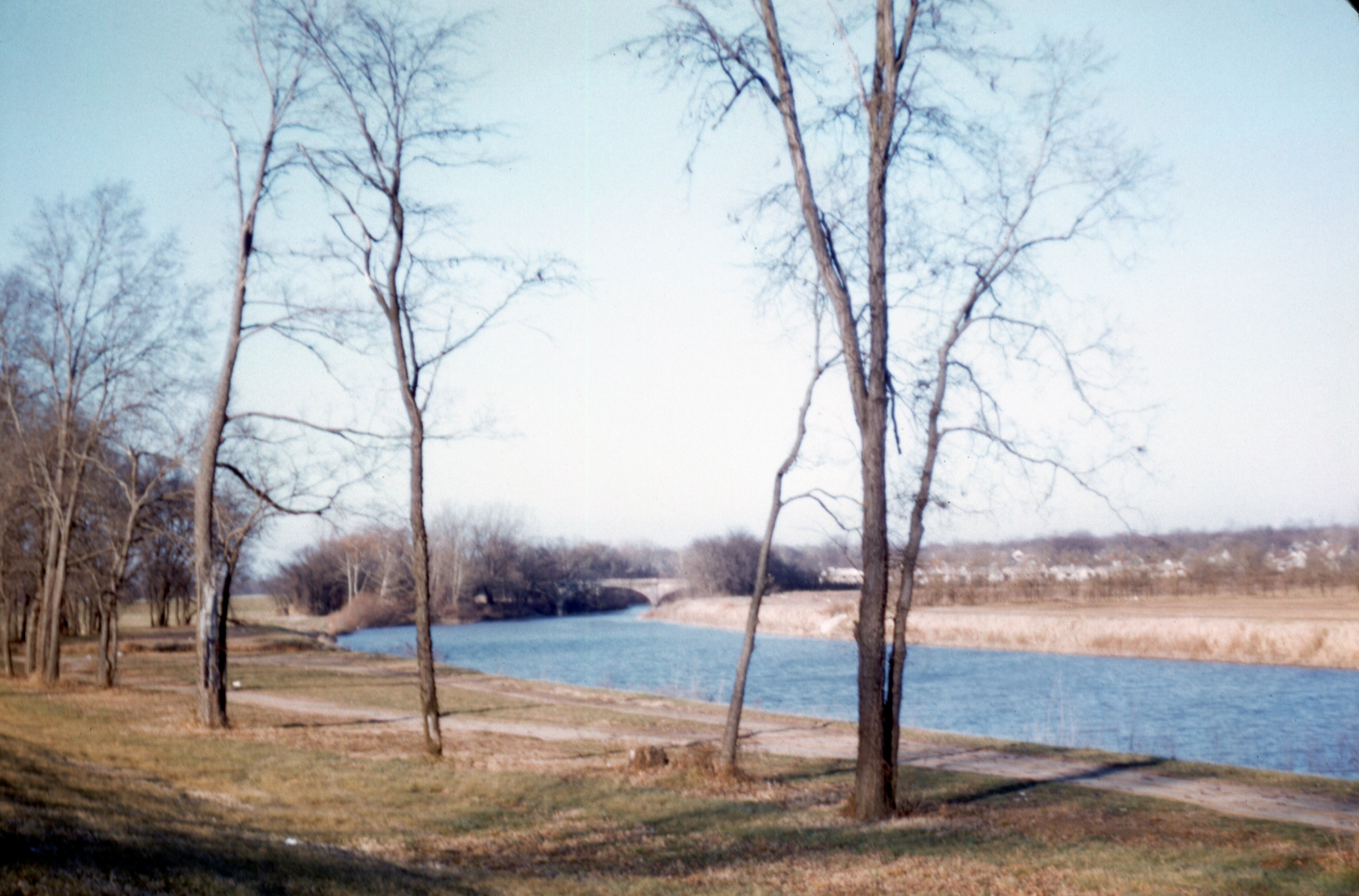
Two nice photos of the Olentangy River in the 1950s.
From Bill Pegues:
[These photos were taken by Frank Pegues and digitized by Jim Pegues, and came to us courtesy of Bill Pegues.]During 1954 my parents moved to Columbus, where my father taught history at Ohio State until 1997. A couple years ago my brother scanned my dad’s slide collection into digital format. My father had documented the location of the scenes in many of them but a fair number lacked any identity. Among these were two shots from an identical point on the Olentangy River in the late ’50s. I spent some time with these and on Google Earth trying to determine where exactly they were taken. Ultimately, I concluded with certainty (based on zooming in on the line of houses visible in the early 1958 photo, and comparing them with the Google Street View of the houses there today, as well as noting the curvature of the river) that they were shot on the west side of the Olentangy just downstream of the old Henderson Road bridge looking north. At the time my parents were renting a house on East Selby Blvd just over the Worthington-Columbus boundary. The preceding photos in the 1957 set were taken at an Ohio State football game that fall, and of the old Lane Avenue bridge as the leaves were beginning to turn. My parents would likely have driven up Olentangy River Road after these games and taken Henderson up to High before driving north to Selby.
The first feature in the 1957 photo that interested me is the parking lot at center-left, indicating that this was a popular spot for people to visit, and probably picnic and stroll around. At the time, SR-315 didn’t yet exist this far north (it wasn’t completed from Ackerman Road north to 270, if I recall correctly, until I was entering high school in 1980) so the only road running along the west side of the river was Olentangy River Road. The second feature of note is that the land on the east side of the river is, accordingly, the open field that would be the location of Whetstone High School (from which my brothers and I graduated in the late ’70s and early ’80s), constructed in 1960-61.
Coasting Along

A roller coaster at Olentangy Amusement Park. [Photo courtesy of Galen Gonser]
The Clintonville Woman’s Club: the women before the Clubhouse
 Mary Rodgers has written a very nice article about the Clintonville Woman’s Club.
The Clintonville Woman’s Club: The Women Before the Clubhouse
by Mary Rodgers
[Courtesy of Mary Rodgers]I was recently asked to speak at an evening meeting of the Clintonville Woman’s Club. Specifically, I was asked to speak on the subject of the history of the land that the Clubhouse occupies. I have always understood that the Clubhouse was located on land from the old Fuller Farm. I was surprised to learn more about the “Fuller” family.
In the 1820s, John Rathbone sold farm lot 5 to Edward Amaziah Stanley. Using today’s landmarks, that land would have been bounded on the east by Indianola Avenue, on the west by the river, on the south by roughly Torrence Road and on the north by roughly Overbrook Drive. When Mr. Stanley died in 1862, his land holdings were passed down to his children. Harriet Marie Stanley (aka Hattie) was one of those children. She was born in Connecticut in 1831. Based on the extensive land holdings throughout Ohio, I believe her father Edward was an Ohio land speculator. After acquiring several thousand acres, in 1829, he returned to Connecticut to marry Abagail Talcott Hooker. Sometime between 1831 and 1834, the family moved to the Clintonville area.
In 1856, Hattie married Erskine Asa Fuller, aka E. A. Fuller. E. A. was known as a dealer in stock animals. When her father passed away, Hattie inherited all of farm lot 5 in Clinton Township Ohio. The 1870 census shows a large extended family living together in Clintonville–the Fullers and their daughters, Hattie’s mother, brother, sister, and several farm hands and servants. The combined household value per that census was in excess of $25,000. Hattie passed away in 1879. E.A. passed away in 1894. After their deaths, the farm was transferred equally to the four Fuller daughters–Abby, Mary, Katherine and Martha.
Martha Fuller and her sister Katherine Fuller Peters lived all of their lives in Clintonville. They owned two brick homes along High Street–Katherine’s just south of where the Library sits today and Martha’s where the Christian Science church sits today. Martha Fuller passed away in 1938. She left half of her land holdings to long time farm hand Matthew McCallen and half to her niece (sister Mary’s daughter) Helen Osborn.
Eventually, all the land was sold off, some to the Christian Science Church, some to the Calvary Bible Church, and the balance to the City of Columbus.
The Clintonville Woman’s Club land was purchased by the Kiwanis Club of Northern Columbus. That Club loaned the ladies the funds needed to build the Clubhouse. In turn, they held a mortgage on the property. The Woman’s Club members worked tirelessly and retire their debt to the Kiwanis within five short years! They have owned the Club house and property ever since.
The ‘ville Is Alive, with the Sound of Music…
 At a recent CHS meeting, Glenn Williams and Stuart Smith shared a song commissioned by the Clintonville Community Band for its 20th anniversary. Snapshots of Clintonville premiered on Oct 1, 2005. It is 11-minute 47-second duration.
Snapshots of Clintonville‘s composer was Barry E. Kopetz, who was Director of Bands and Professor of Conducting at Capital University at that time. Richard Burkart was the Clintonville Community Band’s director. The band has kept a great archive of its history; the program for this concert is here and the announcement of the commissioning of the piece is here.
The individual movements are
1) Main Theme
2) Gothic Gateway Entrance
3) Glen Echo Ravine
4) Bill Moose – Last Of The Wyandots
5) Dance
6) From The Banks Of The Olentangy
7) Underground Railroad
8) Columbus and Worthington Plank Road
9) Weisheimer House
10) McKendree Cemetery
11) Main Theme
The band has made a huge contribution to the community, by providing concerts year after year for more than 30 years. That doesn't mean they don't need your support and donations! I recommend going to their web site and donating today.
Are you still reading this? what are you waiting for? Donate!
Olentangy Park Casino
 Admittedly, this is a not a great image of the casino at Olentangy Park! But it is the only one I have and so I’m glad to have it. It is from The Book of Ohio.
I do not know what the gambling consisted of at the park.
[Image courtesy of Galen Gonser]Soda Fountain Kids
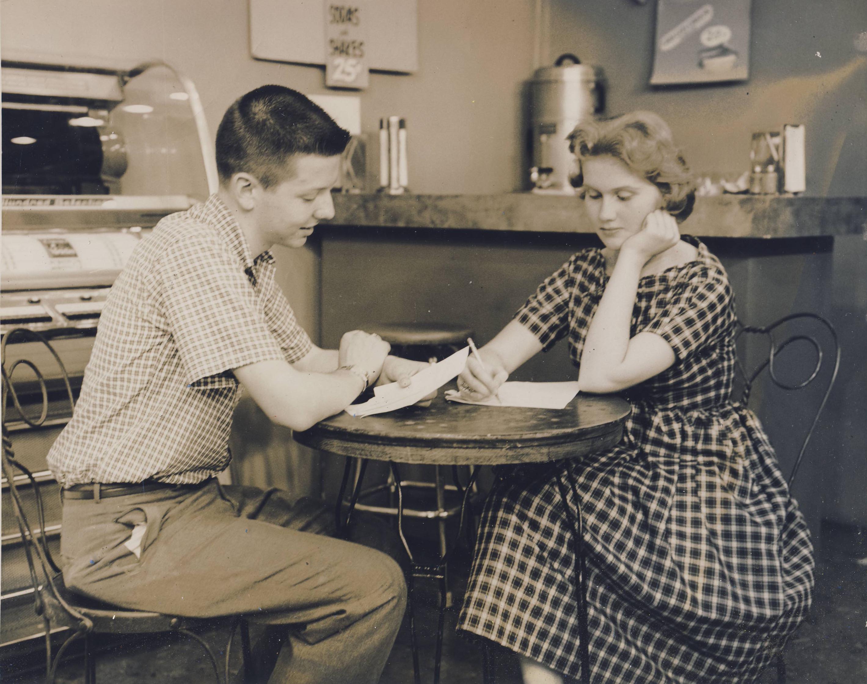 Some things never change–including people occupying tables without ordering any food or drinks!
E. A. Fuller Farm
The Clintonville Historical Society October 2017 monthly newsletter contained an interesting article about the land at the Clintonville Women’s Club by Mary Rodgers.
________
The Clintonville Woman’s Club: The Women Before the Clubhouse
by Mary Rodgers
I was asked to speak at an evening meeting of the Clintonville Woman’s Club. Specifically, I was asked to speak on the subject of the history of the land that the Clubhouse occupies. I have always understood that the Clubhouse was located on land from the old Fuller Farm. I was surprised to learn more about the “Fuller” family.
In the 1820s, John Rathbone sold farm lot 5 to Edward Amaziah Stanley. Using today’s landmarks, that land would have been bounded on the east by Indianola Avenue, on the west by the river, on the south by roughly Torrence Road and on the north by roughly Overbrook Drive. When Mr. Stanley died in 1862, his land holdings were passed down to his children. Harriet Marie Stanley (aka Hattie) was one of those children. She was born in Connecticut in 1831. Based on the extensive land holdings throughout Ohio, I believe her father Edward was an Ohio land speculator. After acquiring several thousand acres, in 1829, he returned to Connecticut to marry Abagail Talcott Hooker. Sometime between 1831 and 1834, the family moved to the Clintonville area.
In 1856, Hattie married Erskine Asa Fuller, aka E. A. Fuller. E. A. has known as a dealer in stock animals. When her father passed away, Hattie inherited all of farm lot 5 in Clinton Township Ohio. The 1870 census shows a large extended family living together in Clintonville. The Fullers and their daughters, Hattie’s mother, brother, sister and several farm hands and servants. The combined household value per that census was in excess of $25,000. Hattie passed away in 1879. E.A. passed away in 1894. After their deaths, the farm was transferred equally to the four Fuller daughters–Abby, Mary, Katherine and Martha. Martha Fuller and her sister Katherine Fuller Peters lived all of their lives in Clintonville. They owned two brick homes along High Street; Katherine’s was just south of where the Library sits today and Martha’s was where the Christian Science church sits today. Martha Fuller passed away in 1938. She left half of her land holdings to long time farm hand Matthew McCallen and half to her niece (sister Mary’s daughter) Helen Osborn. Eventually, all the land was sold off, some to the Christian Science Church, and some to the Calvary Bible Church and the balance to the City of Columbus. The lane where the Clintonville Woman’s Club land is located was purchased by the Kiwanis Club of Northern Columbus. That Club loaned the ladies the funds needed to build the Clubhouse. In turn, they held a mortgage on the property. The Woman’s Club members worked tirelessly and retire their debt to the Kiwanis within five short years! They have owned the Club house and property ever since.
Just Add Water
Here are some nice pix of the Olentangy Amusement Park’s swimming pool, without water. [Images Courtesy of Galen Gonser]
Looking South:

Looking East:

Looking Northwest:

As I write this, it’s easily 88 degrees and humid. I’d love to have access to an outdoor swimming pool right now…But one with water!
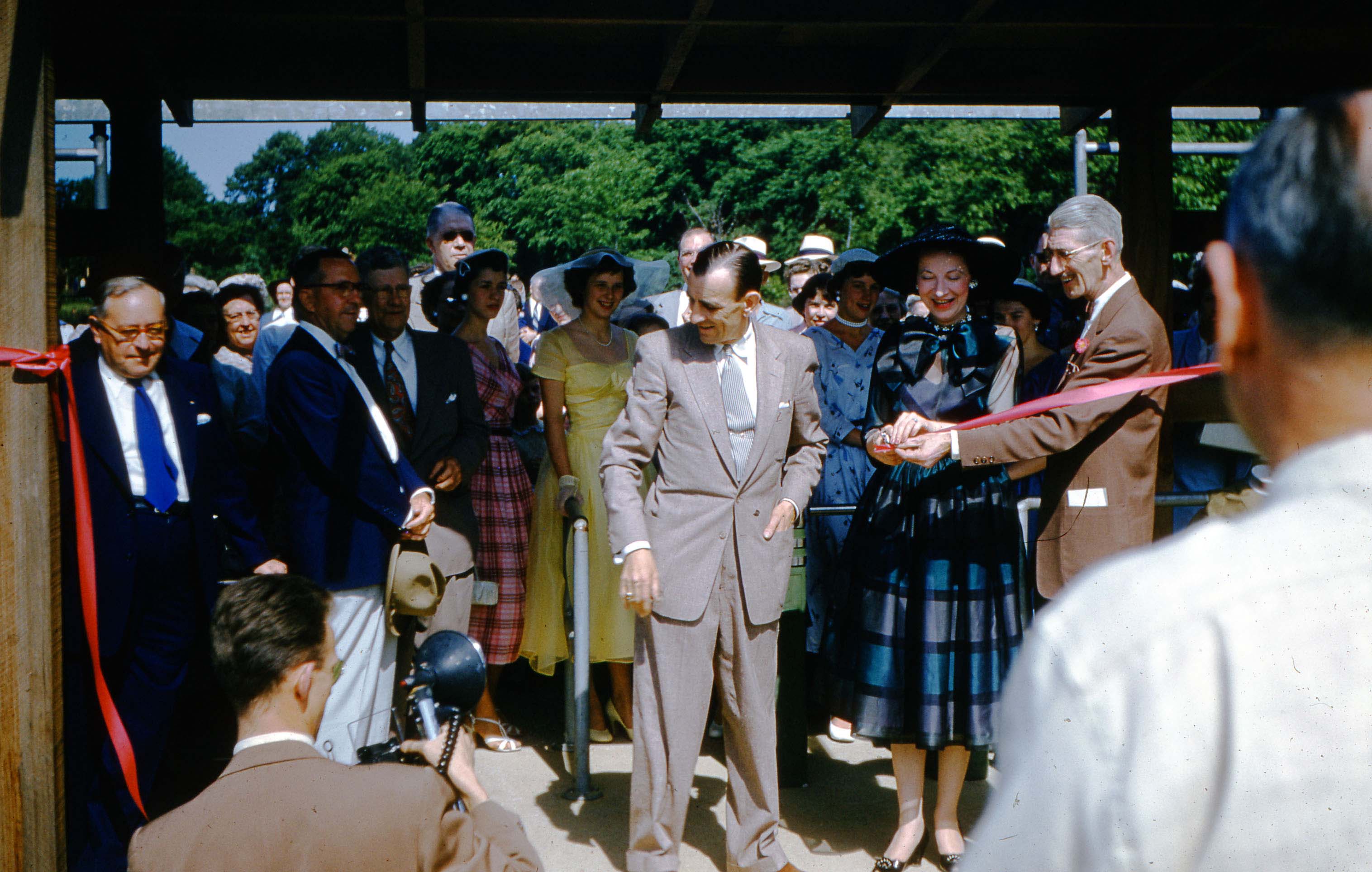
A Rose Is a Rose Is a Rose Is a Rose…
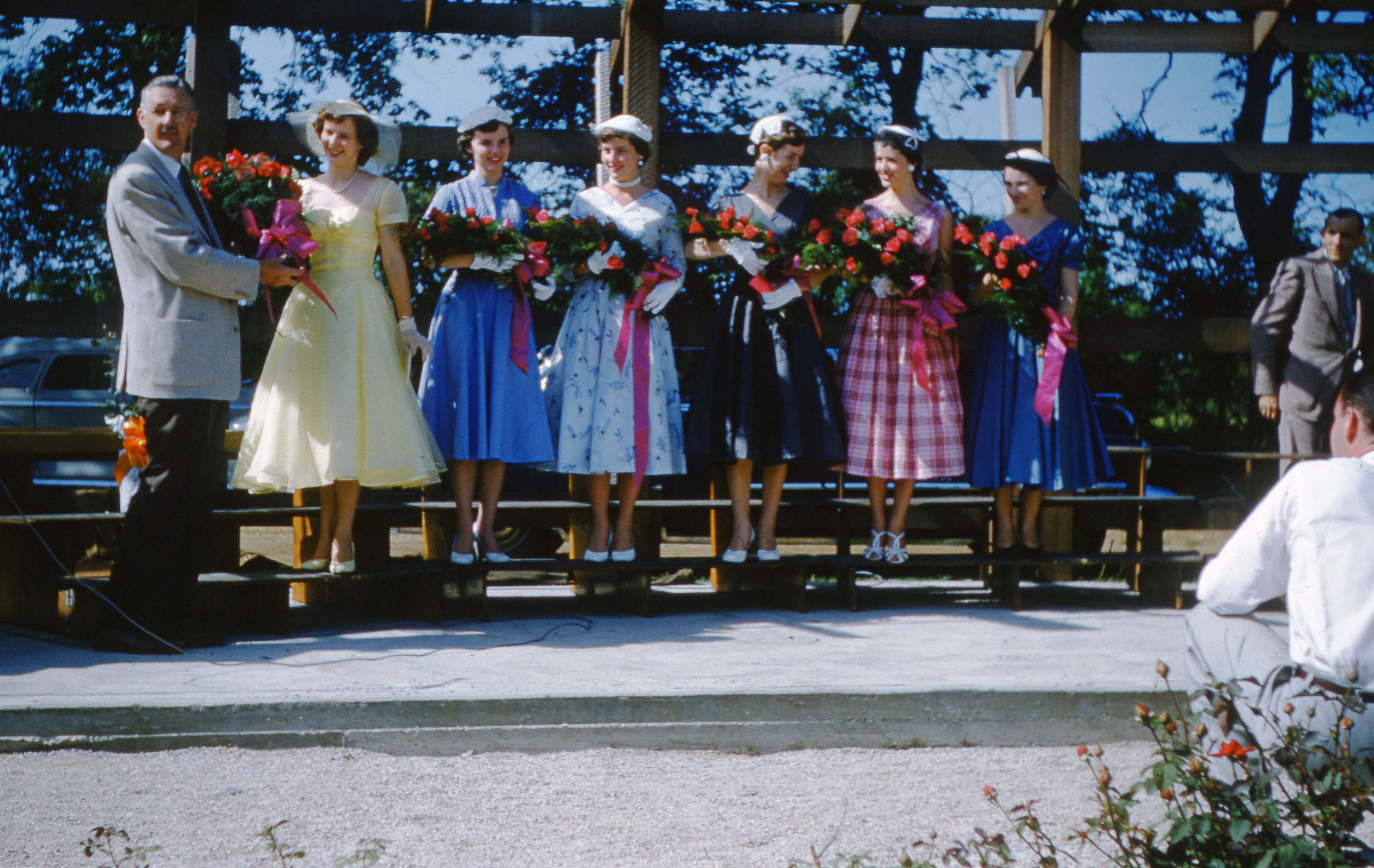
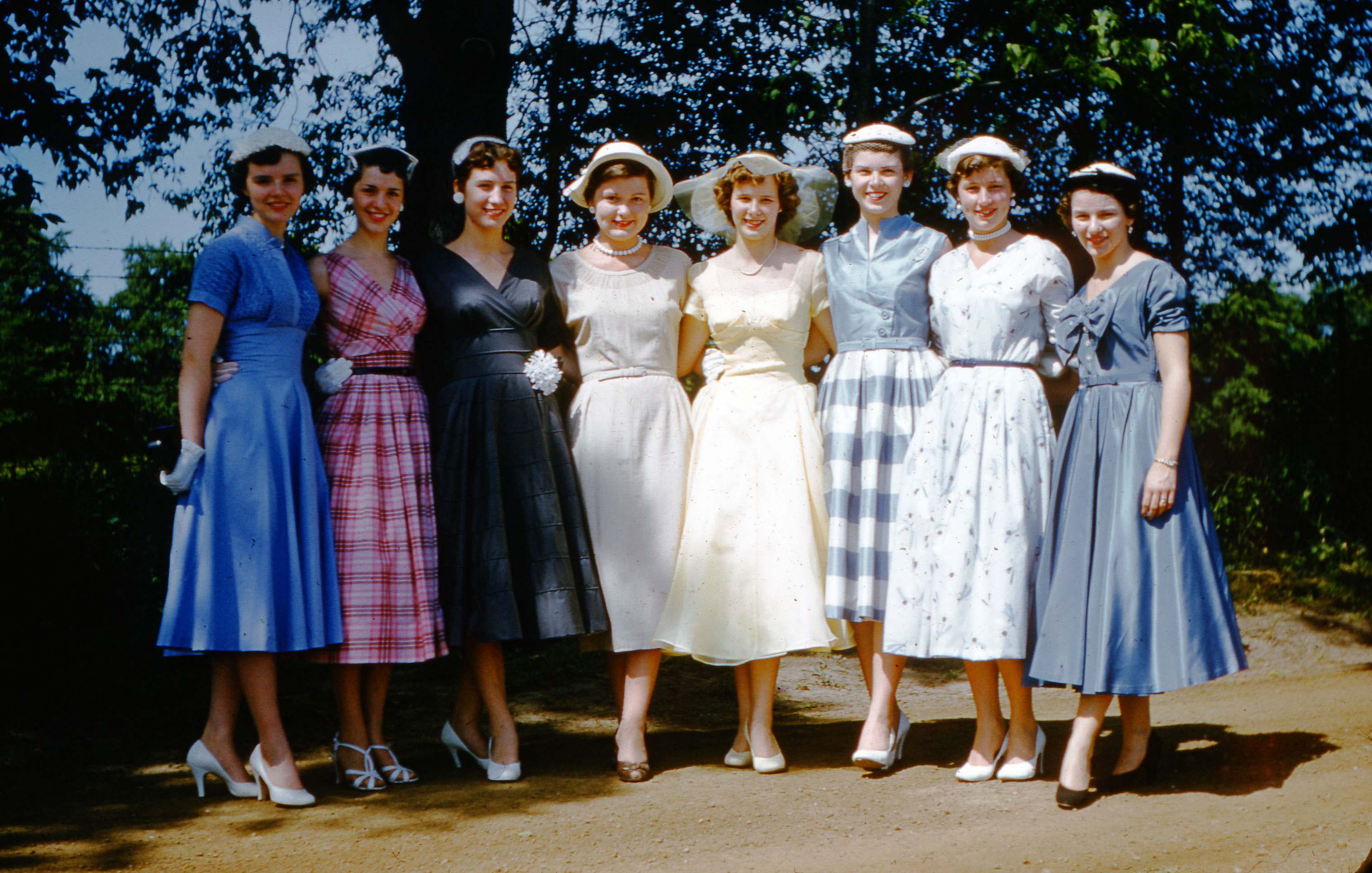
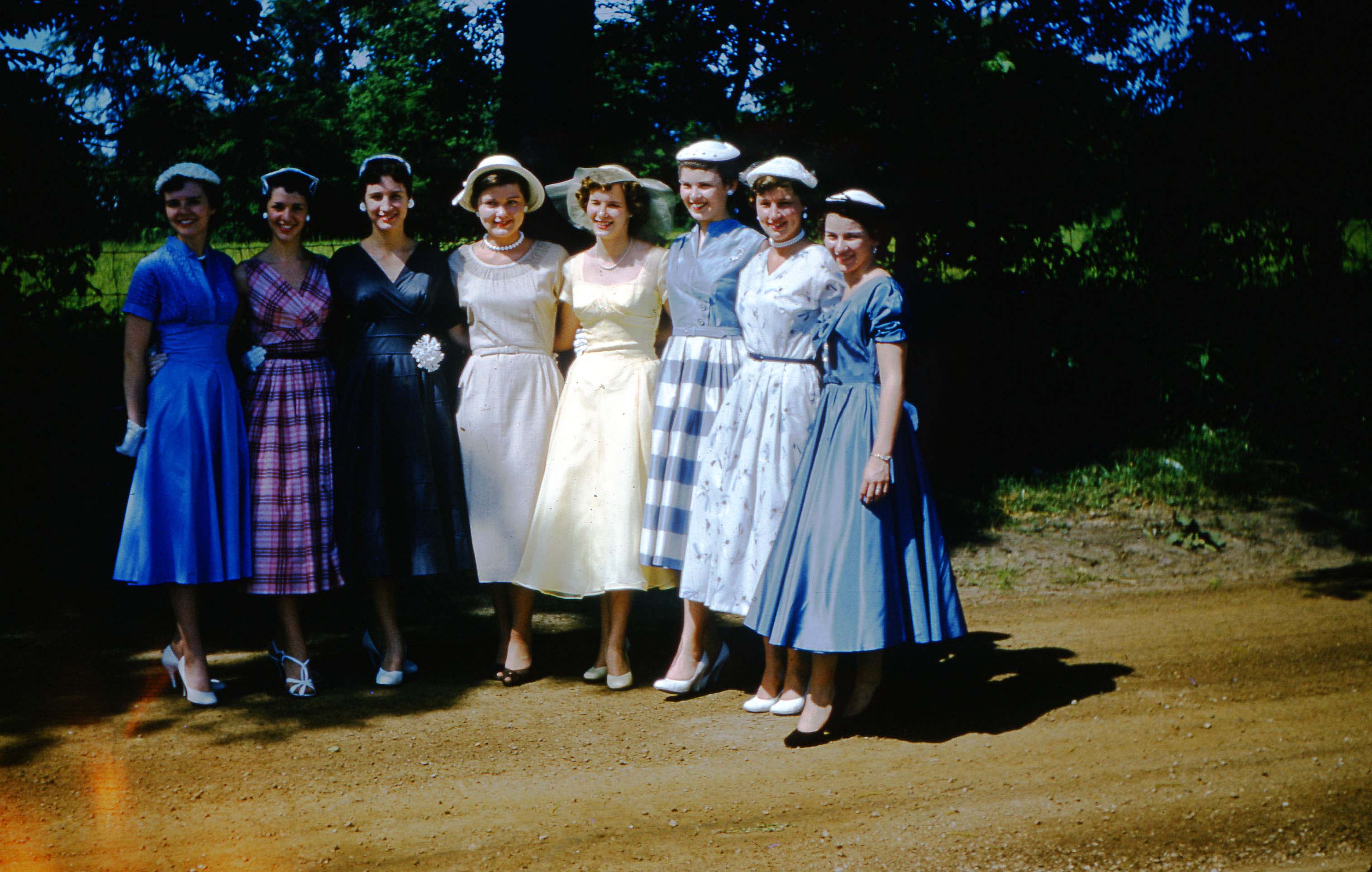
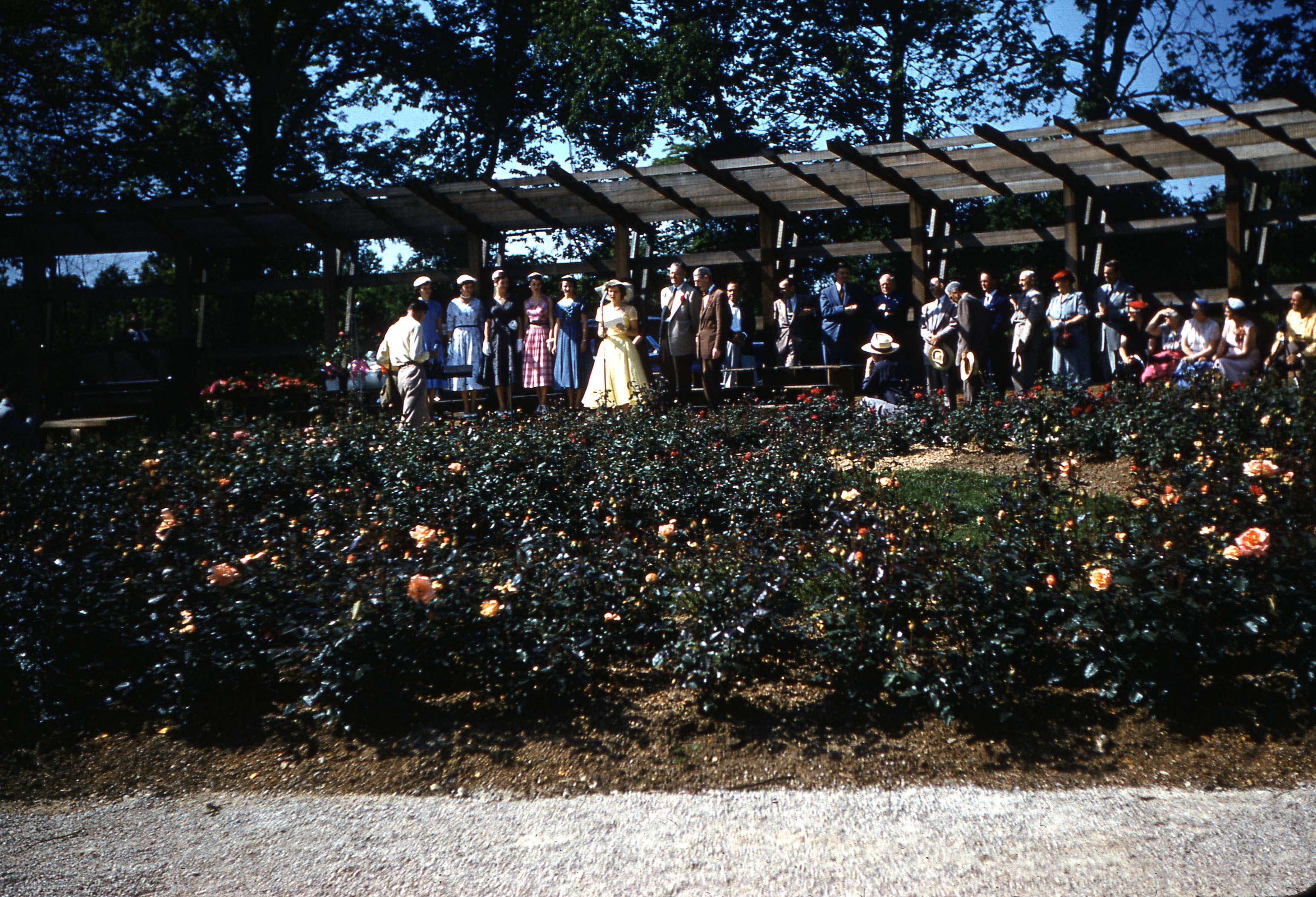
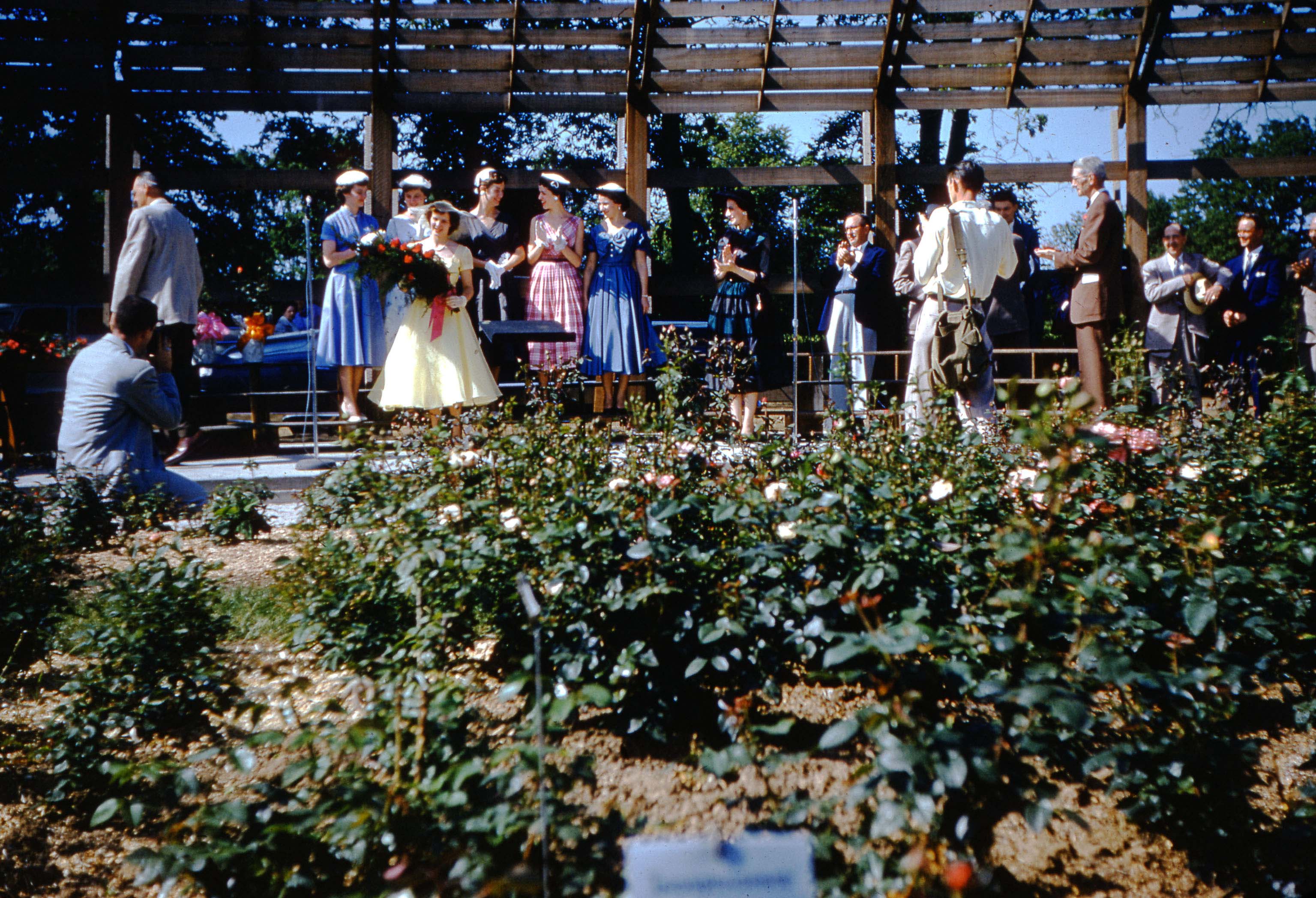
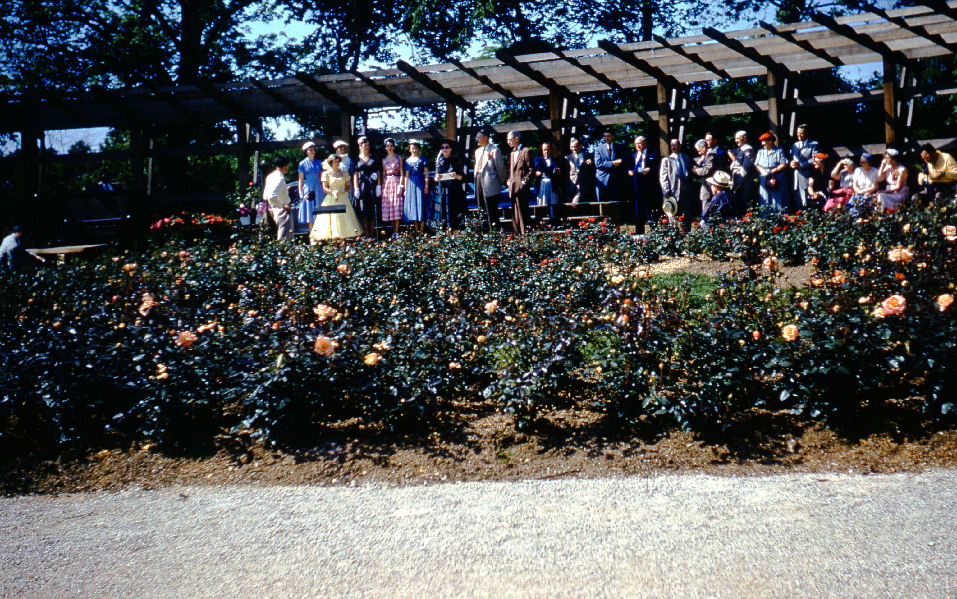
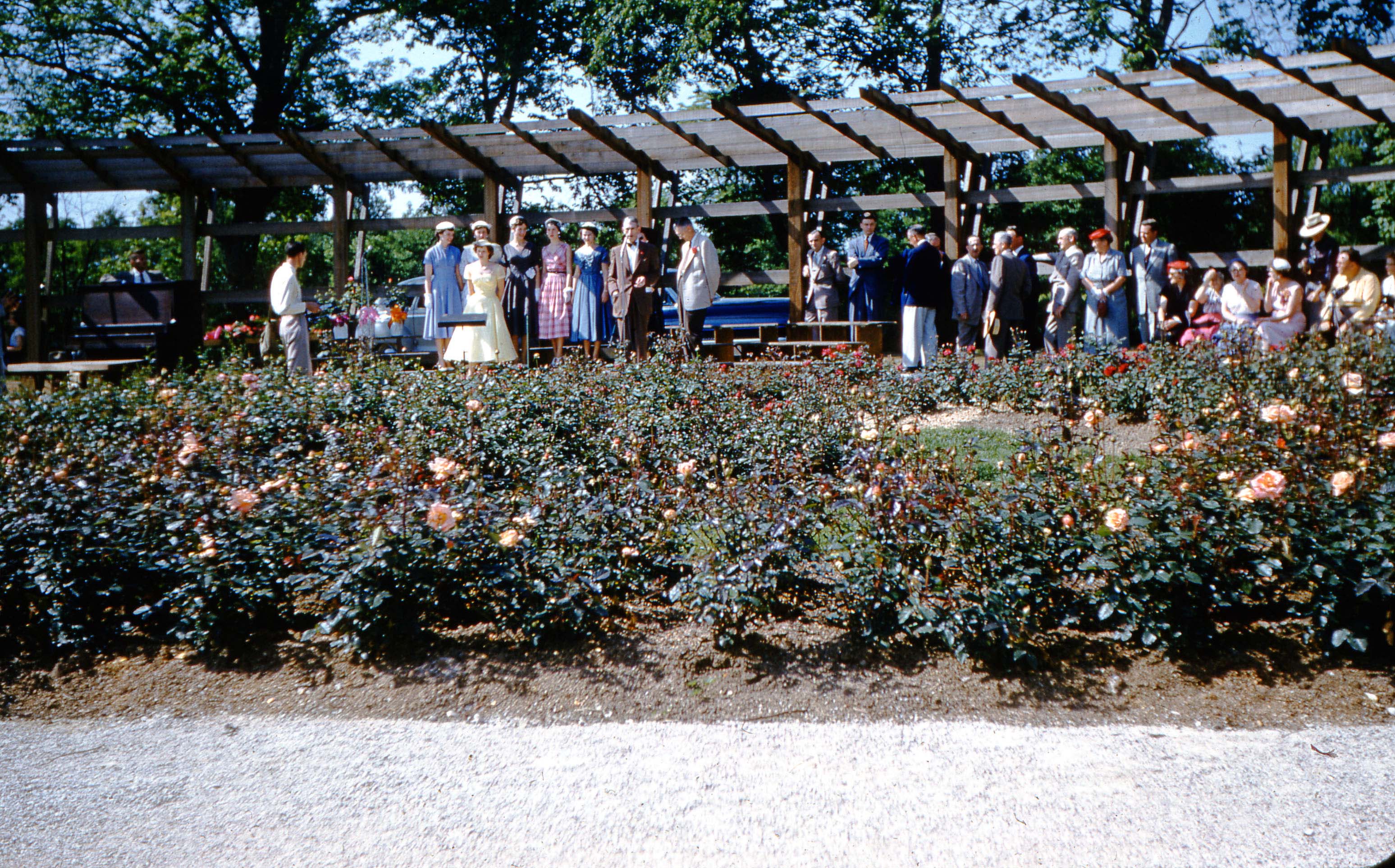
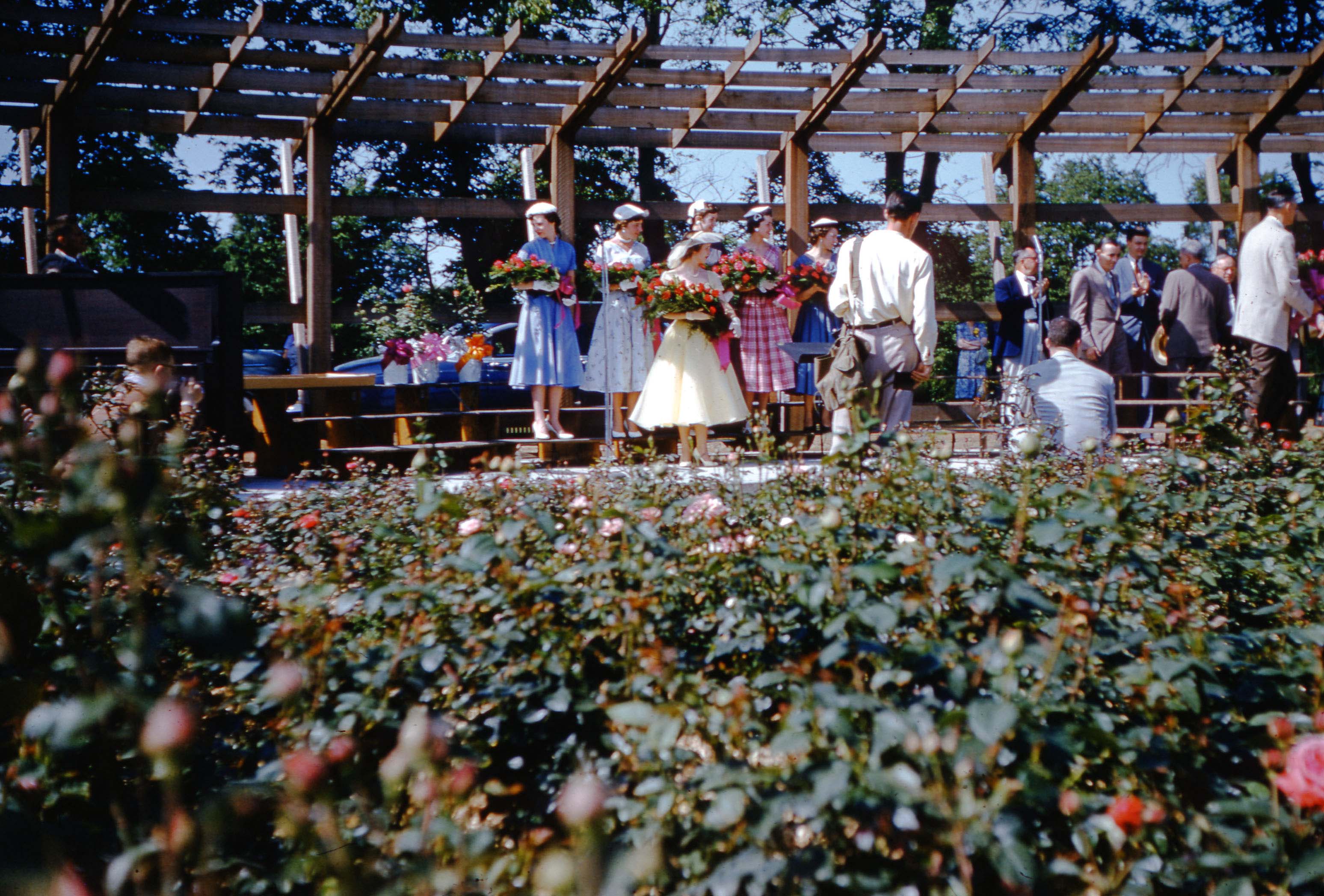
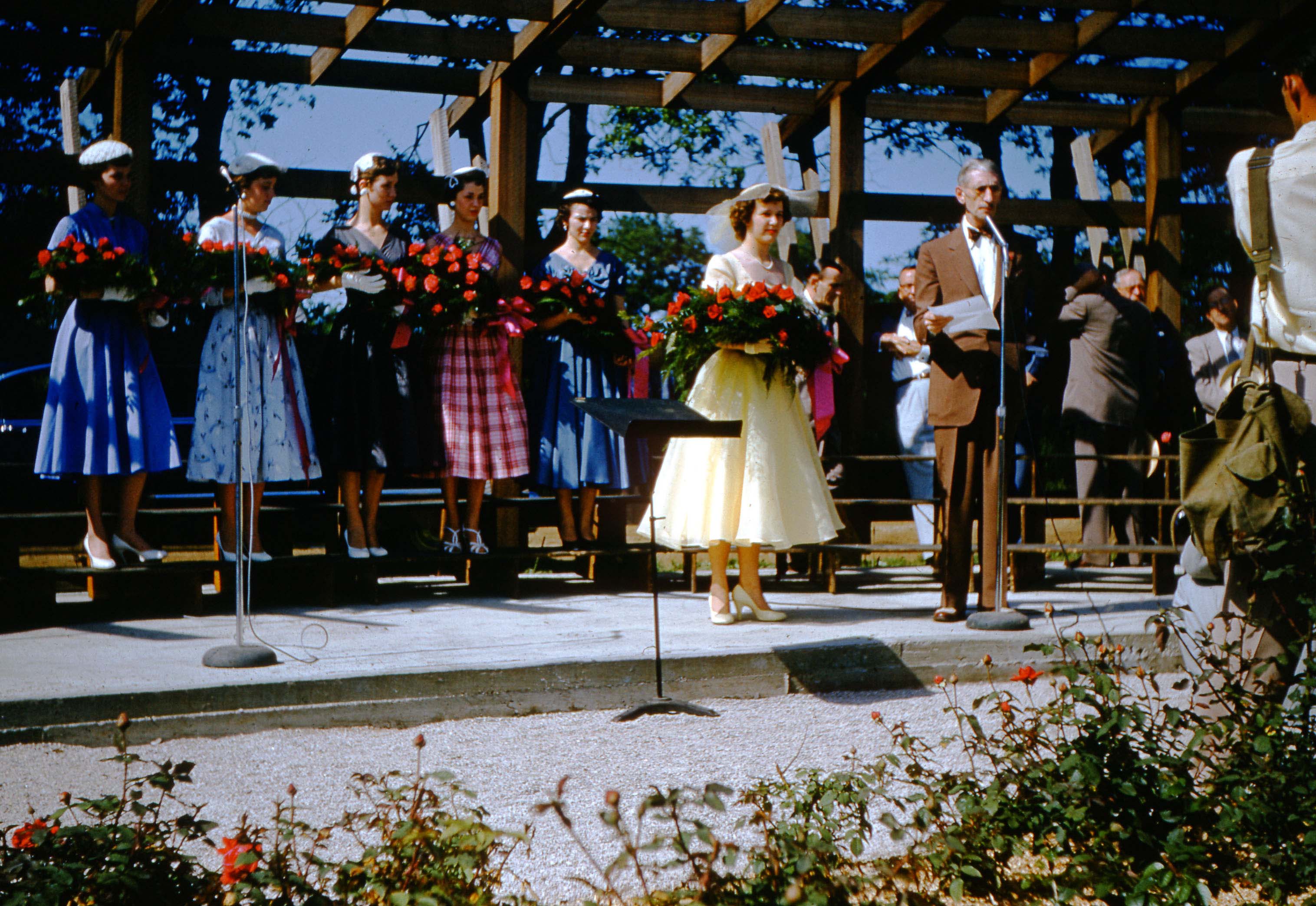 Joyce Ailes Schatz shared some wonderful Maiden of the Roses treasures with us. The photos were taken by her dad, Howard Ailes, on May 30, 1954, and they are of that year’s Maiden of the Roses pageant. The winner that year was Nancy Blanchard (later, Mrs. Clyde Graham). Nancy is Joyce’s cousin.
Nancy attended Mifflin High School, which in 1954 was a county school and located on Sunbury Road near Agler Road. Nancy was born April 23, 1938 in Columbus, and died May 10, 2018. [Images courtesy of Joyce Schatz]
You can read more about this pageant here.
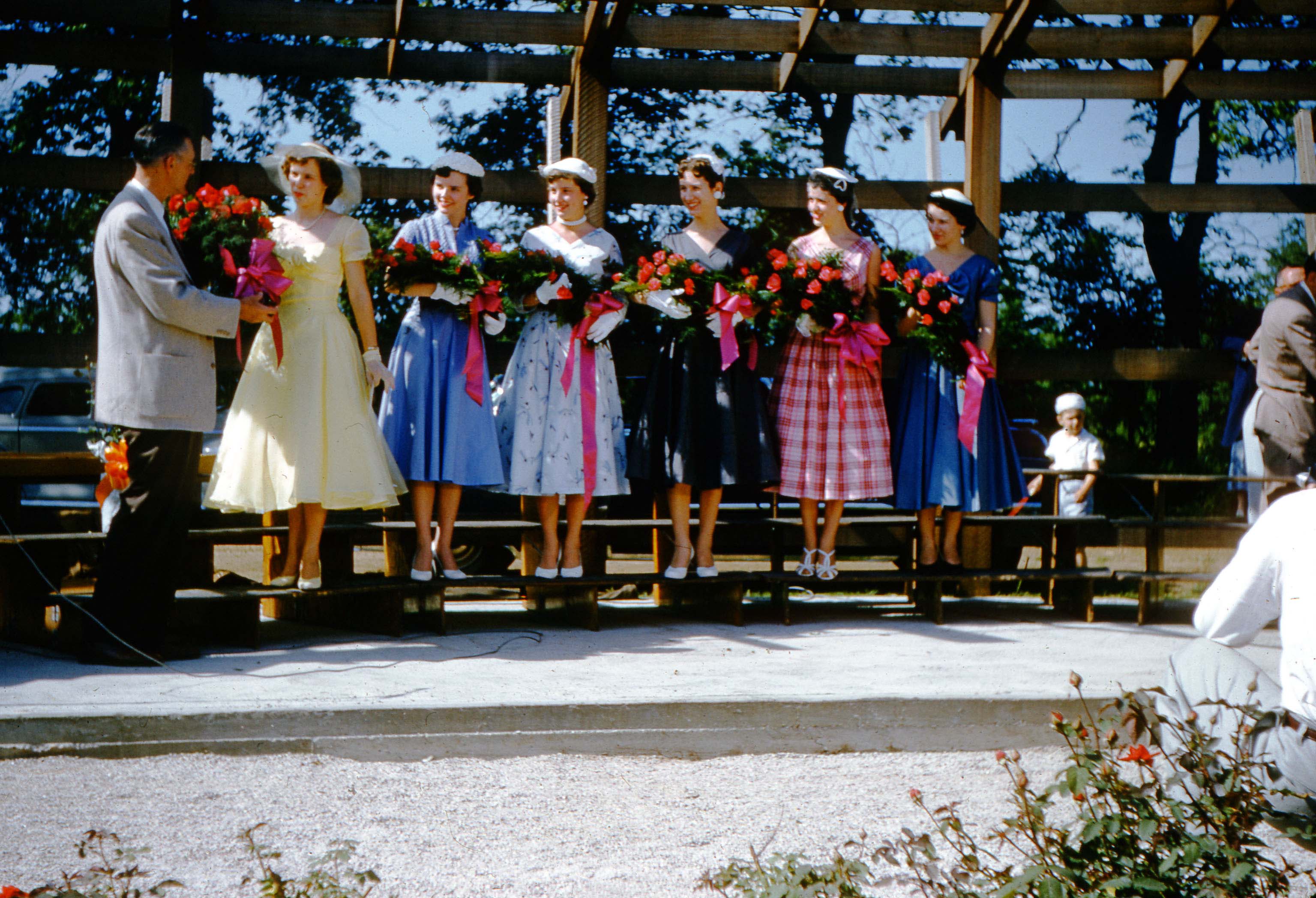 In these images, Queen Nancy is joined by her court, Ruthann Limotta, Carol Newhouse, Dorothy Corfee, Charlene McNair, & Louise Winzenreid (in unknown order). The court’s other member was Barbara Harder, but she does not appear in the picture. Does anyone know who the man is?
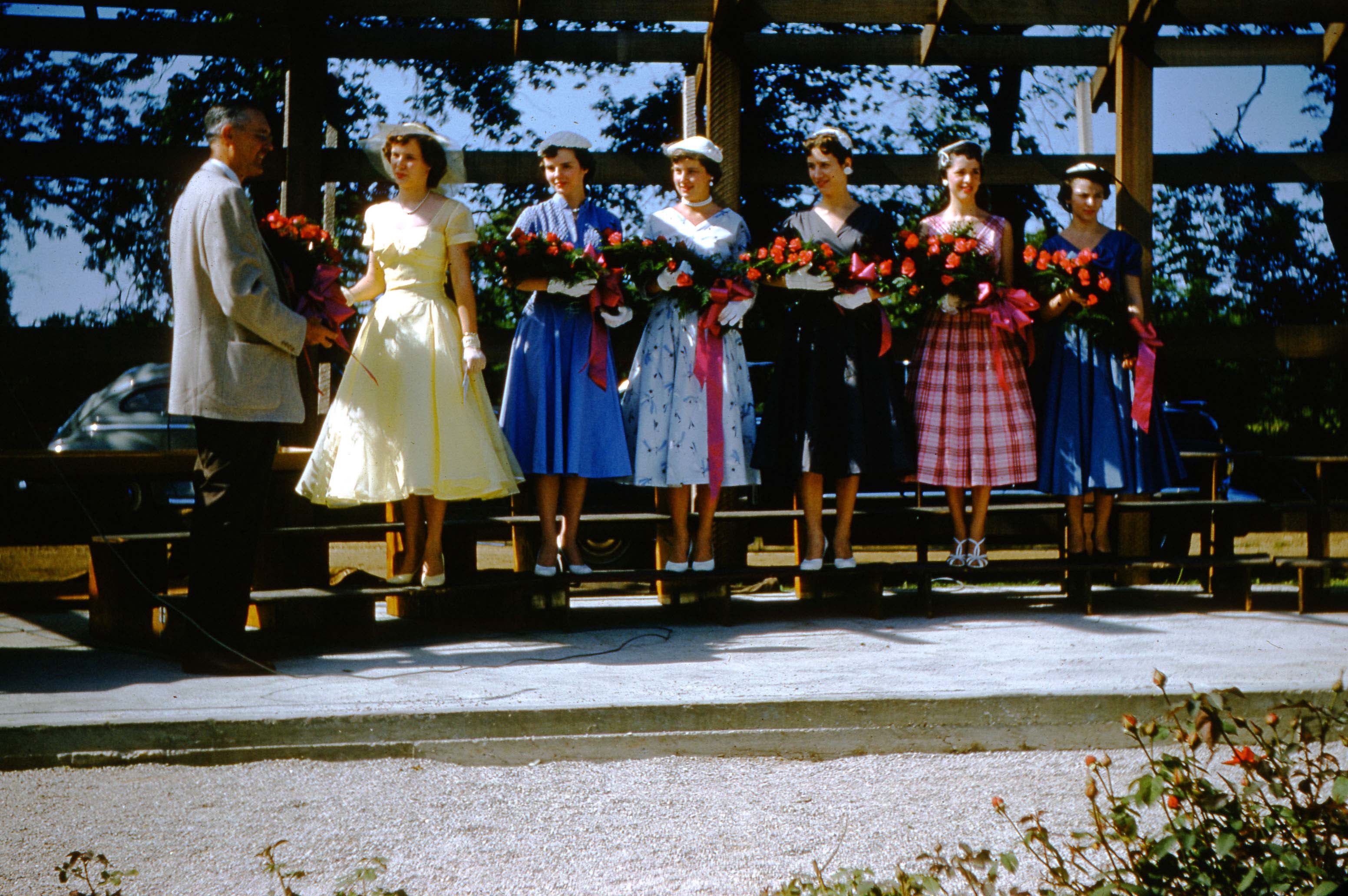
In the next two images of the queen and her court, we are not sure who the two extra women are.
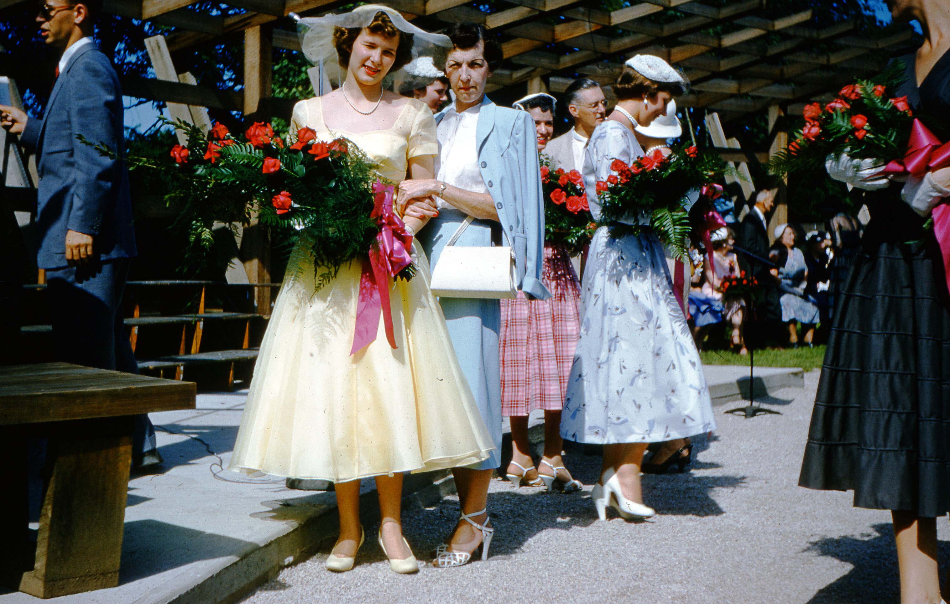 Nancy and her mother, Mrs. Bernice (Ailes) Blanchard. Bernice was the photographer’s sister.
In the next three images: Mayor of Columbus Jack Sensenbrenner, Mrs Jane Lausche (wife of Ohio Governor Frank Lausche), and Ray McNamara (Ohio Director of the American Rose Society)
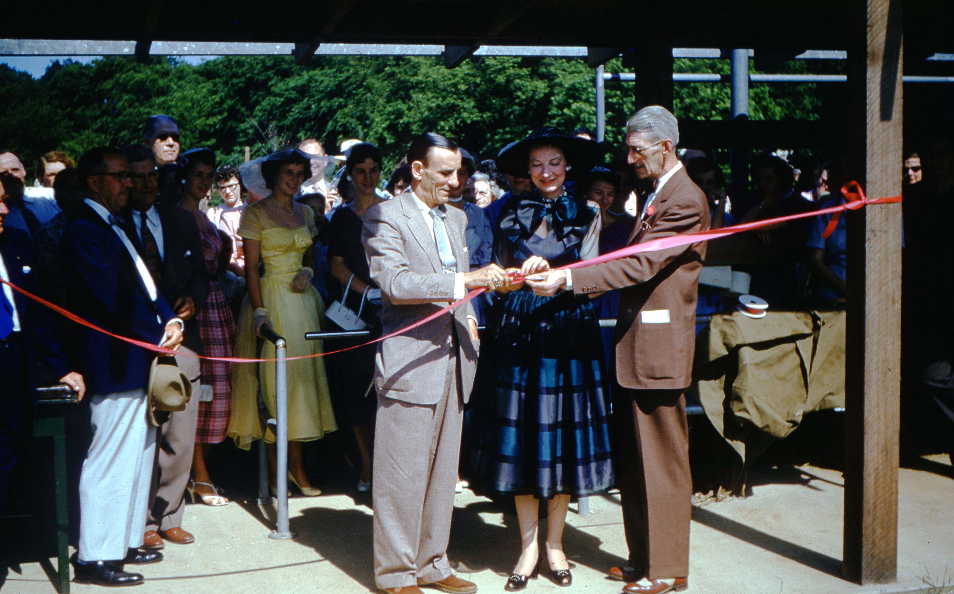
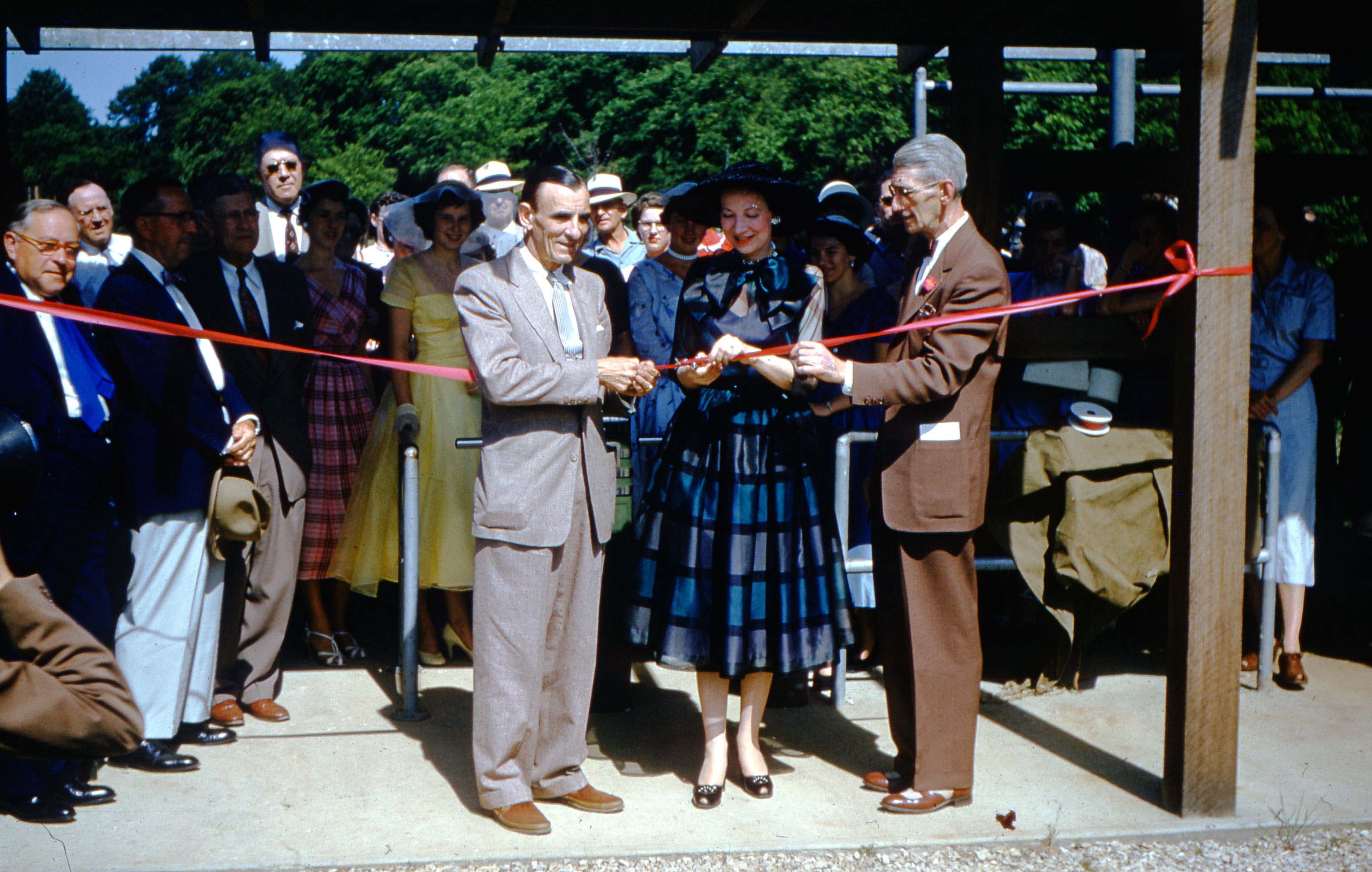
Nancy Blanchard and her court, and Ray McNamara, Ohio Director of the American Rose Society.
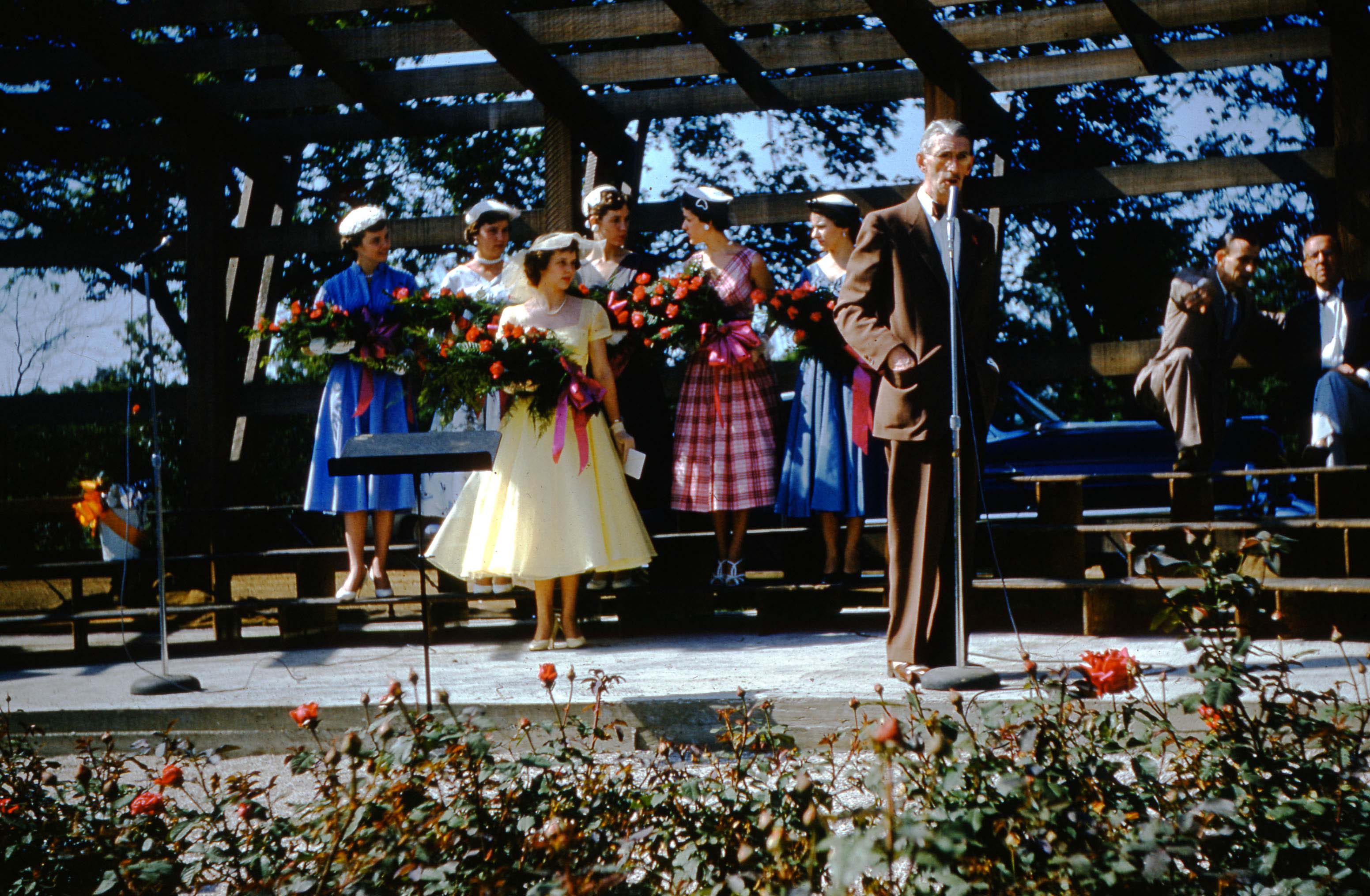
And a few more from Joyce’s treasure trove of pictures.
Smith’s Skating Rink
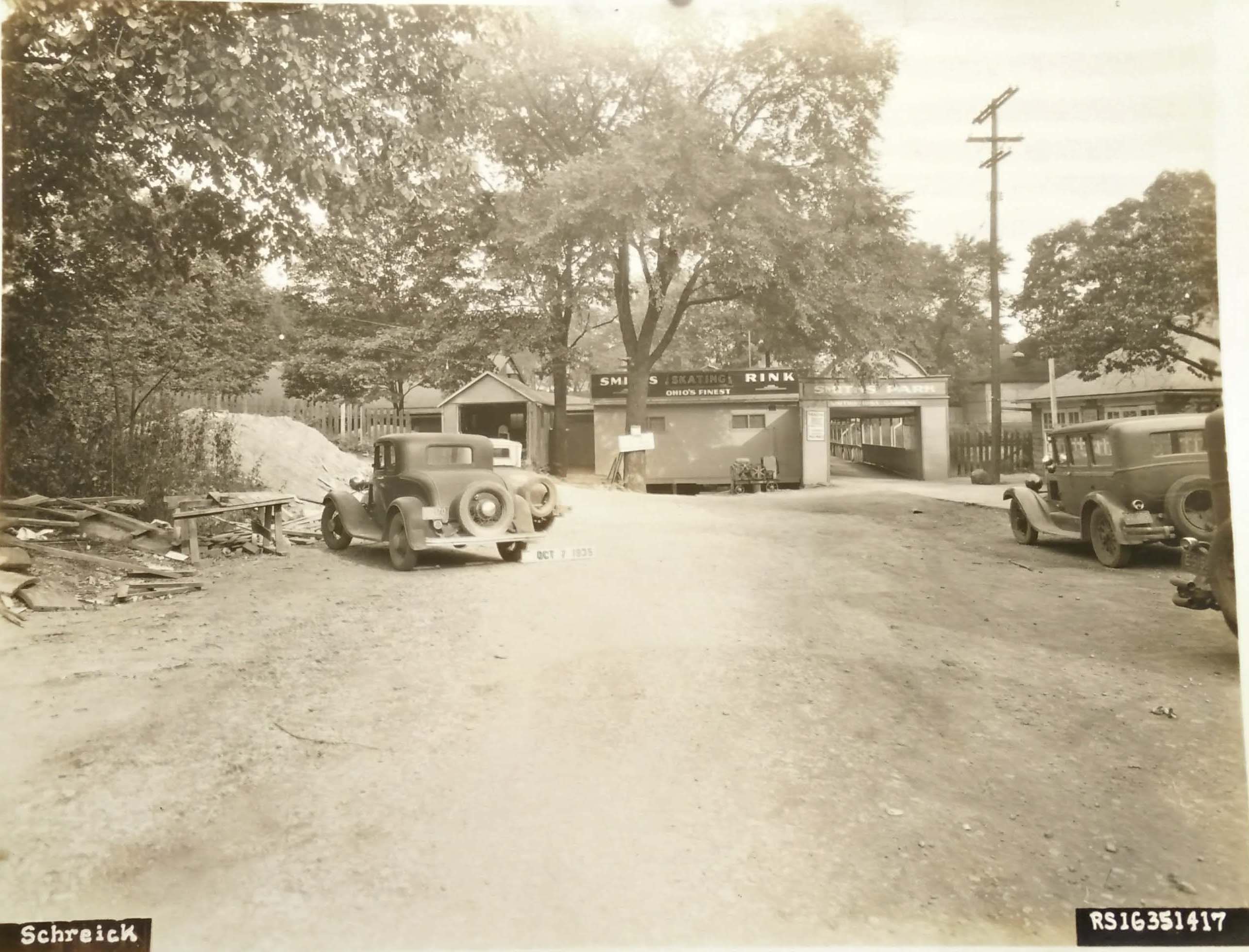 This is not Clintonville! But it is close enough that folks in the Clintonville neighborhood would surely have frequented it.
George W. Smith, a well-known Columbus dancing instructor, built Smith’s Iuka Dance Gardens around 1903. Two seasons later, Smith and his wife opened Smith’s Skating Rink, a roller skating rink.
Both establishments were located at 2150 North Fourth Street in Columbus, Ohio, until they closed in 1971.
George Willard Smith is interred in Greenlawn Abbey, and here is an excerpt about George and his wife Adele Green Smith from the Abbey’s web site:
[Image courtesy of Galen Gonser}Abbey resident George Willard Smith was known as the “King of the Outdoor Amusements” in the early days of the 20th century. He certainly didn’t start out that way. He was born on Christmas day, in 1860, in Syracuse, New York. His parents, John and Fannie Smith, were hard working blue collar kind of people. The family would make their way to Columbus in 1872 and John would find a job as a salesman. (The directories of the time list him as a “peddler”.) A few years later around 1875, George would join in with his father to help with rent and bills and they both would be carriage trimmers by the late 1870’s. Carriage trimmers were responsible for upholstering the seats, floors and roofs of buggies, and the Columbus Buggy Company was a large manufacturer in the city, employing well over 1,000 people by 1880. Work was so efficient, that they finished a buggy every 8 minutes on average. John would pass away in early 1882 at the age of 50, and which must’ve struck a chord in 22 year old George, with him not wanting to die young laboring away like his father did. It’s clear that George had another plan in mind. In those days it was very common to learn dance instruction by reading a book, as private lessons were expensive. Society minded people were getting waltz lessons and trying to be more genteel. George never spoke of any dance schools he attended, so the likely explanation as to how he learned and then taught dancing lessons was he got one of these books as well. (“The Universal Dancing Master,” written by Lucien Carpenter, was popular book published in the same year of John Smith’s death.) Although he was listed as still being a carriage trimmer until 1893, George started a “Home Academy of Dance” in 1894, giving himself the title of professor and calling himself a dancing master.
It’s not known how long Smith was courting Adele Green, daughter of William J. Green, a local Columbus physician. It’s possible that Adele, born in Knox county in 1880, was a student of George’s and he took a shine to her. George was 40 in 1900, Adele was 20, and they both shared an interest in dancing. It could also be that her father was a member of the Benevolent and Protective Order of the Elks, just like George was, and they were introduced to each other through that. Smith wasn’t an old man by any means, and even though it may look a little odd today, marrying a man many years older than her was a normal thing for a woman to do then. The age difference didn’t seem to matter to them much and they were married in 1902.
Smith actually had an article in the Columbus Dispatch claiming that he taught 26,000 people how to dance, and that he was going to officially retire from teaching his home dancing classes. He would still own them for several years, but would employ instructors. His big break was that he was able to lease some land from the Neil family in the area of Iuka Ravine where Northwood and 4th is today for a dance pavilion. A few years later, in 1905, there would also be a roller skating rink on the same property, which George named “Smith’s Iuka Park Gardens.” Roller skating competitions would be held in the rink, where the best skaters in the state would compete to see who could skate the fastest laps.1909 was the biggest year for such a competition.
George had enough money by this time to own and operate the B. F. Keith Theater on Gay Street, a vaudeville theater. His in laws lived in an apartment on the floors above the theater itself, and that’s also where Smith had his office…
As the teens waned and the 20’s came roaring, George and Adele would do less with the theater work and spend more time on their more profitable dance hall and skating rink ventures. Iuka Park Gardens became an institution for the community, even employing boys as young as 12 years old to help lace up the skate to the shoes of the patrons. Several people would meet their sweethearts for the first time at the rink, get their first kisses, and engagements there over the years. The Smith’s employees loved them and some would stay employed by them for decades. George’s brother in law Ivan would help run the business in 1938, and George would pass away in 1948. Adele would continue Iuka Park Gardens until her death in 1965, and it would remain open until Ivan had to close the business in 1971. The land was sold, the dance hall and rinks bulldozed, and the Iuka Park Commons apartments are there to this day. The Smiths had no children.
Tigers & Lions & Bears! Oh My!
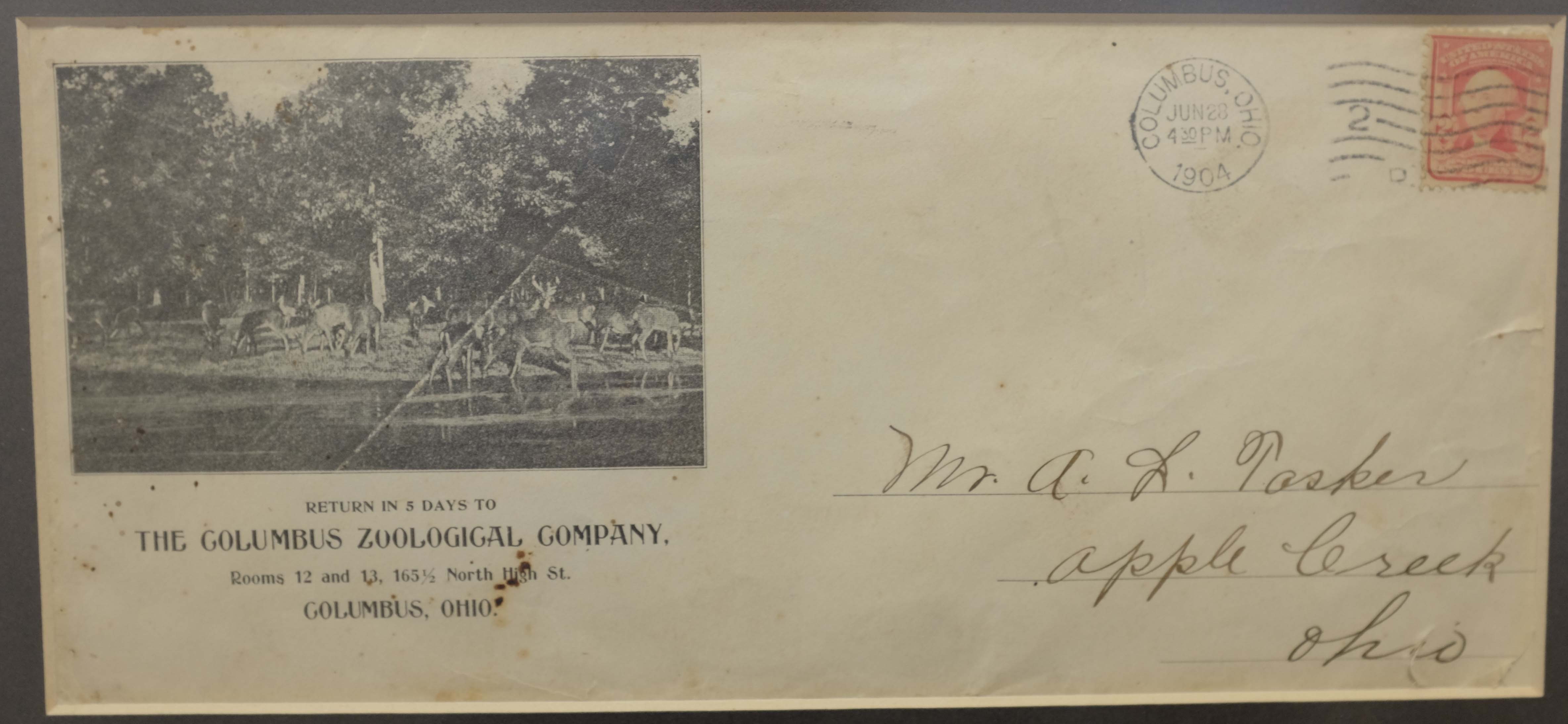
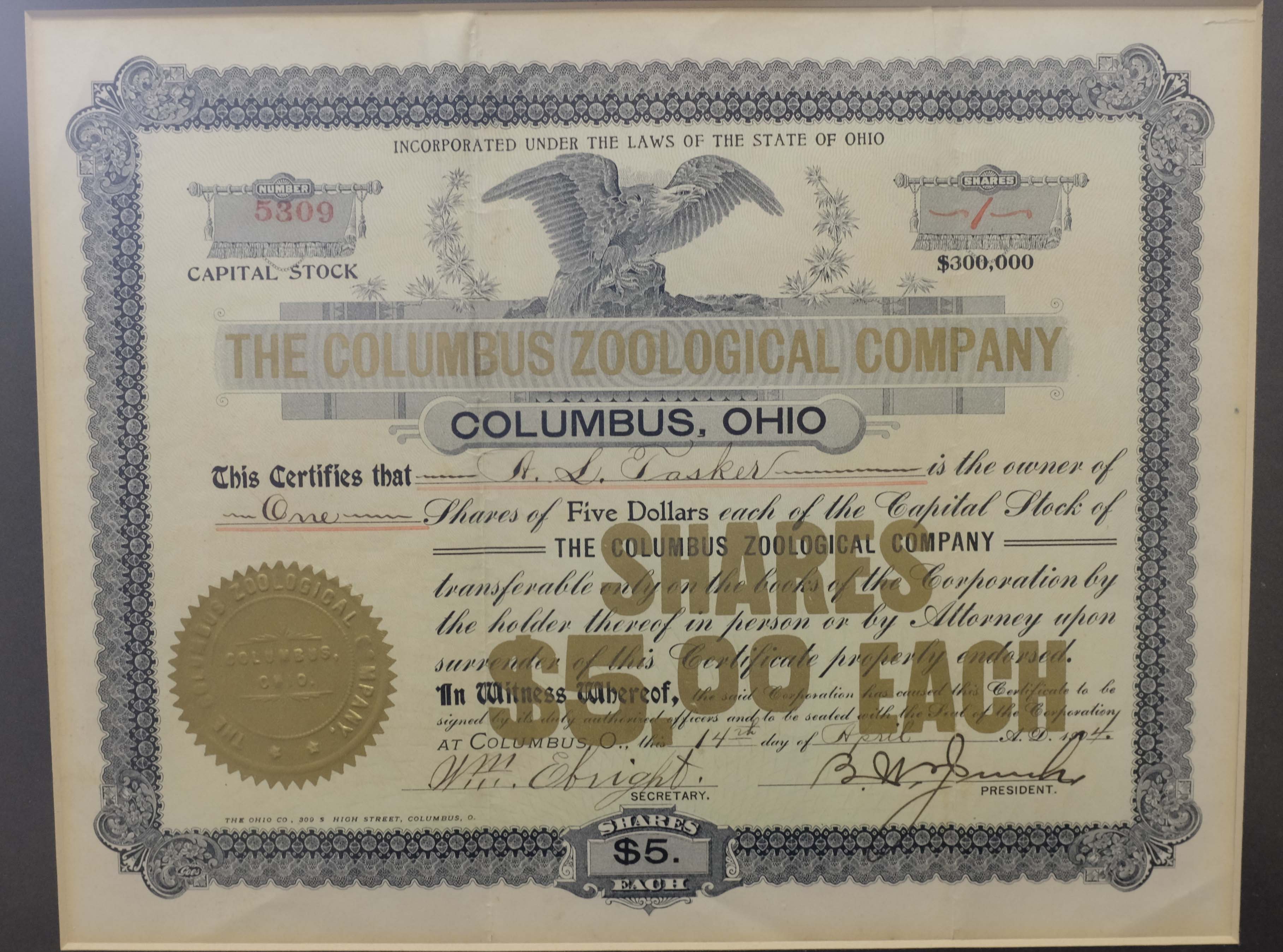
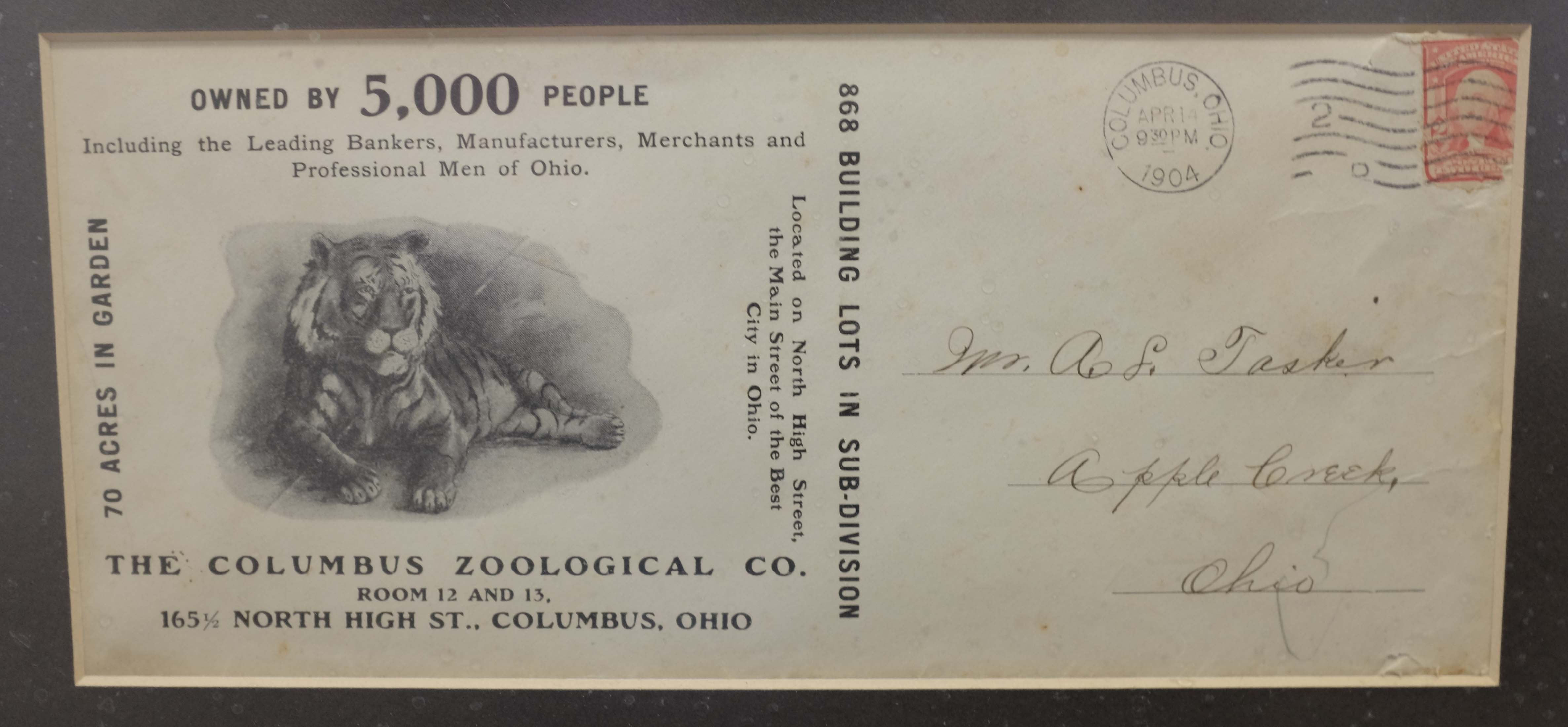
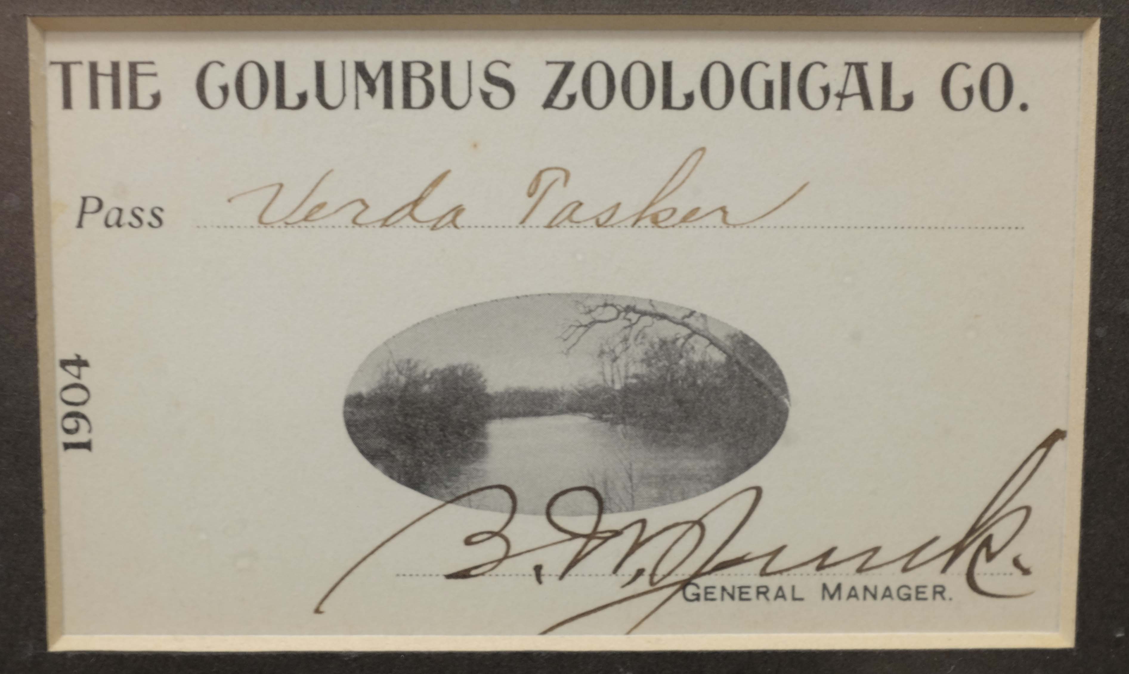
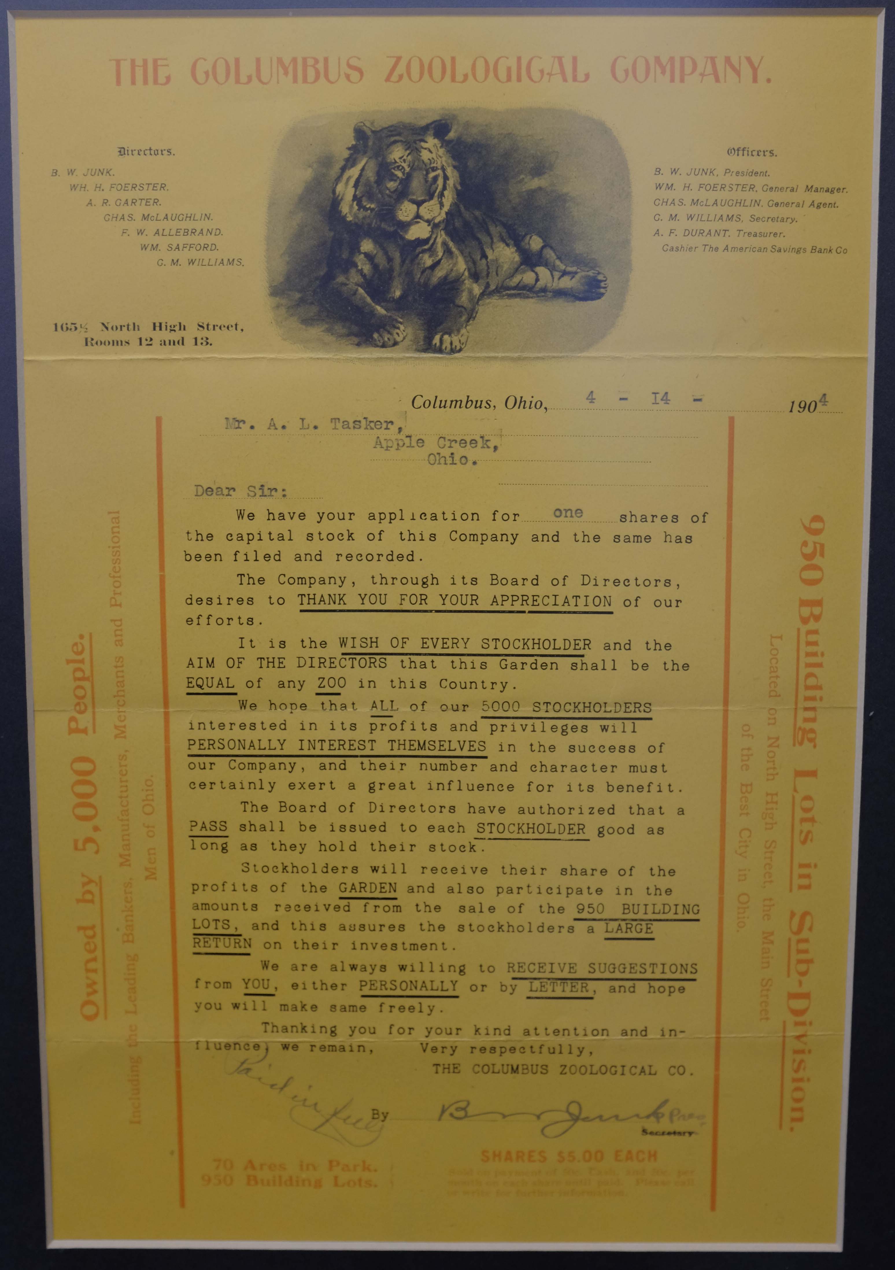
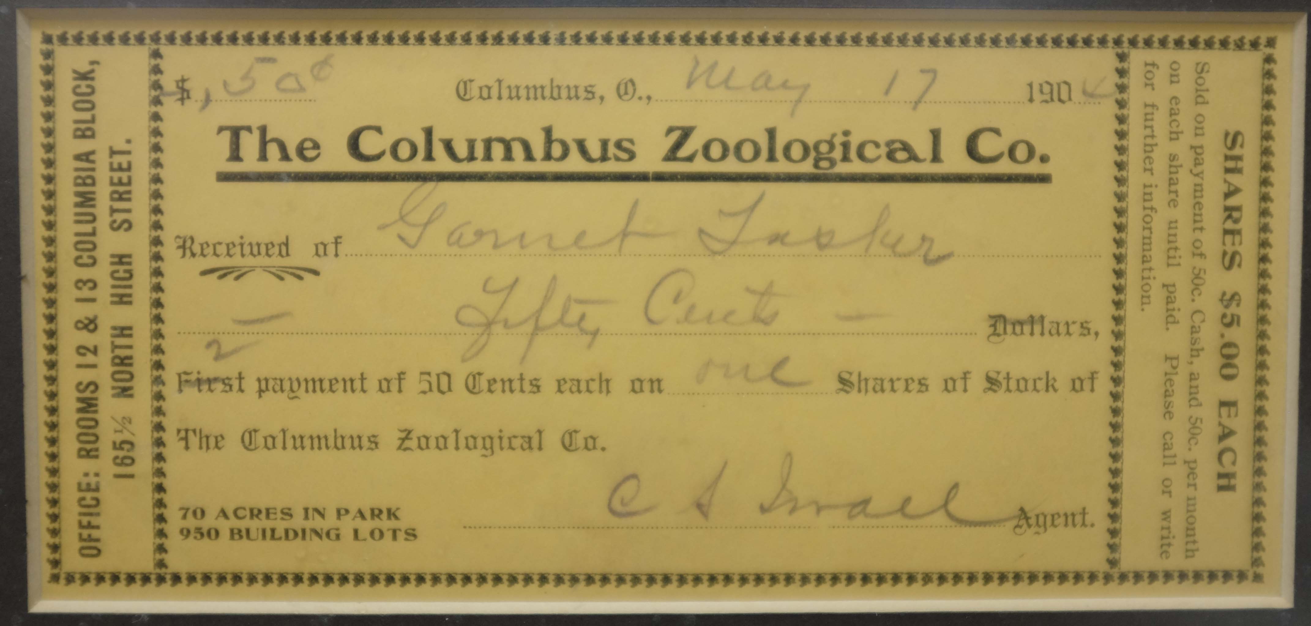
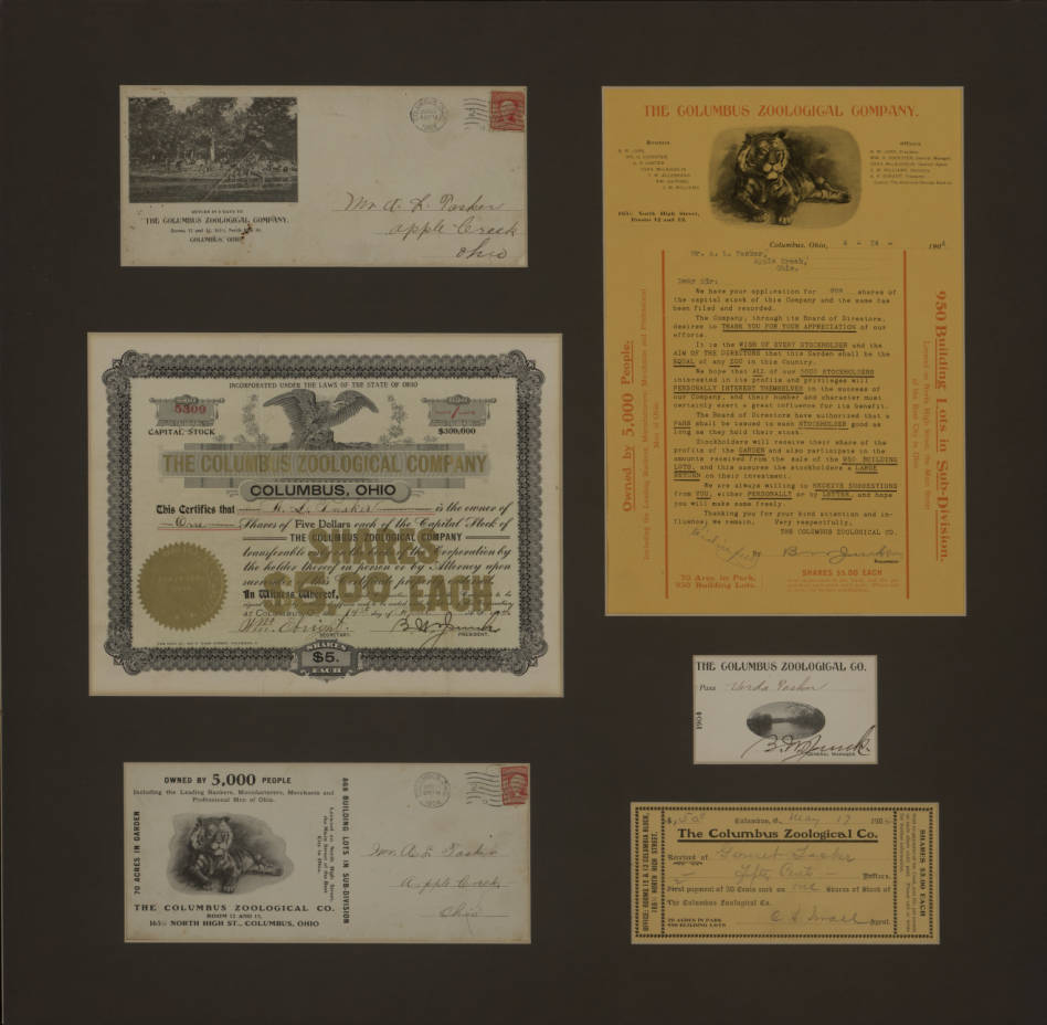 Wow-Alex D. Stanek has located some treasure! The Columbus Zoological Park was located south of Morse/Rathbone Road on the west side of High Street. The east side of High was the “Garden” which was divided into building lots. That neighborhood retains the name “Zooland”. The Zoo was established on land originally owned by John Rathbone. Rathbone died in 1853. That is when the land officially transferred to his daughter Eliza Wetmore and her heirs. Some of these documents feature a tiger. Prior research on the zoo revealed the existence of a meat eater in the animal collection but we’ve always assumed it to be a lion. One photo features a herd of white tail deer. Other animals included rattle snakes, a couple bear cubs, elk, and monkey imported from the Hagenbeck Zoo in Germany. Fabulous finds. [Text courtesy of the Clintonville Historical Society’s Newsletter. Pix courtesy of Alex D. Stranek and the Columbus Metropolitan Library.]
I Scream, You Scream, We All Scream For Ice Cream!
 I wonder how many ice cream stands Clintonville has hosted over the years? Surely this one at Olentangy Amusement Park was among the earliest.
We’re Going to the Zoo Zoo Zoo…
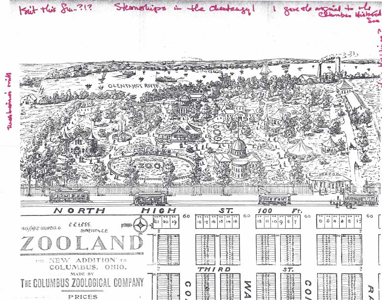 A great picture of the (Beechwold) zoo and partial image of the plat of Zooland, the subdivision on the west side of North High Street. Click on the image to enlarge it.
Steamships in the Olentangy! I guess the zoo picture was mostly, well, aspirational. Rumor has it that the Zooland housing lots were developed to raise funds for the zoo. You can read more about the zoo on my web site here. [Image courtesy of Wendy Bayer]
Moseying with Rick Pfeiffer through Clintonville
 Columbus City Attorney Rick Pfeiffer, who grew up in Clintonville, does a wonderful job giving an informal tour of the Clintonville community. (He has done this for the other neighborhoods of Columbus as well!) Thanks Rick! and we wish you well in your 2017 retirement.
Part One: https://bit.ly/CMosey1
Part Two: https://bit.ly/CMosey2
Two Theatres
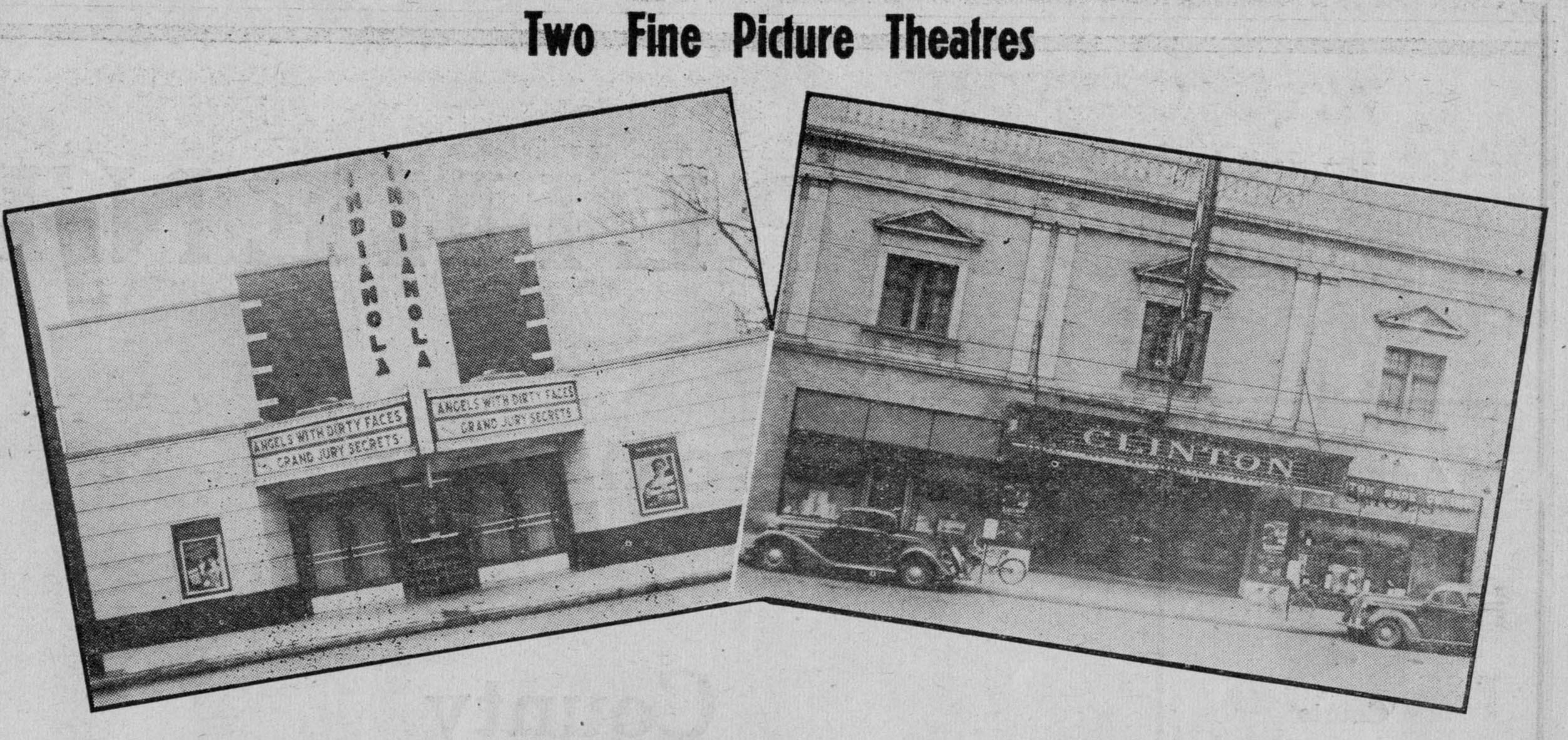 Nice images of Indianola Theatre and Clinton Theatre. The Indianola Theatre (now called Studio 35) was an independent theatre from the get-go; it opened at 3055 Indianola Avenue on February 17, 1938.
The Neth Clinton Theatre opened January 1, 1925 at 3379 North High Street.
Indian Springs & Wyandot Golf Courses–Aerial
 I’ve received several inquiries about whether I’ve ever encountered a map of the Indian Springs Golf Course. I haven’t, but would be interested in posting a digital copy of one on this web site.
Any former caddies out there with maps or golf course photos?
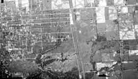
Bill Case, golf-course historian, sent me this 1938 aerial photograph of the land that is Wyandot Golf Club (top left corner, under the “1938”; you can see the ravine bisecting the course) and Indian Springs Golf Course is in the bottom left corner.
Bill says, “The attached is an aerial photo of Wyandot Country Club that I obtained from the county auditor’s office. The course is a couple of inches [i.e. inches on the original photo] directly below the June 15, 1938 notation on the photo. If you zoom in, you can make out pretty good detail of the holes. Morse Road is the lowest (or southern) boundary of the property. The driveway that winds its way straight north from Morse and then curves right or east toward the clubhouse is still there in use at the Deaf School. The trees and ravine divided the two area of the golf course.”
Between 1937 and 1980, the U.S. government–typically the USGS, BLM, or military–regularly took these aerial photos. They are impressively high resolution and lots of historic land-use information can be gleened from them. Original paper copies are available at the Office of the Franklin County Engineers, the Franklin County Auditor, and elsewhere.
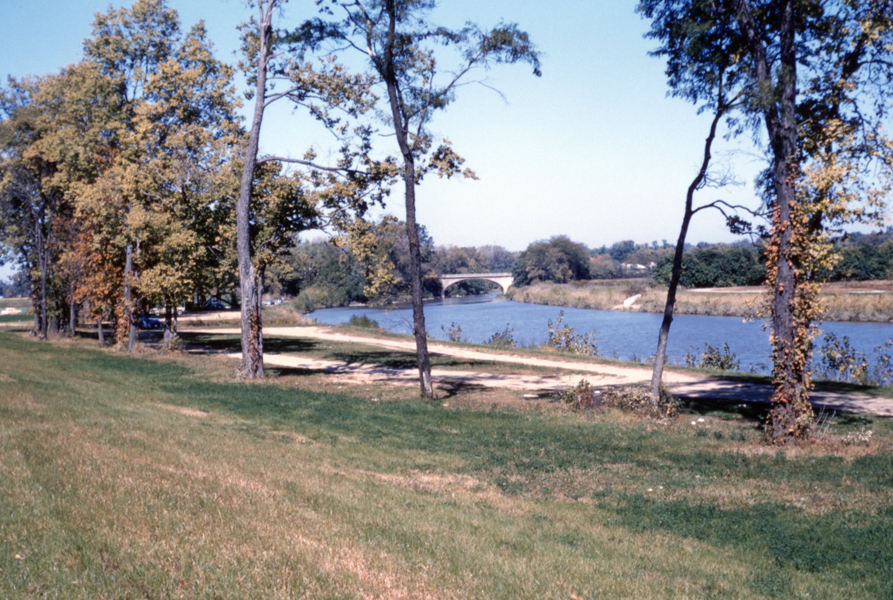
The River
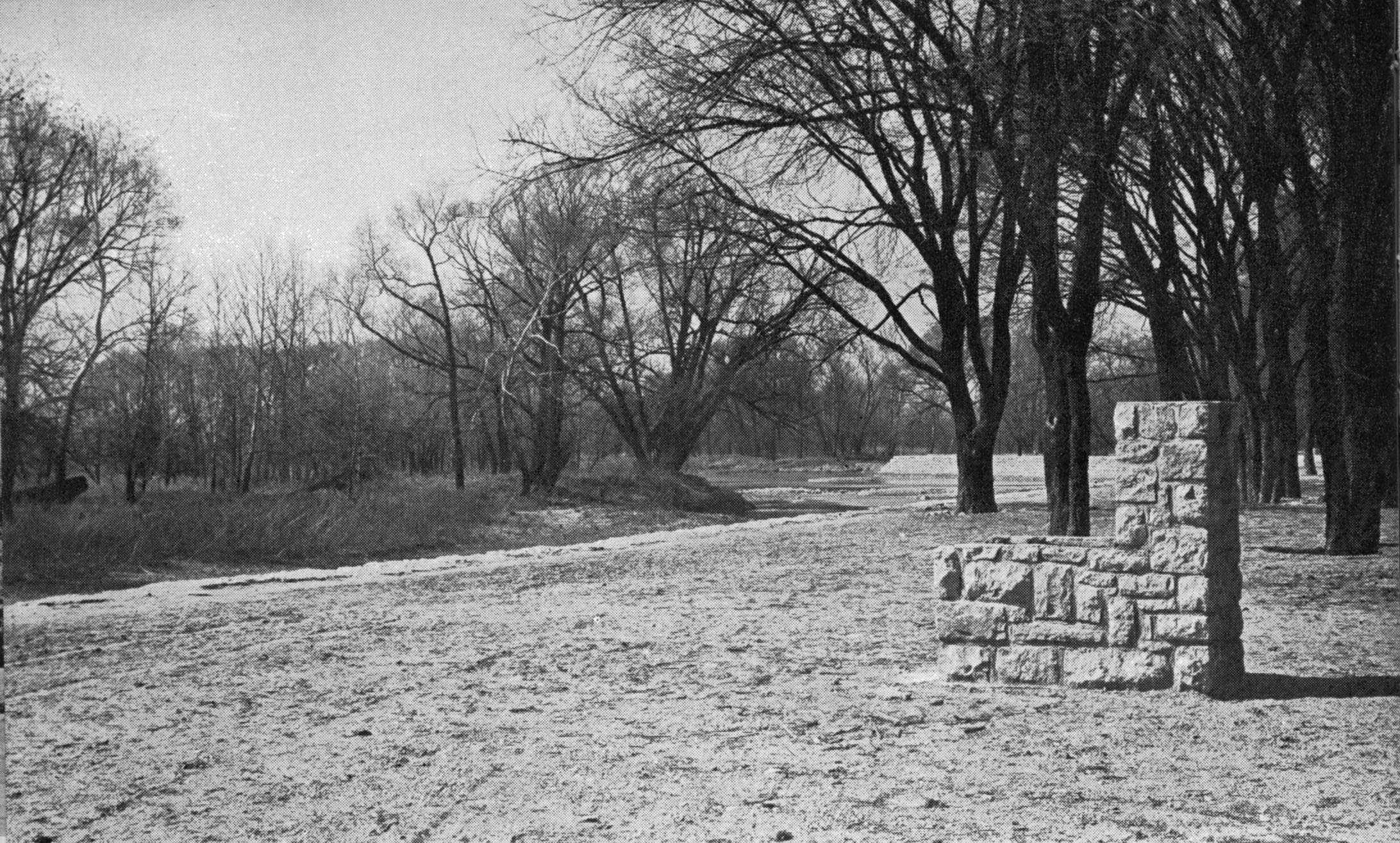 I assume this late 1930s picture was taken somewhere along the Olentangy River in the area of Clintonville. Note that both the trees and the stone structure are actually in the water. Does anyone out there recognize the location? [From a North High Memory Book]
The Zimmerman Family & the Olympic Swim Club

Libby Wetherholt recently gave this presentation about the Zimmerman family to the Clintonville Historical Society, and has kindly agreed to share it with us.
And More Markers!
Ron Irick recently alerted me to the Historic Marker Data Base. In it are photographs of several additional markers covering Clintonville’s notable people, places and events. The database includes the marker for Rand Hollenback, on Hollenback Drive at Whetstone Park, the Nat’l Register of Historic Places marker for East North Broadway Historic District, and the marker (currently in Powell) for the Grand Carousel which was formerly at Olentangy Olentangy Park.
Ron recently posted the Clinton Township/Clintonville Historic Marker.
Though not in this database, there is also a marker for the Old Beechwold Historical District. I believe there is also some sort of marker for the former home of the Republican Glee Club at 57 Weber Road.
The Grand Carousel–Request for Information
Carousel expert and author Eric Pahlke recently emailed me with a question. The question is about the Grand Carousel that currently operates at the Columbus Zoo & Aquarium.
Eric is trying to resolve some conflicting information about the history of the carousel. He writes,
The oft-repeated story is that the carousel came to Olentangy Park in 1914, and was moved to Scioto Ranch Park in 1937-38 after Olentangy closed. Scioto later became Zoo Park, which became Wyandot Lake Park, which is now a combination of Zoombezi Bay and Jungle Jack’s Landing. I have a source that says the city of Columbus bought the carousel in 1981. The carousel apparently operated at Wyandot Lake until 1999 and has been running at the Zoo since 2000.
The problem is that I have some photographic evidence that says the carousel started on Coney Island and didn’t come to Ohio until the mid-1920s. This alternative story doesn’t distinguish between the carousel then coming to Olentangy Park and then to Scioto, or directly to Scioto.
I’m hoping that someone has materials in their archives that would help solve this dilemma. The primary question is whether the carousel came to Olentangy Park in 1914 or sometime in the 1920s. After that is solved, the other issues probably follow.
Does anyone have any information that could shed light on the issue? Eric is the author of Treasures from the Golden Age: West Coast Carousels, and Treasures from the Golden Age: East Coast Carousels.
Have a Bash
 From Unforgettable Columbus, volume 2: “Although Herb Bash is not considered a pro, he did give lessons and was considered a pretty fair golfer. [Early on, he leased Indian Springs Golf Course.] In 1948 he opened a unique golfing complex on W. Dodridge St. between Olentangy River and the Olentangy River Rd. These 60 acres consisted of an 18-hole golf course and a large driving range. He sold the land in 1962 to Chemical Abstracts and moved his entire operation to just beyond Rte 161 on Dublin Road…The driving range on Dodridge was a place where many a Columbus duffer sharpened his game. Bash died in 1979 at the age of 86.”
According to Bill Case’s web site, “former South High coach Herb Bash … made his living in the golf industry. Herb and his wife owned the Berwick Golf Course, a public facility located on the city’s southeast side. Herb helped grow the game at Berwick by conducting numerous golf clinics for the city’s youths. Shortly after joining The Elks’ in 1928, Bash, in partnership with Bugs Raymond, opened another golf course- Indian Springs, opposite Henderson Road on the east side of High Street. Herb later added the “Bash Driving Range” in Dublin to his collection of entrepreneurial golf activities. Like many of his compatriots at Elks’-Wyandot, Herb Bash could golf his ball. Prior to joining The Elks’, he won Dublin Road’s club championship. Herb was also a mainstay of the 1932 Wyandot golf team which won the inter-club championship.” [Image courtesy of Bill Case.]
Olentangy Park Redux
 I never tire of seeing old images of Clintonville. Collector Galen Gonser shared these 1920 images with us. Admittedly they are taken with a simple box camera, but still, what’s not to like? (Photos courtesy of Galen Gonser.)
The first image below is Chute the Chutes at Olentangy Park.


We don’t know who these gentlemen are.


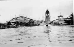
These images are taken looking north from Dodridge Bridge up the Olentangy River toward Olentangy Park–the second of the pair is a close-up.


For additional photos, search “Olentangy Park” on this web site.
Maple Syruping in Clintonville
 I can’t help loving this photo! Bob Fowle, left; Bob Scott, second from left; and Richard Knopf, third from right, around a kettle of sap in the old Clintonville neighborhood. (Photo courtesy of William Dunning)
Bill Case’s New Book about the Wyandot Golf Club
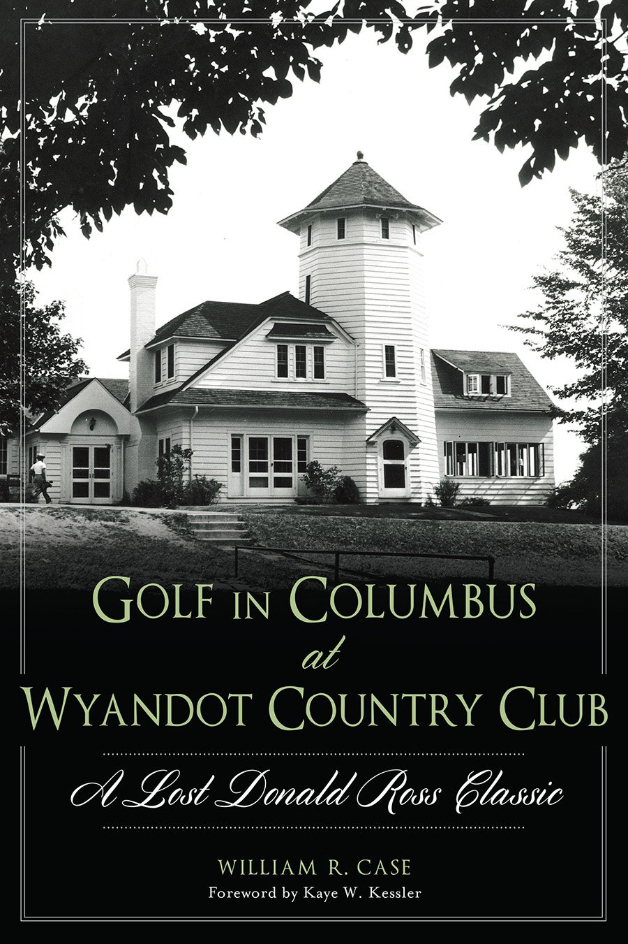 William R. Case has published a book about the Elks / Wyandot Golf Course. The book’s title is Golf in Columbus at Wyandot Country Club. As of this posting, The Book Loft in German Village (Columbus, OH) or Barnes and Noble at Easton Town Center have it in stock. If, like me, you are a prolific library user, you can also locate the book in a library near you here.
Bill has collected lots of great photos and researched this golf course (now the location of the Ohio State School for the Blind and the Ohio School for the Deaf) extensively. You will enjoy his book! [Images courtesy of Bill Case]
Can You Canoe?
 The Olentangy Park Canoe Club, ca. 1906. I’m told that at one time, Clintonville had at least 4 canoe clubs.
Beechwold Theatre
 This is an ad that just happens to show the signage of the old Beechwold Theatre at 4250 N. High (aka Camelot North and Drexel North, and currently an athletic club).
The theatre was built by the F & Y Building Service (aka F & Y Construction Company). Mark Fontana informs me that the “Y” in this name is Yassenoff, and the first manager of the Beechwold Theatre was Milton Yassenoff, adopted son of Leo Yassenoff.
If anyone out there is aware of the whereabouts of blueprints, construction photos and high-res b/w photos of the finished theater, please let us know! The ad was shared with me by Mark Fontana, former manager of the Drexel North (aka Camelot North and Beechwold Theater) Mark is a collector. In another place on this web site I link to his web site.
Donald Ross, and the Elks / Wyandot Golf Course
 Bill Case has done a wonderful job of researching and writing the history of Donald Ross’ design of the Elks/Wyandot County Club. Check out his web site here. It’s a work in progress so check Bill’s site frequently.
The first picture (to the left) is, of course, Donald Ross. In the left-hand image below, Harold J. Kaufman, John W. Kaufman, Arthur Shannon, Donald Ross, and J.V. Taylor peruse a topo map.
The right-hand image below is the 5th hole–308 yards–par 4. See Bill’s web site for the history and for more image gems.


(Images courtesy of Bill Case and Betty Huber)
Baseball at the Zoo
 The zoo in Beechwold may have been one of the earliest sites of the Columbus Clippers!
According to Joe Santry, Historian at The Columbus Clippers, “In 1895 the Columbus Statesmen opened the season playing at The Zoo Baseball Grounds. The grounds were owned by the Zoological Garden company. Could this be the old zoo grounds in Clintonville? …The team played at the Zoo Grounds for a couple of months before moving to Recreation Park in German Village…
“In 1895, according to the local papers, Columbus played at ‘the Zoo Grounds’ (May 21), ‘Zoo Baseball Park’ (May 4), ‘Zoo Park’ (May 5). There are stories about temporary grandstands, then a ‘new grandstand’ (May 12).
“By June 1, however, the OSJ reports that the club now ‘holds the lease on the Schiller street grounds’ and the club ‘will play the last game on the Zoo grounds this afternoon and the work of removing the grandstand, bleachers, and fences to Recreation Park’ will follow.
“The problem is how inconsistently the papers reported the games that season. The more I research this the more I think the Zoo Grounds park was in or near some type of amphitheatre on the zoo grounds. The park had other smaller attractions prior to 1905.”
Scott Caputo, librarian at the Columbus Metropolitan Library, found this article in the 8-8-1904 Ohio State Journal. It mentions a drill field and a ball game used by several masonic groups at the Zoo. This, shortly before it closed down.
Also linked here is a image/map of the old zoo, courtesy of Mary Rodgers of the Clintonville Historical Society.
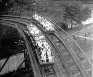
Old Olentangy Park picture
 What a terrific picture of Olentangy park, courtesy of Peg Steigerwald. She would like to know what the ride is
at the top left corner of the photo is–not the larger slide water ride, but more of a love canal type covered ride. Anyone know? (Photo courtesy of Peg Steigerwald)
Lulu Browne Remembers
 Elsewhere on this web site, I’ve praised Lulu Pearle Browne, who in 1992 gave a presentation to her church, Maple Grove United Methodist Church, and in so doing preserved some wonderful Clintonville history. Her son Ron and the church allowed me to copy some of the materials that she prepared for these presentations, as I wrote my book. Some of the material can also be found elsewhere on this web site.
Just for the archival record, I’m also including PDFs of the some of the material Lulu wrote.
She wrote her memories of some of the plays the Maple Grove community produced, up to and including the 1950s (29 pages); and she gave a presentation on changes in the neighborhood (24 pages).
(Documents courtesy of the Ron Ohsner family)
Full of Glee
 I love the story of the Republican Glee Club. Here it is: It was 1872, shortly after the nomination of Ulysses S. Grant for his second term of President. Some men were enjoying a convivial evening in one of the rear rooms of the Old Ambos Restaurant and Café on South High Street, and discovered that they all liked to sing and all were Republicans. Henry W. Frillman, one of the group, had just returned from Chicago and reported on the activities of a political glee club he heard sing there. The men decided to start a Republican singing and marching club, and called themselves the Grant and Wilson Glee Club. They rehearsed rigorously and became much in demand at rallies around the state. They were even invited to take part in the inaugural festivities in D.C. After the election, the group disbanded but in 1876 reconvened as the Hayes and Wheeler Glee Club. Members participated in four successive campaigns, and participated in state and local campaigns as well. In 1895 they incorporated as “The Republican Glee Club of Columbus Ohio.”
In the late-1920s, they moved their headquarters to 57 Weber Road and remained there until about 2000. The building is now a private residence. (Photo courtesy of Tom Atzberger)
Broadway House No. 1
 North Broadway was developed by the Loren and Dennison company in 1897; it was intended to be the place to live, and it was. James Loren originally planned to call it the Oakland Addition, but the post office requested he change the name to avoid confusion with another neighborhood. It had a small railroad depot and post office at North Broadway’s east end at the Big Four Railroad track. This house at 510 North Broadway Street was the first house built in the subdivision. It was built around 1890. It was sometimes called Acton Place, for reasons I was unable to discover. By 1894 it was owned by a man named E. Howard Gilkey. The William W. Daniel family purchased it in 1896, and the house remained in that family’s hands until 1961. It burned down in 1966. My Clintonville and Beechwold book has a photograph of the original house; this photograph shows the fire. The spot is now occupied by Columbus Speech and Hearing Center. (Photo from an unnamed newspaper clipping)
Are You Ready for the Football?
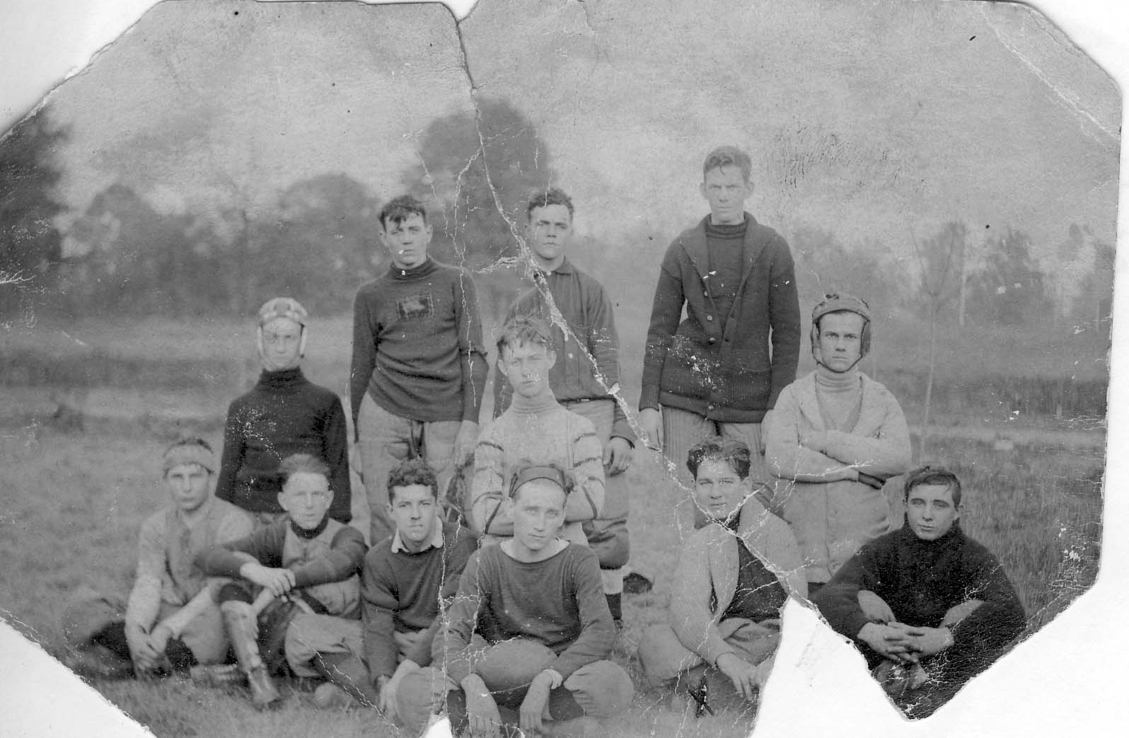
Here’s the 1908 Old North Columbus Boy’s Football Team. Top row: Lee Billing, Pick, Bud Campbell. Center Row: Daygo Matthews, Art Rodes, Harold Caine. Also in picture: Nate McCoy, Charles M. Jones, Gazaway Moccabee. (Photo courtesy of Frank Jones.)
Jeffrey Outbuilding
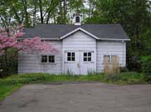 The old barn, an outbuilding of the Columbus Zoo, and eventually the Jeffrey summer home in Beechwalde, still stands and was remodeled, on the request of the homeowners, by students at the Interior Design Institute in 1983 for use as a guest house. (Photo courtesy of Terry Miller)
Beechwalde
The photos you are seeing here are lovely images of the Beechwold area (west side of High Street) before, or as, the land was being developed into the housing subdivision we know today as “Old Beechwold.” Some of these photos were later used in a promotional brochure–a lovely brochure called “Beechwold the Beautiful,” with a dark green heavy paper cover tied with dark green string with engravings by the Bucher Engraving Co., illustrations and text by Stacy G. Taylor, and printed by the Stoneman Press Company. This same brochure has recently been reprinted by the TWIG organization for use as a fundraiser.
Why the spelling change? Previous owners Joseph Jeffrey had named his country estate “Beechwalde,” and it was changed to “Beechwold” for marketing purposes (=easier to spell) when the land was subdivided and sold for housing units by Charles Johnson.
These photographs were given to me by the granddaughter of Frank Sweigart; Frank worked for Charles F. Johnson for eight years. I am mounting the Beechwold photos in several postings to facilitate some comparisons.
(Images courtesy of Karen Sweigart Longava)


Beechwalde Cont’d #1


Compare these two images–a photo (albeit reversed) from the collection of Karen Longava Sweigart (granddaughter of Frank Sweigart), and a watercolor print from the promotional brochure from the early days of Old Beechwold. Did the photo inspire the watercolor? (Images courtesy of Karen Sweigart Longava)
Beechwalde Cont’d #2
Compare these two images of this wooden structure located somewhere on Beechwold property as the property was being subdivided into a housing development. You can click on the thumbnails to see them in a larger format.
 The first photograph shows tire tracks driving right up to the opening between the two sections of the structure. In that photo there are window panes in the windows, and the structure is surrounded by brush and foliage.
 In the second photo, the windows and the foliage are gone. A different photo of the structure during this era is found in my book, Clintonville and Beechwold.
I have been unable to find anyone who remembers the structure first-hand. (The first photo is courtesy of Karen Sweigart Longava; the second photo courtesy of Amy Westervelt.)
Beechwalde Cont’d #3
Compare this watercolor from the promotional brochure for Beechwold, Beechwold the Beautiful, to the image found in my book, Clintonville and Beechwold, on page 26. (Image courtesy of Karen Sweigart Longava.)

“It’s Great Fun”
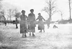 The river was a favorite skating spot in the early part of the century. Children also sledded on East North Broadway, and on “Mooney hill” at 259 Walhalla Road. In the summertime, there was a swimming hole colloquially called Bare-ass Beach in what is now Whetstone Park plus a legendary skinny-dipping spot in the river at the “Holt farm” near the C.D.& M. Interurban line’s Stop 18 around Lincoln and High. (Photo courtesy of Amy Westervelt)
1916 Football
 This is the championship Clinton Township High School football team of 1916, with Rand Hollenback (the one whose teammate has his hands on Rand’s shoulders).
Chesnut House

And another amazing old photo of North High Street from Stu Koblentz. This photo also looks north, and was taken just south of the intersection of High and North Broadway. The house on the west (left) behind the little shack (marked “ice”) is the Chesnut house (aka Chestnut house), described in this web site’s “Water for Cookies” entry and also found in my book. The school on the east (right) side of High Street is the old Clinton Township school building, a picture of which is also in my book. You can click on the image to see it in more detail.
Stu’s theory about the Chesnut house is as follows:
The image shows the Chesnut house, facing North High Street, about where it currently stands. The facade that faces Wall Street today is the facade facing High Street. This is verifiable in the chimney placements.
So I went through Joe Testa’s web site and I think I know what happened to the house.
As far as I can tell the house stood approximately at 3327-29 North High Street. In the 1910s, when the house (which appears to have been built in the 1860s or 70s) is pictured, the house had been moved on a pivot to its current location, with its northeast corner remaining close to its original placement. This would account for the front lot build out, the twist in the alley and the sudden reemergence of Wall Street as well as the placement of the house in the picture, and the current location of the house.
What is interesting to me is why did they go to all that trouble, when its fairly common in urban settings to build a street facade onto a house and call it a commercial building. I think that part of the reason is that the house sat further back from High Street, making it too far away to convert to a commercial space commonly found in that era.
Update 2025-08-25 by Shirley–Another possible reason for reorienting this house might be found here.
The play’s the thing


In 1925, members of Maple Grove Church presented a play at the church. The play was Friendly Helpers Class. It was a success and was taken on the road to the Linworth and King Avenue Methodist Churches. The left photo shows cast members Katherine Cooke (Barbee) and Lulu Browne (Ohsner), Dorothy Cooke (Hambleton) and a neighbor playacting for the camera in 1925. The photo on the right is the program for the June production. (Photo courtesy of the Ron Ohsner Family)
The Park
Around 1880, Robert Turner founded the Olentangy Villa Tavern. It was a small picnic grounds and offered boating and swimming, perhaps a couple rides. By 1895 the park came to be owned by the Columbus Railway, Power and Light Company; enabling the electric company to earn money from both its electric streetcars and from electricity at the park, and ensuring streetcar traffic (with its use of electricity) not only during weekdays when commuters traveled to their jobs in the city, but also on weekends when residents traveled by streetcar to the park. In 1899, brothers Joe and Will Dusenbury purchased about 100 acres of the park and built it up into a state-of-the-art amusement park with nationally renowned entertainment in a lovely, picturesque setting. They offered rides, a pool, bowling alley, canoeing, an amphitheatre, even a Japanese Village purchased from the St. Louis Exposition. Many long-time residents recall happy and exciting days spent at the park.

Eventually the park began to decline, and was eventually sold, and then sold a couple more times. In 1937 L.L. Leveque purchased the park and in 1939, built the Olentangy Village Apartment Community in the park’s place. (Photo courtesy of the Clintonville Historical Society)
South Glen Bridge
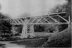 The streetcar came right to the entrance of the park, and from there attendees walked over a pedestrian bridge to get into the main park. This is a picture of the “South Glen Bridge.” (Photo courtesy of Chris Bourne)
Loop-the-loop
 Loop-the-loop and Shoot-the-Chutes were among the favorite rides at the park. Loop the Loop took riders on a 360-degree vertical loop. The unruffled gentleman appears unconcerned about gravity in this well-known image of the ride. The ride was said to be accident prone and was eventually torn down. (Photo courtesy of Galen Gonser)
Shoot the Chutes
 This photo shows, left to right, the Whirl Wind, Shoot-the-Chutes, and the Racer. Shoot-the-Chutes involved a long slow boat ride to the top, followed by a creaky turn, and then a steep descent, hitting water and wetting the riders to their unabashed delight. It was one of the favorite rides in the park. (Photo courtesy of Chris Bourne)
Fun at the Park
 Anyce Milam, a Columbus resident, shared these two postcards of the Olentangy Park with me for use on this web site. The first is a color picture of the ride, Loop-the-Loop, which had quite a few accidents and therefore did not last long in the park.
 The second postcard image was taken on the river near the Park’s canoe livery. The postcard was dated 1917. (Courtesy of Anyce Milam)
Clinton-Como Park…
 was originally called the American Legion Park Playground, presumably because Post 82 owned it or gave it as a gift to the community. Today there is a conical mound at the park. The mound was “built” sometime in the 1960s (tentative date) from the dirt displaced by sewer line construction.
Columbus Canoe Club
The house that currently stands on the north side of Orchard Lane at the river was once the Columbus Canoe Club. It has had only 4 owners in its lifetime, and the present owner had to do considerable renovation on the building. The club originally had tennis courts; the space is now a swimming pool. Sadly I know of just one photo of the club, which is located at the Ohio Historical Society. The current home owner told me that Bill Arter, an artist who drew and researched Columbus buildings in a Dispatch column called “Columbus Vignettes,” was in the process of writing a column about the club when he passed away.
Tennis
 The Clinton League created a community tennis club and tennis courts on Dunedin near Calumet Street, using two vacant lots owned by J. E. Pierson.
Lehman Machine
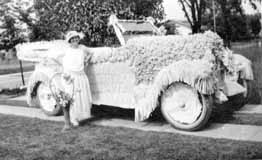 During Clintonville’s early years, it had many parades and this is one of the floats. The back of the photograph is labeled the “Lehman Machine” (machine was another name for automobile). According to the 1923 city directory, there was a David and Hattie Lehman living at 47 West Brighton Road. David was a sales manager for the Iron Clay Brick Company, and Hattie was a hemstitcher. (Photo courtesy of Amy Westervelt)
Brighton Road wins in parade for second time!
“Several thousand residents take part in North Side Field Day Celebration! Enthusiasm high!
“On a hot and sunny Saturday, June 2, 1923, the North Civic Association sponsored its annual celebration. Brighton Road, owner of the previous year’s wreath, captured first honors in the parade for the second time, while Longview Avenue challenged for second place. Brighton Road received $50 and Longview, $25.00. The impersonation of a number of historical and present prominent men was the feature of Brighton’s representation. The first prize for the best decorated automobile also went to this street, which produced a car encased in pink roses…”—from the Columbus Dispatch Sunday June 3, 1924
Playing on the railroad
 Brevoort brothers Frank Jr., Gordon, and Dale play on a railroad box in or near Worthington, in 1931. (Photo courtesy of Gordon Brevoort)
The Zimmerman Family and Olympic Swim Club
Libby Wetherholt recently gave this presentation about the Zimmerman family to the Clintonville Historical Society, and has kindly agreed to share it with us.
—
The Zimmerman Family and Olympic Swim Club
by Libby Weatherholt, March 8, 2016
The History of the Olympic Swim Club starts with Orr Samuel Zimmerman. (Photo courtesy of the Upper Arlington Historical Society)
Orr S. Zimmerman was born in Oakwood, Ohio in 1890 but moved to Columbus with his family when he was a child. He was educated in engineering at Ohio University and transferred his interest in mechanics to a career in the family automobile business.
In 1913, Zimmerman married Ethyle Cather, a native of Athens, Ohio. They moved to this house at 645 Dennison. (Photo courtesy of the Franklin County Auditor’s web site, property ID 010-044708 4/27/2014)

By 1916 the Zimmermans had begun building the house below at 1790 Cambridge Boulevard. (Photo courtesy of the Franklin County Auditor’s web site, property ID 070-000571 4/18/2014)

An historical picture can also be found on the Upper Arlington Historical Society web site.
The birth of their sons Robert Orr Zimmerman and Richard S. Zimmerman followed in 1918 and 1922, respectively.
By 1930, Audrey Ethyle Zimmerman had passed away and Orr had married Alice M. Zimmerman. The family had moved to 4497 Olentangy River Road—a house that remained an important part of the family history. (Photo courtesy of the Franklin County Auditor’s web site, property ID 010-006577 3/17/2014)

Zimmerman built the house in 1929 on what was then a 52-acre estate; at the time, Henderson was a country gravel road and Olentangy a narrow two-lane street. The architect was Thomas Tulley. Interior walls were decorated by a New York artist, with beautiful wooded scenes in both the trophy room and the living room. Two Canadian bear cubs, captured on a hunting trip, were raised in a small house on the property. In 1977 the house was a Decorators’ Show House. The house was destroyed in January, 2016.
Mr. Zimmerman had a special interest in outdoor sports, particularly hunting and fishing. Zimmerman’s hunting expedition in the Canadian Rockies with Upper Arlington founder and resident Ben Thompson was detailed in a November 1920 issue of the Norwester, complete with descriptions of the large game seen and hunted by the pair in British Columbia. Zimmerman submitted his own account of the trip to the Norwester, documenting the geography and vegetation of the region. (The Norwester magazine, published November 1917 through March 1922, chronicled early suburban life in the Upper Arlington, Grandview Heights, and Marble Cliff areas.)
Zimmerman also enjoyed pitching horseshoes and playing baseball. In 1920, he served as captain of the Upper Arlington “Lobsters” who battled the rival “Crabs” in the village baseball tournament. Mr. Zimmerman personally donated the “Zimmerman Cup,” the trophy awarded to the winning baseball team. He was also a member of the Upper Arlington Fishing Club and the president of the Upper Arlington Gymnasium Club, which oversaw the organization of indoor sports such as hand ball and volley ball. He was active in the Kiwanis and Athletic Clubs, and served as director of the Columbus Auto Trade Association.
The 1915 City Directory documents that Orr S. Zimmerman and Walter B. Charles owned Ohio Auto Sales Co. at 772-774-776 North High Street.

On June 30, 1941, Thomas Tully and Orr Zimmerman filed for a patent titled Means for producing formed strips of plastic materials, US 2323862 A. The patent was granted on July 6, 1943.
Richard Zimmerman married Dorothy Rupp, his high school sweetheart. They were parents of three children: Lynda, Ric, and Dan
Richard S. Zimmerman and his father, Orr Zimmerman, purchased the Olympic Beach from Frank Hauf in 1938, the same year it was built. The pool remained under ownership by members of the family until it closed in 2014.
Newt Jones, one of Richard’s grandchildren, purchased the Olympic Swim Club from his grandfather for $325,000 in 2002. Richard died shortly after on October 23, 2002 at the age of 81.
In 2014, Columbus Monthly Magazine staff picked Olympic Swim Pool as Columbus’ “best pool for athletes”:
For athletes: Olympic Swim Club
Built in 1938 and originally known as Olympic Beach, the Olympic Swim Club is a Columbus classic. Ohio State divers and swimmers practiced here in the ’70s and ’80s. Even Buckeyes football players would spend their off days at the club. After 76 summers, though, this is the Olympic’s last. “It was a business decision, but a very emotional and very sad one,” says third-generation owner Newt Jones, who has owned the Olympic for the past 13 years. Don’t miss your last chance to dive off the club’s rare 16-foot diving platform and experience a piece of Columbus history firsthand. “We just want people to come out for the last summer and enjoy it,” Jones says.
The following item comes from Shirley Hyatt’s Clintonville History web site:
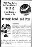
Will You Swim in Pure Water?
I love this ad for Olympic Beach in 1939. “Of interest to the ‘bathers’ of Northern Columbus is the care and precaution the management of the Olympic Pool is taking so that our families may swim in perfectly safe water, free from impurities and its dangers…“ Shortly after the pool was built, the Olympic Amusement Corporation, headed by Orr Zimmerman, assumed ownership of the pool. For many years the O.S.U. swimming and diving teams practiced there and many contestants for the summer Olympics came from all over the United States to train at the pool. Several national championships have been held there. Early on, only male lifeguards worked at the pool.
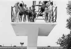
Here, someone does a kamikaze dive off the tallest tower.
(Photos courtesy of the Zimmerman family)
 One of the early reasons for Olympic Pool’s notoriety and draw was its double platform diving board and its dive pool. The double platform survived into the 1990s, at which time the higher platform was removed.
The following images are from the Olympic Swim Club’s Facebook page.


Minstrel shows
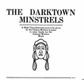 In the early part of the twentieth century, many Clintonville organizations and churches held minstrel shows, as fundraisers and for entertainment. I chose not to sanitize minstrel shows from my book, because they were an authentic part of Clintonville’s history, albeit the part we are all glad we’ve done away with. I regret any offense or hurt caused by these pictures.
Elks Country Club
 I loved the story of Lawrence Huber (1893-1958) and his wife Eunice Louise Dougherty (1900-1986). Lawrence had applied for a job at the Elks Country Club. They told him they wanted the incumbent to be married, so he asked his girlfriend Eunice to marry him. She accepted and they married in 1922–and remained married the rest of thier lives.
Huber, under the direction of Donald Ross, helped to construct the Elks Country Club golf course, which was located north of Morse Road and east of High Street to Indianola Road. Huber eventually took  over the position of groundskeeper when the course opened the following year. Lawrence and Eunice, and their three children, lived in a residence on the Elks Country Club property while Lawrence was employed there. Huber was extremely innovative, and invented equipment as needed to cultivate and care for the greens. (Photo courtesy of Betty Huber)
Another kind of bridge
Does anyone out there have a picture of the Clintonville Bridge Club, which met in the basement of the Olentangy Village Tavern for perhaps 50 years until the 1970s/1980s?
Will you swim in pure water?
 I love this ad for Olympic Beach in 1939. “Of interest to the ‘bathers’ of Northern Columbus is the care and precaution the management of the Olympic Pool is taking so that our families may swim in perfectly safe water, free from impurities and its dangers…“ Shortly after the pool was built, the Olympic Amusement Corporation, headed by Orr Zimmerman, assumed ownership of the pool. For many years the O.S.U. swimming and diving teams practiced there and many contestants for the summer Olympics came from all over the United States to train at the pool. Several national championships have been held there. Early on, only male lifeguards worked at the pool.
 Here, someone does a kamikaze dive off the tallest tower. (Photos courtesy of the Zimmerman family)
Indian Springs Golf Course Trophy
 As the author of a book on the History of Clintonville, I often get fun calls from people who own a tiny bit of Clintonville history and want a bit more. This morning was one of those days. Ian Crowe called me from Utah. He’d purchased a trophy at a local estate sale, and was wondering where the trophy was from and who won it.
The trophy was for an Indian Springs Golf Club, in 1931. Could it be Clintonville’s own Indian Springs Golf Club?
Apparently Ian had called quite a few golf clubs by the same name, until he found my web site.
I referred the question to Scott Caputo at the Columbus Metropolitan Library. His research can be found here. He learned that the golf course did exist in 1931–Indian Springs Golf Club was listed in the telephone directory as early as 1929, and had been issued a building permit for a new clubhouse in 1931. He learned that there was a Norman I. Blanchard living on 385 Wyandotte, just 3-1/2 miles from the course. According to census records, Norman would have been about 23 or 24 at the time of the tournament.


So, the trophy is extremely likely to have come from the Clintonville golf course.
When I exclaimed that the trophy was really a martini shaker, I was informed that this was a very common form of golf trophy back then.
Great job, Scott!
Indian Springs Golf Course
 In a previous post, I mentioned getting a call about a golf trophy for Indian Springs Golf Club.
That same day, I happened upon this history of Indian Springs Golf Course, from The Booster, Friday, December 1, 1939, page 9-B.
In a nutshell:
–The land was originally part of the Dyer estate;
–Golf Course was laid out with 152 acres in 1926;
–Ground was leased by Herb Bash (who, I should add, later opened a driving range called Bash Golf on Dodridge–which he later sold to Chem Abstracts–and then opened a driving range in Dublin on Riverside Road);
–In 1938 the golf club became Overbrook Country Club;
–The first clubhouse was on North High at Cooke Road
–By 1939 the club was open year-round, catering to parties and dances.
Indian Springs Golf Club
 The 46-acre Indian Springs Golf Course extended east of High Street to Indianola, north of East Cooke Rd and south of Schreyer. It opened as a 18-hole course in 1931 and closed circa 1947 as a 9-hole course. The Indian Springs Village subdivision was built in this location around 1947. (Photo courtesy of Columbus Metropolitan Libraries)
Robert Ohaver (1937-2009)
Robert Ohaver (b. 1920) lived most of his life in Clintonville and on West North Broadway. He had many stories of old Clintonville to share with us. On September 12, 2003, several community members (Ann and Alan Woods, Barbara Hotchkiss, Nancy Kuhel) interviewed him and preserved the conversation on tape. Now you, too, can listen to Mr. Ohaver’s oral history.
Sadly, Bob Ohaver passed away on June 11, 2009. You can find his obituary here. There is another small entry about his aunt on this web site here.
Bob mother was Laura Ohaver and his father was Walter Harvey Ohaver. Bob also had an older brother named Jack Ohaver who lived in Clintonville at 116 E. Dunedin with his wife Clara Ohaver. Clara passed away May 24, 1993, and Jack passed away on June 14, 2000. Jack and Clara had two daughters. Sue Bowman was born May 8, 1940; she passed away January 4, 2000. Sandra Urban born July 30, 1945. [This family information came to me from Jack’s granddaughter and Sandy’s daughter, Lisa Adkins. Thanks, Lisa!]
Each file is about 30 minutes long.
Contents
Track 1.
Brief Ohaver biography; origins of his family moving to West North Broadway; his World War II years; Clinton Theatre; businesses and homes at the interesection of North Broadway and North High Streets; drugstores and candy stores in Clintonville; the house behind 3391 North High Street; Dispatch carrier’s substation; Olentangy Park; the streetcar storage barn at Arcadia.
Track 2.
Olentangy Park cont’d; street fair at North Broadway and High to celebrate Clinton Theatre, the opening of Clinton School pedestrain subway, and the paving of North High Street after a new sewer line had been installed; the Olentangy River; 3 canoe clubs; development of West North Broadway (“the Broadway Extension”) and the Scott farm; development of the area along the adjoining river bank; the Herron [spelling uncertain]/Zinn home at 285 West Kenworth; Bill Moose AKA “Indian Bill”; Chief Leatherlips.
Note: the “Dr. John Scott” is William H. Scott, president of OSU 1883-1895. See my book, page 17, for a photo of his house.
Track 3.
Chief Leatherlips cont’d; house at 273 Erie Road and excavation of nearby gravel pit; the Fuller farm/Whetstone Park; rambling through the woods; Indian Springs golf course; Bill Moose AKA “Indian Bill”; Olentangy Park; North Columbus including the Ramlow Building; Picadilly Theatre; streetcars and interurbans.
Track 4.
Southwick funeral home; Joy Hunt home; Graceland Shopper’s Mart and Patrick Murnan; Clinton Theatre; the Great Depression; Ohaver family; Brighton Road development; Ohaver’s WWII and postwar years.
Track 5.
Ohaver’s return to Columbus from California in 1962; bombing of the Clinton Theatre in the 1930s.
Turkey Bowl Tickets
 My book contains a photograph of the annual Turkey Bowl, a football game held in a local park on Thanksgiving day. Attached is a picture of some actual tickets to the event, for 1944! Betty Daniels gave these to the Clintonville Historical Society. [Photo courtesy of the Clintonville Historical Society]
Mayor George Sidney Marshall
 One of Clintonville’s notables was George Sidney Marshall (869-1956). He was raised on a farm in Perry County and attended Ohio State University. He graduated from OSU in 1894 and then from its law school in 1897. He was active in local politics, and became mayor in 1910 on the Republican ticket. After his term of mayor, he returned to the practice of Law and retired in 1946. He and his wife had a longstanding interest in music, and formed the Clintonville Music Study Club. In his retirement (and after the death of his wife), Marshall wrote a history of music in Columbus, a thorough account of all the local nonprofit musical organizations across the city. His book, called The History of Music in Columbus, Ohio, covers the period from February 14, 1812 to July 1, 1953 and was published by the Franklin County Genealogical Society.
George Sidney Marshall’s son, George B. Marshall, was also an attorney and served as a Franklin County Common Pleas Court Judge for 26 years. He retired in 1980 and died in 1981.
Fuller Farm & Whetstone Park
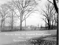 E.A. Fuller was a prominent Clinton Township horse trader at the turn of the century. I found the Clinton Township records for the late 1800s and early 1900s, and his name was frequently mentioned as buying or selling horses. I assume that the so-called “Fuller Farm”—where Calvary Bible Church, Whetstone Park, Clintonville Women’s Club, and The Church of Christ, Scientist are today—once belonged to this man. (Photo courtesy of Calvary Bible Church)
The vacant farm has been put to many uses. During World War II, the land used for victory gardens. (There were also victory gardens near Riverside Hospital.) Children put the area to their own purposes, scrambling through the undergrowth and playing by the river.  Many long-time residents recall a family that lived in the farm house—some have called it a log cabin, others say it was a chicken coop–of the old Fuller Farm. Some say the family was partly Native American; others say partly Romani; in any case, the family’s race added to their mystique and exoticism in the minds of the Clintonville children of the time. The family’s surname was Windsor; Mr. Windsor was a professor at OSU, and many of the people fondly recall daughter Zolithia [or Zelitha] (back row, 4th from left) and her brother Romanus (3rd rw, 2nd from right).
During or shortly after World War II, Rand Hollenback (founder of The Booster) lobbied for remaining land to be converted into a park, and the City of Columbus purchased the 161 acre farm. It became Whetstone Park. From early on the park has included a casting pond, softball diamond, tennis, picnic and playground, and archery field.
Drexel Theater
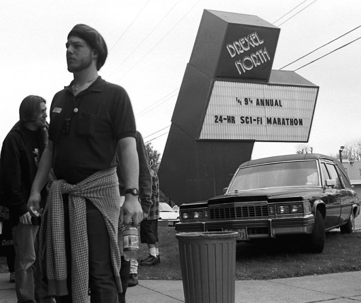 Mark Fontana is a former manager of the Beechwold Drexel North Theater, and he has started a Facebook page devoted to preserving the history of this theater. Also known as Beechwold Theater or Camelot North, it was located at 4250 North High Street and the building currently hosts the Columbus Sports Connection. When the building was a theater, it also served as temporary worship space for several churches in the area while the churches were being enlarged or rebuilt. Check out Mark’s web site!
Adena Earthwork
 It breaks my heart to learn about the Overbrook Ravine Earthwork (an Indian Mound) located at the southeast corner of Yaronia and Wynding Drive. The earthwork consisted of two earthen mounds surrounded by a 400-foot diameter circular earthen embankment, built over 2500 years ago. Though the city and developers were glad to build a park around the mounds, residents worried about traffic such a park would draw. In 1953 the mound was destroyed to make way for housing construction. (Map courtesy of Franklin County Engineers)
Park of Roses
 Members of the Columbus Rose Club & The Central Ohio Rose Society had long dreamed about a municipal rose garden for Columbus. Late in 1951 a committee was formed, consisting of members from both rose clubs, meeting several times with Mayor James A. Rhodes. The result being on April 19, 1952 Columbus City Council passed an ordinance and issued bonds for the Park of Roses. At the same time the Mayor created an advisory council known as the Columbus Rose Commission, administered by the Columbus Recreation & Parks Department, whose duties were to plan and execute a rose garden to be located in Whetstone Park. George B. Tobey, landscape architect, joined the efforts for park design and development. (Photo courtesy of the Clintonville Historical Society)
 Construction began June 1952. Minimal grading was necessary as the gentle slope of the meadow was ideal for drainage and air circulation. The entire area of 13 acres had sandy loam topsoil to a depth of 11-15 inches, which was indeed fortunate. All beds were excavated to a depth of 24 inches. The existing soil was removed and mixed with imported peat moss and commercial fertilizer. The materials were mixed four times before returning to the beds. The beds were allowed to settle before any planting was begun. (Photo courtesy of Terry Miller)
Bowling
 There were at least 3 bowling alleys in Clintonville: Olentangy Bowling Center (shown here), where Giant Eagle is today; at Graceland (northwest end), and also on the east side of High Street between Oakland Park and Dunedin. Hanging out at bowling alleys was a big deal for many teenagers—whether you bowled or not was immaterial. (Photo courtesy of Galen Gonser)
Fourth
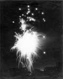 Clintonville’s Fourth of July celebration goes back at least as far as the 1930s, when The Booster and local business association sponsored an annual summer or fall community picnic at Olentangy Amusement Park. (The annual get-together may well be older yet.) Much like today, the early events had pet parades, bike parades, and fireworks. After the amusement park closed, the annual event was held at the Columbus Zoo. And then, when Whetstone Park was dedicated in the early 1950s, the community picnic was moved there and “annualized” to be held on the Fourth of July. The annual community breakfast, originally held for the volunteer workers of the Fourth of July picnic, quickly became another holiday tradition.
Through Rose Colored Glasses
 In 1954 Nancy Blanchard, a 16-year-old student at Mifflin High School, became the first winner of Maiden of the Roses competition. The pageant, a yearly event held each June at the Park of Roses and sponsored by North Columbus Civitan, was held from 1954 until 1974. Thanks to Nancy and her cousin Joyce Schatz, we have Nancy’s clippings file from that era, and that newspaper articles are linked to the thumbnail images below as PDFs. [Clippings courtesy of Joyce Schatz.]


Kiwanis Cont’d
Here are more pictures showing a few of Kiwanis’ contributions to Clintonville–
World War II memorial to fallen soldiers at Union Cemetery;softball team sponsorship; scholarship program; Easter egg hunt at Whetstone.


A Rose by Any Other Name…
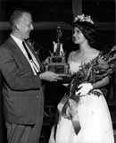 I’m enthralled by pictures of the Maiden of the Roses pageant, held at the Park of Roses each Father’s Day from about 1954 until 1974. The pageants were sponsored by North Columbus Civitan. They evoke an era which is now gone. The celebration included floats, a dance, and the beauty competition, with the award given to the Franklin County girl who “made the greatest contribution to the community and who has worked most in her school.” The 1964 Maiden was Lynn Wilson, from Upper Arlington High School. (Photo courtesy of Glenn Williams)
Maiden of the Roses Theme Song

From 1954 or 1955 until 1974, North Columbus Civitan (along with Columbus Parks & Recreation) sponsored a Maiden of Roses Festival at the Rose Garden. While rummaging through Civitan’s archive for the festival, I came across a written composition of music, clearly intended to be played at the festival and perhaps at the award event. I don’t know who composed it (does the sheet say, “Al Waslon”?). My musician friend and technical advisor Mark Bendig played and recorded the tune for me and now you, too, can listen to it. Click the play button below to stop/play the music. (Access to Civitan’s archive courtesy of Glenn Williams, music courtesy of Mark Bendig.)
Marathon
 The Columbus Marathon began in 1980 and participants ran through Clintonville during its first three years. Runners ran north on Kenny to Henderson, over to the bicycle path then south to Piedmont, east on Piedmont to Calumet, then south toward campus. This picture shows Robert Koch at mile 21 near Arcadia Avenue and Calumet Street. (Photo courtesy of Robert Koch Family)
Halloween
 I wonder how long school children have been parading in their costumes on Halloween day. Certainly they were doing so early on at Glenmont Elementary School. In the early days, neighbors probably turned out to watch the parade; nowadays they are more likely to watch from inside their houses. (Photo courtesy of Indian Springs Elementary School)
Whetstone Prairie
 The Whetstone Prairie was a joint project between the Columbus Recreation and Parks and Columbus Wild Ones, a non-profit community organization that promotes biodiversity and environmentally sound landscaping practices by using native plants to landscape city and suburban yards. They turned about 5 acres of lowland along the river just to the south of Adena Brook into a prairie using flora native to Franklin County. The Columbus Chapter began planning for the Whetstone Prairie in January, 2003. Seeding and planting was done in 2004. In 2005 the prairie bloomed with the spectacular results shown in this photo. In Summer, 2007, Wild Ones turned over the prairie to the management of the Columbus Recreation and Parks Department in a ceremony at the site of the prairie in Whetstone Park. My favorite time in the prairie is in the early morning during summer, when the sun is shining horizontally through the plants. (Photo by Craig Preston, and displayed courtesy of Marilyn Logue. )
Community Band
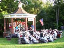 The Clintonville Community Band was founded in 1984 by Les Susi for North and Whetstone High School graduates as the North Columbus Community Band. In 1997 the name was changed to reflect participants’ true geographic ties. The Clintonville Community Choir was established 2005. The choir often performs music by Clintonville native John Ness Beck, a prolific composer of choral music. This photograph shows their August 2007 concert. (From the Clintonville Community Band’s web site)
Ravines
In my book, Clintonville and Beechwold, I stated that there are 4 ravines in Clintonville. Today there are 4, but originally there were, oh, perhaps 6. The area around Richards and Granden—which used to be called Richards Woods, before it was developed—has been filled in; and there is a low lying ravine between Clinton Heights Avenue and East North Broadway, which was also filled in quite a long time ago.