October 10th, 2008
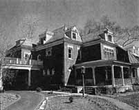
How I would love to acquire a picture of the old Schreyer House. This was described as being one of the first high-class homes in its neighborhood. The property was 50 acres, from High Street to the Olentangy River, bounded by Henderson to the south and the “Stewart and Weisheimer farms to the north.” The grand house was built by Barney Phinney (one of the owners of the Worthington Pike) about 1893, and was subsequently sold to G. Schreyer, a Columbus stove and furnace manufacturer.
Two excellent orchards grew on the place. A windbrake of splendid walnut trees protected one orchard and a row of fine maples formed the windbrake for the other. There was also a very good spring just west of what is now Rosemary Parkway. Surrounded by rose gardens and shrubbery, the house was an imposing structure with pointed gables and the interior finished throughout with solid walnut.
Mr. Schreyer died in 1901, and his wife (Ernestine Zeller, after whom Zeller Road was named) moved elsewhere. The old Schreyer house was eventually subdivided into apartments. The house burned down in 1913; the Columbus Fire Department had been called but could not respond, because there were no water lines in that vicinity at the time. The land was purchased by Charles Johnson in 1923 and subdivided into the Rosemary Development.
And as a side note: “Rosemary” was the name of Charles Johnson’s mother.
Tags: Charles Johnson, Henderson, Maple Grove Area
Posted in 1800s, Houses | 3 Comments »
October 10th, 2008
 This is a train wreck that occurred in 1880 north of Hudson, at the Big Four Railroad tracks. (Photo courtesy of Judy Cohen)
Tags: North Columbus
Posted in 1800s, Transportation | 3 Comments »
October 10th, 2008
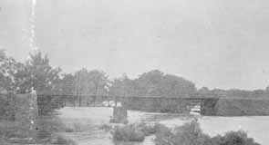 As my book shows, there was once a covered bridge over the Olentangy River at Dodridge Road. The Dodridge covered bridge was replaced by a truss bridge built by the Columbus Bridge Company. This picture shows the replacement bridge in 1890. Fishing from the bridge was a favorite activity for many 20th century Clintonville residents. It was a lovely river, and crappy and small mouth bass abounded. (Photo courtesy of Columbus Metropolitan Libraries)
Tags: North Columbus, Olentangy River
Posted in 1800s, Transportation | No Comments »
October 10th, 2008
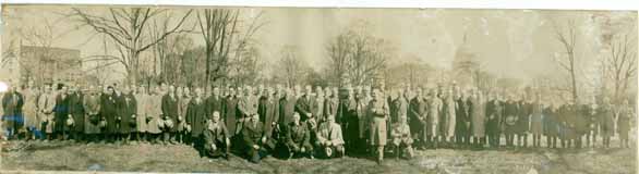 I love the story of the Republican Glee Club. Here it is: It was 1872, shortly after the nomination of Ulysses S. Grant for his second term of President. Some men were enjoying a convivial evening in one of the rear rooms of the Old Ambos Restaurant and Café on South High Street, and discovered that they all liked to sing and all were Republicans. Henry W. Frillman, one of the group, had just returned from Chicago and reported on the activities of a political glee club he heard sing there. The men decided to start a Republican singing and marching club, and called themselves the Grant and Wilson Glee Club. They rehearsed rigorously and became much in demand at rallies around the state. They were even invited to take part in the inaugural festivities in D.C. After the election, the group disbanded but in 1876 reconvened as the Hayes and Wheeler Glee Club. Members participated in four successive campaigns, and participated in state and local campaigns as well. In 1895 they incorporated as “The Republican Glee Club of Columbus Ohio.”
In the late-1920s, they moved their headquarters to 57 Weber Road and remained there until about 2000. The building is now a private residence. (Photo courtesy of Tom Atzberger)
Posted in 1800s, Parks & Recreation | No Comments »
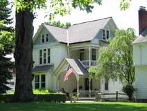
October 10th, 2008
 North Broadway was developed by the Loren and Dennison company in 1897; it was intended to be the place to live, and it was. James Loren originally planned to call it the Oakland Addition, but the post office requested he change the name to avoid confusion with another neighborhood. It had a small railroad depot and post office at North Broadway’s east end at the Big Four Railroad track. This house at 510 North Broadway Street was the first house built in the subdivision. It was built around 1890. It was sometimes called Acton Place, for reasons I was unable to discover. By 1894 it was owned by a man named E. Howard Gilkey. The William W. Daniel family purchased it in 1896, and the house remained in that family’s hands until 1961. It burned down in 1966. My Clintonville and Beechwold book has a photograph of the original house; this photograph shows the fire. The spot is now occupied by Columbus Speech and Hearing Center. (Photo from an unnamed newspaper clipping)
Tags: Evanston, James Loren, N. Broadway
Posted in 1800s, Churches, Houses, Parks & Recreation | 1 Comment »
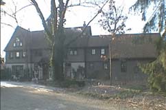
October 10th, 2008
 I also found a handwritten history that said that this was the first house built on North Broadway and was lived in, or owned by, someone named Loren. I do not recognize the house—do you? (This very poor image was taken from a photocopy of a microfilm.)
According to the 1896-97 city directory, there was also a Jeremiah C. Loren (motorman) living 1 building north of North Broadway on the east side of North High Street.
Mary Rodgers (resident of East North Broadway who has been researching the houses along East North Broadway) believes this is a picture of 625 East North Broadway, a house which was in the Broadway Villa subdivision and which I have written about here. It was lived in by the MacIntosh family.
Tags: Evanston, James Loren, N. Broadway
Posted in 1800s, Houses | 1 Comment »
October 10th, 2008
 East North Broadway was developed by the Loren and Dennison company in 1897; it was designed to be a posh neighborhood, each house on a 1-acre plot of land. It had a small railroad depot and post office at North Broadway’s east end at the Big Four Railroad track. This house at 242 North Broadway Avenue was the second house built in the subdivision. (From Business First magazine)
 242 East North Broadway was renovated beautifully by owner Gary Means. The care with which he selected materials and kept true to the house’s original design takes my breath away. The house has not always been so lovely. For several years–prior to the present owner–this (to the right) is what it looked like.
Tags: Evanston, James Loren, N. Broadway
Posted in 1800s, 1940-present, Houses | No Comments »
October 10th, 2008
 My book, Clintonville and Beechwold, page 19, shows an image of East North Broadway, looking east toward Indianola Avenue in the late 1800s The large house to the right of the photograph (south side of North Broadway) still exists at 489 East North Broadway (top photo).
The building just to the left of 489 in the photograph still exists as well, as a private residence; it was originally the carriage house of the large house on the south side of North Broadway in the distance (bottom photo). That large house was formerly 625 East North Broadway in the Broadway Villa subdivision.
Tags: N. Broadway
Posted in 1800s, 1940-present, Houses | No Comments »
October 10th, 2008
In my Clintonville & Beechwold book, I mentioned that there was a post office at the eastern end of North Broadway where it crossed the railroad tracks. It stood on the east side of the tracks near what is now Oakland Park Avenue. The “Evanston” post office was opened on May 22, 1893 and ran until November 23, 1893. The name was changed to North Broadway Post Office around July 6, 1894 and remained open until about September 1902.
The Evanston depot, shown in my book, was located where East North Broadway met the railroad tracks. The depot finally burned down but trains continued to stop upon signal for many years more. There is on old maps a short arc of a street there, called Depot Park Road.
A 1910 map reveals that a man named Charles F. Evans owned the property where the North Broadway depot and post office likely were located, so I assume this is how they got their names.
Tags: Evanston, James Loren, N. Broadway
Posted in 1800s | No Comments »
October 10th, 2008
According to a 1999 Booster article by Anne Barry, in 1923, East North Broadway was the only paved street north of Fifth Avenue. It was paved with Hallwood Block, and the sidewalks were paved with brick as well. Old maps show a traffic circle at the intersection of East North Broadway and Beech Hill Avenue/Calumet Street, which appears to have been put there for aesthetic reasons. I believe half of this circle remained as late as 1985.
Tags: Evanston, N. Broadway
Posted in 1800s, 1900-1940, Transportation | 4 Comments »