« Return to Clintonville History home page »

‘Transportation’ Category

Toll House

Friday, October 3rd, 2008

The Worthington Pike, now called High Street, was supported by funds collected from a toll gate which was located opposite from Olentangy Park. The gate was operated by the Applican family, parents of Mrs. N. E. McCoy. The pole was let down each night and not opened until 4:00 a.m. Dr. Albert Cooper was the North Columbus physician at that time. If he had gone north on a call. the toll keeper always waited up for him or else was roused from his sleep in the night to raise the pole and let the doctor pass through on his homeward trip. –from an old undated newspaper clipping

Duncan & High

Thursday, October 2nd, 2008

Northwest corner of Duncan and High Street, 1921. (Photocopy courtesy of Frank Jones.)

Clinton Heights Avenue Trivia

Friday, September 26th, 2008

I recently had the benefit of reading an abstract from one of the north-side-of-Clinton-Heights-Avenue residents.

A couple interesting things from the abstract:

Calumet Street, according to the abstract, used to be called “Oak Hill” before the name was changed to “Beech Hill,” and then changed to “Calumet.”

The alley along the north side of Clinton Heights traversed through the school property and then to North Broadway. I have often wondered about this vacated alley, which runs behind the properties along the north side of Clinton Heights Avenue and the south side of East North Broadway. It’s a recessed, ravine-like greenspace that doubtless has many city services running along its banks. You can see this alley in the 1910 and 1920 maps on my web site. The rumor passed to me by former Clinton Heights neighbors was that the North Broadway residents had petitioned the city to vacate this alley, but when the city approved the request, they gave the alley property to the residents of Clinton Heights Avenue instead of splitting it between the residents of the two streets.

The abstract gave me specifics of the vacating. By ordinance No. 38053 duly passed by the Council of the City of Columbus, Ohio, on May 2, 1927, the first alley north of Clinton Heights Avenue “from Beech Hill Avenue to the west line of lot 68,” 12 feet, wide, was vacated. (No indication in City Council minutes of who actually submitted the petition, and I have not bothered to look.) The City Council minutes are attached <here>.

More about the land that became Clinton Heights Avenue…
Henry Cooke once owned part of the property that was later developed into the Clinton Land Company addition.

I have often read an old anecdote that James Chesnut (sometimes spelled “Chestnut”), who owned the house on Wall Street, had blocked the improvement of North High Street along his property near Brighton and North High Street, because a beloved locust tree would be damaged or removed by the paving. The abstract bore some of this out. In the abstract (relevant pages linked here), the property developers were assessed $5400 for improvements in the Worthington and Columbus Plank Road, but, they said, these improvements were never made, because James Chesnut (and others) “were defendants procuring an injunction perpetually enjoining the making of said improvements along his premises.” The Clinton Land Company owners sued, or perhaps countersued, stating that they had been assessed conditional on improvement of North High Street, which improvements had not been made. Who won: You can read the attached excerpts of the abstract and decide for yourself.

Chesnut House

Friday, September 26th, 2008

And another amazing old photo of North High Street from Stu Koblentz. This photo also looks north, and was taken just south of the intersection of High and North Broadway. The house on the west (left) behind the little shack (marked “ice”) is the Chesnut house (aka Chestnut house), described in this web site’s “Water for Cookies” entry and also found in my book. The school on the east (right) side of High Street is the old Clinton Township school building, a picture of which is also in my book. You can click on the image to see it in more detail.

Stu’s theory about the Chesnut house is as follows:

The image shows the Chesnut house, facing North High Street, about where it currently stands. The facade that faces Wall Street today is the facade facing High Street. This is verifiable in the chimney placements.

So I went through Joe Testa’s web site and I think I know what happened to the house.

As far as I can tell the house stood approximately at 3327-29 North High Street. In the 1910s, when the house (which appears to have been built in the 1860s or 70s) is pictured, the house had been moved on a pivot to its current location, with its northeast corner remaining close to its original placement. This would account for the front lot build out, the twist in the alley and the sudden reemergence of Wall Street as well as the placement of the house in the picture, and the current location of the house.

What is interesting to me is why did they go to all that trouble, when its fairly common in urban settings to build a street facade onto a house and call it a commercial building. I think that part of the reason is that the house sat further back from High Street, making it too far away to convert to a commercial space commonly found in that era.

Pure Oil at Hudson & Indianola

Friday, September 26th, 2008

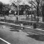
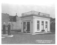
This diminutive Pure Oil gas station was located at the corner of Hudson and Indianola. It had an outdoor lift instead of service bays. The pump globes say Purol and Detonox, indicating the photograph is from the 1920s. Service bays were added to the station later in the decade. Union 76 purchased Pure Oil in 1965, and completely refashioned the station.

Bartlett’s Garage

Friday, September 26th, 2008

Tom Bartlett was a leading Clintonville businessman. His garage at Kelso and High existed for many years. (Photo courtesy of the Clintonville Historical Society)

Playing on the railroad

Friday, September 26th, 2008

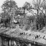
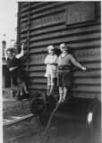
Brevoort brothers Frank Jr., Gordon, and Dale play on a railroad box in or near Worthington, in 1931. (Photo courtesy of Gordon Brevoort)

Standard Oil Station is Outstanding!

Friday, September 26th, 2008

This cute gas station was located at the northern end of the Olentangy Village shopping area in 1939. Today, it is Oldskool restaurant. Is today’s restaurant the same (original) building? I think so. (Photo courtesy of Melissa Goodrich)

Dallas Dupre

Friday, September 26th, 2008

Dallas Dupre, whose son still lives in Greater Columbus, was a landscape architect. He had an office located on the west side of North High Street near Weber Road (3073 North High Street), and is reputed to have been the founder of the early roadside park system throughout the U.S. The Dupre family lived in old Beechwold.

North Broadway bridge

Friday, September 26th, 2008

These photos, from the Franklin County Engineers Office, show the construction of the North Broadway Bridge in 1939. Construction began on March 16, 1939, but was hampered by flood waters on May 23rd. Two shifts of men were used for a period of four of the 8-1/2 months the bridge was under construction, to bring the project to completion on time. The stone facing of the bridge is natural Columbus limestone in various colors.

Note the temporary bridge in the first couple photographs. (Photos courtesy of Franklin County Engineers)

Please note, this post was revised on 2021-10-17 to provide full-size photos when you click through a photo.